SlideShare ist ein Scribd-Unternehmen logo
1 von 9
Making an Orienteering Map in Seven Basic Steps
From Open Street Map to (nearly) Finished Map
1) My Map Project Area in Open Street Map
There is less to start with here than usual. However
the road and river will give a valuable starting
framework. Unseen in the file is important geo-
referencing information that will come in handy with
later information imports.
The area information imported into OCAD 2020 The area information imported
into Open Orienteering Mapper
The OOM preliminary
information converted
to orienteering symbols
I find both mapping programs are very good. Some prefer
OOM because it is free to use. I prefer OCAD because I am
making a lot of maps and it automates some functions that
end up saving me a lot of time.
2a) 2b)Or
Contour Detail Added
In this case the LiDAR contour detail came
from the government of the Province of
Quebec, Canada. (Thanks to Vladimir
Gavrilov of Montreal for his help.) The geo-
referencing of the original map made
positioning of the contour information
automatic and quick.
For similar maps in the United States my go-
to source for LiDAR contour information is a
site called the USGS National Map Viewer.
3)
In many settings valuable and time-saving information can be found from aerial images such as Google Earth.
OCAD 2020 gives the mapper the ability to import the images geo-referenced directly into the maps background.
Otherwise the mapper can manipulate the image into place. Either way it is a great time saver as well as improving
the map product.
A typical aerial image
The image imported into the
map background and detail –
in this case clearings – traced
onto the map
4) Using Satellite / Aerial Images
The geo-reference information in the files of both
the map and aerial image allow my OCAD program
to align the two perfectly with one touch of the
button.
An additional preliminary time saving step is to check an online service such as Strava Heat Map.
The Strava map will show us where hikers, joggers, cyclists, equestrians etc. have gone in the area and recorded their route.
Usually the darker the shown route the more heavily travelled is the path.
5) Strava Global Heat Map
A clip from the Strava Global Heat Map
The Heat Map in our map background
The Strava map will not replace the need to check
those trails for accuracy. However it does show the
field checker where the trails are likely to be.
With information from background
images and Strava this is about as far as
one can get the map.
Next comes checking the area for
additional important details. This is called
field work.
Field Work
To make the map useful for orienteering the mapper
must take the base map out to the area and compare it
to the terrain. Details visible to a person on foot and
important to the orienteer are added/ corrected or
sometimes deleted when they are found to be gone.
Many field workers today take a
mapping tablet with them and do the
field corrections directly onto the
computer.
I’m a bit ‘old-school’. I use a map
board and mylar sheet over the map
with coloured pencils for drawing.
GPS tracks (shown here in purple)
back up my work.
6)
Voila!
A few pleasant days in the forest or park and
the mapper finds the area actually looks like
this. Just add some important ‘layout details’
and a course then the map is ready for
orienteering.
7)

Weitere ähnliche Inhalte

Was ist angesagt?

Change detection techniques
Change detection techniquesChange detection techniques
Change detection techniques
Femi Opaleye
 
Introduction on Photogrammetry.pdf
Introduction on Photogrammetry.pdfIntroduction on Photogrammetry.pdf
Introduction on Photogrammetry.pdf
BSuresh26
 
Manuel utilisateur interface OziExplorer - GPS GLOBE
Manuel utilisateur interface OziExplorer - GPS GLOBEManuel utilisateur interface OziExplorer - GPS GLOBE
Manuel utilisateur interface OziExplorer - GPS GLOBE
GPS Globe 4X4
 
Land navigation part 1
Land navigation part 1Land navigation part 1
Land navigation part 1
Will Rhee
 

Was ist angesagt? (20)

Change detection techniques
Change detection techniquesChange detection techniques
Change detection techniques
 
Fotogrametri dijital sift dan surf
Fotogrametri dijital sift dan surfFotogrametri dijital sift dan surf
Fotogrametri dijital sift dan surf
 
Tutorial agisoft metashape pengolahan data drone - edi supriyanto, st
Tutorial agisoft metashape   pengolahan data drone - edi supriyanto, stTutorial agisoft metashape   pengolahan data drone - edi supriyanto, st
Tutorial agisoft metashape pengolahan data drone - edi supriyanto, st
 
Road construction on mountain
Road construction on mountainRoad construction on mountain
Road construction on mountain
 
Transformasi Koordinat dari DGN 95 ke SRGI 2013
Transformasi Koordinat dari DGN 95 ke SRGI 2013Transformasi Koordinat dari DGN 95 ke SRGI 2013
Transformasi Koordinat dari DGN 95 ke SRGI 2013
 
Etrex basic GPS
Etrex basic GPSEtrex basic GPS
Etrex basic GPS
 
Introduction on Photogrammetry.pdf
Introduction on Photogrammetry.pdfIntroduction on Photogrammetry.pdf
Introduction on Photogrammetry.pdf
 
Manuel utilisateur interface OziExplorer - GPS GLOBE
Manuel utilisateur interface OziExplorer - GPS GLOBEManuel utilisateur interface OziExplorer - GPS GLOBE
Manuel utilisateur interface OziExplorer - GPS GLOBE
 
Exploring Spatial data in GIS Environment
Exploring Spatial data in GIS Environment Exploring Spatial data in GIS Environment
Exploring Spatial data in GIS Environment
 
Mobile mapping system
Mobile mapping systemMobile mapping system
Mobile mapping system
 
GIS for Defence
GIS for DefenceGIS for Defence
GIS for Defence
 
Land navigation part 1
Land navigation part 1Land navigation part 1
Land navigation part 1
 
Pemetaan digital
Pemetaan digital Pemetaan digital
Pemetaan digital
 
Kak tim gps
Kak tim gpsKak tim gps
Kak tim gps
 
Introduction to GIS
Introduction to GISIntroduction to GIS
Introduction to GIS
 
Laporan DGN95 - RSGI
Laporan DGN95 - RSGILaporan DGN95 - RSGI
Laporan DGN95 - RSGI
 
Mengenal Sistem Informasi Geospasial
Mengenal Sistem Informasi GeospasialMengenal Sistem Informasi Geospasial
Mengenal Sistem Informasi Geospasial
 
Contok kerangka acuan kerja
Contok kerangka acuan kerjaContok kerangka acuan kerja
Contok kerangka acuan kerja
 
Map Projections, Datums, GIS and GPS for Everyone
Map Projections, Datums, GIS and GPS for EveryoneMap Projections, Datums, GIS and GPS for Everyone
Map Projections, Datums, GIS and GPS for Everyone
 
Transformasi Datum
Transformasi DatumTransformasi Datum
Transformasi Datum
 

Ähnlich wie Making an Orienteering Map in Seven Basic Steps

Producing Geographic Data with LIDAR
Producing Geographic Data with LIDARProducing Geographic Data with LIDAR
Producing Geographic Data with LIDAR
Kodi Volkmann
 
碩一工研院研究成果
碩一工研院研究成果碩一工研院研究成果
碩一工研院研究成果
Shaun Lin
 
PREPARATION OF ROAD NETWORK FROM SATELLITE IMAGERY
PREPARATION OF ROAD NETWORK FROM SATELLITE IMAGERYPREPARATION OF ROAD NETWORK FROM SATELLITE IMAGERY
PREPARATION OF ROAD NETWORK FROM SATELLITE IMAGERY
Philson Philipose
 
Total station and its application to civil engineering
Total station and its application to civil engineeringTotal station and its application to civil engineering
Total station and its application to civil engineering
Tushar Dholakia
 

Ähnlich wie Making an Orienteering Map in Seven Basic Steps (20)

Producing Geographic Data with LIDAR
Producing Geographic Data with LIDARProducing Geographic Data with LIDAR
Producing Geographic Data with LIDAR
 
Application of Vision based Techniques for Position Estimation
Application of Vision based Techniques for Position EstimationApplication of Vision based Techniques for Position Estimation
Application of Vision based Techniques for Position Estimation
 
碩一工研院研究成果
碩一工研院研究成果碩一工研院研究成果
碩一工研院研究成果
 
APPLICATION OF GPS IN ORIENTEERING COMPETITIONS
APPLICATION OF GPS IN ORIENTEERING COMPETITIONSAPPLICATION OF GPS IN ORIENTEERING COMPETITIONS
APPLICATION OF GPS IN ORIENTEERING COMPETITIONS
 
Data sources and input in GIS
Data  sources and input in GISData  sources and input in GIS
Data sources and input in GIS
 
Online Mapping
Online MappingOnline Mapping
Online Mapping
 
PREPARATION OF ROAD NETWORK FROM SATELLITE IMAGERY
PREPARATION OF ROAD NETWORK FROM SATELLITE IMAGERYPREPARATION OF ROAD NETWORK FROM SATELLITE IMAGERY
PREPARATION OF ROAD NETWORK FROM SATELLITE IMAGERY
 
IRJET- Simultaneous Localization and Mapping for Automatic Chair Re-Arran...
IRJET-  	  Simultaneous Localization and Mapping for Automatic Chair Re-Arran...IRJET-  	  Simultaneous Localization and Mapping for Automatic Chair Re-Arran...
IRJET- Simultaneous Localization and Mapping for Automatic Chair Re-Arran...
 
9-IJTPE-Issue53-Vol14-No4-Dec2022-pp75-79.pdf
9-IJTPE-Issue53-Vol14-No4-Dec2022-pp75-79.pdf9-IJTPE-Issue53-Vol14-No4-Dec2022-pp75-79.pdf
9-IJTPE-Issue53-Vol14-No4-Dec2022-pp75-79.pdf
 
9-IJTPE-Issue53-Vol14-No4-Dec2022-pp75-79.pdf
9-IJTPE-Issue53-Vol14-No4-Dec2022-pp75-79.pdf9-IJTPE-Issue53-Vol14-No4-Dec2022-pp75-79.pdf
9-IJTPE-Issue53-Vol14-No4-Dec2022-pp75-79.pdf
 
CycleStreets: Our Story - presentation to Net2Camb event
CycleStreets: Our Story - presentation to Net2Camb eventCycleStreets: Our Story - presentation to Net2Camb event
CycleStreets: Our Story - presentation to Net2Camb event
 
Accuracy checks in the production of orthophotos
Accuracy checks in the production of orthophotosAccuracy checks in the production of orthophotos
Accuracy checks in the production of orthophotos
 
Total station and its application to civil engineering
Total station and its application to civil engineeringTotal station and its application to civil engineering
Total station and its application to civil engineering
 
LocalizationandMappingforAutonomousNavigationin OutdoorTerrains: A StereoVisi...
LocalizationandMappingforAutonomousNavigationin OutdoorTerrains: A StereoVisi...LocalizationandMappingforAutonomousNavigationin OutdoorTerrains: A StereoVisi...
LocalizationandMappingforAutonomousNavigationin OutdoorTerrains: A StereoVisi...
 
OpenStreetMap - The Quality Issue
OpenStreetMap - The Quality IssueOpenStreetMap - The Quality Issue
OpenStreetMap - The Quality Issue
 
Presentation on progress report of final year project(gps
Presentation on progress report of final year project(gpsPresentation on progress report of final year project(gps
Presentation on progress report of final year project(gps
 
Heads up digitization- ON THE FLY- GIS
Heads up digitization- ON THE FLY- GISHeads up digitization- ON THE FLY- GIS
Heads up digitization- ON THE FLY- GIS
 
digitalcartography in gis-200627114438 (1).pdf
digitalcartography in gis-200627114438 (1).pdfdigitalcartography in gis-200627114438 (1).pdf
digitalcartography in gis-200627114438 (1).pdf
 
Digitalcartography
DigitalcartographyDigitalcartography
Digitalcartography
 
GeOng presentation about OpenStreetMap
GeOng presentation about OpenStreetMapGeOng presentation about OpenStreetMap
GeOng presentation about OpenStreetMap
 

Mehr von Gord Hunter

Mehr von Gord Hunter (17)

2012 Mad Trapper Rogaine promo.pptx
2012 Mad Trapper Rogaine promo.pptx2012 Mad Trapper Rogaine promo.pptx
2012 Mad Trapper Rogaine promo.pptx
 
Advice for Orienteering Coaches
Advice for Orienteering CoachesAdvice for Orienteering Coaches
Advice for Orienteering Coaches
 
Instructions for north florida jrotc orienteering championships
Instructions  for  north florida  jrotc orienteering championshipsInstructions  for  north florida  jrotc orienteering championships
Instructions for north florida jrotc orienteering championships
 
Safety brief and notes for 2021 Florida JROTC Orienteering Championships
Safety brief and notes for 2021 Florida JROTC Orienteering ChampionshipsSafety brief and notes for 2021 Florida JROTC Orienteering Championships
Safety brief and notes for 2021 Florida JROTC Orienteering Championships
 
Life and times of jim hunter
Life and times of jim hunterLife and times of jim hunter
Life and times of jim hunter
 
Livelox as a Training Aid
Livelox as a Training AidLivelox as a Training Aid
Livelox as a Training Aid
 
Norval green demo
Norval green demoNorval green demo
Norval green demo
 
The anatomy of an orienteering course
The anatomy of an orienteering courseThe anatomy of an orienteering course
The anatomy of an orienteering course
 
Orienteering: What's It All About?
Orienteering: What's It All About?Orienteering: What's It All About?
Orienteering: What's It All About?
 
Orienteering: That sounds like fun
Orienteering: That sounds like funOrienteering: That sounds like fun
Orienteering: That sounds like fun
 
2014 Suncoast Orienteering Championships instructions
2014 Suncoast Orienteering Championships   instructions2014 Suncoast Orienteering Championships   instructions
2014 Suncoast Orienteering Championships instructions
 
Orienteering comes to Dade Park
Orienteering comes to Dade ParkOrienteering comes to Dade Park
Orienteering comes to Dade Park
 
2013 Suncoast JROTC Team Orienteering Championships
2013 Suncoast JROTC Team Orienteering Championships2013 Suncoast JROTC Team Orienteering Championships
2013 Suncoast JROTC Team Orienteering Championships
 
2012 Florida Orienteering Championships
2012 Florida Orienteering Championships2012 Florida Orienteering Championships
2012 Florida Orienteering Championships
 
2012 12 08 Florida Orienteering Championships
2012 12 08 Florida Orienteering Championships2012 12 08 Florida Orienteering Championships
2012 12 08 Florida Orienteering Championships
 
Orienteering: What's That? - A Look Back
Orienteering: What's That? - A Look BackOrienteering: What's That? - A Look Back
Orienteering: What's That? - A Look Back
 
A Look Back at My Sisters' Early Years
A Look Back at My Sisters' Early YearsA Look Back at My Sisters' Early Years
A Look Back at My Sisters' Early Years
 

Kürzlich hochgeladen

+971565801893>>SAFE AND ORIGINAL ABORTION PILLS FOR SALE IN DUBAI AND ABUDHAB...
+971565801893>>SAFE AND ORIGINAL ABORTION PILLS FOR SALE IN DUBAI AND ABUDHAB...+971565801893>>SAFE AND ORIGINAL ABORTION PILLS FOR SALE IN DUBAI AND ABUDHAB...
+971565801893>>SAFE AND ORIGINAL ABORTION PILLS FOR SALE IN DUBAI AND ABUDHAB...
Health
 
Asli Kala jadu, Black magic specialist in Pakistan Or Kala jadu expert in Egy...
Asli Kala jadu, Black magic specialist in Pakistan Or Kala jadu expert in Egy...Asli Kala jadu, Black magic specialist in Pakistan Or Kala jadu expert in Egy...
Asli Kala jadu, Black magic specialist in Pakistan Or Kala jadu expert in Egy...
baharayali
 

Kürzlich hochgeladen (20)

Spain Vs Albania- Spain at risk of being thrown out of Euro 2024 with Tournam...
Spain Vs Albania- Spain at risk of being thrown out of Euro 2024 with Tournam...Spain Vs Albania- Spain at risk of being thrown out of Euro 2024 with Tournam...
Spain Vs Albania- Spain at risk of being thrown out of Euro 2024 with Tournam...
 
Technical Data | Sig Sauer Easy6 BDX 1-6x24 | Optics Trade
Technical Data | Sig Sauer Easy6 BDX 1-6x24 | Optics TradeTechnical Data | Sig Sauer Easy6 BDX 1-6x24 | Optics Trade
Technical Data | Sig Sauer Easy6 BDX 1-6x24 | Optics Trade
 
UEFA Euro 2024 Squad Check-in Who is Most Favorite.docx
UEFA Euro 2024 Squad Check-in Who is Most Favorite.docxUEFA Euro 2024 Squad Check-in Who is Most Favorite.docx
UEFA Euro 2024 Squad Check-in Who is Most Favorite.docx
 
Unveiling the Mystery of Main Bazar Chart
Unveiling the Mystery of Main Bazar ChartUnveiling the Mystery of Main Bazar Chart
Unveiling the Mystery of Main Bazar Chart
 
European Football Icons that Missed Opportunities at UEFA Euro 2024.docx
European Football Icons that Missed Opportunities at UEFA Euro 2024.docxEuropean Football Icons that Missed Opportunities at UEFA Euro 2024.docx
European Football Icons that Missed Opportunities at UEFA Euro 2024.docx
 
+971565801893>>SAFE AND ORIGINAL ABORTION PILLS FOR SALE IN DUBAI AND ABUDHAB...
+971565801893>>SAFE AND ORIGINAL ABORTION PILLS FOR SALE IN DUBAI AND ABUDHAB...+971565801893>>SAFE AND ORIGINAL ABORTION PILLS FOR SALE IN DUBAI AND ABUDHAB...
+971565801893>>SAFE AND ORIGINAL ABORTION PILLS FOR SALE IN DUBAI AND ABUDHAB...
 
Spain Vs Italy Spain to be banned from participating in Euro 2024.docx
Spain Vs Italy Spain to be banned from participating in Euro 2024.docxSpain Vs Italy Spain to be banned from participating in Euro 2024.docx
Spain Vs Italy Spain to be banned from participating in Euro 2024.docx
 
Croatia vs Italy Euro Cup 2024 Three pitfalls for Spalletti’s Italy in Group ...
Croatia vs Italy Euro Cup 2024 Three pitfalls for Spalletti’s Italy in Group ...Croatia vs Italy Euro Cup 2024 Three pitfalls for Spalletti’s Italy in Group ...
Croatia vs Italy Euro Cup 2024 Three pitfalls for Spalletti’s Italy in Group ...
 
JORNADA 6 LIGA MURO 2024TUXTEPECOAXACA.pdf
JORNADA 6 LIGA MURO 2024TUXTEPECOAXACA.pdfJORNADA 6 LIGA MURO 2024TUXTEPECOAXACA.pdf
JORNADA 6 LIGA MURO 2024TUXTEPECOAXACA.pdf
 
Slovenia Vs Serbia UEFA Euro 2024 Fixture Guide Every Fixture Detailed.docx
Slovenia Vs Serbia UEFA Euro 2024 Fixture Guide Every Fixture Detailed.docxSlovenia Vs Serbia UEFA Euro 2024 Fixture Guide Every Fixture Detailed.docx
Slovenia Vs Serbia UEFA Euro 2024 Fixture Guide Every Fixture Detailed.docx
 
Who Is Emmanuel Katto Uganda? His Career, personal life etc.
Who Is Emmanuel Katto Uganda? His Career, personal life etc.Who Is Emmanuel Katto Uganda? His Career, personal life etc.
Who Is Emmanuel Katto Uganda? His Career, personal life etc.
 
Italy vs Albania Italy Euro 2024 squad Luciano Spalletti's full team ahead of...
Italy vs Albania Italy Euro 2024 squad Luciano Spalletti's full team ahead of...Italy vs Albania Italy Euro 2024 squad Luciano Spalletti's full team ahead of...
Italy vs Albania Italy Euro 2024 squad Luciano Spalletti's full team ahead of...
 
JORNADA 5 LIGA MURO 2024INSUGURACION.pdf
JORNADA 5 LIGA MURO 2024INSUGURACION.pdfJORNADA 5 LIGA MURO 2024INSUGURACION.pdf
JORNADA 5 LIGA MURO 2024INSUGURACION.pdf
 
Netherlands Players expected to miss UEFA Euro 2024 due to injury.docx
Netherlands Players expected to miss UEFA Euro 2024 due to injury.docxNetherlands Players expected to miss UEFA Euro 2024 due to injury.docx
Netherlands Players expected to miss UEFA Euro 2024 due to injury.docx
 
Sports Writing (Rules,Tips, Examples, etc)
Sports Writing (Rules,Tips, Examples, etc)Sports Writing (Rules,Tips, Examples, etc)
Sports Writing (Rules,Tips, Examples, etc)
 
Cricket Api Solution.pdfCricket Api Solution.pdf
Cricket Api Solution.pdfCricket Api Solution.pdfCricket Api Solution.pdfCricket Api Solution.pdf
Cricket Api Solution.pdfCricket Api Solution.pdf
 
Hire 💕 8617697112 Kasauli Call Girls Service Call Girls Agency
Hire 💕 8617697112 Kasauli Call Girls Service Call Girls AgencyHire 💕 8617697112 Kasauli Call Girls Service Call Girls Agency
Hire 💕 8617697112 Kasauli Call Girls Service Call Girls Agency
 
Asli Kala jadu, Black magic specialist in Pakistan Or Kala jadu expert in Egy...
Asli Kala jadu, Black magic specialist in Pakistan Or Kala jadu expert in Egy...Asli Kala jadu, Black magic specialist in Pakistan Or Kala jadu expert in Egy...
Asli Kala jadu, Black magic specialist in Pakistan Or Kala jadu expert in Egy...
 
WhatsApp Chat: 📞 8617697112 Birbhum Call Girl available for hotel room package
WhatsApp Chat: 📞 8617697112 Birbhum  Call Girl available for hotel room packageWhatsApp Chat: 📞 8617697112 Birbhum  Call Girl available for hotel room package
WhatsApp Chat: 📞 8617697112 Birbhum Call Girl available for hotel room package
 
Albania Vs Spain South American coaches lead Albania to Euro 2024 spot.docx
Albania Vs Spain South American coaches lead Albania to Euro 2024 spot.docxAlbania Vs Spain South American coaches lead Albania to Euro 2024 spot.docx
Albania Vs Spain South American coaches lead Albania to Euro 2024 spot.docx
 

Making an Orienteering Map in Seven Basic Steps

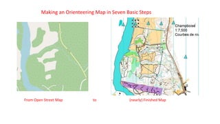
  • 1. Making an Orienteering Map in Seven Basic Steps From Open Street Map to (nearly) Finished Map
  • 2. 1) My Map Project Area in Open Street Map There is less to start with here than usual. However the road and river will give a valuable starting framework. Unseen in the file is important geo- referencing information that will come in handy with later information imports.
  • 3. The area information imported into OCAD 2020 The area information imported into Open Orienteering Mapper The OOM preliminary information converted to orienteering symbols I find both mapping programs are very good. Some prefer OOM because it is free to use. I prefer OCAD because I am making a lot of maps and it automates some functions that end up saving me a lot of time. 2a) 2b)Or
  • 4. Contour Detail Added In this case the LiDAR contour detail came from the government of the Province of Quebec, Canada. (Thanks to Vladimir Gavrilov of Montreal for his help.) The geo- referencing of the original map made positioning of the contour information automatic and quick. For similar maps in the United States my go- to source for LiDAR contour information is a site called the USGS National Map Viewer. 3)
  • 5. In many settings valuable and time-saving information can be found from aerial images such as Google Earth. OCAD 2020 gives the mapper the ability to import the images geo-referenced directly into the maps background. Otherwise the mapper can manipulate the image into place. Either way it is a great time saver as well as improving the map product. A typical aerial image The image imported into the map background and detail – in this case clearings – traced onto the map 4) Using Satellite / Aerial Images The geo-reference information in the files of both the map and aerial image allow my OCAD program to align the two perfectly with one touch of the button.
  • 6. An additional preliminary time saving step is to check an online service such as Strava Heat Map. The Strava map will show us where hikers, joggers, cyclists, equestrians etc. have gone in the area and recorded their route. Usually the darker the shown route the more heavily travelled is the path. 5) Strava Global Heat Map A clip from the Strava Global Heat Map The Heat Map in our map background The Strava map will not replace the need to check those trails for accuracy. However it does show the field checker where the trails are likely to be.
  • 7. With information from background images and Strava this is about as far as one can get the map. Next comes checking the area for additional important details. This is called field work.
  • 8. Field Work To make the map useful for orienteering the mapper must take the base map out to the area and compare it to the terrain. Details visible to a person on foot and important to the orienteer are added/ corrected or sometimes deleted when they are found to be gone. Many field workers today take a mapping tablet with them and do the field corrections directly onto the computer. I’m a bit ‘old-school’. I use a map board and mylar sheet over the map with coloured pencils for drawing. GPS tracks (shown here in purple) back up my work. 6)
  • 9. Voila! A few pleasant days in the forest or park and the mapper finds the area actually looks like this. Just add some important ‘layout details’ and a course then the map is ready for orienteering. 7)