Geoscience satellite image processing
•
16 gefällt mir•8,521 views

Satellite image processing involves correcting satellite images for defects, overlaying the 2D images onto a 3D model of Earth, and applying the images for scientific and practical uses. Early satellite photographs from the 1940s and 1950s provided initial images of Earth and the Moon. Modern satellite image processing utilizes large amounts of data from numerous sensors and satellites to monitor the planet. Cloud computing provides advanced infrastructure for processing large satellite images, performing corrections, and generating meaningful results through on-demand public and private cloud resources.

Empfohlen
Empfohlen
Weitere ähnliche Inhalte
Was ist angesagt?
Was ist angesagt? (20)
Andere mochten auch
Ähnlich wie Geoscience satellite image processing
Ähnlich wie Geoscience satellite image processing (20)
Mehr von gaurav jain
Mehr von gaurav jain (20)
Kürzlich hochgeladen
Kürzlich hochgeladen (20)
Geoscience satellite image processing
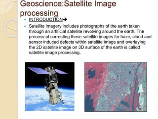
- 1. Geoscience:Satellite Image processing INTRODUCTION Satellite imagery includes photographs of the earth taken through an artificial satellite revolving around the earth. The process of correcting these satellite images for haze, cloud and sensor induced defects within satellite image and overlaying the 2D satellite image on 3D surface of the earth is called satellite image processing.
- 2. Geoscience:Satellite Image processing Processed satellite images have different scientific and need based applications in the field of agriculture, geology, forestry, biodiversity conservation, regional planning, education, intelligence and warfare. HISTORYThe first images from space were taken on sub-orbital flights. The U.S-launched V- 2 flight on October 24, 1946 took one image every 1.5 seconds. The first satellite (orbital) photographs of Earth were made on August 14, 1959 by the U.S. Explorer 6. The first satellite photographs of the Moon might have been made on October 6, 1959 by the Soviet satellite Luna 3, on a mission
- 3. Geoscience:Satellite Image processing These type of applications collects, Produce and analyze a huge amount of data. By Deploying the sensor and satellites for monitoring the technology our planet will become more instrumented. Due to the development of geological information system is a major implementation in the field of geological science. The GIS applications can process all types of geographically referenced data. This information is useful for for civil security purpose
- 4. Geoscience:Satellite Image processing Cloud computing is an advancement for these kind of application for generating meaningful result. The satellite image sensing generates a lot of raw images that needs to be processed further. This requires the high computation in both Input and Output manner. The large size images can be transferred from the local ground station to cloud computing facilities for further solution and corrections. The cloud computing will provide an accurate infrastructure for these kind of services.
- 5. Geoscience:Satellite Image processing A cloud based advancement has been developed by The department of space and research(Govt of India) . Saas portal Local storage Archiving Private cloud Public cloud
- 6. Geoscience:Satellite Image processing The following fig states that different types of technologies are integrated in entire computing environment. The SAAS service consists the collection of services for geo code generation and data visualization. Aneka controls the Sending and receiving of data in the infrastructure. And the processing of these image processing tasks produced the desired outcome from the raw satellite images. The public and private cloud will provide the resources on-demand.