Mark scheme for the geographical enquiry
•Als DOC, PDF herunterladen•
0 gefällt mir•585 views

WJEC B Geography

Empfohlen
Weitere ähnliche Inhalte
Was ist angesagt?
Was ist angesagt? (18)
Andere mochten auch
Andere mochten auch (20)
Ähnlich wie Mark scheme for the geographical enquiry
Ähnlich wie Mark scheme for the geographical enquiry (20)
Mehr von David Rogers
Mehr von David Rogers (20)
Kürzlich hochgeladen
Kürzlich hochgeladen (20)
Mark scheme for the geographical enquiry
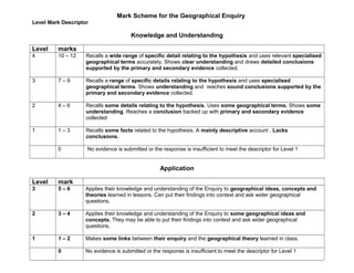
- 1. Mark Scheme for the Geographical Enquiry Level Mark Descriptor Knowledge and Understanding Level marks 4 10 – 12 Recalls a wide range of specific detail relating to the hypothesis and uses relevant specialised geographical terms accurately. Shows clear understanding and draws detailed conclusions supported by the primary and secondary evidence collected. 3 7 – 9 Recalls a range of specific details relating to the hypothesis and uses specialised geographical terms. Shows understanding and reaches sound conclusions supported by the primary and secondary evidence collected. 2 4 – 6 Recalls some details relating to the hypothesis. Uses some geographical terms. Shows some understanding. Reaches a conclusion backed up with primary and secondary evidence collected 1 1 – 3 Recalls some facts related to the hypothesis. A mainly descriptive account . Lacks conclusions. 0 No evidence is submitted or the response is insufficient to meet the descriptor for Level 1 Application Level mark 3 5 – 6 Applies their knowledge and understanding of the Enquiry to geographical ideas, concepts and theories learned in lessons. Can put their findings into context and ask wider geographical questions. 2 3 – 4 Applies their knowledge and understanding of the Enquiry to some geographical ideas and concepts. They may be able to put their findings into context and ask wider geographical questions. 1 1 – 2 Makes some links between their enquiry and the geographical theory learned in class. 0 No evidence is submitted or the response is insufficient to meet the descriptor for Level 1
- 2. Skills Level mark 4 10 – 12 Throughout, uses a wide range of entirely appropriate techniques to collect, record, select, process, refine and present primary and secondary data. The work shows a logical sequence. Excellent linkage of graphs to text. Excellent evaluation of methods of primary and secondary data collection. Comments on the reliability and limitations of the data collected. Presentation and analysis of the evidence is of a high level. Excellent communication skills including spelling, punctuation and grammar. 3 7 – 9 Throughout, uses a wide range of techniques to collect, record, select, process, refine and present primary and secondary data. The work has a logical sequence and the there is good linkage of graphs to text. Good evaluation of the collection of primary data, and comments on the reliability of the conclusions. Good communication skills. Spelling, punctuation and grammar is mostly accurate. 2 4 – 6 Uses a range of techniques to present their work. Some primary and secondary data is used. The work has a logical sequence. Has tried to link graphs to text. Has tried to evaluate the collection of primary data. Writing is easy to understand and spelling, punctuation and grammar are quite good. . 1 1 – 3 Uses a range of techniques to present their work. The written work lacks structure or a logical sequence. Only a small amount of primary or secondary data is used. Does not refer to their graphs in their writing. Spelling, punctuation and grammar are weak. 0 No evidence is submitted or the response is insufficient to meet the descriptor for Level 1
- 3. Notes: 2. Do you need to write a methodology for their Enquiry? No. The new mark scheme for the current Enquiry does not give any marks for describing the method, so my advice is to leave it out. Readers of the finished task will be able to recognise the methods used in collecting, collating, processing and refining the data. It is in the evaluation you can reflect on your methodology. Discuss the strengths of a wide evidence base, discuss the value of sharing the outcomes of questionnaires and bi-polar surveys to increase statistical rigour and encourage more confident analysis. Offer a critique of your data collection, perhaps on the numbers used in surveys, the time when the survey was undertaken etc. There are marks for candidates who can relate their Enquiry to their wider geographical studies (see paragraph 1.3 below). Therefore, it would be sensible to use a structure along these lines: • Where is my study located? • What concepts / issues / theories am I investigating? • What does my data tell me? • How do my findings compare to what I expected? • What was my overall conclusion about the hypothesis? • How could my project be improved? Notes from the examiner….. 1.3 How can students access the marks for AO2 in the Enquiry? It should be relatively easy for students to access marks for AO1 by doing things like: • Describing the location and scale of the specific area of study • Describing and explaining facts about the specific place they have studied • Reaching conclusions about the specific place they have studied based on the data they have processed. However, to gain marks for AO2, candidates need to apply what they have seen at the specific study site to their wider geographical knowledge and understanding. This means that students need to be aware of the concepts / processes / issues / ideas or theories that underpin their investigation. They are unlikely to write about this unless they realise that it’s needed – so please share the mark scheme with your students and give them strategies to help them incorporate their wider geographical understanding. There are various ways of doing this. One simple way is to ask them to write a paragraph describing the underlying concepts. (However, this can be presented as a ‘bolt- on’ section that does not properly relate to the student’s own observations at the site of the fieldwork, in which case the student will find it difficult to get beyond level 2) Another simple way to get around the problem is to show the students a video on the topic that is under investigation as part of their teaching and learning prior to the fieldtrip. Students can then comment on the differences and similarities between the impacts they observed at their own site, compared to the general problems that were described in the video. Any cross referencing to case study material is helpful in gaining AO2 marks. Moreover, more able students will be able to comment on how far their field study site is typical or atypical of other places.
- 4. 3. Examiners’ Report 2011 GEOGRAPHY – SPECIFICATION B General Certificate of Secondary Education Summer 2011 Principal Moderator: Andy Leeder Principal Moderator's Report (Unit 3) General comments: Action points regarding the Enquiry: • Centres should devise strategies to ensure that candidates understand how to access the assessment criteria for AO2 – Application (this action point to be developed at CPD events*). • To ensure that the volume of secondary data made available through supporting resource documents and / or acquired through individual research, is manageable, given the time constraints of controlled assessment. This is particularly applicable to statistical data (e.g. Census data in the Quality of Life tasks and physical process data, acquired, for example, through beach profiling in Coastal Management tasks). • To ensure that candidates understand the need to acknowledge the source of secondary material included in their completed task. • Where secondary material, often sourced from the internet, is included within the body of a candidate's work, candidates need to understand how to maximise skills marks from the inclusion of such material. Too often, candidates resort to cut and paste without developing the resource or maximising its usefulness (this action point will also be developed at the 2011 CPD events*). • To ensure that the hypothesis (or hypotheses) developed from the generic titles available on page 32 of the Specification, provide sufficient challenge to aid differentiation. 27