5. Deepwater Horizon mobile offshore drilling unit drilling an exploratory well at a
water depth of approximately 1,500 m about 66 km off the Louisiana coast.
6. Deepwater Horizon mobile offshore drilling unit drilling an exploratory well at a
water depth of approximately 1,500 m about 66 km off the Louisiana coast.
Methane gas from the well, under high pressure, shot all the way up and out
of the drill column, ignited and exploded.
7. Deepwater Horizon mobile offshore drilling unit drilling an exploratory well at a
water depth of approximately 1,500 m about 66 km off the Louisiana coast.
Methane gas from the well, under high pressure, shot all the way up and out
of the drill column, ignited and exploded.
Eleven workers were never found despite a three-day Coast Guard search
operation Efforts by multiple ships to douse the flames were unsuccessful.
8.
9. After burning for approximately 36 hours, the Deepwater Horizon sank.
10.
11. Coast Guard Rear Admiral Mary Landry announced that a damaged wellhead
was leaking.
12. Coast Guard Rear Admiral Mary Landry announced that a damaged wellhead
was leaking.
She stated that "the leak was a new discovery but could have begun when
the offshore platform sank ... two days after the initial explosion."
13.
14. The oil spill covered 1,500 square km and was only 50 km from the
ecologically sensitive Chandeleur Islands.
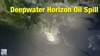
15. The oil spill covered 1,500 square km and was only 50 km from the
ecologically sensitive Chandeleur Islands.
The oil's spread was initially increased by strong southerly winds caused by
an impending cold front.
16.
17. The National Oceanic and Atmospheric Administration estimated that the leak
was likely 5,000 barrels a day, five times larger than initially estimated by BP.
18.
19. The National Oceanic and Atmospheric Administration and other scientists
monitoring the spill stated that oil had reached the Loop Current, which flows
clockwise around the Gulf of Mexico towards Florida and then joins the Gulf
Stream along the U.S. east coast.
20. The National Oceanic and Atmospheric Administration and other scientists
monitoring the spill stated that oil had reached the Loop Current, which flows
clockwise around the Gulf of Mexico towards Florida and then joins the Gulf
Stream along the U.S. east coast.
Oil washes ashore on mainland Louisiana.
21.
22. Flow Rate Technical Group says the leak could be 20,000 to 40,000 barrels of
oil a day.
23.
24. The wellhead was capped on July 15 and by July 30 the oil appeared to have
dissipated more rapidly than expected.