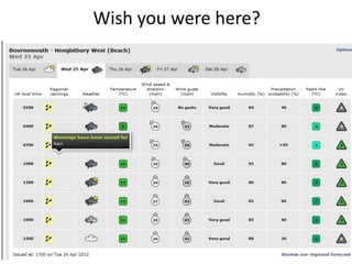
3. Annotated image
• What image could you use?
• Annotate to show land use / describe the area
/ link to your key question / link to theory
4.
5.
6.
7.
8. Background research & planning
• Use the iPads to do your background research
• Find secondary sources to inform your project
• Why not investigate the nature reserve / SSSI?
Why is H.H. protected? What sea defences are
there? How much is spent? Beach hut values?
How many tourists? Etc.
• Remember to record information in your critical
bibliography
9. Webpage Title / Author Point of view / Evaluation (is it
information reliable, biased?
given )
12. The data you will collect includes:
• Beach profiling
• Groyne measurements
1. Try to link each
• Pebble analysis technique to a key
question
• Photos 2. Suggest how you will
present the data
• Field sketches (type of graph / map /
diagram / etc)
• Land use map
• Questionaire
13. What does it show?
e.g. Beach Which Key question?
profiles - Shows the cross-
section of the beach
- Demonstrates beach
shape / depth / width
- Could show effects of
LSD
• Beach profiling
• Groyne
measurements
• Pebble analysis How would you
• Photos present the data?
• Field sketches - Cross section graph
• Land use map - Profile line graph
• Questionaire