AirSense - Neogeography
•
2 gefällt mir•626 views

Using mini UAV for high res. aerial photo.

Empfohlen
Weitere ähnliche Inhalte
Andere mochten auch
Andere mochten auch (16)
Ähnlich wie AirSense - Neogeography
Ähnlich wie AirSense - Neogeography (20)
Mehr von Ismail Ibrahim
Kürzlich hochgeladen
Kürzlich hochgeladen (20)
AirSense - Neogeography
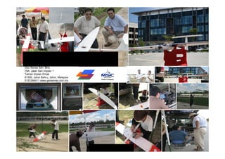
- 1. Unmanned Aerial Remote Sensing Services (UAV) Geo Sense Sdn. Bhd. 79A, Jalan Seri Impian 1 Taman Impian Emas 81300, Johor Bahru, Johor, Malaysia 0197266411 www.geosense.com.my www.geosense.info
- 2. Agenda • Background of project ideas – Neogeography, Google experience • Traditional mapping & direction • Traditional GIS vs Neogeography, – needs for simplicity, visualization and collaboration medium • Visualization requirement – Aerial imagery source & limitation • Civilian UAV applications • Geo Sense Experience, local civilian UAV operators – Potential Applications • Sharing Aerial Images / Results
- 4. Keyholes, Launch 2005 earth visualization, mapping & Geo Info System
- 5. and the first thing most people did was look for their house, awesome experience, geo peeping, location awareness
- 6. 2005 - Mid 2006 with only satellite imagery available, identifying problem, take time to navigate, limited tagging
- 7. Mid 2006 onward integration with street maps, fast recognition, fast search (browse), more public participation
- 8. Democratization of Geo Data, thousands of public tagging data, sharing, indexing world data geographically
- 9. Google Map, API extends Geo Services to thousands of developers, Google Map Mania, etc
- 12. Where 2.0, Neogeography, GIS meets Web
- 13. Web 2.0 Where 2.0 Geo - Web
- 14. What next, Mobile navigation, LBS, augmented reality
- 15. What about traditional mapping
- 21. Open street map, world movement on free map, collective contribution, collaboration
- 29. Map layers in visualization system / GIS
- 30. GIS is highly technical system (structure, standard) of hosting, and relating layers of maps (geo info) in one platform
- 31. More Than 70% of Gov Data is Geographically Based Subject – Name / Account / Customers / Assets. etc Location – Address / Territory / Building / Zoning etc Description / Status etc. GIS manages relationship, and present various layers of geo location data Visualization enable faster decision making
- 32. Underutilization of GIS Capability GIS IT / WWW
- 33. Need To Simplify Complex System Typical GIS Interface (College training) Google Map (30 min training) Platform visual web-based yang ringkas dengan data asas yang dapat dikongsi oleh pelbagai jabatan (visual platform – semua lapisan penguna dapat memahami dengan pantas)
- 34. GIS on Demand Community Holistic Application (GODCHA) Open Source / WGIS / PPGIS
- 35. GODCHA, web GIS, API, data integration, collaboration presentation
- 36. Local Gov uses Mapping platform for Community collaboration / local information / Info gathering, Open data movement http://www.vic.gov.au/visualplace/map.html
- 37. The important of visualization Using Aerial photo for effective visualization & Planning
- 38. Finding.. Decision maker are mostly non technical Google Awareness Needs more integration maps & satellite image Visualization powers to layman Neogeography User centric than map centric Nusajaya
- 39. The needs for high resolution & up to date visualization contents An alternative to satellite image
- 40. Sources of Aerial Imaging Perolehan imej satellite adalah terhad, walaupun ada di Google, tetapi imej-imej tersebut adalah ber-resolusi Pesawat Ringan rendah serta tidak terkini. Untuk mendapatkan imej ber- Imaging ketinggian 10k – 30k kaki resolusi tinggi, pesawat ringan dan helikopter Satellite digunakan, namum kos agak tinggi dan kurang ekonomik untuk liputan yang kecil, 500-800 km Cost Pesawat ringan & Pesawat RC / UAV helikopter Ketinggian 500 – 5000 kaki juga tidak • Aerial Camera System sesuai • Radiometric resolution untuk kerja- • 3 in – 60 in resolution kerja (avg 30 in resolution) pengintipan Cloud Issues • Aerial mapping survey , kerana • IPSAR (SAR) / LIDAR saiz serta • Natural color (RGB) deruan • 7 - 15 cm resolution engin yang • Surveillance / Monitoring kuat 200 meter 90 km 3 km 300 meter 30 km 3 km
- 41. Limitation of Satellite Images Tangkak Muar Kota Tinggi Batu Pahat Resolusi Imej yang rendah dan tidak kemas kini
- 42. Limitation of Satellite Images / Google free Images – Cloud cover Limited resolution (60 – 200 cm) Out dated (Gooogle average 3 years / Aerial photo - 1 – 4 mth) Danga Bay Geo Sense Sdn. Bhd.
- 43. References to Google Earth -Tidak kemas-kini - Had resolusi (> 1 meter) - Kebergantungan teknologi luar - Persoalan Keselamatan Data
- 44. Part of Study Areas (Future Development & Monitoring) Imej lama 2 tahun atau lebih Kejelasan melebihi 2 meter resolusi per pixel Liputan awan 60%
- 45. Light Aircraft with sosphicated aerial camera system taking aerial images for remote sensing and mapping Contoh Imej Pesawat Ringan - Terbang lebih tinggi – kawasan liputan lebih meluas - Tambah Nilai – Muatan - Multi spectrum camera, LIDAR, 3D Camera etc - Tertakluk kebenaran penerbangan (DCA) - Kepakaran yang kurang - kos perolehan dan pengendalian yang tinggi. Geo Sense Sdn. Bhd.
- 46. Hobbyists, RC, aerial photography, limited angles & non precision
- 47. Civilian UAV movement & promise meeting MLB at Where 2.0 2006, GPS guided more precise / precision
- 48. Civilian UAV Project Study Dr Stephan J Morris David Riallant Chris Anderson Li Jing, Prof. MLB UAV Pict’ Earth Chief Editor Wired Magazine Beijing University President & Founder Image Processing Specialist Founder DIY Drone Author The Long Tail
- 49. Canadian Micropilot, autopilot makers, Cropcam, mini glider based UAV for remote sensing
- 50. From War to Peace Civilian UAV Development
- 52. ORBITAL low earth orbit (Mach 25+) HALE (high altitude, long endurance) over 30,000 ft and indefinite range Type of UAV MALE (medium altitude, long endurance) up to 30,000 ft (9,000 m) and range over 200 km NATO type 10,000 ft (3,000 m) altitude, up to 50 km range Tactical 18,000 ft (5,500 m) altitude, about 160 km range HYPERSONIC high-speed, supersonic (Mach 1-5) or hypersonic (Mach 5+) 50,000 ft (15,200 m) or suborbital altitude, range over 200km Handheld 2,000 ft (600 m) altitude, about 2 km range Close 5,000 ft (1,500 m) altitude, up to 10 km range
- 53. Overview - Unmanned Aerial Vehicle – From Military to Civilian applications China – Event Monitoring Olympic Canada – Agri, Forestry &GIS Games) UK – Police Monitoring Holland Traffic Control & Earthquake – search and rescue Japan – Agri, Spray Fertilizer & insect control Urban Monitoring
- 54. Potential civilian UAV Applications • Property management / Monitoring – Feasibility / Planning study – Progress monitoring – Enforcement • Agriculture – Vegetation monitoring – Variable rate application • Emergency Response / Disaster Management – Search and rescue – Hot spot identification • Environmental Monitoring – Riparian assessment – Hydrocarbon (oil) spills Geo Sense Sdn. Bhd
- 55. Possible Applications • Utility Monitoring – Pipeline and electrical transmission line inspection • Law Enforcement – Situation awareness during sensitive situations, e.g. hostage takings – Grow operations • Many, many more! Geo Sense Sdn. Bhd
- 56. Geo Sense Mini UAV Unmanned Remote Sensing Sharing experience
- 57. What is Air Sense • Aerial photography on demand • Malaysia comprehensive high resolution aerial imagery platform • Visualization - valuable resource & record of how the landscape has changed over time. • Development of 3D Geo Spatial Database • Complementing eGovernment initiative & various applications • Better decision making – in planning, investment, enforcement
- 58. Why Use a UAV? • Fly below cloud, clearer image resolution • On Demand - Flexible deployment. • less investment compare with traditional aircraft • Less operating cost vs traditional • Precision – GPS guided Eliminates putting people in harms way • Future Technology – evolving Geo Sense Sdn. Bhd
- 59. Hand launch Mini UAV Geo Sense Sdn. Bhd.
- 60. Geo Sense “Glider Based UAV” Battery operated, light, quite (discreet), stable, low maintenance Geo Sense UAV System Length: 1.7m Weight: 2 kg Micro UAV that can fly up to 40 min. covering 45min endurance 1.5-2 sq km area or total flight distance 25 km per flight Alt. Max 5000 feet Micropilot Ardupilot / Attopilot / Live & Recorded Video Geo Sense has conducting extensive R&D on advance Battery operator (silence) micro system that able to fly 2-3 x endurance and longer flight distance
- 61. Geo Sense Sdn. Bhd. Micro hand launch UAV System
- 62. Flight planning system Ground control system & telemetry
- 63. Mobile & On site flight monitoring system Wireless Antenna telemetry system Flight Live monitoring
- 64. Ground Control System 2-3 operators 15-20min. Installation & ready to fly
- 65. UAV system in the box 3 kg system with casing
- 66. Site Installation only take 10min.
- 67. Transferring flight data from ground control system (flight instruction) to UAV autonomous system
- 68. Final test before take off / flight mission.
- 70. Hand launch glider UAV
- 71. UAV on flight mission
- 72. After flight mission completed, UAV ready to land on the recovery net
- 73. UAV manually landed on net for recovery
- 74. Images are downloaded from the camera for stitching process 2 sq km coverage consist of approx. 150 piece of vertical aerial images of ground size 250 x 270m. Images are stitched/mosaic to show the bigger covering area.
- 75. Quality sample of one aerial picture at 100% view (able to zoom for detail) each image resolution at 7-10 cm at altitude 1200 ft
- 76. Images are stitched (mosaic) using remote sensing software to produce the bigger aerial picture.
- 77. Pemprosesan Imej (Orthoractification Process) - Mosaic / Stitch - Ground Control Point - Kemaskini pemetaan Proses lapikan Individual imej (lapping)
- 78. Sample of one aerial images that already been stitched Current capacity, UAV can cover 1.5-2 sq km area in a single flight mission. Witn consistent R&D We are increasing the capacity.
- 79. Cadangan – Tampalan (kemaskini) Imej-Imej UAV ke Imej Satellite sedia-ada (Practical & economical) Satellite Images UAV Images Sample area Danga Bay, Johor Bahru Geo Sense Sdn. Bhd.
- 80. Imej UAV Imej Satellite Pusat Pentadbiran Baru Kerajaan Johor Nusajaya – patch/overlay to satellite
- 81. Sample of UAV image overlayed in Google Map satellite image. For image online sharing and showcase
- 82. UAV image premium High resolution images Pic satellite Cloud cover Pic satellite Cloud cover Sample aerial images (in Tangkak, Johor), overlay at existing cloud cover satellite image.
- 83. Image Comparison (Satellite & Traditional Aerial Photo) Pada zoom digital ketinggian 1000 kaki Satellite Image Aircraft UAV Images Danga Bay Business Complex Tapak pembinaan di Taman Pulai Danga Bay Business Complex Perbezaan Kejelasan Imej Udara dari 3 sumber utama; Resolusi imej satellite semasa adalah sekitar 200 cm per pixel, Imej pesawat, 50 cm & UAV dibawah 15 cm per pixel. Imej UAV boleh diperolehi dengan cepat dan lebih jelas, dan perolehan yang cepat iaitu sesuai untuk pemantauan makro (macro planning) Imej UAV – < 15 cm per pixel resolusi visual yang jelas dan sesuai untuk kegunaan perancangan mikro
- 84. Resolution advantage – micro planning etc. (Satellite Imej vs UAV Imej) Cheating Club Med Cherating Club Med
- 85. Sebahagian Kampung Pasir, Tampoi, Johor Imej Satellite pada ketinggian yang sama (1,200 kaki)
- 86. Sebahagian Kampung Pasir, Tampoi, Johor Imej UAV Geo Sense diambil pada Oct. 2009 Ketinggian 1,200 kaki
- 89. Sebahagian Mesjid Tampoi, Kampung Pasir, Imej Satellite pada ketinggian yang sama (1,200 kaki)
- 91. Contoh Imej UAV Sekeping imej penuh pada ketinggian 900 kaki Danga Bay – March 2009
- 92. Danga Bay Commercial Complex– March 2009
- 93. Pusat Pentadbiran Kerajaan Johor, Nusajaya – March 2009
- 94. UAV Quality Images Danga Bay Tebus Guna Tanah, Danga Bay – March 2009
- 95. Tebus Guna Tanah, Danga Bay – March 2009
- 97. Updating / Patching Current Unclear Satellite Imagery Geo Sense Sdn. Bhd.
- 98. Property Monitoring & Asset Management Canopy Property under renovation Geo Sense Sdn. Bhd.
- 101. Aerial Survey – Squatter Management etc Zoom Area
- 102. Integration GIS / Boundaries Info Lot 12333 Lot 15621 Lot 25621 Future Development Ref Lot 112122 Lot 76575 Lot 34243 Mengesan gerai haram – Application Tujuan Penguatkuasaan Development Future Ref Lot 112122 Development Ref Lot 112122 Future Development Ref Lot 112122
- 103. GIS / Web Integration Œ N “ S ‘ Ž ’
- 104. Pemantauan Tadahan Air & Sungai (Environmental protection) Pasir Gudang
- 106. Property Monitoring
- 107. Agricultural / Crop Monitoring /Precision farming Infrared Imagery Crop Analysis
- 108. Palm Oil Monitoring
- 111. Sample of Multiple Government / Civilian Supporting GIS System Applications Tanah Runtuh Prasarana Sokongan Bilik Gerakan Kerajaan Negeri Flood Environmental Monitoring Catastrophic / Flood etc Crowd Monitoring
- 112. Back to requirement.. Supporting GIS layers Maklumat Asas sempadan/ Cadastral Jalan / POI Populasi Imej Satellite Imej UAV Data Accessibility Visualization & Analyzing Platform Presentation
- 113. Live and recorded aerial video for UAV safety and manual navigation, can also be use for Live monitoring application
- 114. Micro – hand launch UAV utilization in military Practical for infantry and surveillance military application
- 115. Field Works Photo
- 116. Looking for • New ideas • Collaboration • Improvement – Endurance – Load – Sensors – Software (autopilot & image processing) • Customers
- 117. Thanks You ismaili@geosense.com.my +6 019 726 6411 www.geosense.com.my