An Integrative Decision Support System for Managing Water Resources under Increased Climate Variability
•
0 gefällt mir•1,097 views

Jon Bartholic
Empfohlen

Empfohlen
Weitere ähnliche Inhalte
Was ist angesagt?
Was ist angesagt? (20)
Ähnlich wie An Integrative Decision Support System for Managing Water Resources under Increased Climate Variability
Ähnlich wie An Integrative Decision Support System for Managing Water Resources under Increased Climate Variability (20)
Mehr von National Institute of Food and Agriculture
Mehr von National Institute of Food and Agriculture (20)
Kürzlich hochgeladen
Kürzlich hochgeladen (20)
An Integrative Decision Support System for Managing Water Resources under Increased Climate Variability
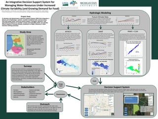
- 1. An Integrative Decision Support System for Managing Water Resources Under Increased Climate Variability (and Growing Demand for Food) Project Goal: To develop and disseminate a Decision Support System (DSS) that integrates a diverse set of hydrologic systems, models, analytical tools, and processes, that will enable water resources policy-makers, managers, planners, and agricultural producers to consider current and expanding water use and the future impacts of varying climatic conditions on water resources in their decision-making processes. Legend Distance Tools Print map Evaluate a BMP Kalamazoo River Watershed Winter Spring Summer Autumn Select Time Period: o 2030s o 2040s o 2050s o 2060s o 2070s o 2080s o 2090s Select Climate Scenario: o CCSM-a1fi o CCSM-b1 o HADCM3-a1fi o HADCM3-b1 Select Layer Name: o ET o Recharge o Stream flow o Soil Moisture o Water Table Depth o Etc…. Prairie River Watershed Legend Distance Tools Print map Evaluate a BMP Winter Spring Summer Autumn User clicks “Evaluate a BMP” User draws polygon Calculate change recharge, surface runoff, and evapotranspiration under various climate scenarios within the user- defined polygon. Current Scenario 1 Scenario 2 Current Land cover: Agriculture Selected Area Size: 40 acres Current Recharge: 12 inches/year Study Area The project is focused on southwest Michigan, an area dominated by agriculture, sandy soils, and moderate slopes. The region has a population of almost 2.5 million people (2010 U.S. Census), and its main cities are Grand Rapids (200,000) and Kalamazoo (77,000) Main Land Covers (NLCD 2006) 53% Agriculture 16% Forest 16% Urban/Suburban 12% Wetlands Hydrologic Modeling SWAT 400 450 500 550 600 650 mm/yr Year Evapotranspiration HADCM3-b1i HADCM3-A1Fi CCSM-b1i CCSM-A1Fi 200 250 300 350 400 450 500 550 600 650 700 mm/yr Year Ground Water Recharge HADCM3 b1 HADCM3 A1Fi CCSM3 b1 CCSM3 A1Fi The Soil and Water Assessment Tool (SWAT) is being used to estimate changes in ground water resources under various future climate scenarios. Initial results for the Prairie River Watershed show an increasing trend of ground water recharge, following an overall trend of increasing precipitation and, towards the end of the century, decreasing ET (resulting from higher CO2 concentrations limiting leaf conductance). Climate Scenarios Climate Scenarios Future Climate Data 800 850 900 950 1000 1050 1100 1150 1200 1250 1300 mm/yr Precipitation HADCM a1fi HADCM3-b1 CCSM-A1Fi CCSM-B1 8 9 10 11 12 13 14 15 16 17 degreesC Temperature HADCM a1fi HADCM3-b1 CCSM-A1Fi CCSM-B1 Future climate data from two models, the UK Meteorological Office Hadley Centre (HadCM3) and the National Center for Atmospheric Research (CCSM), each under two scenarios (A1fi – high CO2, B1 – moderate CO2), were downscaled and organized by Hayhoe, et al. (2010). The modeling team is feeding that data into SWAT, AFINCH, and PAWS to simulate future changes in hydrology in the study area. AFINCH AFINCH (Analysis of Flows IN CHannels) is a stepwise regression model used to estimate monthly water yields from catchments based upon geospatial-climate and land cover data in combination with available stream flow and water-use data. Monthly water-use data are employed to adjust monthly measured flows at gages downstream from flow lines of documented withdrawals or augmentations. The resulting long-term time series can be used to describe monthly flow duration characteristics and trends. Climate Scenarios 80 85 90 95 100 105 110 115 AverageAnnualFlow(cfs) Year Prairie River Stream Flow HADCM3-b1 HADCM3-A1Fi CCSM-b1 CCSM-A1Fi Decision Support System Ground Water Recharge in the Prairie River Watershed (HadCM3 – A1Fi 2050-2059) PAWS + CLM The Process-based Adaptive Watershed Simulator and Community Land Model (PAWS+CLM) uses a structured finite-volume grid to solve the governing partial differential equations for different hydrologic units (e.g. Richards equation for the vadose zone, Darcy’s equation for groundwater, diffusive wave equation for overland flow etc.). The model performance was evaluated by multiple datasets, e.g. river discharge, groundwater head and evapotranspiration. Evapotranspiration in the Prairie River Watershed Obs. vs. Sim. Ground Water Head in the Prairie River Watershed Feeds Design Input Dissemination Display Layer The outputs from the hydrological models will be fed into an on-line decision support system (DSS) where users can view water resource maps of the study area under varying climate conditions and time periods, conduct field-scale analyses, and evaluate the potential impacts of a best management practice (BMP) under those conditions. Outreach The outreach team has been networking with water users, farmers, and water-related organizations in the region to recruit prospective users of the DSS; and will empower them by promoting use of the DSS and conducting local trainings. Stakeholders - Farmers - Municipalities - Watershed groups - Local Conservation Districts - Federal and State Regulators - University Extension Professionals - Well-drillers Surveys A team of social scientists is conducting interviews and administering surveys among stakeholders in the region to discern the key socioeconomic drivers of ground water management decisions, and identify the key functional needs of prospective DSS users. Interviews have been conducted with farmers, conservation organization representatives, and others, including municipal water and community officials. Authors: Glenn O’Neil1, A. Jeremiah Asher1, Jason Piwarski1, Phanikumar Mantha2, James Duncan1, Jon Bartholic1, Stephen Gasteyer3. 1. Institute of Water Research, 2. Civil and Environmental Engineering, . Sociology Social Science; Michigan State University; Michigan.