2. An information resource about people
and places
...that combines government ...to give a picture of where we
data live
.....with local knowledge...
3. Pictures are powerful
People get pictures They don’t get
• Columns of detailed
statistics
• 60 page reports
• Jargon that makes no sense
4. Place is powerful
Where I live matters
• Unemployment, child poverty and
the quality of our environment
may seem abstract subjects at the
national level
• But personally important at the
local level
• Using maps is a way of giving
people an at-a-glance picture of
their neighbourhood – the data
they need and the issues that
matter
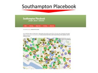
5. Southampton Placebook started with Southampton Intergenerational
Network (SIGN)and the Neighbourhoods map
1
Use the zoom to see
what groups are in a
particular area
2
Then click on the Neighbourhoods
icon to open up the map
information box
6. ...but has widened to include a range of
initiatives and resources for re-use
Initiatives (more on this later) Resources you can use
• Green economy • Neighbourhood groups
• Church lead social action • Map - Health deprivation
• OARA • Map of all places of worship
• Map of all schools
All of this data • Map of youth centres
can be mashed • Map of libraries
with data you • Wifi locations and IT
want to map training
7. Example 1: Turn a map into a Project
self-organised group activity
using a single shared online map management dashboard (SIGN map)
Icons can be colour coded
Not Active
In Partnership
Looking for a partner
G Generic - group with
young and old members
Y Young – young persons
group
Click on icons to get headline O Older persons group
information
Single shared map with multiple
authors, each editing and updating
their own details
8. Map now embedded on Southampton
Placebook as well as Southampton City Example
Council website 2
Mapping
Infra –
structure:
in this case
WiFi and
online
training
This is a public map showing online access
and training in Southampton
It involves 43 online collaborators working
asynchronously on a single shared map
It is both a useful information map for members of the public
and as baseline data to use with any area based project
9. Use the zoom to identify
neighbourhoods and
street names
Example project: to promote
digital in areas of high deprivation Switch to Satellite to
Map showing Online access and explore urban landscape
training is a public resource which
anyone can grab and recycle for
their own project
Example 3
layered maps
10. Would you like to know more?
Call me
01273 478 749
Email
compasstraininguk@gmail.com
http://compasstraining.org/