烏來Wu Lai Cherry Blossoms Season

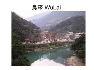
Wulai locates the most south of Taipei County with total area of 321 square kilometers and Wulai is the only hilly village. Wulai is named after its older name from Wulai organization, Urail. Its legend can be traced back 300 years ago when the native Atayal tribal people hunted at Wulai found smoking hot water gushed from river valley then yelled "Uraikirofu" urai that means steaming hot. The native used hot spring gushed from Nan-Shih Stream as their natural bath tub so hot spring in Wulai has history of 300 years. During the Japanese occupied period, the Japanese built the "Police Club" on east side of Nan-Shih Stream for the Japanese police and built public bathroom for the native to use on west side. WuLai locates at the most south of Taipei county. Geographically, it's in between the most southwest primary ridge and the northwest inclined plane of the Snow Mountain and Chia-Li Mountain ranges. Wulai locates at a higher terrain surrounds Taipei basin; approximately at 121 degrees and 33minutes east longitude and 24 degrees and 52 minutes north latitude.

Empfohlen
Weitere ähnliche Inhalte
Kürzlich hochgeladen
Kürzlich hochgeladen (20)
Empfohlen
Empfohlen (20)
烏來Wu Lai Cherry Blossoms Season
- 1. 烏來 WuLai