Google Indoor Mapping
•Als PPTX, PDF herunterladen•
2 gefällt mir•4,181 views

This document summarizes Google's indoor mapping service. It discusses how Google works with organizations to upload and align floor plans on Google Maps, determine what to label on the maps, have Google survey buildings by walking through with an app to improve location accuracy, color code sections and add icons, and work with Google to review maps before the service goes live for an organization. It also provides links to learn more and download the Google Maps Floor Plan Marker app.

Empfohlen
Weitere ähnliche Inhalte
Ähnlich wie Google Indoor Mapping
Ähnlich wie Google Indoor Mapping (20)
Mehr von St. Petersburg College
Mehr von St. Petersburg College (20)
Kürzlich hochgeladen
Kürzlich hochgeladen (20)
Google Indoor Mapping
- 2. http://www.slideshare.net/chadmairn @cmairn
- 3. The research shows … Source: http://pewinternet.org
- 4. The research shows … • As of April 2012, 55% of adult cell owners use the internet on their mobile phones; nearly double what we found three years ago. • 31% of current cell internet users say that they mostly go online using their cell phone, and not using some other device such as a desktop or laptop computer. Source: http://pewinternet.org
- 5. The research shows … Source: http://pewinternet.org
- 6. Learn more at http://goo.gl/M0Pfv
- 7. Google Indoor Maps Case Studies Visit: http://goo.gl/fZVT6 Indoor Maps availability: http://goo.gl/zvhiK More information: http://goo.gl/HPmKb
- 8. Mall of America in Minneapolis before and after, with a floor selector Source: http://goo.gl/61Cb7
- 12. The governing bodies Google has communicated with are: IAEM (International Association of Emergency Management) IACLEA (International Association of College Law Enforcement Administrators) CSHEMA (Campus Safety, Health and Environmental Management Association) IACP (International Association of Chiefs of Police)
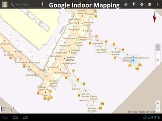
- 13. Stage 1: Uploading and aligning floor plans over satellite Google map
- 20. Stage 2: Determine what to label Champaign Public Library
- 21. Stage 3: Google Team Surveys Buildings Walks are files created with the Google Maps Floor Plan Marker application to help improve location accuracy by walking through a building and collecting relevant location information along the way. Point of interest survey to add notes to the map.
- 22. Google Maps Floor Plan Marker Download the app! http://goo.gl/2nBRh
- 23. Stage 4: Review • Color-code sections (e.g., offices could be light- blue and classrooms could be green.) • Add icons like: • Work with Google to insure building sections are labeled/not-labeled correctly before service goes live. • Google Indoor Mapping Marketing Director will help develop a press release etc.
- 24. Let’s Hangout! gplus.to/chadmairn