Beginners Guide to TikTok for Search - Rachel Pearson - We are Tilt __ Bright...
Gng Travel Dispatch Full Story
1.
Travel Dispatch: Golden Goliath Resources, Ltd. (GNG:TSX‐V)
Hunting for Gold and Silver in the Sierra Madre Occidental Mountains of Mexico
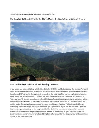
Part 1 – The Trek to Uruachic and Touring Las Bolas
A few weeks ago we were talking with Golden Goliath’s CEO, Mr. Paul Sorbara about the Company’s recent
press release and he mentioned that around the middle of the month he and his geological team would be
traveling to GNG’s Uruachic Camp property to check on the progress of the current exploration programs
being conducted at the Company’s Las Bolas and San Timoteo target areas. The Uruachic (pronounced
“oora‐wa’‐chee”) Camp is comprised of at least 6 individual targets in close proximity to each other within a
roughly 15 km x 25 km area located deep within in the Sierra Madre mountains of Chihuahua, Mexico –
making up the Company’s flagship group of precious metal targets. We told Paul that sounded like an
interesting adventure and picking up on the hint he quickly invited us to join him and his team. We have
been watching and reporting on the progress at Golden Goliath for some time now, so when we were
offered the chance to visit the property in person, we saw an opportunity to get a firsthand look at this
junior explorer’s primary mineral targets and bring back a full account of the property tour and exploration
activity to our subscriber base.
6. of the old shafts. If found, this will be some very valuable rock worth approx. $60,000 per cubic meter!
(assuming $12 per ounce silver and roughly 2.5 tonnes per cubic meter).
To get to this prospect area, we took the main road, which actually fords a river in several places before you
get to the other side and then up and over a winding mountain road, which took us up to a fairly high
lookout point and then up and over the other side. Once over to the other side of the ridge, the surrounding
terrain is a moderately sloping hillside covered with small trees,
Manzanita and shrubs. This hillside slopes downhill a mile or
two and ends at the fairly good sized Rio Uruachic river at the
base of the canyon which runs all the way to the Pacific Ocean.
On the other side of the Rio Uruachic, the ground slopes up
steeply, forming the next ridge line of mountains, which we
were looking directly across at, which are covered in green
foliage. In fact there has been so much rain this season, the area
is the greenest that anyone from the team could remember.
Our first stop on this side of the Camp was the Frijolar I tunnel (with a brief stop at the Frijolar II zone which
had been graded out recently). The Frijolar I tunnel is a historic mine adit which GNG is in the process of
shoring up for additional sample testing. As the ground was fairly
wet, (there had been a small slide of material around the entrance),
we opted not to enter the tunnel but examined the geology around
the perimeter of the tunnel that had been exposed by one of GNG’s
Cats (GNG maintains two Caterpillar D‐7’s on the project, which are
powerful work horses for grading access roads and leveling drill
sites while at the same time are nimble enough to navigate the
steep terrain in the area). The target areas are quite striking in the
absence of plant life and the exposed rock exhibited high levels of
manganese staining, a condition which indicates base and precious
metal anomalies. After a brief stop at Frijolar, we continued the tour down to the el Manto mine area, which
was lower on down the slope and is where the majority of drilling is now taking place. At the end of a newly
cut road we arrived at Drill hole B‐DD‐08‐15, where a diamond drill crew has been working around the clock
bringing up core which has the team in high anticipation mode. Drill core 15 was the drill bore that was
currently in work, but the core that had created all the excitement was diamond drill hole B‐DD‐08‐13,
which had intersected a 6 meter thick section that looked very similar visually to 15 cm (about 6 inches) in B‐
DD‐08‐03 that came back from the lab at 9.87
grams/tonne gold and 3,090 grams per tonne silver.
Golden Goliath’s geology team has no way of knowing how
this new 6 meter section would test out until all assays are
back from the lab, but with many similarities between the
two samples visually (the core is a very black, tar type
consistency with visible flakes of very shiny gold and silver
bearing pyrite mineralization), they are hopeful that this
thicker manto section will show a higher mineralization
value across a much thicker section of rock.
7.
After kicking around the core shack for about 45 minutes inspecting samples of core with geologists loupes
(a small hand held magnifier), we loaded up and headed for our next stop, the Arbolito shaft. The Arbolito
shaft is elephant country at Uruachic Camp, with the highest grade
mineralization to date found in one of the ore dumps located just down
slope from this deep historical mining shaft. Golden Goliath had been
conducting physical sampling of this shaft in the recent past, which
runs several hundred feet
nearly straight down from the
surface, until a good sized cave‐
in convinced management that
this was too dangerous and curtailed that activity before a serious
accident occurred and someone got hurt.
Since that time, Golden Goliath has been exploring this target from
the surface by drilling. That method has proved problematic as well
as two different drill holes have been stopped short of their target depth by difficult drilling conditions.
Golden Goliath has put this target on hold for the past few
months, but with the manto subfloor now located several
hundred meters down slope, they plan to drill several new
(diamond drill) holes (with a more experienced drill crew and
better equipment) in this section to the target depth of the
manto to hopefully confirm the continuity of the structure.
Golden Goliath is cautiously optimistic that the intersection of the
arbolito shaft and the manto could be the zone they have been
looking for in this region that is host to some of the super high
grade material they have seen in dumps in the area (71,000 + grams per tonne silver). After our stop at
Arbolito, we loaded up both trucks and headed back to the town of Uruachic for some lunch but on our way
back got stuck for about half an hour by a water truck coming up from town to deliver water to the drilling
rig over in the el Manto target.
12. As the San Martin tunnel runs almost a full kilometer into the
hillside, I was somewhat relieved when Paul casually stated that
since we were on the core shack side of the river, that we would
not be going into the San Martin tunnel that afternoon. I had
been sweating that situation all day, and was wondering what I
was going to do when faced with the decision of going deep into
the hillside in a tunnel that was easily over 100 years old –
thankfully I never had to make that decision.
The San Martin tunnel area has been extensively explored by
Golden Goliath with recent findings that are very prospective for
defining a large volume area with precious metal values. Recent assay results include a number of excellent
findings. In April of 2008, the Company announced results including underground chip sampling that
returned a 40 metre section grading 1.95 gm gold/tonne and 56.8 gm silver/tonne, including a 10 metre
section grading 6.7 gm gold/tonne and 131.6 gm silver/tonne. That section was located approximately 250
metres from the entrance to the tunnel in an area that contains old cross cuts, raises and an internal shaft.
In May of 2008 they bettered those
results with grab samples from a new
zone that averaged 6.8 gm gold/tonne
and 2,158 gm silver/tonne. From these
results the Company was now starting
to zero in on three separate areas in
the San Martin tunnel region that were
identified as Zones A, B and C. The
following text summarized these three
zones:
Zone A begins approximately 209
metres from the tunnel entrance. In
addition to the above results, drill hole
ST‐DD‐08‐7, which undercut the tunnel
about 100 metres from the entrance,
returned a weighted average of 1.74 gm gold/tonne over 7.75 metres. This
further expands the overall zone of gold mineralization by an additional 100
metres.
Zone B opens in 3 directions (North, South and vertically) whereas Zone C
opens to the South and vertically.
Both Zones B and C have high grade sections. Zone B has a 10 metre section
grading of 6.7 gm gold/tonne and 131.6 gm silver/tonne (reported on April 8). Zone C returned 3 grab
sample assays averaging 6.8 gm gold/tonne and 2,158 gm silver/tonne. Zones B and C are part of Zone A.
Upon examining the core samples from the most recent sections of the current diamond drill location, it
looked as if Golden Goliath was continuing to close in on the higher grade material. The cores were
14. Goliath’s ASTER study delineated some highly altered zones & important mineral spectra that were similar
to the Carlin Trend Deposits (in Nevada) and other large hydrothermal systems. We were headed to one of
those zones right now. Upon our arrival, (after very nearly high centering one of the trucks in a very deep
drywash ‐ that turned out to be not so dry) the
team sized up the area and after taking a few
ground samples penciled in several potential drill
pad sites on the map that would be further
evaluated before final selections would be made.
The brisk conversation revolving around this
exciting new target wound down after a while to
a somber silence as the sun dipped below the
high ridge of the San Timoteo hillside, bathing
the entire valley in the soft golden glow of
twilight. Without a word, each of us knew
instinctively that our day in the field had come to
an end and it was time to head back to the barn.
We loaded up again for the rough ride back over the mountain and a much deserved dinner (we hadn’t
eaten much since breakfast, so the crew was getting pretty hungry at this point) as well as a recap of the
day’s events back at Golden Goliath’s Uruachic office.
The Long Trip Home
After about 45 minutes on the winding dirt road back to Uruachic, passing the humble brick casas and out
buildings of the native Uruachic farmers that live in the remote outskirts of town, we arrived back at GNG’s
field office. Notes of the day’s events were organized, rock samples were tagged and recorded, and after a
brief consultation of area maps, we all walked back into town (somewhat reminiscent of the opening scene
of the Tarantino classic ‐ Reservoir Dogs) for our final dinner feast at Margarita’s restaurant. With everyone
tired from the long day in the field, we retired early and I slipped into a very deep and peaceful sleep,
broken just before daylight by the many roosters of Uruachic that take their
task of waking the town each morning very seriously. After a quick breakfast
and the standard good bye’s to new friends at Golden Goliath’s office, Omar
and I took our leave and started the long journey back to Chihuahua, which
was really much more like time travel, turning the clock forward about 50
years in eight hours while returning to the 21st century. In many ways, the
trip home was very much like the trip there, only in reverse order – stopping
at the same places for gas, eating at the same restaurant . . watching the
same roadside attractions go by from the other side of the truck – except we
made one side trip to a famous waterfall. I have since forgotten the name
of the waterfall, which doesn’t matter really. We were the only ones there
that day , which was rather odd as this waterfall is one of the highest in
North America and was truly a magnificent site – giving testament as to just
how remote this area really is.
We made good time back to Chihuahua and before I knew it Omar was dropping me off at the Hampton Inn
for one more night in‐county as I wasn’t flying back to San Diego until the following morning. After a brief