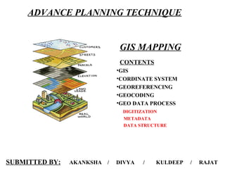
2. What is a GIS?
GEOGRAPHIC
implies that locations of the data items are known, or can be calculated, in terms of Geographic
coordinates (Latitude, Longitude)
INFORMATION
implies that the data in a GIS are organized to yield useful knowledge, often as colored maps
and images, but also as statistical graphics, tables, and various on-screen responses to
interactive queries.
SYSTEM
implies that a GIS is made up from several inter-related and linked components with different
functions. Thus, GIS have functional capabilities for data capture, input, manipulation,
transformation, visualization, combinations, query, analysis, modelling and output.
• GIS = Geographic Information System
– Links databases and maps
– Manages information about places
– Helps answer questions such as:
• Where is it?
• What else is nearby?
• Where is the highest concentration of ‘X’?
• Where can I find things with characteristic ‘Y’?
3. What is a GIS?
• A technology
– hardware & software tools
• An information handling strategy
• The objective: to improve overall decision making
“A system for capturing, storing, checking, integrating, manipulating, analysing and
displaying data which are spatially referenced to the Earth. This is normally considered to
involve a spatially referenced computer database and appropriate applications software”
4. Why GIS is unique ?
• GIS handles SPATIAL
information– Information referenced
by its location in space
• GIS makes connections between
activities based on spatial
proximity
5. A GIS integrates spatial and other kinds of information within a single system to provide a
consistent framework for analyzing geographic (spatial) data.
Why GIS is unique ?
A set of tools for
Collecting Storing Manipulating Retrieving Transforming Display of Spatial
Data from the Real
World
6. Capture
Data
GIS PROCESS
Register
Map Base
Interpret
Data
Convert Data
to Digital
Format
Store Data
in Computer
Process
Data
Display
Results
SpatialSpatial
DataData
BaseBase
AttributeAttribute
DataData
BaseBase
CartographicCartographic
Display SystemDisplay System
Geographic
Analysis
System
MapMap
DigitizingDigitizing
SystemSystem
ImageImage
ProcessingProcessing
SystemSystem
StatisticalStatistical
AnalysisAnalysis
SystemSystem
DatabaseDatabase
ManagementManagement
SystemSystem
ImagesImages
MapsMaps
MapsMaps
StatisticalStatistical
ReportsReports
StatisticsStatistics
Tabular DataTabular Data
GIS SYSTEM
GIS areas
Geo Sciences
Civil EngineeringTransportation
Natural resources
Geology & Environment
Urban & Rural Development
Floods , Disasters Oil exploration
Remote Sensing Image processing
Mines Surveys
Watershed management
Tourism Communications
7. Coordinate system
Coordinate systems enable geographic datasets to use common
locations for integration. It is a reference system used to represent the
locations of geographic features, imagery, and observations, such as
Global Positioning System (GPS) locations, within a common
geographic framework.
• Spatial data are generally recorded as latitude & longitude,
frequently as decimal degrees.
• Other systems used are the Universal Transverse Mercator - UTM & State Plane Coordinates. Which are projections of the curved surface of the globe on to a plane surface.
• UTM system unit is the meter and State plane system unit is the foot.
• In the UTM system projections area made in zones of approximately 6 degrees of longitude.
Geographic Coordinate System
A geographic coordinate system (GCS) uses a three-dimensional spherical surface to define
locations on the earth. A GCS is called a datum, but a datum is only one part of a GCS.
• A GCS includes an angular unit of measure, a prime meridian, and a datum (based on
a spheroid). The spheroid defines the size and shape of the earth model, while the datum
connects the spheroid to the earth's surface.
• A point is referenced by its longitude & latitude values.which are the
angles measured from the earth's center to a point on the earth's surface.
The angles often are measured in degrees (or in grads)
8. • The line of latitude midway between the poles is called the equator. It defines the line of zero
latitude. The line of zero longitude is called the prime meridian. For most GCSs, the prime meridian
is the longitude that passes through Greenwich, England.
• Latitude & longitude values are measured either in decimal degrees or in degrees, minutes, and
seconds (DMS). Latitude values are measured relative to the equator and range from –90° at the
south pole to +90° at the north pole. Longitude values are measured relative to the prime
meridian. They range from –180° when traveling west to 180° when traveling east. If the prime
meridian is at Greenwich, then Australia, which is south of the equator and east of Greenwich, has
positive longitude values and negative latitude values
• It may be helpful to equate longitude values with x and latitude values with y. Data defined on a
geographic coordinate system is displayed as if a degree is a linear unit of measure. A physical
location will usually have different coordinate values in different geographic coordinate systems.
Geographic Coordinate System
Projected coordinate systems
A projected coordinate system (PCS) is defined on a flat, two-dimensional surface. Unlike a GCS,
a PCS has constant lengths, angles, and areas across the two dimensions. A PCS is always based on a
GCS that is based on a sphere or spheroid. In addition to the GCS, a PCS includes a map projection, a
set of projection parameters that customize the map projection for a particular location, and a linear unit
of measure.
9. Map projections
Whether you treat the earth as a sphere or a spheroid, you
must transform its three-dimensional surface to create a flat
map sheet. This mathematical transformation is commonly
referred to as a map projection. One easy way to understand
how map projections alter spatial properties is to visualize
shining a light through the earth onto a surface, called the
projection surface
• Wrap a piece of paper around the earth.
• A light at the center of the earth will cast the shadows of the graticule onto the piece of paper. You
can now unwrap the paper and lay it flat.
• The shape of the graticule on the flat paper is different from that on the earth. The map projection
has distorted the graticule.
•A spheroid cannot be flattened to a plane any more easily than a piece of orange peel can be
flattened—it will tear. Representing the earth's surface in two dimensions causes distortion in the
shape, area, distance, or direction of the data.
•Different projections cause different types of distortions. Some projections are designed to minimize
the distortion of one or two of the data's characteristics. A projection could maintain the area of a
feature but alter its shape. In the following illustration, data near the poles is stretched:
•A map projection uses mathematical formulas to relate spherical coordinates on the globe to flat,
planar coordinates.
10. Projection parameters
A map projection by itself is not enough to define a PCS. You can state that a dataset is in Transverse
Mercator, but that's not enough information.
•Where is the center of the projection?
•Was a scale factor used?
•Without knowing the exact values for the projection parameters, the dataset cannot be reprojected.
You can also get some idea of the amount of distortion the projection has added to the data.
•If you're interested in Australia but you know that a dataset's projection is centered at 0,0, the
intersection of the equator and the Greenwich prime meridian, you might want to think about changing
the center of the projection.
•Each map projection has a set of parameters that you must define. The parameters specify the origin and
customize a projection for your area of interest. Angular parameters use the GCS units, while linear
parameters use the PCS units.
11. • False easting is a linear value applied to the origin of the x-coordinates. False northing is a linear value
applied to the origin of the y-coordinates.
False easting and northing values are usually applied to ensure that all x- and y- values are positive. You
can also use the false easting and northing parameters to reduce the range of the x- or y- coordinate
values. For example, if you know all y- values are greater than 5,000,000 meters, you could apply a false
northing of –5,000,000
• Height defines the point of perspective above the surface of the sphere or spheroid for the Vertical Near-
Side Perspective projection.
LINEAR PARAMETRES
ANGULAR PARAMETRES
• Azimuth defines the centerline of a projection. The rotation angle measures east from north. It is used
with the azimuth cases of the Hotine Oblique Mercator projection.
• Central meridian defines the origin of the x-coordinates.
• Longitude of origin defines the origin of the x-coordinates. The central meridian and longitude of origin
parameters are synonymous.
• Central parallel defines the origin of the y-coordinates.
• Latitude of origin defines the origin of the y-coordinates. This parameter may not be located at the center
of the projection. In particular, conic projections use this parameter to set the origin of the y-coordinates
below the area of interest. In that instance, you do not need to set a false northing parameter to ensure
that all y- coordinates are positive.
12. UNITLESS PARAMETERS
A vertical coordinate system defines the origin for height or depth values. Like a horizontal coordinate
system, most of the information in a vertical coordinate system is not needed unless you want to
display or combine a dataset with other data that uses a different vertical coordinate system.
•Perhaps the most important part of a vertical coordinate system is its unit of measure. The unit of
measure is always linear (for example, international feet or meters). Another important part is whether
the z-values represent heights (elevations) or depths. For each type, the z-axis direction is positive
"up" or "down," respectively.
VERTICAL CORDINATE SYSTEM
• Scale factor is a unitless value applied to the center point or centerline of a map projection. The
scale factor is usually slightly less than one. The UTM coordinate system, which uses the
Transverse Mercator projection, has a scale factor of 0.9996 Rather than 1.0, the scale along the
central meridian of the projection is 0.9996.
• X and y scales are used in the Koryak projection to orient the axes.
• Option is used in the Cube and Fuller projections. In the Cube projection, option defines the
location of the polar facets. An option of 0 in the Fuller projection displays all 20 facets.
Specifying an option value between 1 and 20 displays a single facet.
13. 1) A georeferenced may be unique only within a defined domain, not globally
2) There are many instances of Springfield in the U.S., but only one in any state
3) The meaning of a reference to London may depend on context, since there are smaller London's in
several parts of the world.
GEOREFERNCING
• To georeferenced’ the act of assigning locations to
atoms of information Is essential in GIS, since all
information must be linked to the Earth’s surface
UNIQUENESS:-
The method of georeferencing must be:
•Unique, linking information to exactly one location
•Shared, different users understand the meaning of a georeferenced
•Persistent through time, so today’s georeferenced are still
meaningful tomorrow
METRIC REFERENCES:-
• Essential to the making of maps and the display of mapped information in GIS
• Provide the potential for infinitely fine spatial resolution (provided we have sufficiently accurate
measuring devices)
• From measurements of two or three locations it is possible to compute distances.
14. LINEAR REFERNCING
• A system for georeferencing positions on a road, street, rail, or
river network
• Is closely related to street address but uses an explicit measurement of
distance rather then the much less reliable surrogate of street address
number
Transportation authorities To keep track of pavement quality, signs, traffic conditions on
roads Police To record the locations of accidents
USERS OF LINEAR REFERNCING
PROBLEM CASES
• Locations in rural areas may be a long way from an intersection or other suitable zero point
• Pairs of streets may intersect more than once
• Measurements of distance along streets may be inaccurate, depending on the measuring device, e.g. a car odometer
CADASTRAL MAPS:-
• Defined as the map of land ownership in an area, maintained for the purposes of taxing land, or of
creating a public record of ownership
• Parcels of land
– Are uniquely identified by number or code (PIN)
– Are reasonably persistent through time, but
15. LATITUDE AND LONGITUDE
The most comprehensive and powerful method of georeferencing
• Provides potential for very fine spatial resolution
• Allows distance to be computed between pairs of locations
• Supports other forms of spatial analysis
• Uses a well-defined and fixed reference frame
• Based on the Earth’s rotation and center of mass, and the
Greenwich Meridian
Latitude:
It is the angular distance, in degrees, minutes, and seconds
of a point north or south of the Equator. Lines of latitude are
often referred to as parallels.
Longitude:
It is the angular distance, in degrees, minutes, and seconds,
of a point east or west of the Prime (Greenwich) Meridian.
Lines of longitude are often referred to as meridians.
16. GEOCODING
(sometimes called forward geocoding) is the process of
enriching a description of a location, most typically a postal
address or place name, with geographic coordinates from
spatial reference data such as building polygons, land
parcels, addresses, ZIP codes (postal codes) and so on.
• Reverse geocoding is the process of enriching geographic
coordinates with a description of the location, most typically a
postal address or place name.
It is the process of transforming a description of a location—
such as a pair of coordinates, an address, or a name of a place—
to a location on the earth's surface.
You can geocode by entering one location description at a time
or by providing many of them at once in a table. The resulting
locations are output as geographic features with attributes,
which can be used for mapping or spatial analysis.
• A geocoder is a piece of software or a (web) service that implements a geocoding process.
Geocoding facilitates spatial analysis using Geographic
Information Systems and Enterprise Location
Intelligence systems.
17. What can geocoding be used for?.
• You can also display your address information based on certain parameters, allowing
you to further analyze the information.
• A few of these applications are described in the sections that follow.
•From simple data analysis to business and customer
management to distribution techniques, there is a wide
range of applications for which geocoding can be
used.
•With geocoded addresses, you can spatially display
the address locations and recognize patterns within the
information.
•This can be done by simply looking at the
information or using some of the analysis tools
available with ArcGIS.
.
18. DIFFERENCE BETWEEN GEOREFERENCING AND GEOCODING
• In some online mapping service, you may have seen satellite imagery. When these images are
captured from a satellite or an airplane, they are just plain images, like photographs. But to
display these images on a map, they need to be associated with map coordinates. This process is
called GeoReferencing.
• Once the image is associated with the map coordinates it can be overlaid on top of street maps. For
georeferencing, you can use a GIS software such as ArcGIS or QGIS to georeference an
otherwise un-referenced image or scanned maps, and load them into Oracle Spatial.
• Geocoding is the process of taking coded location information (such as addresses or grids) and
turning it into explicit location information (X and Y coordinates, usually). Reverse
geocoding is the opposite, taking XY data and locating the nearest address, grid, etc.
• When you type an address or a placename in the searchbox and in return the map shows a marker at
the place. The process of associating an address or a placename with coordinates on the map is
called Geocoding. In a spatial database this is done as a point layer with name of the place as an
attribute to the point location. This is one way of geocoding.
• For addresses, the associated coordinates are not saved in a database directly, but computed
using a method called linear referencing. (Thus the confusion between the terms geo-
referencing and linear-referencing ) The start and end addresses along a line segment are saved and
intermediate addresses are interpolated and the coordinates are calculated.
19. GIS DATA PROCESSING
Why digitize?
1. New maps
2. Map features are wrong
3. Missing features
4. Other?
Heads down digitizing
Steps for heads down digitizing
Tape map to the digitizer
Register control points on the map
Estimate two conversion equations (one for
vertical and one for horizontal coordinates)
Digitize vectors (points, lines, or polygons)
Puck
Tap
e
Control points
Map
Digitizing tablets
• Used to digitize hard copy maps into GIS
• Transform wire intersections into coordinates of the tablet’s coordinate system
DIGITIZING OVERVIEW
20. GIS DATA PROCESSING DIGITIZING FEATURES
Heads up digitizing
Mouse on a screen
Digitizes paper maps, aerial photos, or other images
Create new feature class
Created in ArcCatalog
21. GIS DATA PROCESSING DIGITIZING FEATURES
Create new feature class
Add spatial reference information Add new fields
22. GIS DATA PROCESSING DIGITIZING FEATURES
Create new feature class
Feature class created
Creating Feature Layers or Shapefiles in ArcMap
Locate an existing data layer that is similar to the layer that you wish to create.
Start editing the existing layer, then digitize the new feature
Select the new feature
Export the selection to a shapefile
Add the shapefile- fields already present and map projection is already defined
23. DIGITIZES NEW FEATURES
Create base map
Add feature in ArcMap
Start editing (Editor toolbar)
Digitize feature
Stop editing and save
Create base map for digitizing
Vector features or raster images
Add new features class
24. Editor, Start editing
Add Editor tool bar
• Customize, Toolbars, Editor toolbar
Start Editing
• Begin digitizing • Click point (tree) locations
25. Start editing, populate fields in table
Add Editor tool bar
• Editor, Stop editing
Edit attribute data
DIGITIZING SOURCES
USGS
• Digital Elevation Models (DEMs)
• Digital Orthophoto Quads(DOQQs)
• Digital Line Graphs(DLGs)
• Digital Raster Graphics (DRGs)
• Landsat Satellite Images
• Land Use Land Cover (LULC)
• Spatial Data Transfer Standard(SDTS)
United States Geological Survey
26. ORTHOPHOTOGRAPHY
Digital imagery in which distortion from
the camera angle and topography have
been removed, thus equalizing the
distances represented on the image
GIS TUTORIAL 1 - Basic Workbook
DIGITAL ORTHO QUARTER QUADS—DOQQs
• Grayscale or color-infrared (CIR) images
• 1-meter ground resolution;
• Cover an area measuring 3.75 minutes longitude by 3.75 minutes latitude, approx. 5 miles
on each side
• Referenced to the North American Datum of 1983 (NAD83) and cast on the Universal
Transverse Mercator (UTM) projection
• The ground length of one pixel of the image with one meter resolution means that each
pixel in the image represents one square meter on the ground.
30 meters 10 meters 5 meters 2 meters 1 meter
27. NATIONAL ELEVATION DATA SETS
• United States Geological Survey (USGS) National Elevation Dataset (NED)
Shaded Relief Imagery Data (Free)
• Maps provide highest-resolution elevation data available across the United States,
in raster format
SCANNING PAPER DOCUMENTS
Raster to vector conversion
Paper (historic) maps
Scanned maps and images become vectors
Special software needed
28. METADATA
What is Metadata:
– Data about data
What is Meant by Data?
– Broad sense: any information
resource or object
– Here: geospatial data, in digital
format
Familiar Metadata for Geospatial Data
•A Map Legend
–Who made the map
–Date of Map (reference date)
–Scale of the map
–Description
Geospatial Metadata
“...data about spatial data...”
• identifies and describes datasets, coverages, images, etc
• provides information about data quality, lineage, source materials, spatial
reference, subject themes
• contains the “data dictionary” defining attributes and relationships
29. ESRI is realizing a vision of global data sharing by creating technology to support
metadata. Metadata makes spatial information more useful to all types of users by
making it easier to document and locate data sets. The growing availability of data of
all kinds from many different sources has helped GIS technology become more
useful and widely adopted. With metadata support, data producers can publish
information about data, and data consumers can search for the data they need.
Because spatial data is the fuel of a GIS, it is important to know if the data will meet
user needs. Data users need metadata to locate appropriate data sets. Metadata
provides information about the data available within an organization or from catalog
services, clearinghouses, or other external sources. Metadata not only helps find data,
but once data has been found, it also tells how to interpret and use data. Publishing
metadata facilitates data sharing. Sharing data between organizations stimulates
cooperation and a coordinated, integrated approach to spatially related policy issues.
Why Is Metadata Important to GIS?
30. Keeping spatial metadata records is important. From a data management perspective,
metadata is important for maintaining an organization's investment in spatial data.
Metadata benefits an organization in the following ways:
Metadata And GIS Management
• Provides an inventory of data assets
• Helps determine and maintain the value of data
• Helps you determine the reliability and currency of data
• Supports decision making
• Documents legal issues
• „Helps keep data accurate and helps verify accuracy to support good decision
making and cost savings
• „Helps determine budgets because it provides a clearer understanding of when
or if data needs to be updated or repurchased
31. METADATA
Simple Metadata for Geospatial Data
Originator: REGIS, UC Berkeley
Title: Roads in Alameda County
Date Created: 10/20/97
Ground Date: 11/06/94
Filename: rds197.shp
Filesize: 1MB
Fileformat: ArcView Shapefile
Source Scale: 1:24K
Projection/Coordinate Info: UTM Zone 10
Objectives for Metadata
• Identification - inventory data
holdings; facilitate
browsing/searching for relevant
information
• Evaluation - determining “fitness
for use” based on application
requirements
• Interpretation - extracting and
utilizing data correctly in terms of
schema, accuracy/ precision,
reference
32. METADATA
Simple Metadata for Geospatial Data
Originator: REGIS, UC Berkeley
Title: Roads in Alameda County
Date Created: 10/20/97
Ground Date: 11/06/94
Filename: rds197.shp
Objectives for Metadata
• Identification - inventory data holdings; facilitate browsing/searching for
relevant information
• Evaluation - determining “fitness for use” based on application requirements
• Interpretation - extracting and utilizing data correctly in terms of schema,
accuracy/ precision, reference
Simple Metadata for Geospatial Data
Filesize: 1MB
Fileformat: ArcView Shapefile
Source Scale: 1:24K
Projection/Coordinate Info: UT Zone 10
33. Why Create / Use Metadata?
• GIS data expensive to create. Want to protect that investment.
• Large organizations that create/use GIS data have greatest stake in creating / obtaining metadata.
• The biggest of these organizations is the US Government. Recognizing the need to promote coordinated development, use, sharing,
and dissemination of geospatial data, the Federal Geographic Data Committee (FGDC) was formed in 1990.
The Data Creator:
Create metadata to document data; to record data processing information; to facilitate re-use of
data
The Data Manager:
• Wants to know what data has been created and how.
• Wants an inventory of existing data (to avoid costly duplication, to advertise, to promote)
• Wants documentation of data to facilitate re-use.
The Data Seeker:
• Metadata provides text fields and info that can be searched
• Metadata helps evaluate usefulness of / quality of data found
STANDARDIZING METADATA
34. The FGDC - Federal Geographic Data Committee
• An organization of representatives from 16 Federal agencies (DOA, DOC, DOD, EPA,
FEMA, HUD, LOC, NASA, ..)
• Works in cooperation with organizations from state, local and tribal governments, the
academic community, and the private sector
• Coordinates the development of the National Spatial Data Infrastructure (NSDI).
The NSDI - National Spatial Data Infrastructure
Policies, standards, and procedures for organizations to cooperatively produce and share geographic data. The 16 federal agencies that
make up the FGDC are developing the NSDI in cooperation.
Recognition at the highest level of the importance of geospatial data
.
The FGDC and Metadata
Recognized the need for formal metadata. From 1992 - 1994 FGDC worked on metadata
issues and developed a standard by which geospatial metadata should be documented.
The FGDC Content Standard for Digital Geospatial Metadata
• The CSDGM
35. FGDC Metadata
• Defined by Executive Order 12906 in April 1994 as formal format for Federal use
• To be applied to all new federal data sets, effective January 1995; all legacy data on a
schedule
• Current Version: CSDGM Version 2 - 1998
What’s in the FGDC Metadata Standard?
• The standard establishes a common set of terminology and definitions for concepts related
to metadata, including:
– the names of data elements to be use (e.g. title, originator, progress,..)
– definitions of these elements (progress=state of data set)
– Information about valid values for these elements (progress = completed or in work
or planned)
• The standard contains approximately 300 data elements, many of which can be repeated.
(multiple keywords for example), that are organized into 7 main sections.
36. The 7 Sections of the CSDGM:
• Identification:
– Title, Extent, Purpose/Abstract, Keywords, Correctness, Use Restrictions
• Data Quality:
– Accuracy, Completeness, Lineage, Source Materials
• Spatial Data Organization:
– Point, Vector, or Raster data
• Spatial Reference:
– Coordinate System, Projection Information
• Entity and Attribute Information:
– Features, Attributes, Possible Attribute Values (data dictionary)
• Distribution Information:
– How to obtain data, formats available, fees
• Reference:
– Who made the metadata record? In accordance with what standard?
37. FGDC Metadata Standard
• The size of the FGDC Metadata Content Standard reflects the diversity of the
users of the Standard (different users have different needs for documenting their
datasets).
• Only Sections 1 and 7 need to be completed in order to have a metadata record
that meets the minimum FGDC metadata standard requirements.
What the FGDC Metadata Standard Does:
Details a format for creating a metadata record for a geospatial data set.
What it Doesn’t Do:
–Doesn't specify how to collect metadata or organize your metadata
–Doesn't impose a standard for data storage or transfer
–Doesn't specify how to present or communicate metadata
38. Why Should you care about the CSDGM?
if you want to use or participate in the NSDI
as a method for learning about metadata
soon to be a ISO standard
more and more automated / commercial metadata tools implement this standard (e.g.,
ArcInfo document.aml)
Should you implement it if you do Metadata?
–What are the alternatives?
–Cost / benefit analysis
• Can you afford to?
• Can you afford not too?
How to implement it if you choose to?
–Tools and information
• See the FGDC website
• Existing free software tools too specific or too general
• Commercial software is available
40. GIS Data Formats There are two formats used by GIS systems to store and retrieve geographical data
Raster Format
• Data are divided into cell, pixels, or elements
• Cells are organized in arrays
• Each cell has a single value
• Row and Column Numbers are used to identify
the location of the cell within the array.
• Perhaps the most common example of raster
data is a digital image.
Vector Format
• Data are associated with points, lines, or boundaries
enclosing areas
• Points are located by coordinates
• Lines are described by a series of connecting vectors
(line segments described by the coordinates of the
start of the vector, its direction, and magnitude or
length).
• Areas or polygons are described by a series of
vectors enclosing the area.
GIS DATA PROCESSING
Vector and Raster Formats
• Most GIS software can display both vector and raster data.
• Raster formats are efficient when comparing information among arrays with the same cell size.
• Raster files are generally very large because each cell occupies a separate line of data.
• Vector formats are efficient when comparing info. whose geographical dimensions are different.
Most GIS software can display both raster and vector data. Only a limited number of
programs can analyze both types of data or make raster type analyses in vector formats.
42. Vector and Raster Representation
Map Feature GIS Vector Format GIS Raster Format
(X,Y)
Coordinate in space
Cell Located in an Arr
Point Map Features
Line Map Features
Area Map Features
o Road
o Stream
o Railway
o Tree
o Traffic accident
o Lamp post
o Lake
o Soil type
43. COMPARISON
• Raster formats are efficient when comparing
information among arrays with the same cell
size.
• Raster files are generally very large because
each cell occupies a separate line of data, only
one attribute can be assigned to each cell, and
cell sizes are relatively small.
• Raster representations are relatively coarse
and imprecise
• Vector formats are efficient when comparing
information whose geographical shapes and sizes a
different.
• Vector files are much smaller because a relatively
small number of vectors can precisely describe lar
areas and a many attributes can be ascribed to thes
areas.
• Vector representations of shapes can be very preci
RasterRaster VectorVector
44. Digital data
Maps and
Plans
Paper files
Photogrammetry
Remote Sensing Field survey
Interviews
GIS Data Sources
Data
Data
Data
Data
GIS
Hinweis der Redaktion
This is a clipped portion of the SE quadrant of Lombard, IL. Projection:UTM (16N), NAD83
Source date: 17-APR-98