Open data workshop intro
•Als DOCX, PDF herunterladen•
0 gefällt mir•466 views

Map making in appropriate projections in FOSS and COTS Antarctic (QGIS) and Arctic (ArcGIS Pro & Online) examples

Empfohlen
Weitere ähnliche Inhalte
Mehr von Andrew Zolnai
Mehr von Andrew Zolnai (20)
Kürzlich hochgeladen
Kürzlich hochgeladen (20)
Open data workshop intro
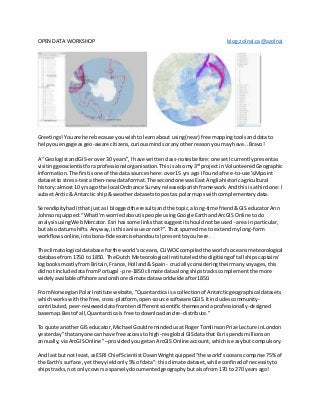
- 1. OPEN DATA WORKSHOP blog.zolnai.ca@azolnai Greetings!Youare here because youwishtolearnabout using(near) free mappingtoolsanddatato helpyou engage asgeo-aware citizens,curiousmindsoranyotherreasonyoumay have…Bravo! A “GeologistandGIS-erover30 years”,I have writtenclass-notesbefore:one setIcurrentlypresentas visitinggeoscientistforaprofessional organisation.Thisisalsomy3rd projectinVolunteeredGeographic Information.The firstisone of the data sourceshere:over15 yrs ago I founda free-to-use¼Mpoint datasetto stress-testathen-newdataformat.The secondone wasEast Angliahistoricagricultural history:almost10 yrs ago the local Ordnance Surveyreleasedparishframework.Andthisisathirdone:I subsetArctic& Antarctic ship& weatherdatasetstopostas polarmaps withcomplementarydata. Serendipityhaditthatjust as I bloggedthe resultsandthe topic,along-time friend&GIS educatorAnn Johnsonquipped:“WhatI'mworriedaboutispeople usingGoogle EarthandArcGIS Online todo analysisusingWebMercator.Esri has some linksthatsuggestitshouldnotbe used - area in particular, but alsodatumshifts.Anyway,isthisanissue ornot?”.That spurredme to extendmylong-form workflowsonline,intobona-fideexercisehandoutsIpresenttoyouhere. The climatological database forthe world’soceans, CLIWOCcompiledthe world’soceansmeteorological database from1750 to 1850. The Dutch Meteorological Institute ledthe digitisingof tall shipscaptains' logbooksmostlyfromBritain,France,Holland&Spain - cruciallyconsideringtheirmanyvoyages,this didnot include datafromPortugal - pre-1850 climate dataalongshipstracks complementthe more widelyavailableoffshore andonshore climatedataworldwide after1850. From NorwegianPolarInstitute website,"Quantarcticaisa collectionof Antarcticgeographicaldatasets whichworkswiththe free,cross-platform, open-source softwareQGIS.Itincludescommunity- contributed,peer-revieweddatafromtendifferentscientificthemesandaprofessionally-designed basemap.Bestof all,Quantarcticais free todownloadandre-distribute." To quote anotherGIS educator, Michael GouldremindedusatRogerTomlinsonPrize Lecture inLondon yesterday"thatanyone canhave free accessto high-resglobal GISdatathat Esri spendsmillionson annually,viaArcGISOnline" –providedyougetanArcGIS Online account,whichiseasybutcompulsory. Andlast butnot least,asESRI Chief Scientist DawnWrightquipped“the world'soceanscomprise 75%of the Earth's surface,yettheyyieldonly5% of data”: thisclimate dataset,while confinedof necessityto shipstracks,not onlycoversa sparselydocumentedgeographybutalsofrom170 to 270 yearsago!