RDAP14 Poster: Digital Data and Information Available from 50 State Geological Surveys
•
0 gefällt mir•1,238 views

Research Data Access & Preservation Summit March 26-28, 2014 San Diego, CA Carolyn Rauber, University of Minnesota
Empfohlen

Empfohlen
Weitere ähnliche Inhalte
Mehr von ASIS&T
Mehr von ASIS&T (20)
Kürzlich hochgeladen
Kürzlich hochgeladen (20)
RDAP14 Poster: Digital Data and Information Available from 50 State Geological Surveys
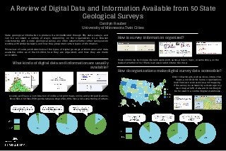
- 1. A Review of Digital Data and Information Available from 50 State Geological Surveys Carolyn Rauber University of Minnesota Twin Cities State geological information is produced and distributed through fifty state surveys, and can be accessed a variety of ways, depending on the organization. As a librarian collaborating with a state geological survey, we often asked whether other surveys were working with similar datasets, and how they presented certain types of information. This review of survey websites looks at the types of digital geological information and data available online as of March 2014, how they are organized, and how they are made accessible. What kinds of digital data and information are usually available? How do organizations make digital survey data accessible? A survey will have a combination of online and print maps, online and print publications, Excel files, CSV files, ESRI geodatabases, shapefiles, KML files, and a smattering of others. How is survey information organized? Most commonly, by its type (data/map/report), series, project, topic, or sometimes, on the basis of whether or not there is an associated interactive map. Direct downloads, web services, interactive maps, and CD/DVD. Some organizations host their own web services and mapping. If the survey is overseen by a state agency (see map at left), data are more likely to be housed in a central digital warehouse.