2. 2318 J. C. Balasch et al.: Reconstruction of the 1874 Santa Tecla’s rainstorm
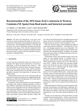
Fig. 1. Map of the area inWestern Catalonia (NE Spain) affected by
Santa Tecla’s rainstorm in 1874 (blue dashed line), with the three
river basins tributaries of the Segre River and the six towns consid-ered
in the reconstruction of the event.
enables to assess the long-term evolution of these rare events
with regard to human impacts on basins and streams; this is
all the more valid in the Mediterranean basin, an area with an
extremely changing climate and under a heavy human pres-sure.
2 Study area
The study area spreads over three catchments in the Segre
River basin, which are, from north to south: Si´o, Ondara and
Corb (Fig. 1). For each catchment, two different outfalls,
corresponding to the places with flood marks available, were
considered resulting in six sub-basins: Mont-roig and Agra-munt
(Si´o); Cervera and T`arrega (Ondara); Guimer`a and Ciu-tadilla
(Corb); actually, the modelling was undertaken sepa-rately
at each one of the six sub-basins.
These three basins total some 600 km2, have a westward
orientation and their headwaters lie on the Catalan Central
Depression’s monoclinal relieves, between 700 and 900m
(Llena, Tallat and Montmaneu ranges); the main land use is
dryland cereal farming, established in Roman times. Table 1
gathers some morphological and hydrographical characteris-tics
of these basins.
The three rivers are left-side tributaries of the downstream
stretch of the Segre River; nevertheless, the Ondara and Corb
rivers flow out into large alluvial fans, before reaching the
Segre. All of them have scarce flows all year round, with a
high-water period around May and long low-water periods,
but, due to irrigation, they never dry up. In any case, autumn
overflowing flash floods are typical, occurring about three or
four times per century (Coma, 1990).
Certainly, severe rainstorms are not rare; this can be par-tially
explained by the regional relief, which triggers storms
in two ways: stopping weather fronts arriving from the
Fig. 2. Flood mark preserved in a column inside Serra’s watermill
remains at Mont-roig by the Si´o River.
Mediterranean Sea and contributing to the development of
convective phenomena during summer and early autumn. All
this results in two rainfall gradients: a northward one and an
altitudinal one.
2.1 The Si´o River basin
The Si´o River basin is the northernmost and the largest of the
three. A flow gauging station at the outlet (Balaguer, EA182)
operated from 1965 to 1992 and recorded an average daily
mean flow of 0.8m3 s−1 and a peak flow of 16m3 s−1.
In this basin, Santa Tecla’s rainstorm caused no casualties;
nevertheless, it destroyed Urgell Canal’s aqueduct at Agra-munt
and devastated every orchard on the floodplain from
Guissona to Balaguer. Two flood marks of this event have
survived: one at Serra’s watermill, 700m NW Mont-roig
(Fig. 2), and one at Agramunt, by the medieval bridge.
2.2 The Ondara River basin
This is the central basin of the three and the one with the
largest percent of farming land use. There have never been
any flow gauging station on the Ondara River; nevertheless,
through water resources modelling, its average flow has been
estimated at 0.5m3 s−1 (CHE, 1996).
Santa Tecla’s effects were the most destructive at T`arrega:
150 dead and 300 damaged buildings; nevertheless (or
maybe because of this), it is the area with more available in-formation
about the event: three marks scattered over the old
town pinpoint the highest water level reached by that flood
(Tuset, 2007; Balasch et al., 2010) (Fig. 3). In addition, there
is an account of the event by a citizen of T`arrega (Salvad´o,
1875), which details the kind of clouds and their location,
the rainstorm starting and ending times, and the peak flow
arrival’s time. Furthermore, recent archaeological surveys
have revealed a three-metre infilling in the riverbed, a cru-cial
piece of information for the reconstruction of the former
fluvial morphology (Fig. 4).
Nat. Hazards Earth Syst. Sci., 10, 2317–2325, 2010 www.nat-hazards-earth-syst-sci.net/10/2317/2010/
3. J. C. Balasch et al.: Reconstruction of the 1874 Santa Tecla’s rainstorm 2319
Table 1. Morphological and hydrographical characteristics of Si´o, Ondara and Corb basins.
Si´o Ondara Corb
Mont-roig Agramunt Cervera T`arrega Guimer`a Ciutadilla
Area (km2) 219 314 86 150 91 123
Main stream length (km) 24 35 17 28.6 15 19.6
Main stream slope (%) 1.4 1.2 1.7 1.4 1.7 2.2
Max/min heigth (m a.s.l.) 745–400 745–335 804–460 804–356 890–500 890–450
Fig. 3. Epigraphic limnimark or flood mark at Sant Agust´ı street
in T`arrega, pointing the maximum water level reached by the Santa
Tecla’s flood.
At Cervera, the flood mark is at Grau’s watermill (Tuset,
2007), which, according to the chronicles, the high waters
kept isolated for one week. The chronicles state as well the
peak flow arrival’s time to that site (Xucl`a, 1977).
2.3 The Corb River basin
The Corb basin is the southernmost and the most forested
of the three, especially in the headwaters. A flow gauging
station operated on the Corb River at its outlet (Vilanova de
la Barca, EA183) from 1965 to 1992; it measured an average
daily mean flow of 0.9m3 s−1 and a peak flow of 48m3 s−1.
There are two Santa Tecla’s flood marks along the Corb,
both in the central stretch of the river, a narrow V-shaped
valley: one at Guimer`a, where the flood killed 35 people and
swept away 96 buildings, and one at Ciutadilla, at Hostal del
Teuler (Mart´ın de Oliva, 2005) (Fig. 5).
Fig. 4. The Ondara River at T`arrega; 1874’s river bed was three
metres below the current thalweg.
3 Methodology
The event reconstruction methodology – put in practice sep-arately
at six modelling points: two in each one of the three
basins – had two stages: the hydraulic modelling and the hy-drological
modelling (Fig. 6). Afterwards, a sensitivity anal-ysis
for each one of the two modelling stages was imple-mented.
The objective of the first stage – the hydraulic reconstruc-tion
– was the estimation of the peak flow through the iter-ative
backwards application of a hydraulic model. The in-put
data were: a digital terrain model; several cross sections,
(Figs. 7 and 8); the cross-sections’ roughness coefficients;
the channel slope; and a tentative peak flow. The process
was iterative, trying different tentative peak flows until the
modelled maximum water level and the actual one – known
through the flood marks – were close enough (i.e. less than
1 cm apart); and it was backwards because the peak flow was
the unknown quantity, instead of being, as usual, an input of
the model. Therefore, some authors call this method “retro-modelling”
(Remo and Pinter, 2007). The model applied was
a unidimensional one in sub-critical permanent conditions
(HEC-RAS v. 4.0; USACE, 2008).
www.nat-hazards-earth-syst-sci.net/10/2317/2010/ Nat. Hazards Earth Syst. Sci., 10, 2317–2325, 2010
4. 2320 J. C. Balasch et al.: Reconstruction of the 1874 Santa Tecla’s rainstorm
Table 2. Input data used in the hydraulic and in the hydrological modelling.
Si´o Ondara Corb
Mont-roig Agramunt Cervera T`arrega Guimer`a Ciutadilla
Flood mark’s height above 5.18 4.88 5.10 8.84 7.72 10.16
1874 river bed (m)
Cross Type Rural Urban Rural Mixed Urban Rural
sections Number 10 108 17 23 50 14
Spacing (m) 20–30 20–30 60–80 40–50 20–30 40–50
Roughness River bed 0.028 0.04 0.035 0.035 0.073 0.073
coefficients River banks 0.085 0.065 – – – –
Rural floodplain 0.04 – 0.03 0.04 – 0.104
Urban floodplain – 0.08 – 0.1 0.099 –
Channel slope (m/m) 0.005 – 0.002 0.0045 0.002 0.009
Rainstorm duration (h) 8 – 8 8 6 6
Antecedent soil moisture III – III III III III
Curve Number (SCS) 85 – 86 85 85 84
Fig. 5. Epigraphic flood mark of Santa Tecla in the Corb River at
the base of a wall of Hostal del Teuler at Ciutadilla.
Thus, the hydraulic modelling required, at each one of the
six studied points:
1. The flood mark data verification – through Bayliss and
Reed’s methodology (2001) – and the topographic mea-surement
of the flood marks
2. The reconstruction of 1874’s river bed and floodplain
morphology, which led to a digital terrain model and,
ultimately, to the cross sections’ selection and to the
measurement of the river bed slope
3. The estimation of roughness coefficients for each seg-ment
of the cross sections (river bed, river banks, and
urban and rural floodplains)
The second stage was the hydrological modelling, the objec-tive
of which was the reconstruction of the event hyetograph.
The process was, once again, iterative and backwards, since
the unknown quantity – rainfall – was an input instead of
an output of the model. Thus, from a tentative hyetograph
constructed from the historical descriptions of the event, the
basin characteristics (soil type, land use and cover) and the
antecedent soil moisture, the runoff or effective rainfall was
calculated using the Soil Conservation Service’s Curve Num-ber
method (SCS, 1985). Then, the Synthetic Unit Hy-drograph
transfer function and a wave propagation method
(Muskingum-Cunge) were successively applied to this runoff
value to obtain a convoluted and routed hydrograph. This
process was repeated with a new tentative hyetograph until
the peak flow of the resulting hydrograph was close enough
to the one found in the first stage, that is, when their relative
difference was less than 1% (Fig. 6). The software applied in
this stage was HEC-HMS v. 3.3 (USACE, 2008), which uses
a lumped rainfall-runoff model.
A lot of data was drawn from historical accounts; for ex-ample,
an historical description of the event (Pley´an de Porta,
1945) states that the soil was at field capacity due to a gener-ous
rain just five days before Santa Tecla’s rainstorm, in 18th
September 1874. This circumstance was crucial in the hydro-logical
modelling, because it led to choose a saturated-soil
Nat. Hazards Earth Syst. Sci., 10, 2317–2325, 2010 www.nat-hazards-earth-syst-sci.net/10/2317/2010/
5. J. C. Balasch et al.: Reconstruction of the 1874 Santa Tecla’s rainstorm 2321
FIRST STAGE: HYDRAULIC MODELLING
Basin characteristics:
- soil type
- land use
- cover
Rainfall duration
New tentative
hyetograph
If difference is too big (>1%)
SECOND STAGE: HYDROLOGICAL MODELLING
New tentative
peak flow
Stream’s
lenght
and slope
Synthetic Unit
Hydrograph
SCS Curve
Number method
(SCS, 1985)
Antecedent
soil
moisture
KNOWN AND INFERED DATA
Tentative
hyetograph
Estimated runoff
Convoluted
hydrograph
Estimated
peak flow
Comparison
If difference is small enough (≤1%)
Accepted hyetograph
Roughness Channel slope
coefficients
Tentative peak flow
Maximum
water level
HEC-RAS (USACE)
KNOWN AND
INFERED DATA
Modelled maximum
water level
Comparison
If difference is too big (>1 cm)
If difference is small enough (≤1 cm)
Accepted peak flow
Digital terrain
model (cross
sections)
Muskingum-Cunge
routing method
Fig. 6. Methodological procedure for the calculation of the event’s
peak flow and hyetograph.
Fig. 7. Present-day (brown line) and 1874 (red line) cross-sections
of the Ondara River at Sant Agust´ı Bridge (and the eponymous
street), with the indication of the maximum water level (blue line)
reached by the Santa Tecla flood.
Fig. 8. Aerial photograph of the Ondara river channel (blue line) at
T`arrega with the location of the Sant Agust´ı Bridge, cross section
(brown line) and the rest of cross sections (green lines) used in the
hydraulic modelling. This figure shows as well the alleged location
of the external walls of the city and the disappeared Sant Agust´ı
monastery and nearby buildings according to the archaeological re-mains.
condition (condition III) in the Curve Number method. Like-wise,
other historical sources furnished the starting and end-ing
times of the rainstorm: around 22:00 and 06:00, respec-tively
(Iglesies, 1971; Salvad´o, 1875).
Table 2 gathers the input data used the hydraulic and the
hydrological modelling, respectively.
Once the hydraulic and the hydrological modelling were
done, their robustness was assessed through sensitivity anal-yses.
More precisely, in the hydraulic model analysis, the effect
of a variation in the maximum water level on the peak flow
was quantified. In order to do this, at each studied cross-section,
the hydraulic model was applied several times, the
input data being variations of the peak flow actually found
(Qp) and the output being the peak water levels due to each
one of these peak flow variations, which were Qp ±1%,
Qp ±2%, Qp ±5%, Qp ±10%, Qp ±20%, Qp ±50% and
Qp +100%. Afterwards, for each of the six cross-sections
separately, a linear relation between both quantities (peak
flow variation (1Qp) and peak water stage variation (1d))
was found, the slope factor of which (a in 1Qp=a·1d+b)
quantified the variation of peak flow due to a one-unit varia-tion
of the peak water stage.
On the other hand, the hydrological model analysis as-sessed
the influence of both the Curve Number and the an-tecedent
soil moisture condition on the peak flow.
This was done by applying several times the hydrological
model in two subbasins, representative of the six, with the
following changes:
www.nat-hazards-earth-syst-sci.net/10/2317/2010/ Nat. Hazards Earth Syst. Sci., 10, 2317–2325, 2010
6. 2322 J. C. Balasch et al.: Reconstruction of the 1874 Santa Tecla’s rainstorm
Table 3. Results of the hydraulic and the hydrological modelling.
Si´o Ondara Corb
Mont-roig Agramunt Cervera T`arrega Guimer`a Ciutadilla
Peak-flow (m3 s−1) 1120 1010 852 1190 410 580
Specific peak flow (m3 s−1 km−2) 5.1 3.2 9.9 7.9 4.5 4.7
Area-weighed rainfall over the basin (mm) 112 – 155 147 114 114
Maximum rain intensity (mm h−1) 56 – 70 67 61 61
Surface runoff volume (hm3) 15.1 – 10.0 15.9 5.9 14.0
Runoff coefficient (%) 61 – 77 72 57 59
Lag-time (h) 4 – 2.5 3.5 3 3.5
Table 4. Results of the sensitivity analyses on the hydraulic and the hydrological modelling.
Sensitivity analysis on Sensitivity analyses on the hydrological modelling
the hydraulic modelling
Basin Cross- Peak flow variation (%) due to Peak flow variation (%) due to Peak flow variation (%) due to
section an increase of 1 cm in the an increase of one unit in the a change in the antecedent
maximum water level Curve Number soil moisture condition from III to II
Si´o
Mont-roig 0.9 3.3 – 41
Agramunt – – –
Ondara
Cervera 0.9 – –
T`arrega 0.3 2.2 – 32
Corb
Guimer`a 0.5 – –
Ciutadilla 1.4 – –
1. Modifications in the Curve Number value around the
calculated one (CN): CN±2 units and CN±4 units.
2. Change of the antecedent soil moisture condition from
III to II (which implied, actually, to modify the Curve
Number value).
Then, linear functions were fitted to the data pairs (Curve
Number, Peak flow variation), the slope factor of these linear
functions (a in 1Qp=a·1CN+b) quantifying the amount of
peak flow variation per unity of Curve Number variation.
4 Results and discussion
As Table 3 and Fig. 9 show, the greatest peak flow occurred
in Ondara at T`arrega (1190m3 s−1) and the greatest specific
peak flow, in Ondara at Cervera (9.9m3 s−1km−2).
Besides, it is worth noting three area-dependent effects:
1. In the Si´o, the peak flow decreased downstream – this
may be explained by the spatial distribution of the rain,
concentrated on the headwaters, and by the size of the
basin.
2. In the Ondara, the specific peak flow increased dramat-ically
upstream (i.e. as basin size decreased). Indeed,
the specific peak flow of the Ondara at Cervera roughly
doubled those of the neighbouring Si´o and Corb.
3. In the Corb, the specific peak flow slightly increased
downstream (i.e. as basin size increased) while it de-creased
in Si´o and Ondara.
Since the hydrological behaviour was almost the same in
the three basins (Curve Number of 85 and antecedent soil
moisture condition III), the differences in specific peak flow
(both, the differences in its magnitude and in its downstream
evolution) between the Si´o, the Ondara and the Corb may
be explained by, on one hand, spatial differences in rainfall
depths and intensities and, on the other hand, differences in
streams’ lengths and slopes and in the subbasins spatial ar-rangement,
features that determine the rainfall-runoff trans-fer
function (SCS’s Unit Hydrograph) and the flow transit
function (Munskingum-Cunge).
Actually, the specific peak flow value at Cervera was ex-traordinary:
indeed, it exceeded – and the rest were similar
to – the greatest specific peak flow in the systematic gaug-ing
data series in the Ebro basin: 5.4m3 s−1 km−2 in Seco
River at Oliete, in 1945, the second highest gauging record
staying far behind: 3.3m3 s−1 km−2 in Algars River at Horta
de Sant Joan, in 1967 (L´opez-Bustos, 1981). Cervera’s value
Nat. Hazards Earth Syst. Sci., 10, 2317–2325, 2010 www.nat-hazards-earth-syst-sci.net/10/2317/2010/
7. J. C. Balasch et al.: Reconstruction of the 1874 Santa Tecla’s rainstorm 2323
P (mm)
0
20
40
60
1200
1000
800
600
400
200
0
21:00 23:00 01:00 03:00 05:00 07:00 09:00 11:00 13:00 15:00
t (h)
Q (m3 s-1)
Q Mont-roig
(a)
P (mm)
0
20
40
60
1200
1000
800
600
400
200
0
21:00 23:00 01:00 03:00 05:00 07:00 09:00 11:00 13:00 15:00
t (h)
Q (m3 s-1)
Q Cervera Q Tàrrega
(b)
0
20
1200
1000
800
600
400
200
0
21:00 23:00 01:00 03:00 05:00 07:00 09:00 11:00 13:00 15:00
t (h)
Q (m3 s-1)
Q Guimerà Q Ciutadilla
P (mm)
40
60
(c)
Fig. 9. Reconstructed hyetographs and hydrographs of Si´o at Mont-roig
(a), Ondara at T`arrega and Cervera (b), and Corb at Guimer`a
and Ciutadilla (c).
even exceeded the specific peak flow of the non-systematic
regional data series: 6m3 s−1 km−2 (Thorndycraft et al.,
2006). Nevertheless, the torrentiality indexes of the floods
(i.e. the quotient of the peak flow divided by the annual mean
flow) were around 104 in the three basins, and can be judged
as typical in Mediterranean rivers (Conacher and Sala, 1998).
Besides, lag-times were small (2.5 h in Ondara at Cervera,
3 h in Corb at Guimer`a, 4 h in Si´o at Mont-roig); this agrees
with the fast response of small catchments in a saturated-soil
condition and, along with the peak flows’ magnitudes,
explains the catastrophic effects of the event.
In any case, regarding the damages, Santa Tecla’s floods
can be classified as catastrophic; nevertheless, this event is
not recorded in the principal Mediterranean data bases, or,
if recorded, it is not classified as catastrophic (Barriendos et
al., 2003; Barnolas and Llasat, 2007). The probable reason
for this is that the affected zone is far from cities along larger
rivers with extensive, long historical archives. More recently,
using a different approach, Barriendos and Rodrigo (2006)
classified Santa Tecla’s floods as a Large Catastrophic Event
(LCE) because it affected several basins.
On the other hand, the rainstorms required to generate
such peak flows under a saturated-soil moisture condition are
similar in Si´o and Corb and higher in Ondara, according to
the hydrological modelling results: the raindepths being 112,
114 and 147 mm, respectively and the maximum rain inten-sities
being 56, 61 and 67mmh−1 (Table 3); this, in spite of
the same Curve Number, resulted in different runoff coeffi-cients:
59% in Corb at Ciutadilla, 61% in Si´o at Mont-roig
and 77% in Ondara at Cervera.
If compared to a frequency analysis of 24-h maximum
rainfall data series in Catalonia (Casas, 2005), the Santa
Tecla’s rainstorm, even though it had a duration of only eight
hours, have had a return period of 500 years in Ondara’s
headwaters, and greater than 250 years in Si´o’s and Corb’s
headwaters.
In fact, Barriendos and Mart´ın-Vide (1988) and Llasat et
al. (2005) conclude that extreme floods frequency increased
at both the beginning and the end of Little Ice Age (16th–
19th centuries); and indeed, Santa Tecla happened at the end
of LIA.
The sensitivity analysis on the hydraulic modelling (Ta-ble
4) pointed out that the reconstruction of peak flows
from flood marks is a sound approach, since, at least in our
case, the uncertainty in the peak flow estimation was only
around 1% per each centimetre of maximum water level er-ror,
which, in real field conditions, could arise up to 3–4 cm.
Besides, the sensitivity analyses on the hydrological mod-elling
brought out the huge influence of two steps of the pro-cedure:
the Curve Number and the antecedent soil moisture
assignation. Indeed, an error of only one unit in the Curve
Number, the determination of which is somewhat arbitrary
and, thus, prone to a higher error, produced a variation in
the peak flow of around 2–3%. Similarly, the change from
antecedent soil moisture condition III to II reduced the peak
flow by 30–40%.
However, there are many other sources of error not yet
analyzed. For instance, the suspended-load concentrations,
which were very high – about 12% in volume –, as could
be estimated from some samples exceptionally preserved in
unaltered cellars at T`arrega. This fact points out that some
characteristics of the flow’s mechanics, modified by the sus-pended
sediment and which could have had a crucial impact
on hydraulic modelling, were not taken into account in this
study.
www.nat-hazards-earth-syst-sci.net/10/2317/2010/ Nat. Hazards Earth Syst. Sci., 10, 2317–2325, 2010
8. 2324 J. C. Balasch et al.: Reconstruction of the 1874 Santa Tecla’s rainstorm
5 Conclusions
The hydraulic and hydrological reconstruction of Santa
Tecla’s rainstorm focused on the inland basins flowing into
the Segre River, which are located in the northwestern quad-rant
of the probable affected area and cover about a 20% of
it.
The results suggest that the rainfall was spatially hetero-geneous,
having a maximum in the central of the three stud-ied
basins (Ondara); besides, although the rainfall depths at
the origin of this severe hydrological event don’t seem to be
particularly high or intense in a Mediterranean context, they
actually are if compared to systematic rainfall data series of
inland Catalonia.
Likewise, the calculated specific peak flows were greater
than those recorded and modelled in similar-sized catch-ments
in the Ebro basin. Certainly, the floods caused
high-impact damages on the riverside towns. Moreover,
the high soil moisture content before the event favoured
the runoff production, multiplying the magnitude of Santa
Tecla’s floods.
However, antecedent soil moisture is not taken into ac-count
in the magnitude-frequency assessment of extraordi-nary
floods, in which often only the 24-h rainfall is consid-ered;
this variable is all the more relevant since the sensitivity
analysis revealed that an error in the antecedent soil moisture
condition choice, a difficult one in lack of proper documen-tary
information, can have, along with a wrong Curve Num-ber
determination, dramatic consequences in the peak flow
estimation.
Therefore, a thorough exploration of local documentary
sources is essential in flood reconstructions in order to find
details which may be crucial in improving the modelling re-sults
and uncertainties.
And, although only the north-western part of the affected
area could be studied so far, flood marks and documentary
information of the event are available in other basins (Font
Vella de Conesa, Francol´ı, Llobreg´os, Set). This fact makes
possible a more extensive study of Santa Tecla’s rainstorm,
which would help to improve current understanding of it.
Actually, the ultimate objective of this research would be
the improvement of the probability analysis of extreme hy-drological
events through the enlargement of the systematic
rainfall data series with data from flood reconstruction.
Acknowledgements. The authors thank M.C. Llasat, G. Benito and
another anonymous reviewer for their helpful comments which
improved the text. They want to thank, as well, the Catalan Water
Authority (ACA).
Edited by: M. C. Llasat
Reviewed by: G. Benito and another anonymous referee
References
Balasch, J. C., Tuset, J., and Ruiz-Bellet, J. L.: Reconstructing the
1874 Santa Tecla flash flood in the Ondara River (Ebro Basin,
NE Spain), Adv. Geosci., 26, 45–48, 2010,
http://www.adv-geosci.net/26/45/2010/.
Barnolas, M. and Llasat, M. C.: Metodolog´ıa para el estudio de
inundaciones hist´oricas en Espa˜na e implementaci´on de un SIG
en las cuencas del Ter, Segre y Llobregat. CEH-CEDEX, Mono-graf
´ıas M-90, Ministerio de Fomento, Madrid, 264 pp., 2007.
Barriendos, M. and Mart´ın-Vide, J.: Secular climatic oscillations
as indicated by catastrophic floods in the Spanish Mediterranean
coastal area (14th-19th centuries), Climatic Change, 38, 473–
491, 1988.
Barriendos, M., Coeur, D., Lang, M., Llasat, M. C., Naulet, R.,
Lemaitre, F., and Barrera, A.: Stationarity analysis of histori-cal
flood series in France and Spain (14th–20th centuries), Nat.
Hazards Earth Syst. Sci., 3, 583–592, doi:10.5194/nhess-3-583-
2003, 2003.
Barriendos, M. and Rodrigo, F. S.: Study of historical flood events
on Spanish rivers using documentary data, Hydrol. Sci. J., 51(5),
765–783, 2006.
Bayliss, A. C. and Reed, D. W.: The use of historical data in flood
frequency estimation. CEH-NERC, Wallingford, UK, 87 pp.,
2001.
Casas, M. C.: An´alisis espacial y temporal de las lluvias extremas
en Catalunya. Modelizaci´on y clasificaci´on objetiva. PhD Thesis,
University of Barcelona, 199 pp., 2005.
Confederaci´on Hidrogr´afica del Ebro (CHE): Propuesta de Plan
Hidrol´ogico de la Cuenca del Ebro. Anexo 2: Aportaciones de
las estaciones de aforo. Ministerio de Medio Ambiente, Medio
Rural y Marino, Madrid, 10 pp., 1996.
Coma, M. T.: Les inundacions en el terme municipal de T`arrega.
Urtx, 2, 249–259, 1990.,
Conacher, A. and Sala, M.: Land degradation in Mediterranean en-vironment
of the World: nature and extent, causes and solutions,
Wiley, Chichester, New York, 491 pp., 1998.
Iglesies, J.: L’aiguat de santa Tecla (23 de setembre de 1874),
Episodis de la Hist`oria, 156, R. Dalmau, Barcelona, 62 pp., 1971.
Llasat, M. C., Barriendos, M., Barrera, T., and Rigo, T.: Floods in
Catalonia (NE Spain) since the 14th Century. Climatological and
meteorological aspects from historical documentary sources and
old instrumental records, J. Hydrol., 313, 32–47, 2005.
L´opez-Bustos, A.: Tomando el pulso a las grandes crecidas de los
r´ıos peninsulares, Revista de Obras P´ublicas, 3190, 179–192,
1981.
Martin de Oliva, J.: Estudio de inundabilidad de la cuenca alta del
r´ıo Corb. Reconstrucci´on del episodio de Santa Tecla (1874), Un-published
Master Thesis, ETSEA, University of Lleida, 228 pp.,
2005.
Pley´an de Porta, J: Efem´erides leridanas recogidas y ordenadas, In-stitut
d’Estudis Ilerdencs, Lleida, Espa˜na, 1945.
Remo, J. W. F. and Pinter, N.: Retro-modeling the Middle Missis-sipi
River, J. Hydrol., 337, 421–435, 2007.
Salvad´o, J.: Memoria de la inundaci´on acaecida en la villa de
T´arrega en la madrugada del d´ıa 23 de Setiembre del a˜no 1874.
Est. Tip. Ramirez, Barcelona, Espa˜na, 86 pp., 1875.
Soil Conservation Service: Estimation of direct runoff from storm
rainfall, Chapter 10, in Hydrology Natl. Eng. Handbook, Suppl.
A, Section 4. USDA-SCS, Washington DC, 1985.
Nat. Hazards Earth Syst. Sci., 10, 2317–2325, 2010 www.nat-hazards-earth-syst-sci.net/10/2317/2010/
9. J. C. Balasch et al.: Reconstruction of the 1874 Santa Tecla’s rainstorm 2325
Thorndycraft, V., Barriendos, M., Benito, G., Rico, M., and Casas,
A.: The catastrophic floods of AD 1617 in Catalonia (northeast
Spain) and their climatic context, Hydrol. Sci. J., 51(5), 899–912,
2006.
Tuset, J.: Reconstrucci´o de l’aiguat de Santa Tecla en el riu On-dara
a T`arrega a partir de limnimarques i restes de dip`osits
decantats. Unpublished Master Thesis, ETSEA, University of
Lleida, 224 pp., 2007.
US Army Corps of Engineers (USACE): HEC-RAS River Analysis
System: Hydraulic Reference Manual, US Army Corps of Engi-neers
Hydrologic Engineering Center, Davis, CA, 2008.
Xucl`a, R. M.: Sopar al mol´ı d’en Grau, Segarra, 773, 1–3, 1977.
www.nat-hazards-earth-syst-sci.net/10/2317/2010/ Nat. Hazards Earth Syst. Sci., 10, 2317–2325, 2010