This document provides instructions for a classroom activity where students will label ocean basin features on three profiles and maps. Students are asked to match maps with profiles, draw a line indicating sea level, and label landforms and ocean zones. They also answer questions about crust types and relative depths. The activity aims to teach students about the structure of ocean basins through hands-on labeling and mapping.
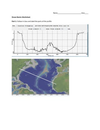
5. Part 2: The 3 maps below refer to the profiles on the following pages. First you must determine which
map matches which profile. Label both the map
and the profiles with the following labels. First
start by drawing a line at sea level.
South America- label the Pacific Ocean, Atlantic
Ocean, Andes mountains, continental shelf,
continental slope, abyssal plain
Alaska- label continental shelf, island (volcanic), ocean
trench, Pacific Ocean, abyssal plain
This profile includes the Bering Sea. Do you think that
the profiled section of the Bering Sea is made of
Continental Crust or Oceanic Crust?
________________________
Asia and Japan- label Asia, Japan, ocean trench, Sea of Japan,
Pacific Ocean. Which sea/ocean is deeper?_______________