SlideShare ist ein Scribd-Unternehmen logo
1 von 8
Downloaden Sie, um offline zu lesen
Base your answers to questions 1 and 2 on the topographic map below. Points X, Y, and Z are locations on the map. Elevations are expressed in
meters.


1. Mill River generally flows toward the

      1) southeast

      2) southwest

      3) northeast

      4) northwest


2. What is the elevation of point Z?

      1) 190 m

      2) 220 m

      3) 240 m

      4) 250 m
Base your answers to questions 3 and 4 on the maps below. Points A, B, C, X, and Y are locations on the topographic map. The small map
identifies the New York State region shown in the topographic map.


3. What is the elevation of point A on the topographic map?

      1) 1,700 ft

      2) 1,650 ft

      3) 1,600 ft

      4) 1,550 ft
4. What is the approximate gradient between point X and point Y?

      1) 100 ft/mi

      2) 250 ft/mi

      3) 500 ft/mi

      4) 1,000 ft/mi


   5. A stream has a source at an elevation of 1,000. meters. It    7. What is the elevation of the highest contour line shown on
      ends in a lake that has an elevation of 300. meters. If the      the map below?
      lake is 200. kilometers away from the source, what is the
      average gradient of the stream?

      1)   1.5 m/km

      2)   3.5 m/km

      3)   10. m/km

      4)   15 m/km


   6. The diagram below is a contour map. Between which two
      points is the slope of the hill steepest?


                                                                       1)   10,000 feet

                                                                       2)   10,688 feet

                                                                       3)   10,700 feet

                                                                       4)   10,788 feet


      1)   A and B

      2)   B and C

      3)   C and D

      4)   A and D
8. The map below represents an elevation field.


   What is the approximate gradient between point A and
   point B?

   1)   0.5 m/km

   2)   2.0 m/km

   3)   3.0 m/km

   4)   4.0 m/km
Base your answers to questions 9 through 11 on the contour map below. Points A, B, C, D, X, and Y are locations on the map. Elevations are
expressed in feet. The maximum elevation of Basket Dome is indicated at point X.


9. In which general direction does Tenaya Stream flow?

      1) southeast to northwest

      2) northwest to southeast

      3) southwest to norheast

      4) northeast to southwest
10. The highest elevation on the map is at point

      1) X

      2) Y

      3) C

      4) D


11. The highest elevation of Basket Dome 40 years ago was measured at 7,600 feet. What is the rate of change in elevation for this area?

      1) 0.6 in/yr

      2) 1.7 in/yr

      3) 24 in/yr

      4) 40 in/yr


Base your answers to questions 12 through 15 on the contour map of an island below. Points A through G represent locations on the island.
Elevations are in meters.


12. Which point is located on the steepest slope?

      1) F

      2) B

      3) C

      4) D
13. In which direction does the Cinder River flow?

      1) southeast

      2) southwest

      3) northeast

      4) northwest


14. What is the contour interval for this map?

      1) 10 m

      2) 15 m

      3) 20 m

      4) 25 m


15. Which two points have the same elevation?

      1) G and F

      2) B and D

      3) C and D

      4) G and C
Answer Key
              HW 106 Earth Science Mapping Questions [Oct 06, 2009]


1.    3

2.    2

3.    1

4.    4

5.    2

6.    2

7.    3

8.    2

9.    4

10.       3

11.       1

12.       3

13.       4

14.       3

15.       3

Weitere ähnliche Inhalte

Was ist angesagt?

Contouring - Surveying...for civil Engineering and Architecture..
Contouring - Surveying...for civil Engineering and Architecture..Contouring - Surveying...for civil Engineering and Architecture..
Contouring - Surveying...for civil Engineering and Architecture..Pramesh Hada
 
Fundamentals of surveying
Fundamentals of surveyingFundamentals of surveying
Fundamentals of surveyingSimonReuben2
 
Topographic Map Presentation
Topographic Map PresentationTopographic Map Presentation
Topographic Map Presentationdwinter1
 
Topic 3 mass haul diagram
Topic 3   mass haul diagramTopic 3   mass haul diagram
Topic 3 mass haul diagramkmasz kamal
 
Chapter 3 gateway 123 combined
Chapter 3 gateway 123 combinedChapter 3 gateway 123 combined
Chapter 3 gateway 123 combinedMissST
 
Surveying ii module iii class 1,2
Surveying ii module iii class 1,2Surveying ii module iii class 1,2
Surveying ii module iii class 1,2SHAMJITH KM
 
Profiles (longitudinal section) & cross sections
Profiles (longitudinal section) & cross sectionsProfiles (longitudinal section) & cross sections
Profiles (longitudinal section) & cross sectionsBahzad5
 
introduction of surveying
introduction of surveyingintroduction of surveying
introduction of surveyingSelf-employed
 
Using GIS for Civil/Environmental Projects
Using GIS for Civil/Environmental ProjectsUsing GIS for Civil/Environmental Projects
Using GIS for Civil/Environmental ProjectsMehmet Secilmis
 
Earth Science Mapping; interactive topographic maps
Earth Science Mapping; interactive topographic mapsEarth Science Mapping; interactive topographic maps
Earth Science Mapping; interactive topographic mapsTim Corner
 
Urban transportation planning
Urban transportation planningUrban transportation planning
Urban transportation planningPiter Biswas
 
Central place theory
Central place theoryCentral place theory
Central place theoryCSMains
 
Cartography lec #4
Cartography lec #4Cartography lec #4
Cartography lec #4Nazir Ahmed
 
Topographic Map
Topographic MapTopographic Map
Topographic Mapmjcnavarro
 
Transportation modeling and planning ( The Four-Step Model )
Transportation modeling and planning ( The Four-Step Model )Transportation modeling and planning ( The Four-Step Model )
Transportation modeling and planning ( The Four-Step Model )Ahmad Ali Miftah
 
GEOGRAPHY IGCSE: GEOGRAPHICAL SKILLS - CONTOURS AND SPOT HEIGHTS
GEOGRAPHY IGCSE: GEOGRAPHICAL SKILLS - CONTOURS AND SPOT HEIGHTSGEOGRAPHY IGCSE: GEOGRAPHICAL SKILLS - CONTOURS AND SPOT HEIGHTS
GEOGRAPHY IGCSE: GEOGRAPHICAL SKILLS - CONTOURS AND SPOT HEIGHTSGeorge Dumitrache
 

Was ist angesagt? (20)

Contouring - Surveying...for civil Engineering and Architecture..
Contouring - Surveying...for civil Engineering and Architecture..Contouring - Surveying...for civil Engineering and Architecture..
Contouring - Surveying...for civil Engineering and Architecture..
 
Control surveying
Control surveyingControl surveying
Control surveying
 
Fundamentals of surveying
Fundamentals of surveyingFundamentals of surveying
Fundamentals of surveying
 
Topographic Map Presentation
Topographic Map PresentationTopographic Map Presentation
Topographic Map Presentation
 
Topic 3 mass haul diagram
Topic 3   mass haul diagramTopic 3   mass haul diagram
Topic 3 mass haul diagram
 
Chapter 3 gateway 123 combined
Chapter 3 gateway 123 combinedChapter 3 gateway 123 combined
Chapter 3 gateway 123 combined
 
Surveying ii module iii class 1,2
Surveying ii module iii class 1,2Surveying ii module iii class 1,2
Surveying ii module iii class 1,2
 
Profiles (longitudinal section) & cross sections
Profiles (longitudinal section) & cross sectionsProfiles (longitudinal section) & cross sections
Profiles (longitudinal section) & cross sections
 
introduction of surveying
introduction of surveyingintroduction of surveying
introduction of surveying
 
Using GIS for Civil/Environmental Projects
Using GIS for Civil/Environmental ProjectsUsing GIS for Civil/Environmental Projects
Using GIS for Civil/Environmental Projects
 
Earth Science Mapping; interactive topographic maps
Earth Science Mapping; interactive topographic mapsEarth Science Mapping; interactive topographic maps
Earth Science Mapping; interactive topographic maps
 
Urban transportation planning
Urban transportation planningUrban transportation planning
Urban transportation planning
 
Vertical alignment
Vertical alignmentVertical alignment
Vertical alignment
 
Central place theory
Central place theoryCentral place theory
Central place theory
 
Cartography lec #4
Cartography lec #4Cartography lec #4
Cartography lec #4
 
Traversing
TraversingTraversing
Traversing
 
Topographic Map
Topographic MapTopographic Map
Topographic Map
 
Transportation modeling and planning ( The Four-Step Model )
Transportation modeling and planning ( The Four-Step Model )Transportation modeling and planning ( The Four-Step Model )
Transportation modeling and planning ( The Four-Step Model )
 
GEOGRAPHY IGCSE: GEOGRAPHICAL SKILLS - CONTOURS AND SPOT HEIGHTS
GEOGRAPHY IGCSE: GEOGRAPHICAL SKILLS - CONTOURS AND SPOT HEIGHTSGEOGRAPHY IGCSE: GEOGRAPHICAL SKILLS - CONTOURS AND SPOT HEIGHTS
GEOGRAPHY IGCSE: GEOGRAPHICAL SKILLS - CONTOURS AND SPOT HEIGHTS
 
GPS Surveying
GPS SurveyingGPS Surveying
GPS Surveying
 

Andere mochten auch

Andere mochten auch (8)

Isolines and contour lines
Isolines and contour linesIsolines and contour lines
Isolines and contour lines
 
Section 1 structure
Section 1 structureSection 1 structure
Section 1 structure
 
Contours And Its Uses
Contours And Its UsesContours And Its Uses
Contours And Its Uses
 
Topomaps
TopomapsTopomaps
Topomaps
 
surveying contouring
surveying contouring surveying contouring
surveying contouring
 
Reading a topographic map
Reading a topographic mapReading a topographic map
Reading a topographic map
 
height on maps contours
 height on maps contours height on maps contours
height on maps contours
 
Contouring
ContouringContouring
Contouring
 

Ähnlich wie Contour map hw problems

Applied geophysics - 3D survey of the Lesser Antilles subduction zone present...
Applied geophysics - 3D survey of the Lesser Antilles subduction zone present...Applied geophysics - 3D survey of the Lesser Antilles subduction zone present...
Applied geophysics - 3D survey of the Lesser Antilles subduction zone present...Riccardo Pagotto
 
Review 6 _earthquakes___crustal_activity_sc
Review 6 _earthquakes___crustal_activity_scReview 6 _earthquakes___crustal_activity_sc
Review 6 _earthquakes___crustal_activity_scLexume1
 
CSEC GEOGRAPHY PAPER 1- JUNE 2015
CSEC GEOGRAPHY PAPER 1-  JUNE 2015CSEC GEOGRAPHY PAPER 1-  JUNE 2015
CSEC GEOGRAPHY PAPER 1- JUNE 2015Oral Johnson
 
Weathering And Erosion Exam
Weathering And Erosion ExamWeathering And Erosion Exam
Weathering And Erosion Examguest4823242
 
Simple explanations to CSEC Geography 2013 multiple choice
Simple explanations to CSEC Geography 2013 multiple choiceSimple explanations to CSEC Geography 2013 multiple choice
Simple explanations to CSEC Geography 2013 multiple choiceOral Johnson
 
College Physics 9th Edition Serway Test Bank
College Physics 9th Edition Serway Test BankCollege Physics 9th Edition Serway Test Bank
College Physics 9th Edition Serway Test BankJimenezee
 
UMC Final -1st Term 2012----Solution
UMC   Final -1st Term 2012----SolutionUMC   Final -1st Term 2012----Solution
UMC Final -1st Term 2012----SolutionEhab AL-Timimi
 
2019-10-15 Small-scale deformation of active volcanoes measured by
2019-10-15 Small-scale deformation of active volcanoes measured by 2019-10-15 Small-scale deformation of active volcanoes measured by
2019-10-15 Small-scale deformation of active volcanoes measured by Yosuke Aoki
 
Review 7 weathering__erosion__deposition_sc
Review 7 weathering__erosion__deposition_scReview 7 weathering__erosion__deposition_sc
Review 7 weathering__erosion__deposition_scLexume1
 
IIT - JEE Main 2016 Sample Paper 3
IIT - JEE Main 2016 Sample Paper 3IIT - JEE Main 2016 Sample Paper 3
IIT - JEE Main 2016 Sample Paper 3APEX INSTITUTE
 
AP PGECET Geo Engineering 2016 question paper
AP PGECET Geo Engineering 2016 question paperAP PGECET Geo Engineering 2016 question paper
AP PGECET Geo Engineering 2016 question paperEneutron
 
CSEC GEOGRAPHY PAPER 1- 2017
CSEC GEOGRAPHY PAPER 1- 2017CSEC GEOGRAPHY PAPER 1- 2017
CSEC GEOGRAPHY PAPER 1- 2017Oral Johnson
 
STUDENT’S NAME _________________________Multiple Choice – Hi.docx
STUDENT’S   NAME  _________________________Multiple Choice – Hi.docxSTUDENT’S   NAME  _________________________Multiple Choice – Hi.docx
STUDENT’S NAME _________________________Multiple Choice – Hi.docxhanneloremccaffery
 

Ähnlich wie Contour map hw problems (20)

Geography fm 4
Geography fm 4Geography fm 4
Geography fm 4
 
Applied geophysics - 3D survey of the Lesser Antilles subduction zone present...
Applied geophysics - 3D survey of the Lesser Antilles subduction zone present...Applied geophysics - 3D survey of the Lesser Antilles subduction zone present...
Applied geophysics - 3D survey of the Lesser Antilles subduction zone present...
 
Review 6 _earthquakes___crustal_activity_sc
Review 6 _earthquakes___crustal_activity_scReview 6 _earthquakes___crustal_activity_sc
Review 6 _earthquakes___crustal_activity_sc
 
CSEC GEOGRAPHY PAPER 1- JUNE 2015
CSEC GEOGRAPHY PAPER 1-  JUNE 2015CSEC GEOGRAPHY PAPER 1-  JUNE 2015
CSEC GEOGRAPHY PAPER 1- JUNE 2015
 
Review student's copy
Review student's copyReview student's copy
Review student's copy
 
Weathering And Erosion Exam
Weathering And Erosion ExamWeathering And Erosion Exam
Weathering And Erosion Exam
 
Rate of change student's copy
Rate of change student's copyRate of change student's copy
Rate of change student's copy
 
Simple explanations to CSEC Geography 2013 multiple choice
Simple explanations to CSEC Geography 2013 multiple choiceSimple explanations to CSEC Geography 2013 multiple choice
Simple explanations to CSEC Geography 2013 multiple choice
 
College Physics 9th Edition Serway Test Bank
College Physics 9th Edition Serway Test BankCollege Physics 9th Edition Serway Test Bank
College Physics 9th Edition Serway Test Bank
 
Glacial Group Paper
Glacial Group PaperGlacial Group Paper
Glacial Group Paper
 
UMC Final -1st Term 2012----Solution
UMC   Final -1st Term 2012----SolutionUMC   Final -1st Term 2012----Solution
UMC Final -1st Term 2012----Solution
 
2019-10-15 Small-scale deformation of active volcanoes measured by
2019-10-15 Small-scale deformation of active volcanoes measured by 2019-10-15 Small-scale deformation of active volcanoes measured by
2019-10-15 Small-scale deformation of active volcanoes measured by
 
Deposition Take Home Quiz
Deposition Take Home QuizDeposition Take Home Quiz
Deposition Take Home Quiz
 
Review 7 weathering__erosion__deposition_sc
Review 7 weathering__erosion__deposition_scReview 7 weathering__erosion__deposition_sc
Review 7 weathering__erosion__deposition_sc
 
IIT - JEE Main 2016 Sample Paper 3
IIT - JEE Main 2016 Sample Paper 3IIT - JEE Main 2016 Sample Paper 3
IIT - JEE Main 2016 Sample Paper 3
 
AP PGECET Geo Engineering 2016 question paper
AP PGECET Geo Engineering 2016 question paperAP PGECET Geo Engineering 2016 question paper
AP PGECET Geo Engineering 2016 question paper
 
CSEC GEOGRAPHY PAPER 1- 2017
CSEC GEOGRAPHY PAPER 1- 2017CSEC GEOGRAPHY PAPER 1- 2017
CSEC GEOGRAPHY PAPER 1- 2017
 
STUDENT’S NAME _________________________Multiple Choice – Hi.docx
STUDENT’S   NAME  _________________________Multiple Choice – Hi.docxSTUDENT’S   NAME  _________________________Multiple Choice – Hi.docx
STUDENT’S NAME _________________________Multiple Choice – Hi.docx
 
Are you a Spatial thinker
Are you a Spatial thinkerAre you a Spatial thinker
Are you a Spatial thinker
 
Map reading
Map readingMap reading
Map reading
 

Mehr von West Hollow MS Ms. Gill (20)

Welcome to Regents Earth Science
Welcome to Regents Earth ScienceWelcome to Regents Earth Science
Welcome to Regents Earth Science
 
Syllabus earth science
Syllabus earth scienceSyllabus earth science
Syllabus earth science
 
Prologue pp1 2012
Prologue pp1 2012Prologue pp1 2012
Prologue pp1 2012
 
Prologue np1 2012
Prologue np1 2012Prologue np1 2012
Prologue np1 2012
 
Geologic History Note Packet
Geologic History Note PacketGeologic History Note Packet
Geologic History Note Packet
 
Geologic History Powerpoint Notes
Geologic History Powerpoint NotesGeologic History Powerpoint Notes
Geologic History Powerpoint Notes
 
Earthquakes final
Earthquakes finalEarthquakes final
Earthquakes final
 
Dynamic earth np1
Dynamic earth np1Dynamic earth np1
Dynamic earth np1
 
Earthquakes final
Earthquakes finalEarthquakes final
Earthquakes final
 
Plates ex2
Plates ex2Plates ex2
Plates ex2
 
Plates Lab
Plates LabPlates Lab
Plates Lab
 
Oceans and Basin Do Now
Oceans and Basin Do NowOceans and Basin Do Now
Oceans and Basin Do Now
 
Pangaea lab
Pangaea labPangaea lab
Pangaea lab
 
Ocean bottom profiles
Ocean bottom profilesOcean bottom profiles
Ocean bottom profiles
 
Global Tectonic Plates HW
Global Tectonic Plates HWGlobal Tectonic Plates HW
Global Tectonic Plates HW
 
Earths Interior Questions HW
Earths Interior Questions HWEarths Interior Questions HW
Earths Interior Questions HW
 
Dynamic Earth Note Packet
Dynamic Earth Note PacketDynamic Earth Note Packet
Dynamic Earth Note Packet
 
Dynamic Earth
Dynamic EarthDynamic Earth
Dynamic Earth
 
Earths dimension sci 8 ppt np1
Earths dimension sci 8 ppt np1Earths dimension sci 8 ppt np1
Earths dimension sci 8 ppt np1
 
Metamorphic Rocks
Metamorphic RocksMetamorphic Rocks
Metamorphic Rocks
 

Contour map hw problems

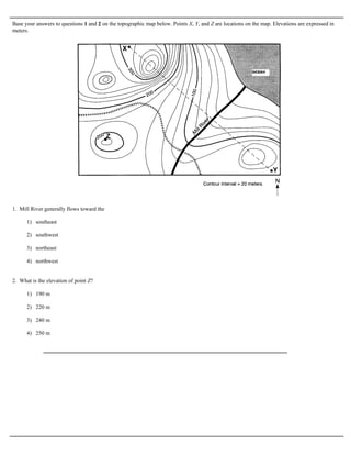
  • 1. Base your answers to questions 1 and 2 on the topographic map below. Points X, Y, and Z are locations on the map. Elevations are expressed in meters. 1. Mill River generally flows toward the 1) southeast 2) southwest 3) northeast 4) northwest 2. What is the elevation of point Z? 1) 190 m 2) 220 m 3) 240 m 4) 250 m
  • 2. Base your answers to questions 3 and 4 on the maps below. Points A, B, C, X, and Y are locations on the topographic map. The small map identifies the New York State region shown in the topographic map. 3. What is the elevation of point A on the topographic map? 1) 1,700 ft 2) 1,650 ft 3) 1,600 ft 4) 1,550 ft
  • 3. 4. What is the approximate gradient between point X and point Y? 1) 100 ft/mi 2) 250 ft/mi 3) 500 ft/mi 4) 1,000 ft/mi 5. A stream has a source at an elevation of 1,000. meters. It 7. What is the elevation of the highest contour line shown on ends in a lake that has an elevation of 300. meters. If the the map below? lake is 200. kilometers away from the source, what is the average gradient of the stream? 1) 1.5 m/km 2) 3.5 m/km 3) 10. m/km 4) 15 m/km 6. The diagram below is a contour map. Between which two points is the slope of the hill steepest? 1) 10,000 feet 2) 10,688 feet 3) 10,700 feet 4) 10,788 feet 1) A and B 2) B and C 3) C and D 4) A and D
  • 4. 8. The map below represents an elevation field. What is the approximate gradient between point A and point B? 1) 0.5 m/km 2) 2.0 m/km 3) 3.0 m/km 4) 4.0 m/km
  • 5. Base your answers to questions 9 through 11 on the contour map below. Points A, B, C, D, X, and Y are locations on the map. Elevations are expressed in feet. The maximum elevation of Basket Dome is indicated at point X. 9. In which general direction does Tenaya Stream flow? 1) southeast to northwest 2) northwest to southeast 3) southwest to norheast 4) northeast to southwest
  • 6. 10. The highest elevation on the map is at point 1) X 2) Y 3) C 4) D 11. The highest elevation of Basket Dome 40 years ago was measured at 7,600 feet. What is the rate of change in elevation for this area? 1) 0.6 in/yr 2) 1.7 in/yr 3) 24 in/yr 4) 40 in/yr Base your answers to questions 12 through 15 on the contour map of an island below. Points A through G represent locations on the island. Elevations are in meters. 12. Which point is located on the steepest slope? 1) F 2) B 3) C 4) D
  • 7. 13. In which direction does the Cinder River flow? 1) southeast 2) southwest 3) northeast 4) northwest 14. What is the contour interval for this map? 1) 10 m 2) 15 m 3) 20 m 4) 25 m 15. Which two points have the same elevation? 1) G and F 2) B and D 3) C and D 4) G and C
  • 8. Answer Key HW 106 Earth Science Mapping Questions [Oct 06, 2009] 1. 3 2. 2 3. 1 4. 4 5. 2 6. 2 7. 3 8. 2 9. 4 10. 3 11. 1 12. 3 13. 4 14. 3 15. 3