2013 05-01-portfolio-management-at-a-glance-sheets
•Als PPTX, PDF herunterladen•
0 gefällt mir•442 views

The document discusses portfolio management of federal geospatial data assets according to OMB guidance. Portfolio management coordinates data assets and investments to efficiently support national priorities by reducing duplication, increasing accessibility, and enabling shared services across government. Datasets are organized into themes which are managed by theme leads and dataset managers using practices to improve data quality and access.

Empfohlen
Empfohlen
Weitere ähnliche Inhalte
Ähnlich wie 2013 05-01-portfolio-management-at-a-glance-sheets
Ähnlich wie 2013 05-01-portfolio-management-at-a-glance-sheets (20)
Kürzlich hochgeladen
Kürzlich hochgeladen (20)
2013 05-01-portfolio-management-at-a-glance-sheets
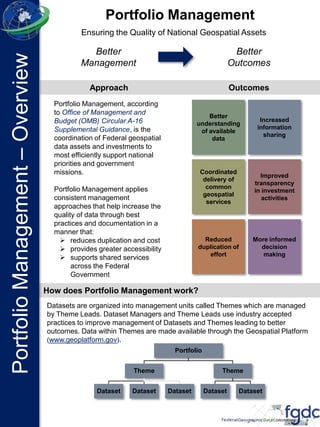
- 1. Portfolio Management, according to Office of Management and Budget (OMB) Circular A-16 Supplemental Guidance, is the coordination of Federal geospatial data assets and investments to most efficiently support national priorities and government missions. Portfolio Management applies consistent management approaches that help increase the quality of data through best practices and documentation in a manner that: reduces duplication and cost provides greater accessibility supports shared services across the Federal Government Better Management Better Outcomes Approach Outcomes Better understanding of available data Increased information sharing More informed decision making Reduced duplication of effort Improved transparency in investment activities Coordinated delivery of common geospatial services Datasets are organized into management units called Themes which are managed by Theme Leads. Dataset Managers and Theme Leads use industry accepted practices to improve management of Datasets and Themes leading to better outcomes. Data within Themes are made available through the Geospatial Platform (www.geoplatform.gov). How does Portfolio Management work? Portfolio Theme Dataset Dataset Dataset Theme Dataset Dataset Portfolio Management Ensuring the Quality of National Geospatial Assets PortfolioManagement–Overview
- 2. National Geospatial Data Asset (NGDA) Themes are organizational constructs under which Datasets are grouped and managed. The 16 Themes are: • Biota • Cadastre • Climate and Weather • Cultural Resources • Elevation • Geodetic Control • Geology • Governmental Units, and Administrative and Statistical Boundaries • Imagery • Land Use-Land Cover • Real Property • Soils • Transportation • Utilities • Water – Inland • Water – Oceans & Coasts Who manages the Datasets and Themes? Dataset Managers provide information to their Theme Lead for management and reporting. For more information go to www.FGDC.gov/PortfolioManagement What will the Portfolio ultimately consist of? What are NGDA Themes? Dataset Manager provide coordination and standards for Datasets at a national level. Dataset Managers use the Geospatial Data Lifecycle to manage their Datasets. Dataset Managers Theme Leads provide cross- agency leadership and coordination for the Theme. Theme leads will submit Theme reports to the FGDC. Theme Leads Here is an example of how a Theme within the Portfolio will be set up. PortfolioManagement–Overview National Watershed Dataset Water Theme National Wetlands Dataset National Hydrography Dataset NGDA Portfolio
- 3. This page intentionally left blank as a spacer.
- 4. The NGDA Portfolio Management Process The Portfolio Management Process The Portfolio Management Process includes an annual review of assets, consistent management of current data, and annual progress reporting. Inventory – Identify existing geospatial datasets that may be considered National Geospatial Data Assets (NGDAs). The FGDC Steering Committee must know what geospatial data exist and how they support the business requirements of the Federal Government and its partners. Select – Determine if the datasets are NGDA Datasets and if they should become part of the Portfolio. Inclusion will be based on the following criteria for individual Datasets: • Used by multiple agencies and partners; • Needed to support Presidential priorities as expressed by OMB; • Required to meet shared mission goals of multiple Federal agencies; or • Expressly required by statutory mandates. Manage – Develop and manage Datasets per the OMB Circular A-16 Supplemental Guidance. This phase of consists of activities at both the Theme and Dataset levels. These include an initial baseline assessment, implementation of the data lifecycle, and preparation of an annual Portfolio Summary Report. Evaluate/ Monitor – Develop Dataset, Theme, and Portfolio summary reports that capture plans, milestones, and progress of the Portfolio. Metrics will provide a comprehensive picture of the Portfolio allowing better enterprise-level decision- making Identify and Execute – Develop NGDA Theme and NGDA Dataset improvement, funding, and priorities. Annual recommendations are made on Portfolio actions. Inventory Select Manage Evaluate / Monitor Identify & Execute A key goal of Portfolio Management is to enable the FGDC Steering Committee to make informed decisions on setting both short- and long-term priorities on Themes and Datasets as well as cross-agency collaboration targets for Dataset development and funding. PortfolioManagement–Process
- 5. The Key Roles within Portfolio Management Theme Leads are responsible for the coordination and integration of multiple Datasets that are often managed in separate agencies. Theme Leads coordinate with their respective Dataset Managers to provide overall management for the Datasets associated with the Theme. This will ensure that all relevant Datasets associated with a particular Theme effectively support the business processes reliant on them; and that they are produced in the most cost effective manner. Each Theme Lead also coordinates with other Theme Leads to ensure that Datasets applicable to more than one Theme are effectively co-developed. In short, Theme Leads are the master coordinators that guide the overall Portfolio Management process. Dataset Managers use the Geospatial Data Lifecycle to plan, develop, maintain, evolve, and archive the NGDA Dataset(s) for which they are responsible. They will also use the Geospatial Data Lifecycle and the associated evaluation criteria to provide Dataset reports to the Theme Lead. The Theme Leads compile Dataset reports to look across the Theme and identify potential coordination opportunities, efficiencies, and investment and development priorities. These outputs are communicated to the FGDC for consideration in annual investment planning. For more information go to www.FGDC.gov/PortfolioManagement PortfolioManagement–Process
- 6. This page intentionally left blank as a spacer.
- 7. Stage 1. Define: Characterization of data requirements based upon business-driven user needs. Stage 2. Inventory/Evaluate: Creation and publication of a detailed list of data assets and data gaps (both internal and external) as they relate to business-driven user needs. Stage 3. Obtain: Identify the mechanism(s) for the collection, purchase, conversion, transformation, sharing, exchanging, or creation of geospatial data that were selected to meet the business needs. Stage 4. Access: Making data produced known and retrievable to the community through documentation and discovery mechanisms so the users can meet their business requirements. Stage 5. Maintain: Ongoing processes and procedures for data operation and maintenance to ensure that the data continue to meet business requirements. Stage 6. Use/Evaluate: Ongoing assessment, validation, and potential enhancement of data to meet user needs and business requirements. Stage 7. Archive: Required retention of data and the data’s retirement into long- term storage. Outcomes • Better understanding of Dataset quality • Identification of best management practices • Availability of geospatial data to support business processes and operations • Strengthens partnerships and coordination across all levels of government to increase cost efficiency and return on investment • Improved efficiencies in addressing Federal and national priorities, and enhancing citizen service Define Inventory / Evaluate Obtain AccessMaintain Use/ Evaluate Archive Geospatial Data Lifecycle The Dataset Management Process The Geospatial Data Lifecycle is the management approach adopted by Federal agencies to ensure the quality and reliability of National Geographic Data Assets (NGDA) Datasets. PortfolioManagement–Datasets
- 8. Requirements for Managing Data For more information go to www.FGDC.gov/PortfolioManagement PortfolioManagement–Datasets Dataset Managers implement the Geospatial Data Lifecycle to ensure that data are trustworthy and useful and that data going to the Geospatial Platform are current and reliable. Additionally, Dataset Managers submit annual reports on their Datasets to their respective Theme Lead. Theme Lead Dataset Manager Dataset Manager Dataset Manager Annual reports Dataset Management involves implementing the Geospatial Data Lifecycle, promoting the maturity of Datasets, monitoring key indicators for annual dataset reports, and providing status of performance measures. Regular evaluation of Datasets, through annual dataset reports and Thematic Subcommittee discussions, will ensure that Datasets are current and relevant.
Hinweis der Redaktion
- Version May 1, 2013