Online Mapping Support - Age Advantage Association
Related projects
1. Related
Projects
The
projects
examples
listed
below
are
all
about
mobile
guides,
some
of
them
are
mobile
campus
guides
which
is
relevant
to
this
project,
some
of
them
are
more
about
mobile
guides
for
exhibitions
in
museums,
mobile
guides
for
the
walking
trails
in
a
certain
city…
however,
Most
of
these
projects
have
really
good
user
interface
design
and
focused
on
promoting
user
interaction
during
the
visiting,
although
not
all
of
them
have
similar
idea
as
this
project,
their
ideas
and
designs
all
inspired
this
project
–mobile
guides
on
campus.
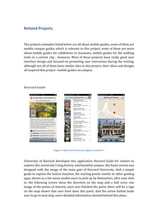
Harvard
Guide
Figure
1
Harvard
University
App
Screenshot
1
University
of
Harvard
developed
this
application
Harvard
Guide
for
visitors
to
explore
this
university’s
long
history
and
beautiful
campus;
the
home
screen
was
designed
with
the
image
of
the
main
gate
of
Harvard
University.
And
a
simple
guide
to
explain
the
button
function,
the
starting
points
similar
to
other
guiding
apps,
shown
as
a
list
menu
enable
users
to
pick
up
by
themselves,
after
user
click
in,
the
following
screen
show
the
direction
on
the
map
and
a
half
scree
size
image
of
the
points
of
interest,
once
user
finished
the
point,
there
will
be
a
sign
on
the
map
shown
that
user
have
done
this
point.
And
the
arrow
button
leads
user
to
go
to
next
step,
more
detailed
information
showed
behind
this
place.
2.
Figure
2
Harvard
University
App
Screenshot
2
• The
info
button
shows
the
general
description
of
the
stop;
• The
inside
and
out
button
shows
an
insider’s
view
of
Harvard,
this
is
a
really
good
feature
and
other
application
usually
do
not
this
function,
university
is
a
typical
place
that
some
of
the
area
may
not
open
to
the
public,
this
feature
is
very
useful
for
the
visitors
who
cannot
access
to
the
inside
area.
• The
Fast
facts
button
documents
the
interesting
facts
and
trivia
once
happened
in
this
place,
many
of
them
have
an
interesting
image
to
explain
the
moment
as
well,
it
calls
back
alumni’s
memory
and
help
new
students
learn
better
about
the
place.
• Innovation
also
for
documenting
big
events
once
happened
here,
help
user
to
understand
more
about
some
significance
place.
• History
is
there
to
tell
visitors
highlights
and
stories.
A
lot
of
videos
were
put
into
these
functions;
many
of
them
have
back
ground
music
help
users
to
have
a
nice
experience
of
the
certain
moment
and
certain
place.
Tree
Tour
in
Oregon
State
University
OSU
designed
and
developed
this
application
to
promote
the
awareness
of
the
variety
kind
of
trees
on
campus;
the
interface
is
clean
and
tidy
with
green,
white
and
grey
as
their
basic
three
colors,
very
close
to
nature
forest
color.
3.
Figure
3
OSU
App
Screenshot
1
The
tour
consists
of
two
separate
tours:
the
longer
one
MU
Grand
Tour
takes
45
minute
and
the
MU
short
Tour
15
minutes.
Once
visitor
start
the
tour,
the
detailed
information
such
as
10
stops,
797
ft.
distance
will
be
shown
on
the
screen,
the
app
lead
visitors
step
by
step,
two
buttons
Tour
and
Map
enable
user
to
switch
between
direction
to
get
to
the
points
of
interest
and
the
description
of
the
tree.
The
map
shows
an
overview
position
of
trees
with
number
and
stops
to
help
visitors
find
the
place.
Figure
4
OSU
App
Screenshot
2
The
main
menu
consists
of
three
parts,
the
Tree
Tour
which
is
mentioned
above
and
the
open
map,
displayed
a
sidelight
map
for
campus
with
small
tree
icons
located
in
it,
each
small
icons
enable
visitor
to
click
and
learn
more
since
they
all
connected
to
the
information
page.
4. Reference
enables
visitors
to
search
and
learn
the
common
name
and
the
botanical
name
of
these
trees,
detailed
information
include
the
leaf
type
the
flower
information
and
whether
native
to
Oregon
or
not.
Ennis
Walking
Trails
Figure
5Ennis
App
Screenshot
1
The
town
of
Ennis
is
full
of
marvelous
public
sculptures
and
works
of
art.
This
application
contains
large
amount
of
information
about
Ennis
to
help
visitors
learn
and
explore
this
town.
This
walking
trail
guide
consists
of
four
historical
walking,
and
categorized
into
different
colors,
each
of
them
has
an
introduction
about
the
history
and
story
information
behind,
as
well
as
the
distance
and
time
it
will
need
to
finish
the
walking
trail.
5.
Figure
6
Ennis
App
Screenshot
2
Clicking
into
the
points
of
interest
may
be
able
to
see
the
number
of
interests
in
the
walking
trail,
users
can
choose
take
me
to
this
point
to
get
the
directions
to
the
place
through
GPS
map,
sharing
the
point
of
interest
to
friend
on
Facebook,
or
take
a
photo
to
send
by
email,
some
of
the
interest
have
audio
guide.
MIT
campus
tour
Figure
7
MIT
App
Screenshot
1
MIT
mobile
campus
guide
is
the
project
that
has
some
similar
ideas
to
this
project
especially
for
some
walking
trails
on
campus.
It
aims
to
let
visitors
have
a
nice
experience
and
learn
the
history
of
different
parts
on
MIT
campus;
the
information
includes
MIT’s
architecture,
artwork,
facilities
etc.
Self-‐guided
tour
6. and
guided
tours
are
both
provide
on
the
home
screen,
guided
tours
connected
to
the
home
page
of
MIT
website,
include
information
about
the
pickup
points
on
campus
and
tour
guide
meet
up
time.
Self-‐guided
tour
enables
visitor
to
pick
up
starting
point,
the
app
will
include
some
recommend
points
to
show
visitors
and
step-‐by-‐step
guidance
to
guide
them.
Figure
8
MIT
App
Screenshot
2
Once
visitor
start
the
tour,
detail
information
will
be
shown
on
the
screen
step
by
step,
leading
visitors
the
direction
to
the
next
stop,
the
timeline
at
the
bottom
of
the
screen
shows
the
number
of
places
have
been
visited
and
there
is
a
button
in
the
middle
of
the
timeline
enable
user
to
switch
between
the
real
map
and
the
detailed
information.
Some
side
trips
are
also
shown
in
the
detailed
information,
visitors
can
have
their
own
flexible
walking
trails.
When
the
tour
ended,
the
last
screen
shows
visitor
the
campus
information,
enable
visitor
to
send
feedback
through
their
smart
phone,
and
also
help
visitors
to
find
a
place
to
eat.
Explorer
Tsai
and
Sung
(2012)
argues
in
their
article
Mobile
Applications
and
Museum
Visitation
that
way
finding
in
the
large
museum
is
a
particular
big
challenge
for
visitors,
many
visitors
these
years
have
the
tendency
to
plan
their
visit
before
they
arrive.
They
may
pick
up
some
points
if
those
POIs
really
attract
them,
but
the
problem
is
imagine
if
they
pick
up
two
points
and
they
are
not
sure
the
amount
of
time
they
will
spend
there,
and
the
way
they
will
get
from
one
exhibition
to
another
one,
what
can
they
do
except
ask
the
staffs
in
the
museum
or
find
the
way
by
themselves.
7. They
gave
an
example
of
American
Museum
of
Natural
History,
in
order
to
help
visitors
solve
this
problem:
they
developed
a
mobile
application
explorer,
and
add
the
feature
“My
Tour”.
Figure
9
Explorer
Screenshot
1
The
interface
above
is
the
application
Explorer;
the
first
screen
contains
four
parts
of
information:
find
exhibition,
museum
tours,
food
&
shops
and
restroom
&
exit.
The
list
menus
under
the
popular
category
list
all
the
popular
exhibitions.
They
all
contain
the
feature
of
locating
current
place
and
then
sharing
to
friends,
add
the
bookmark
and
mark
as
visited.
The
interface
list
below
is
the
map
function.
All
the
exhibition
information
shows
by
different
floors,
the
infographic
tells
visitors
the
overview
location
of
in
the
museum.
Figure
10
Explorer
Screenshot
2
The
following
interface
shows
the
feature
“My
Tour”,
the
add
Exhibit
button
enables
visitors
to
add
their
preferred
exhibit
from
all
the
exhibits
in
the
museum,
in
this
way
visitors
build
up
their
personal
tour.
8. This
feature
uses
location-‐aware
mobile
technologies
to
provide
turn-‐by-‐turn
instructions
between
two
points
within
the
museum,
allowing
visitors
to
design
their
own
visitation
routes.
Tsai
and
Sung
(2012)
Figure
11
Explorer
Screenshot
3
Although
the
Explorer
was
designed
for
the
museum,
many
of
the
design
ideas
still
inspired
this
project,
for
instance:
how
they
allocate
their
information
on
the
home
screen
to
meet
the
users’
requirement
is
quite
important,
they
add
a
category
named
‘popular’
to
list
all
the
popular
exhibits
enable
visitors
to
find
them
easily,
they
promoted
user
interaction
very
well
because
they
enable
visitors
to
build
their
own
tours.