SlideShare ist ein Scribd-Unternehmen logo
1 von 84
University of Limerick Campus Trails
Art Trail and Flora and Fauna Trail

Yuki Jiang


Table	
  of	
  Contents	
  
Abstract	
  ....................................................................................................................	
  5	
  
1.Introduction	
  ...........................................................................................................	
  6	
  
1.1	
  Introduction	
  .......................................................................................................................................................	
  6	
  
1.1.1	
   Project	
  Idea	
  
................................................................................................................................................	
  6	
  
1.1.2	
  Motivation	
  ......................................................................................................................................................	
  6	
  
1.1.3	
  Structure	
  .........................................................................................................................................................	
  6	
  
1.2	
  The	
  project	
  .........................................................................................................................................................	
  6	
  
1.2.1	
  What	
  is	
  it?	
  .......................................................................................................................................................	
  6	
  
1.2.2	
  Why	
  is	
  it	
  important?	
  
...................................................................................................................................	
  7	
  
1.2.2	
  Who	
  is	
  it	
  for?	
  ..................................................................................................................................................	
  7	
  
1.2.3	
  Where	
  will	
  it	
  be	
  used?	
  ................................................................................................................................	
  7	
  
1.2.4	
  How	
  will	
  it	
  be	
  made?	
  ..................................................................................................................................	
  7	
  
2	
  Research	
  ................................................................................................................	
  8	
  
2.1Introduction	
  ........................................................................................................................................................	
  8	
  
2.1.1	
  Research	
  questions	
  .....................................................................................................................................	
  8	
  
2.2	
  Background	
  literature	
  ...................................................................................................................................	
  8	
  
2.2.1	
  Using	
  Mobile	
  Technology	
  for	
  guidance	
  
..............................................................................................	
  8	
  
2.2.2	
  Google	
  Maps	
  in	
  the	
  campus	
  mobile	
  guide	
  ........................................................................................	
  9	
  
2.2.3	
  Localization	
  and	
  guidance	
  for	
  indoor	
  and	
  outdoor	
  using	
  smart	
  phone	
  ...........................	
  10	
  
2.2.4	
  Evaluation	
  criteria	
  
....................................................................................................................................	
  12	
  
2.2.5	
  How	
  to	
  do	
  the	
  guidance	
  ..........................................................................................................................	
  13	
  
2.2.6	
  Notification	
  system	
  ...................................................................................................................................	
  13	
  
2.2.6	
  Interact	
  with	
  users	
  ....................................................................................................................................	
  14	
  
2.3	
  Related	
  Projects	
  ............................................................................................................................................	
  17	
  
2.3.1	
  Harvard	
  Guide	
  ............................................................................................................................................	
  17	
  
2.3.2	
  Tree	
  Tour	
  in	
  Oregon	
  State	
  University	
  
...............................................................................................	
  19	
  
2.3.3	
  Ennis	
  Walking	
  Trails	
  
................................................................................................................................	
  21	
  
2.3.4	
  MIT	
  campus	
  tour	
  .......................................................................................................................................	
  22	
  
2.3.5	
  Explorer	
  .........................................................................................................................................................	
  24	
  
2.4	
  Methodology/	
  User	
  studies	
  ......................................................................................................................	
  26	
  
2.5	
  Prototypes	
  .......................................................................................................................................................	
  26	
  
2.6	
  Technologies	
  involved	
  ................................................................................................................................	
  27	
  
3	
  Design	
  Process	
  .....................................................................................................	
  27	
  
3.1	
  Introduction	
  ....................................................................................................................................................	
  27	
  
3.2	
  Methodology	
  ...................................................................................................................................................	
  27	
  
3.3	
  Understand	
  Users	
  .........................................................................................................................................	
  28	
  
3.4	
  Drawing	
  Requirements	
  ..............................................................................................................................	
  30	
  
3.5	
  Prototyping	
  .....................................................................................................................................................	
  30	
  
3.5.1	
  Organizing	
  the	
  Information	
  .................................................................................................................	
  30	
  
3.5.2	
  Problems	
  I	
  met	
  ............................................................................................................................................	
  34	
  
3.5.2	
  Paper	
  Prototyping	
  
.....................................................................................................................................	
  35	
  
3.5.3	
  User	
  Test	
  and	
  Improvement	
  .................................................................................................................	
  38	
  
3.6	
  User	
  Interface	
  Design	
  
..................................................................................................................................	
  39	
  
3.6.1	
  UI	
  Design	
  Idea	
  .............................................................................................................................................	
  39	
  
3.6.2	
  Overall	
  Interface	
  Demo	
  ...........................................................................................................................	
  42	
  
4	
  Development	
  Process	
  ...........................................................................................	
  44	
  
4.1	
  Introduction	
  ....................................................................................................................................................	
  44	


4.2	
  Connect	
  Homepage	
  with	
  Art	
  Trail	
  and	
  Flora	
  &	
  Fauna	
  Trail	
  ......................................................	
  44	
  
4.3	
  Switch	
  Between	
  Screens	
  ............................................................................................................................	
  46	
  
4.4	
  Connect	
  “Like”	
  Button	
  with	
  Facebook	
  Campus	
  Trails	
  Page	
  .......................................................	
  47	
  
4.4.1	
  Set	
  up	
  Facebook	
  Page	
  for	
  UL	
  campus	
  trails	
  ..................................................................................	
  47	
  
4.4.2	
  Connect	
  “like’’	
  button	
  to	
  the	
  relevant	
  photo	
  on	
  Facebook	
  ......................................................	
  48	
  
4.5	
  Connect	
  “	
  share”	
  Button	
  with	
  Social	
  Network	
  .................................................................................	
  49	
  
4.6	
  Location	
  Service	
  ............................................................................................................................................	
  50	
  
4.6.1	
  Create	
  Art	
  Trail	
  and	
  Flora	
  and	
  Fauna	
  Trail	
  map	
  in	
  Google	
  Maps	
  .......................................	
  51	
  
4.6.2	
  Connect	
  “	
  Location”	
  Button	
  with	
  Google	
  Map	
  ..............................................................................	
  52	
  

5	
  Evaluation	
  ............................................................................................................	
  55	
  
5.1	
  Task	
  List	
  
............................................................................................................................................................	
  55	
  
5.2	
  Conditions	
  of	
  Testing	
  ..................................................................................................................................	
  56	
  
5.3	
  Recruitment	
  of	
  Users	
  ..................................................................................................................................	
  56	
  
5.4	
  Observation	
  Notes	
  ........................................................................................................................................	
  57	
  
5.5	
  Result	
  of	
  Observation	
  .................................................................................................................................	
  63	
  
5.6	
  Improvement	
  after	
  evaluation	
  ................................................................................................................	
  64	
  
6	
  Project	
  Plan	
  Timeline	
  
............................................................................................	
  65	
  
7	
  Conclusion	
  and	
  Future	
  Plans	
  .................................................................................	
  66	
  
References	
  ..............................................................................................................	
  68	
  
Appendix	
  n.	
  1	
  Questions	
  for	
  Interview	
  .......................................................................................................	
  71	
  
Appendix	
  n.	
  2	
  Task	
  List	
  .....................................................................................................................................	
  72	
  
Appendix	
  n.	
  3	
  Key	
  Codes	
  ...................................................................................................................................	
  74	
  
Appendix	
  n.	
  3	
  Project	
  Timeline	
  ......................................................................................................................	
  84	


Table	
  of	
  Figures	
  
Figure	
  1:	
  Evaluation	
  criteria	
  used	
  to	
  review	
  mobile	
  guide	
  projects(Kenteris	
  et	
  al.	
  
2011)	
  ....................................................................................................................................................................	
  12	
  
Figure	
  2:	
  The	
  Babble	
  interface	
  from	
  Book	
  "Interaction	
  Design"	
  ................................................	
  16	
  
Figure	
  3:	
  Harvard	
  University	
  App	
  Screenshot	
  1	
  ................................................................................	
  17	
  
Figure	
  4:	
  Harvard	
  University	
  App	
  Screenshot	
  2	
  ................................................................................	
  18	
  
Figure	
  5:	
  OSU	
  App	
  Screenshot	
  1	
  ...............................................................................................................	
  19	
  
Figure	
  6:	
  OSU	
  App	
  Screenshot	
  2	
  ...............................................................................................................	
  20	
  
Figure	
  7:	
  Ennis	
  App	
  Screenshot	
  1	
  ............................................................................................................	
  21	
  
Figure	
  8:	
  Ennis	
  App	
  Screenshot	
  2	
  ............................................................................................................	
  22	
  
Figure	
  9:	
  MIT	
  App	
  Screenshot	
  1	
  ...............................................................................................................	
  22	
  
Figure	
  10:	
  MIT	
  App	
  Screenshot	
  2	
  .............................................................................................................	
  23	
  
Figure	
  11:	
  Explorer	
  Screenshot	
  1	
  
.............................................................................................................	
  24	
  
Figure	
  12:	
  Explorer	
  Screenshot	
  2	
  
.............................................................................................................	
  25	
  
Figure	
  13:	
  Explorer	
  Screenshot	
  3	
  
.............................................................................................................	
  25	
  
Figure	
  14	
  The	
  User	
  Centered	
  Design	
  Process	
  .....................................................................................	
  28	
  
Figure	
  15:	
  Information	
  for	
  North	
  Bank	
  Trail	
  and	
  for	
  Art	
  Trail	
  ...................................................	
  35	
  
Figure	
  16:	
  	
  Information	
  for	
  South	
  Bank	
  Trail	
  .....................................................................................	
  35	
  
Figure	
  17:	
  Paper	
  prototype	
  screen1	
  and	
  screen2	
  .............................................................................	
  36	
  
Figure	
  18:	
  Paper	
  prototype	
  screen3	
  and	
  screen4	
  .............................................................................	
  36	
  
Figure	
  19:	
  Paper	
  prototype	
  screen5	
  and	
  screen6	
  .............................................................................	
  37	
  
Figure	
  20:	
  User	
  Testing1	
  and	
  User	
  Testing2	
  .......................................................................................	
  38	
  
Figure	
  21:	
  Art	
  Trail	
  Screens	
  ........................................................................................................................	
  39	


3	
  
Figure	
  22:	
  Interface	
  Design	
  Ideas	
  ............................................................................................................	
  41	
  
Figure	
  23:	
  Flora	
  and	
  Fauna	
  Trail	
  Screens	
  Demo	
  ...............................................................................	
  42	
  
Figure	
  24:	
  Art	
  Trail	
  Screens	
  Demo	
  ..........................................................................................................	
  43	
  
Figure	
  25:	
  Click	
  Effect	
  Screens	
  Demo	
  .....................................................................................................	
  43	
  
Figure	
  26:	
  Connecting	
  buttons	
  with	
  each	
  page	
  ..................................................................................	
  45	
  
Figure	
  27:	
  Relevant	
  codes	
  for	
  connecting	
  buttons	
  with	
  each	
  page	
  ...........................................	
  45	
  
Figure	
  28:	
  Switch	
  Between	
  Screens	
  ........................................................................................................	
  46	
  
Figure	
  29:	
  Relevant	
  codes	
  for	
  switching	
  Between	
  Screens	
  ..........................................................	
  47	
  
Figure	
  30:	
  UL	
  campus	
  Trails	
  Facebook	
  Page	
  .......................................................................................	
  47	
  
Figure	
  31:	
  Like	
  Button	
  ..................................................................................................................................	
  48	
  
Figure	
  32:	
  Relevant	
  Codes	
  for	
  Like	
  Button	
  (Stackoverflow	
  Question	
  
4810803(2013))	
  ..............................................................................................................................................	
  49	
  
Figure	
  33:	
  Share	
  Button	
  ...............................................................................................................................	
  49	
  
Figure	
  34:	
  Relevant	
  codes	
  for	
  Share	
  Button	
  ........................................................................................	
  50	
  
Figure	
  35:	
  Create	
  Art	
  Trail	
  Map	
  ................................................................................................................	
  51	
  
Figure	
  36:	
  Create	
  Flora	
  and	
  Fauna	
  Trail	
  Map	
  .....................................................................................	
  51	
  
Figure	
  37:	
  Turn	
  on	
  Google	
  Maps	
  Android	
  API	
  v2	
  service	
  ..............................................................	
  52	
  
Figure	
  38:	
  	
  Creating	
  Android	
  Key	
  for	
  API	
  Project	
  .............................................................................	
  52	
  
Figure	
  39:	
  Android	
  Key	
  for	
  API	
  Project	
  is	
  created	
  ............................................................................	
  53	
  
Figure	
  40:	
  “Location	
  me”	
  button	
  ..............................................................................................................	
  53	
  
Figure	
  41:	
  	
  Relevant	
  code	
  for	
  “Location”	
  button	
  ...............................................................................	
  54	
  
Figure	
  42:	
  User	
  2	
  following	
  the	
  app	
  arriving	
  at	
  the	
  Chancellor’s	
  Walk	
  ...................................	
  61	
  
Figure	
  43:	
  User	
  1	
  was	
  reading	
  the	
  introduction	
  at	
  the	
  stop	
  of	
  The	
  Water	
  Colour	
  
Society	
  of	
  Ireland	
  National	
  Collection	
  ....................................................................................................	
  61	
  
Figure	
  44:	
  User	
  1	
  was	
  using	
  “locate	
  me”	
  feature	
  and	
  following	
  the	
  map	
  to	
  
Foundation	
  Building	
  ......................................................................................................................................	
  62	
  
Figure	
  45:	
  User	
  3	
  was	
  following	
  the	
  direction	
  sign	
  to	
  the	
  Bourn	
  Vincent	
  Gallery	
  in	
  
the	
  Foundation	
  Building	
  
...............................................................................................................................	
  62	


4	
  
Abstract	


This	
   thesis	
   is	
   about	
   my	
   final	
   project	
   as	
   a	
   postgraduate	
   of	
   Interactive	
   Media	
   in	
  
University	
   of	
   Limerick.	
   This	
   project	
   documents	
   the	
   design	
   and	
   development	
   of	
  
University	
  of	
  Limerick	
  Campus	
  Trails.	
  The	
  aim	
  of	
  this	
  project	
  is	
  to	
  build	
  a	
  mobile	
  
guide	
   application	
   to	
   guide	
   users	
   on	
   campus;	
   to	
   investigate	
   the	
   information	
  
required	
  by	
  students,	
  staff	
  and	
  visitors;	
  and	
  to	
  explore	
  the	
  technologies	
  involved	
  in	
  
the	
  project.	


5	


1.Introduction	
  
1.1	
  Introduction	
  
This	
   report	
   documents	
   the	
   research	
   and	
   development	
   of	
   my	
   final	
   year	
   project	
  
investigating	
  mobile	
  guides	
  on	
  campus,	
  with	
  the	
  focus	
  on	
  walking	
  and	
  art	
  trails.	


1.1.1

Project Idea

The	
  aim	
  of	
  this	
  project	
  is	
  to	
  build	
  a	
  mobile	
  guide	
  application	
  to	
  guide	
  users	
  for	
  a	
  
walking	
  trail	
  and	
  art	
  trail	
  on	
  campus;	
  to	
  investigate	
  the	
  information	
  required	
  by	
  
students,	
  staff	
  and	
  visitors;	
  and	
  to	
  explore	
  the	
  technologies	
  involved	
  in	
  the	
  project.	
  
1.1.2 Motivation
Because	
   modern	
   lifestyle	
   highly	
   relies	
   on	
   the	
   smart	
   phone,	
   the	
   motivation	
   of	
   the	
  
project	
   is	
   to	
   explore	
   the	
   technology	
   and	
   process	
   of	
   how	
   modern	
   lifestyle	
  
corresponds	
   with	
   personal	
   smart	
   phone	
   device	
   and	
   make	
   good	
   use	
   of	
   the	
  
information	
  on	
  campus,	
  in	
  order	
  to	
  self-­‐guide	
  and	
  educate	
  visitors	
  in	
  both	
  indoor	
  
and	
  outdoor	
  environment	
  for	
  walking	
  trail	
  and	
  art	
  trail.	
  
1.1.3 Structure
The	
   project	
   main	
   consists	
   of	
   two	
   parts:	
   	
   the	
   academic	
   research	
   and	
   the	
   design	
   &	
  
develop	
  process.	


1.2	
  The	
  project	
  
1.2.1 What is it?
This	
  project	
  concerns	
  the	
  design	
  and	
  development	
  of	
  a	
  mobile	
  guide	
  based	
  on	
  the	
  
Android	
  system	
  for	
  visitors	
  to	
  explore	
  a	
  self-­‐guided	
  walking	
  trail	
  and	
  art	
  trail	
  in	
  
university.	


6	
  
1.2.2 Why is it important?
This	
   project	
   will	
   investigate	
   and	
   explore	
   relations	
   between	
   modern	
   lifestyle	
   and	
  
popular	
   smart	
   phones	
   (Android	
   platform	
   in	
   this	
   case),	
   and	
   how	
   they	
   correspond	
  
with	
   each	
   other.	
   And	
   apply	
   these	
   techniques	
   and	
   process	
   on	
   mobile	
   guides	
   on	
  
campus	
  to	
  guide	
  visitors.	
  
1.2.2 Who is it for?
This	
   project	
   is	
   mainly	
   designed	
   for	
   student,	
   staff	
   on	
   campus,	
   visitors	
   and	
   alumni	
  
who	
  wish	
  to	
  do	
  a	
  self-­‐guided	
  walking	
  trail	
  or	
  art	
  trail.	
  
1.2.3 Where will it be used?
This	
  application	
  is	
  designed	
  for	
  the	
  university	
  campus;	
  it	
  can	
  be	
  used	
  in	
  a	
  variety	
  of	
  
places	
   on	
   and	
   around	
   campus.	
   For	
   instance	
   it	
   can	
   be	
   used	
   to	
   guide	
   people	
   when	
  
exploring	
  walking	
  trails	
  on	
  campus,	
  show	
  them	
  around	
  the	
  art	
  gallery,	
  visit	
  some	
  
sculptors	
   and	
   arboretum	
   around	
   campus,	
   guide	
   people	
   to	
   different	
   buildings	
  and	
  
also	
  help	
  them	
  learn	
  more	
  about	
  the	
  campus.	
  	
  
1.2.4 How will it be made?
The	
  process	
  of	
  making	
  such	
  an	
  Android	
  mobile	
  application	
  mainly	
  consists	
  of	
  two	
  
parts,	
  the	
  interface	
  design	
  and	
  the	
  implementation	
  (coding).	
  
To	
   design	
   the	
   interface	
   Adobe	
   Photoshop	
   will	
   be	
   used;	
   Axure	
   or	
   other	
   prototype	
  
tools12	
  will	
  be	
  required	
  for	
  prototyping	
  work.	
  	
  
To	
  implement	
  the	
  mobile	
  application,	
  Eclipse	
  platform	
  &	
  Android	
  SDK	
  will	
  be	
  used	
  
with	
  some	
  supplementary	
  APIs	
  (e.g.,	
  Google	
  Map	
  API)	
  as	
  well.	


1	
  http://www.fluidui.com/demos/	
  
2	
  https://proto.io/en/signup/	


7	
  
2	
  Research	
  	
  
2.1Introduction	
  
The	
   literature	
   review	
   addressed	
   two	
   main	
   issues:	
   mobile	
   application	
   design	
  
principles	
  for	
  the	
  mobile	
  guide	
  on	
  campus	
  and	
  related	
  technological	
  choices	
  during	
  
the	
  design	
  process	
  in	
  this	
  area.	


2.1.1 Research questions
•

How	
   to	
   promote	
   multi-­‐dimensional	
   interactions	
   when	
   self-­‐guiding	
   users	
   on	
  
campus?	
  (Millard	
  et	
  al.	
  2008)	
  

•

What	
  problems	
  should	
  be	
  taken	
  into	
  consideration	
  on	
  both	
  the	
  app	
  design	
  
process	
  and	
  develop	
  process?	
  (Kenteris	
  et	
  al.	
  2011)	
  

•

What	
  kind	
  of	
  positioning	
  technologies	
  and	
  map	
  technologies	
  should	
  be	
  used	
  
to	
   apply	
   on	
   indoor	
   and	
   outdoor	
   guidance,	
   and	
   also	
   how	
   to	
   do	
   the	
   self-­‐
guidance?	
  (Hammadi	
  et	
  al.	
  2012)	


2.2	
  Background	
  literature	


In	
  the	
  next	
  few	
  pages	
  I	
  will	
  review	
  some	
  of	
  the	
  key	
  contribution	
  in	
  the	
  area	
  of	
  using	
  
mobile	
  and	
  localization	
  technologies	
  in	
  guidance.	


2.2.1 Using Mobile Technology for guidance
“Mobile	
  technology	
  presents	
  the	
  opportunity	
  to	
  support	
  educational	
  visits	
  by	
  
providing	
  both	
  location-­‐based	
  information	
  and	
  guidance	
  through	
  this	
  information	
  
based	
  on	
  the	
  visitor’s	
  interests	
  and	
  needs.”	
  

(Naismith	
  et	
  al.	
  2005)	
  

In	
   their	
   project,	
   they	
   use	
   a	
   multimedia	
   context	
   to	
   help	
   users	
   read,	
   listen,	
   see	
   and	
  
explore	
  more	
  about	
  the	
  garden	
  tour.	
  They	
  stated	
  that	
  the	
  two	
  ideas	
  of	
  user	
  interests	
  
and	
  user	
  needs	
  are	
  very	
  important	
  in	
  mobile	
  guide	
  design.	
  It	
  is	
  very	
  common	
  that	
  
many	
  of	
  the	
  interesting	
  sites	
  or	
  collections	
  on	
  the	
  campus	
  may	
  not	
  be	
  noticed	
  by	


8	
  
the	
   students,	
   staff	
   or	
   visitors	
   on	
   campus,	
   though	
   there	
   are	
   lots	
   of	
   learning	
  
opportunities	
  within	
  these	
  places.	
  To	
  avoid	
  this,	
  the	
  mobile	
  guide	
  can	
  make	
  a	
  good	
  
use	
  of	
  this	
  information	
  to	
  guide	
  and	
  assist	
  visitors.	
  
Many	
  universities	
  or	
  national	
  galleries	
  have	
  lots	
  of	
  art	
  collections	
  in	
  their	
  own	
  art	
  
gallery.	
  To	
  connect	
  the	
  mobile	
  guide	
  with	
  social	
  media	
  (e.g.,	
  Facebook	
  or	
  Instagram)	
  
will	
   enrich	
   the	
   multi-­‐dimensional	
   interaction(Petrelli	
   and	
   Not	
   2005)	
   between	
  
visitors	
   and	
   information	
   of	
   the	
   on-­‐campus	
   art	
   collections	
   and	
   popular	
   visiting	
  
places	
  through	
  this	
  platform.	


2.2.2 Google Maps in the campus mobile guide
Kenteris(2011)argued	
   in	
   their	
   paper	
   that	
   the	
   map	
   usually	
   is	
   the	
   most	
   basic	
   and	
  
essential	
  part	
  in	
  mobile	
  tour	
  guide.	
  Most	
  of	
  the	
  similar	
  systems	
  use	
  maps	
  as	
  their	
  
central	
  part,	
  and	
  then	
  use	
  navigational	
  services	
  and	
  routing	
  services	
  based	
  on	
  the	
  
map.	
   Among	
   those	
   systems	
   some	
   of	
   the	
   campus	
   maps	
   were	
   designed	
   like	
   an	
  
infographic	
  to	
  show	
  information	
  around	
  campus,	
  this	
  kind	
  of	
  map	
  will	
  not	
  be	
  able	
  
to	
  interact	
  with	
  users;	
  some	
  of	
  the	
  maps	
  were	
  based	
  on	
  Google	
  Maps,	
  which	
  enable	
  
the	
  users	
  to	
  search	
  and	
  explore	
  on	
  it.	
  	
  
Most	
   of	
   the	
   maps	
   that	
   connect	
   to	
   Google	
   maps	
   in	
   the	
   mobile	
   guides	
   provide	
   the	
  
overview	
   and	
   detail	
   zoom	
   levels	
   features.	
   The	
   paper	
   Designing	
   LoL@,	
   a	
   Mobile	
  
Tourist	
  Guide	
  for	
  UMTS	
   presented	
   these	
   two	
   levels	
   by	
   giving	
   the	
   case	
   of	
   a	
   tourist	
  
map	
   guide	
   in	
   the	
   city	
   of	
   Vienna:	
   include	
   an	
   overview	
   map	
   of	
   walking	
   tour	
   in	
   the	
  
city,	
   and	
   related	
   sight-­‐seeing	
   information	
   on	
   some	
   view	
   point.	
   For	
   example,	
   the	
  
tourists	
  would	
  have	
  a	
  prior	
  experience	
  by	
  accessing	
  sightseeing	
  information	
  from	
  
the	
  mobile	
  guide	
  even	
  when	
  they	
  were	
  in	
  the	
  hotel,	
  and	
  during	
  visiting,	
  the	
  voice	
  
routing	
  service	
  will	
  read	
  the	
  step-­‐by-­‐step	
  routing	
  instructions	
  so	
  the	
  tourists	
  can	
  
concentrate	
   on	
   the	
   view/scenery.	
   They	
   are	
   also	
   capable	
   to	
   upload	
   photographs	
  
retrieved	
  from	
  the	
  built-­‐in	
  digital	
  camera	
  on	
  their	
  mobile	
  device	
  (Pospischil	
  et	
  al.	
  
2002).	
  
These	
   kinds	
   of	
   features	
   can	
   be	
   applied	
   on	
   the	
   mobile	
   guide	
   on	
   campus	
   as	
   well,	
   use	
  
Google	
  Maps	
  on	
  campus	
  as	
  the	
  central	
  part,	
  highlighting	
  some	
  popular	
  routes	
  for	


9	
  
visitors	
  to	
  do	
  a	
  pre-­‐visit.	
  	
  Adding	
  those	
  features	
  that	
  can	
  guide	
  users,	
  educate	
  users	
  
and	
  promote	
  interactions	
  between	
  users	
  and	
  POIs.	


2.2.3 Localization and guidance for indoor and outdoor using smart phone
Background	


The	
   positioning	
   technology	
   for	
   localization	
   can	
   roughly	
   be	
   divided	
   into	
   indoor	
   and	
  
outdoor	
  two	
  kinds	
  of	
  technology.	
  	
  
Google	
   Maps	
   is	
   being	
   used	
   in	
   most	
   mobile	
   apps	
   for	
   localization	
   or	
   positioning	
  
along	
   with	
   GPS	
   to	
   improve	
   accuracy,	
   and	
   Bolic	
   and	
   Donko	
   (2012)	
   pointed	
   out	
  
OpenStreetMap	
   as	
   an	
   alternative	
   of	
   Google	
   Maps,	
   OpenStreetMap	
   maps	
   are	
   from	
  
open	
  source	
  community,	
  though	
  it’s	
  not	
  as	
  common	
  as	
  Google	
  Maps,	
  but	
  it	
  allows	
  
offline	
  map	
  cache	
  and	
  customization.	
  	
  
Among	
  all	
  maps	
  in	
  todays’	
  mobile	
  guides,	
  there	
  are	
  raster-­‐based	
  maps,	
  which	
  are	
  
used	
   to	
   display	
   the	
   location	
   of	
   POIs;	
   another	
   one	
   is	
   the	
   GIS-­‐based	
   vector	
   map,	
  
which	
   is	
   used	
   for	
   routing	
   and	
   guidance	
   services.	
   If	
   concerned	
   about	
   the	
   outdoor	
  
positioning	
   and	
   the	
   reliability	
   of	
   the	
   technology,	
   GPS	
   is	
   the	
   better	
   technology.	
  
(Kenteris	
   et	
   al.	
   2011).“With	
   only	
   a	
   few	
   exceptions,	
   GPS	
   has	
   been	
   the	
   standard	
  
choice	
   as	
   outdoor	
   positioning	
   technology.”	
   (Kenteris	
   et	
   al.	
   2011)	
   But	
   sometimes,	
  

GPS	
   cannot	
   work	
   very	
   well	
   in	
   an	
   indoor	
   environment	
   and	
   urban	
   places,	
  
Shang	
  argued	
  in	
  their	
  articles.	
  
Hammadi	
  (2012)	
  gave	
  an	
  introduction	
  about	
  those	
  common	
  technologies	
  that	
  have	
  
been	
   used	
   for	
   nowadays’	
   indoor	
   environment	
   guidance.	
   	
   Most	
   of	
   those	
   are	
   listed	
  
below:	


•

Global	
   Positioning	
   System	
   (GPS):	
   Based	
   on	
   the	
   global	
   satellite	
   positioning	
  
system	
   (it	
   is	
   more	
   suitable	
   for	
   outdoor	
   environment	
   to	
   work	
   with	
   Google	
  
maps	
  or	
  OpenStreetMap	
  (OSM)),	
  suitable	
  for	
  outdoor	
  environment.	


•


Bluetooth:	
   Bluetooth	
   is	
   used	
   as	
   a	
   short-­‐range	
   communication	
   technology,	
  

10	
  
with	
  good	
  accuracy	
  but	
  high	
  cost	
  to	
  deploy;	
  not	
  suitable	
  for	
  campus.	


•

Radio	
  Frequency	
  Identification	
  (RFID):	
  expensive	
  to	
  deploy;	
  not	
  suitable	
  for	
  
campus	
  in	
  this	
  case	
  (Sieck	
  2012).	


•

Ultra	
   Wide	
   Band	
   (UWB):	
   it	
   is	
   accurate;	
   however	
   the	
   cost	
   is	
   so	
   high;	
   Not	
  
suitable	
  for	
  campus	
  in	
  this	
  case	
  (Jianga	
  et	
  al.	
  2011).	


•

Near	
   Field	
   Communication	
   (NFC):	
   Compared	
   to	
   above,	
   may	
   be	
   a	
   suitable	
  
technology	
  to	
  use	
  with	
  its	
  high	
  accuracy	
  and	
  low	
  cost	
  on	
  implement.	


Localization	
  and	
  guidance	
  for	
  indoor	


For	
   indoor	
  environment,	
   Hammadi(2012)	
   also	
   mentioned	
   that	
   most	
   mobile	
   guide	
  
systems	
   utilize	
   NFC	
   (Near	
   Field	
   Communication)	
   technology	
   and	
   QR	
   (Quick	
  
Response)	
   Codes,	
   which	
   are	
   low	
   cost,	
   to	
   determine	
   the	
   location	
   as	
   well	
   as	
   to	
  
provide	
   navigation.	
   Then	
   with	
   the	
   help	
   of	
   the	
   map	
   to	
   determine	
   the	
   destination,	
  
calculate	
   shortest	
   path,	
   store	
   car	
   parking	
   location,	
   give	
   feedback	
   to	
   building	
  
management,	
   enter	
   surveys	
   for	
   restaurants	
   and	
   coffee	
   shops,	
   find	
   nearest	
   toilet	
  
and	
  make	
  donations(Saranyaraj	
  2013).	
  
It	
   is	
   a	
   very	
   common	
   phenomenon	
   that	
   many	
   of	
   the	
   relatively	
   larger	
   national	
  
galleries,	
   and	
   museums	
   may	
   lack	
   tour	
   guides	
   to	
   guide	
   and	
   assist	
   visitors,	
   way	
  
finding	
   is	
   a	
   particular	
   challenge	
   (Tsai	
   and	
   Sung	
   2012).	
   In	
   some	
   of	
   the	
   museums,	
  
“diverse	
   mobile	
   service	
   robots”	
   have	
   been	
   employed	
   as	
   tour	
   guides	
   to	
   show	
   the	
  
visitors	
   around	
   in	
   the	
   exhibition	
   in	
   the	
   museums	
   and	
   galleries	
   (Stricker	
   et	
   al.	
  
2012).	
   It	
   is	
   really	
   interesting	
   and	
   attractive,	
   however	
   they	
   cannot	
   hire	
   many	
  
robots,	
  and	
  visitors	
  sometimes	
  tend	
  to	
  have	
  an	
  individual	
  or	
  self-­‐guided	
  tour.	
  
The	
   example	
   Tsai	
   and	
   Sung	
   gave	
   in	
   their	
   paper	
   that	
   the	
   American	
   Museum	
   of	
  
Natural	
   History	
   designed	
   a	
   mobile	
   guide	
   Explorer	
   and	
   provide	
   the	
   feature	
   “My	
  
Tours”	
  in	
  it.	
  This	
  enables	
  user	
  to	
  pick	
  their	
  own	
  points	
  of	
  interests	
  and	
  add	
  them	
  in	


11	
  
the	
   My	
   Tour,	
   and	
   the	
   app	
   will	
   then	
   show	
   user	
   the	
   direction	
   from	
   one	
   location	
   to	
  
another.	
  	
  
Not	
   only	
   the	
   larger	
   galleries(Fevgas	
   et	
   al.	
   2011),	
   some	
   of	
   the	
   relatively	
   smaller	
  
ones	
   may	
   also	
   need	
   this	
   kind	
   of	
   application	
   to	
   guide	
   visitors,	
   they	
   usually	
   do	
   not	
  
have	
   a	
   tour	
   guide	
   because	
   they	
   don’t	
   have	
   a	
   large	
   number	
   of	
   visitors	
   and	
   also	
  
visitors	
  may	
  come	
  individually	
  and	
  they	
  may	
  visit	
  at	
  an	
  uncertain	
  time.	
  Using	
  the	
  
mobile	
   guides	
   to	
   do	
   a	
   self-­‐guided	
   tour	
   is	
   thus	
   becoming	
   necessary	
   and	
   getting	
  
more	
  and	
  more	
  popular	
  in	
  recent	
  years.	


2.2.4 Evaluation criteria
Kenteris(2011)	
  argued	
  in	
  their	
  survey	
  of	
  electronic	
  mobile	
  guides	
  for	
  application	
  
designers	
  that	
  the	
  designers	
  should	
  consider	
  the	
  information	
  model	
  in	
  their	
  design,	
  
the	
   types	
   of	
   input	
   and	
   output	
   modalities	
   and	
   how	
   the	
   unique	
   services	
   be	
  
implemented;	
  technology	
  developers	
  should	
  consider	
  the	
  platform	
  they	
  choose	
  to	
  
implement	
   (Android	
   platform	
   in	
   this	
   case),	
   the	
   type	
   of	
   network	
   infrastructure	
  
(both	
   Wi-­‐Fi	
   and	
   3G	
   in	
   this	
   case)	
   and	
   also	
   the	
   positioning	
   and	
   map	
  
technologies(GPS	
  and	
  Google	
  Maps	
  or	
  OpenStreetMap)	
  during	
  evaluation	
  criteria.	
  
They	
  explain	
  their	
  idea	
  of	
  evaluation	
  criteria	
  in	
  the	
  figure	
  below:	


Figure	
  1:	
  Evaluation	
  criteria	
  used	
  to	
  review	
  mobile	
  guide	
  projects(Kenteris	
  et	
  al.	
  2011)


Users	
  have	
  different	
  ability	
  of	
  recognizing	
  the	
  navigation	
  on	
  the	
  map:	
  some	
  of	
  the	
  
users	
   may	
   good	
   at	
   using	
   looking	
   at	
   map;	
   some	
   may	
   not.	
   To	
   avoid	
   the	
   problem,	


12	
  
additional	
   forms	
   of	
   information	
   should	
   be	
   provided	
   to	
   help	
   users	
   to	
   find	
   their	
   way	
  
when	
  they	
  are	
  unsure	
  about	
  certain	
  trails.	
  
2.2.5 How to do the guidance
Navigation	
  is	
  also	
  very	
  important.	
  Thus	
  design	
  of	
  additional	
  elements	
  for	
  the	
  POIs	
  
on	
   the	
   map	
   may	
   help	
   visitors	
   find	
   the	
   right	
   position,	
   for	
   instance	
   adding	
   audio	
  
notification,	
   when	
   users	
   are	
   getting	
   close	
   to	
   the	
   points	
   of	
   the	
   interests.	
   The	
  
notification	
   will	
   inform	
   and	
   attract	
   a	
   visitor	
   to	
   focus	
   on	
   some	
   certain	
   feature.	
   In	
  
comparison	
  with	
  text	
  or	
  message	
  notification,	
  audio	
  notification	
  may	
  also	
  be	
  very	
  
suitable	
   for	
   outdoor	
   environment,	
   since	
   Naismith	
   (2005)	
   described	
   that	
   one	
   of	
  
their	
   participants	
   complained	
   about	
   the	
   sunshine	
   is	
   so	
   bright	
   in	
   some	
   situations	
  
that	
   the	
   user	
   would	
   not	
   be	
   able	
   to	
   see	
   the	
   screen	
   clearly,	
   in	
   this	
   case	
   audio	
  
notification	
  would	
  help	
  to	
  avoid	
  the	
  problem.	
  	
  
Taher	
   and	
   Cheverst	
   (2011)	
   did	
   the	
   study	
   of	
   user	
   preference	
   for	
   fixed	
   displays.	
  
They	
  added	
  graphical	
  direction	
  arrows	
  on	
  fixed	
  displays	
  along	
  the	
  user’s	
  route,	
  and	
  
most	
   users	
   preferred	
   the	
   way	
   they	
   did	
   this.	
   They	
   considered	
   it	
   was	
   useful	
   because	
  
they	
  needed	
  things	
  on	
  the	
  map	
  to	
  reinforce	
  the	
  fact	
  that	
  they	
  were	
  going	
  the	
  right	
  
way.	
   There	
   are	
   also	
   possibilities	
   to	
   document	
   the	
   traveling	
   experience	
   in	
   a	
   more	
  
convenient	
   way.	
   Abowd	
   (1997)	
   gave	
   an	
   example	
   of	
   a	
   user	
   driving	
   through	
   a	
  
country	
  and	
  result	
  in	
  a	
  trail,	
  the	
  trail	
  will	
  be	
  upload	
  on	
  a	
  map	
  and	
  if	
  the	
  user	
  click	
  
the	
  trail	
  on	
  the	
  map	
  the	
  revealed	
  image	
  will	
  show	
  up	
  to	
  document	
  this	
  driving	
  trail	
  
memory.	
   This	
   is	
   not	
   suitable	
   for	
   this	
   project	
   since	
   most	
   of	
   the	
   POIs	
   are	
   not	
  
reachable	
  by	
  driving	
  but	
  walking.	


2.2.6 Notification system
Guided	
   by	
   the	
   mobile	
   guide,	
   when	
   the	
   visitors	
   arrive	
   at	
   certain	
   points,	
   the	
  
notification	
   system	
   should	
   be	
   able	
   to	
   recognize	
   the	
   place	
   and	
   send	
   a	
   notification	
  
regarding	
   the	
   place;	
   more	
   specific	
   and	
   related	
   information	
   about	
   the	
   interest	
  
should	
   be	
   displayed	
   behind	
   it	
   (the	
   notification	
   may	
   include	
   the	
   building	
   detail,	
  
points	
  of	
  interests	
  in	
  this	
  part	
  and	
  the	
  notes	
  left	
  by	
  other	
  visitors,	
  etc).	
  (Nair	
  et	
  al.	
  
2006)	
   mentioned	
   the	
   idea	
   of	
   putting	
   into	
   the	
   fourth	
   dimension	
   into	
   the	
   location-­‐


13	
  
based	
   notification	
   system	
   (LBNS),	
   so	
   that	
   visitors	
   may	
   see,	
   hear,	
   touch	
   and	
   feel	
  
when	
   they	
   arrived	
   some	
   certain	
   points.	
   Visitors	
   have	
   the	
   option	
   to	
   pick	
   up	
   some	
  
points	
  of	
  interests	
  which	
  they	
  preferred,	
  and	
  then	
  the	
  system	
  will	
  generate	
  a	
  route	
  
for	
  visitor	
  to	
  walk	
  through.	
  The	
  option	
  of	
  clicking	
  certain	
  point	
  of	
  interest	
  enables	
  
user	
  to	
  access	
  those	
  more	
  specific	
  information	
  about	
  the	
  POIs.	


2.2.6 Interact with users
2.2.6.1	
  User	
  Interaction	
  in	
  Museum	
  Learning	
  Scenario	


Bring	
  in	
  high	
  technology	
  to	
  help	
  promote	
  user	
  interaction	
  is	
  also	
  very	
  important.	
  
Binyue	
   and	
   Yokoi	
   (2012)	
   mentioned	
   in	
   their	
   paper	
   about	
   interaction	
   between	
  
visitors	
   and	
   those	
   museum	
   object	
   information	
   via	
   smart	
   devices.	
   The	
   embedded	
  
RFID	
   in	
   collection	
   showcase	
   allows	
   visitors	
   to	
   get	
   information	
   onsite	
   via	
   smart	
  
phone	
   or	
   other	
   mobile	
   devices,	
   which	
   visitors	
   outside	
   will	
   not	
   be	
   able	
   to	
   access.	
  
And	
   by	
   providing	
   Wi-­‐Fi	
   it	
   enables	
   visitors	
   to	
   access	
   more	
   related	
   background	
  
knowledge	
   online	
   while	
   they	
   are	
   interested	
   in	
   some	
   art	
   objects	
   in	
   the	
   museum.	
  
This	
   way	
   of	
   interaction	
   between	
   each	
   other	
   will	
   also	
   enrich	
   the	
   concept	
   of	
   the	
  
objects	
   in	
   the	
   collection	
   and	
   promote	
   interaction	
   between	
   visitors	
   online	
   and	
  
onsite.	
   When	
   onsite	
   visitors	
   visit	
   these	
   objects	
   they	
   are	
   able	
   to	
   share	
   those	
  
information,	
   visual	
   knowledge	
   and	
   the	
   ‘real’	
   experience	
   via	
   their	
   smart	
   devices	
  
(e.g.,	
   smart	
   phones)	
   with	
   visitors	
   who	
   are	
   also	
   curious	
   this	
   about	
   the	
   collections	
  
but	
  will	
  not	
  be	
  able	
  to	
  attend	
  physically.	
  After	
  the	
  visit,	
  the	
  smart	
  device	
  is	
  also	
  a	
  
very	
   good	
   platform	
   for	
   visitors	
   to	
   ask	
   questions,	
   put	
   up	
   ideas,	
   photos	
   and	
  
comments;	
  this	
  is	
  also	
  a	
  way	
  of	
  transfer	
  their	
  onsite	
  visual	
  knowledge	
  into	
  online	
  
knowledge(Cheverst	
  et	
  al.	
  2000).	


2.2.6.2	
  User	
  Interaction	
  in	
  Campus	
  Learning	
  Scenario	


How	
   to	
   meet	
   the	
   requirements	
   of	
   users	
   is	
   always	
   very	
   important.	
   We	
   can	
   regard	
  
the	
   some	
   certain	
   type	
   of	
   group	
   people	
   as	
   a	
   certain	
   type	
   of	
   information	
   model,	


14	
  
(Kenteris	
   et	
   al.	
   2011).	
   The	
   alumnus	
   group	
   is	
   a	
   good	
   example	
   for	
   this:	
   analyzing	
  
their	
  unique	
  requirements,	
  providing	
  certain	
  type	
  of	
  information	
  they	
  really	
  need	
  
during	
   their	
   re-­‐visit	
   to	
   campus.	
   Some	
   applications	
   for	
   campus	
   need	
   to	
   take	
  
information	
   models	
   into	
   consideration,	
   some	
   may	
   not.	
   (Nair	
   et	
   al.	
   2006)	
   also	
  
argued	
  in	
  their	
  paper	
  that	
  they	
  are	
  more	
  focused	
  on	
  the	
  feeling	
  of	
  the	
  visitors,	
  they	
  
put	
   specific	
   information	
   in	
   the	
   application	
   for	
   this	
   group,	
   they	
   may	
   want	
   to	
   see	
  
how	
   the	
   campus	
   has	
   changed	
   compared	
   to	
   before,	
   the	
   building	
   details.	
   Using	
  
multimedia	
  methods	
  to	
  show	
  them	
  may	
  be	
  what	
  they	
  really	
  want.	
  Things	
  like	
  slide	
  
shows	
  to	
  document	
  the	
  changes	
  of	
  a	
  place,	
  video	
  or	
  audio	
  to	
  tell	
  the	
  story	
  at	
  some	
  
place	
  in	
  the	
  history	
  when	
  alumni	
  walk	
  by,	
  they	
  want	
  their	
  memory	
  to	
  be	
  re-­‐called	
  
at	
   that	
   moment.	
   When	
   alumni	
   walk	
   around	
   the	
   campus	
   the	
   system	
   shall	
   be	
   able	
   to	
  
locate	
   the	
   current	
   position.	
   This	
   enables	
   the	
   system	
   to	
   play	
   a	
   slide	
   show	
   of	
   this	
  
place,	
   tell	
   alumni	
   what	
   changes	
   have	
   been	
   made	
   in	
   this	
   place.	
   The	
   system	
   also	
  
enables	
   the	
   alumni	
   to	
   leave	
   a	
   note	
   or	
   comment	
   and	
   review	
   other	
   alumni’s	
   notes	
   as	
  
well.	
  Another	
  attractive	
  function	
  is	
  they	
  can	
  view	
  the	
  slide	
  show	
  of	
  the	
  place.	
  It	
  is	
  
the	
  way	
  of	
  “promoting	
  a	
  sense	
  of	
  time”	
  in	
  the	
  system.	
  Functions	
  like	
  documenting	
  
routes	
  that	
  visitors	
  have	
  already	
  finished,	
  and	
  giving	
  the	
  feedback	
  of	
  the	
  distance	
  
and	
  time	
  on	
  the	
  map	
  may	
  be	
  another	
  feature	
  if	
  there	
  are	
  lots	
  of	
  options	
  for	
  visitors	
  
to	
   choose	
   to	
   walk.	
   Visitors	
   shall	
   also	
   be	
   able	
   to	
   upload	
   images	
   of	
   their	
   interests	
  
during	
   visit	
   or	
   post-­‐visit(Kuflik	
   et	
   al.	
   2011),	
   these	
   can	
   be	
   part	
   of	
   their	
   memory	
  
saved	
  on	
  the	
  system	
  which	
  can	
  be	
  re-­‐accessed	
  by	
  themselves	
  or	
  others	
  who	
  want	
  
to	
  do	
  a	
  pre-­‐visit	
  through	
  the	
  mobile	
  phone.	


2.2.6.3	
  The	
  Babble	
  Interface	


Rogers	
  (2011)3	
  gives	
  an	
  interesting	
  example	
  in	
  the	
  collaborative	
  technologies	
  design	
  
chapter	
   of	
   the	
   book	
   to	
   support	
   awareness.	
   In	
   order	
   to	
   present	
   information	
  
awareness,	
   the	
   book	
   displayed	
   a	
   communication	
   tool	
   called	
   Babble	
  shows	
   as	
   in	
   the	
  
image	
   below.	
   The	
   numbers	
   of	
   the	
   babble	
   represent	
   the	
   number	
   of	
   the	
   participants	
  
in	
   the	
   conversation,	
   the	
   more	
   active	
   a	
   participant	
   is	
   in	
   the	
   conversation,	
   the	
   closer	
  
the	
  babbles	
  towards	
  to	
  the	
  center	
  of	
  the	
  circle.	


3	
  In	
  pp.	
  128	
  of	
  the	
  book	


15	
  
 
Figure	
  2:	
  The	
  Babble	
  interface	
  from	
  Book	
  "Interaction	
  Design"	
  

This	
   idea	
   can	
   be	
   applied	
   on	
   campus	
   guides	
   as	
   well.	
   The	
   points	
   of	
   interest	
   (POIs)	
  
can	
  be	
  shown	
  as	
  many	
  small	
  circles	
  on	
  the	
  overview	
  level	
  of	
  the	
  map.	
  As	
  long	
  as	
  
the	
  features	
  
	
  Like	
   visitors	
   check-­‐in,	
   leave	
   a	
   note,	
   comment,	
   upload	
   photographs	
   are	
   added	
   in	
  
the	
  mobile	
  guide	
  system,	
  the	
  more	
  interaction	
  one	
  place	
  get	
  from	
  the	
  visitors,	
  the	
  
more	
   popular	
   the	
   place	
   will	
   be.	
   The	
   system	
   can	
   use	
   a	
   red	
   circle	
   to	
   represent	
   the	
  
popular	
  POIs,	
  use	
  green	
  or	
  other	
  colors	
  to	
  represent	
  the	
  less	
  popular	
  places.	
  It	
  is	
  
much	
  easier	
  for	
  the	
  future	
  visitors	
  to	
  pick	
  the	
  points	
  of	
  interest	
  especially	
  when	
  the	
  
visitors	
   may	
   only	
   have	
   limited	
   time	
   to	
   visit	
   the	
   campus;	
   they	
   may	
   prefer	
   to	
   pick	
  
those	
  most	
  popular	
  places	
  to	
  go.	


2.2.6.4	
  User	
  Interactions	
  in	
  Indoor	
  Environment	


For	
   indoor	
   environment	
   such	
   as	
   art	
   galleries	
   on	
   campus,	
   some	
   collections	
   and	
  
artifacts	
  may	
  have	
  significant	
  meaning	
  for	
  the	
  university.	
  These	
  collections	
  can	
  be	
  
picked	
   out	
   from	
   many	
   other	
   collections	
   and	
   put	
   in	
   a	
   specific	
   category	
   such	
   as	
  
“Highlight	
  art	
  trail	
  on	
  campus”,	
  multimedia	
  contents	
  can	
  be	
  added	
  into	
  the	
  system	
  
as	
   well.	
   (Proctor	
   and	
   Burton	
   2004)	
   did	
   an	
   initial	
   evaluation	
   of	
   the	
   multimedia	
   tour	
  
in	
   their	
   gallery:	
   “With	
   87	
   percent	
   saying	
   that	
   the	
   tour	
   improved	
   their	
   visit.	
   The	
  
most	
  popular	
  types	
  of	
  content	
  were	
  interviews	
  with	
  artists	
  and	
  videos	
  of	
  the	
   artist	
  
at	
  work,	
  and	
  audio	
  commentaries	
  accompanied	
  by	
  images.”	
  Casual	
  games	
  relevant	
  
to	
   the	
   museum	
   collections	
   are	
   also	
   a	
   popular	
   way	
   for	
   promoting	
   interactions	
  
between	
   art	
   collections	
   and	
   the	
   visitors.	
   It	
   also	
   plays	
   an	
   educational	
   role	
   for	
   the	
  
visitors	
  after	
  visiting	
  the	
  museum.	


16	
  
2.3	
  Related	
  Projects	


The	
  project	
  examples	
  listed	
  below	
  are	
  all	
  about	
  mobile	
  guides.	
  Some	
  of	
  them	
  are	
  
mobile	
   campus	
   guides	
   which	
   is	
   relevant	
   to	
   this	
   project,	
   some	
   of	
   them	
   are	
   more	
  
about	
   mobile	
   guides	
   for	
   exhibitions	
   in	
   museums,	
   mobile	
   guides	
   for	
   the	
   walking	
  
trails	
   in	
   a	
   certain	
   city…	
   However,	
   most	
   of	
   these	
   projects	
   have	
   really	
   good	
   user	
  
interface	
   design	
   and	
   focused	
   on	
   promoting	
   user	
   interaction	
   during	
   the	
   visiting.	
  
Although	
  not	
  all	
  of	
  them	
  have	
  the	
  same	
  idea	
  as	
  this	
  project,	
  their	
  ideas	
  and	
  designs	
  
all	
  inspired	
  this	
  project	
  –mobile	
  guides	
  on	
  campus.	
  
2.3.1 Harvard Guide


Figure	
  3:	
  Harvard	
  University	
  App	
  Screenshot	
  1	


University	
   of	
   Harvard	
   developed	
   this	
   application	
   Harvard	
   Guide	
   for	
   visitors	
   to	
  
explore	
  this	
  university’s	
  long	
  history	
  and	
  beautiful	
  campus;	
  the	
  home	
  screen	
  was	
  
designed	
   with	
   the	
   image	
   of	
   the	
   main	
   gate	
   of	
   Harvard	
   University.	
   A	
   simple	
   guide	
  
explains	
   the	
   button	
   function;	
   the	
   starting	
   points	
   similar	
   to	
   other	
   guiding	
   apps,	
  
shown	
  as	
  a	
  list	
  menu	
  enable	
  users	
  to	
  pick	
  up	
  by	
  themselves.	
  After	
  users	
  click	
  in,	
  the	
  
following	
  screen	
  shows	
  directions	
  on	
  the	
  map	
  and	
  a	
  half	
  screen	
  size	
  image	
  of	
  the	
  
points	
   of	
   interest.	
   Once	
   user	
   finished	
   the	
   POI,	
   there	
   will	
   be	
   a	
   sign	
   on	
   the	
   map	
  
showing	
  that	
  the	
  user	
  have	
  done	
  this	
  POI.	
  And	
  the	
  arrow	
  button	
  leads	
  the	
  user	
  to	
  
go	
  to	
  next	
  step;	
  more	
  detailed	
  information	
  is	
  showed	
  behind	
  this	
  place.	


17	


Figure	
  4:	
  Harvard	
  University	
  App	
  Screenshot	
  2	


•

The	
  info	
  button	
  shows	
  the	
  general	
  description	
  of	
  the	
  POI;	


•

The	
   inside	
   and	
   out	
   button	
   shows	
   an	
   insider’s	
   view	
   of	
   Harvard,	
   this	
   is	
   a	
  
really	
  good	
  feature	
  and	
  other	
  applications	
  usually	
  do	
  not	
  this	
  function.	
  The	
  
university	
   is	
   a	
   typical	
   place	
   that	
   some	
   of	
   areas	
   may	
   not	
   have	
   open	
   to	
   the	
  
public;	
  this	
  feature	
  is	
  very	
  useful	
  for	
  the	
  visitors	
  who	
   cannot	
  access	
  to	
  the	
  
inside	
  area.	
  

•

The	
  Fast	
  facts	
  button	
  documents	
  interesting	
  facts	
  and	
  trivia	
  that	
  happened	
  
in	
   this	
   place.	
   Many	
   of	
   them	
   have	
   an	
   interesting	
   image	
   to	
   explain	
   the	
  
moment	
   as	
   well.	
   It	
   recalls	
   alumni’s	
   memory	
   and	
   help	
   new	
   students	
   learn	
  
better	
  about	
  the	
  place.	
  

•

Documenting	
  big	
  events	
  once	
  happened	
  here,	
  help	
  user	
  to	
  understand	
  more	
  
about	
  some	
  significance	
  place.	
  

•

History	
  is	
  there	
  to	
  tell	
  visitors	
  highlights	
  and	
  stories.	


A	
   lot	
   of	
   videos	
   were	
   put	
   into	
   these	
   functions;	
   many	
   of	
   them	
   have	
   background	
  
music	
  to	
  help	
  users	
  have	
  a	
  nice	
  experience	
  of	
  the	
  certain	
  moment	
  and	
  certain	
  place.	


18	
  
2.3.2 Tree Tour in Oregon State University
OSU	
  designed	
  and	
  developed	
  this	
  application	
  to	
  promote	
  awareness	
  of	
  the	
  variety	
  
of	
   trees	
   on	
   campus;	
   the	
   interface	
   is	
   clean	
   and	
   tidy	
   with	
   green,	
   white	
   and	
   grey	
   as	
  
their	
  basic	
  three	
  colors,	
  very	
  close	
  to	
  natural	
  forest	
  color.	


Figure	
  5:	
  OSU	
  App	
  Screenshot	
  1	
  

The	
   tour	
   consists	
   of	
   two	
   separate	
   tours:	
   the	
   longer	
   one	
   MU	
   Grand	
   Tour	
   takes	
   45	
  
minutes	
   and	
   the	
   MU	
   short	
   Tour	
   15	
   minutes.	
   Once	
   the	
   visitor	
   starts	
   the	
   tour,	
   the	
  
detailed	
  information	
  such	
  as	
  10	
  stops,	
  797	
  ft.	
  distance	
  will	
  be	
  shown	
  on	
  the	
  screen.	
  
The	
  app	
  lead	
  visitors	
  step	
  by	
  step;	
  two	
  buttons	
  Tour	
  and	
  Map	
  enable	
  the	
  user	
  to	
  
switch	
   between	
   direction	
   to	
   get	
   to	
   the	
   points	
   of	
   interest	
   and	
   the	
   description	
   of	
   the	
  
tree.	
  The	
  map	
  shows	
  an	
  overview	
  position	
  of	
  trees	
  with	
  number	
  and	
  stops	
  to	
  help	
  
visitors	
  find	
  the	
  place.	


19	


Figure	
  6:	
  OSU	
  App	
  Screenshot	
  2	


The	
   main	
   menu	
   consists	
   of	
   three	
   parts:	
   the	
   Tree	
   Tour	
   which	
   is	
   mentioned	
   above	
  
and	
  the	
  open	
  map,	
  displayed	
  as	
  a	
  sidelight	
  map	
  for	
  campus	
  with	
  small	
  tree	
  icons	
  
located	
  in	
  it.	
  Each	
  small	
  icon	
  enable	
  visitor	
  to	
  click	
  and	
  learn	
  more	
  since	
  they	
  are	
  
all	
  connected	
  to	
  the	
  information	
  page.	
  	
  
The	
   third	
   one	
   Reference	
   enables	
   visitors	
   to	
   search	
   and	
   learn	
   the	
   common	
   name	
  
and	
  the	
  botanical	
  name	
  of	
  these	
  trees.	
  Detailed	
  information	
  include	
  the	
  leaf	
  type,	
  
the	
  flower	
  information	
  and	
  whether	
  native	
  to	
  Oregon	
  or	
  not.	


20	
  
2.3.3 Ennis Walking Trails


Figure	
  7:	
  Ennis	
  App	
  Screenshot	
  1	


The	
   town	
   of	
   Ennis	
   is	
   full	
   of	
   marvelous	
   public	
   sculptures	
   and	
   works	
   of	
   art.	
   This	
  
application	
   contains	
   a	
   large	
   amount	
   of	
   information	
   about	
   Ennis	
   to	
   help	
   visitors	
  
learn	
  and	
  explore	
  this	
  town.	
  	
  
This	
  walking	
  trail	
  guide	
  consists	
  of	
  four	
  historical	
  walking	
  tours,	
  and	
  categorized	
  
into	
  different	
  colors.	
  Each	
  of	
  them	
  has	
  an	
  introduction	
  about	
  the	
  history	
  and	
  story	
  
information	
   behind,	
   as	
   well	
   as	
   the	
   distance	
   and	
   time	
   it	
   will	
   need	
   to	
   finish	
   the	
  
walking	
  trail.	


21	


Figure	
  8:	
  Ennis	
  App	
  Screenshot	
  2	


Clicking	
   into	
   the	
   points	
   of	
   interest,	
   the	
   user	
   will	
   see	
   the	
   number	
   of	
   POIs	
   in	
   the	
  
walking	
   trail,	
   users	
   can	
   choose	
   take	
   me	
   to	
   this	
   point	
   to	
   get	
   the	
   directions	
   to	
   the	
  
place	
  through	
  GPS	
  map,	
  sharing	
  the	
  point	
  of	
  interest	
  to	
  friend	
  on	
  Facebook,	
  or	
  take	
  
a	
  photo	
  to	
  send	
  by	
  email,	
  some	
  of	
  the	
  interest	
  have	
  audio	
  guide.	


2.3.4 MIT campus tour


Figure	
  9:	
  MIT	
  App	
  Screenshot	
  1	


22	
  
 
MIT	
  mobile	
  campus	
  guide	
  is	
  the	
  project	
  that	
  has	
  some	
  similar	
  ideas	
  to	
  this	
  project	
  
especially	
   for	
   some	
   walking	
   trails	
   on	
   campus.	
   It	
   aims	
   to	
   let	
   visitors	
   have	
   a	
   nice	
  
experience	
   and	
   learn	
   the	
   history	
   of	
   different	
   parts	
   of	
   the	
   MIT	
   campus;	
   the	
  
information	
   includes	
   MIT’s	
   architecture,	
   artwork,	
   facilities	
   etc.	
   Self-­‐guided	
   tour	
  
and	
   guided	
   tours	
   are	
   both	
   provided	
   on	
   the	
   home	
   screen.	
   Guided	
   tours	
   are	
  
connected	
   to	
   the	
   home	
   page	
   of	
   MIT	
   website,	
   and	
   include	
   information	
   about	
   the	
  
pickup	
  points	
  on	
  campus	
  and	
  tour	
  guide	
  meet	
  up	
  time.	
  
Self-­‐guided	
  tour	
  enables	
  visitor	
  to	
  pick	
  up	
  starting	
  point,	
  the	
  app	
  will	
  include	
  some	
  
recommend	
  points	
  to	
  show	
  visitors	
  and	
  step-­‐by-­‐step	
  guidance	
  to	
  guide	
  them.	


Figure	
  10:	
  MIT	
  App	
  Screenshot	
  2	


Once	
  the	
  visitor	
  starts	
  the	
  tour,	
  detailed	
  information	
  will	
  be	
  shown	
  on	
  the	
  screen	
  
step	
   by	
   step,	
   leading	
   visitors	
   to	
   the	
   direction	
   of	
   next	
   stop.	
   The	
   timeline	
   at	
   the	
  
bottom	
   of	
   the	
   screen	
   shows	
   the	
   number	
   of	
   places	
   that	
   have	
   been	
   visited	
   and	
   there	
  
is	
  a	
  button	
  in	
  the	
  middle	
  of	
  the	
  timeline	
  to	
  enable	
  user	
  to	
  switch	
  between	
  the	
  real	
  
map	
  and	
  the	
  detailed	
  information.	
  Some	
  side	
  trips	
  are	
  also	
  shown	
  in	
  the	
  detailed	
  
information.	
   Visitors	
   can	
   have	
   their	
   own	
   flexible	
   walking	
   trails.	
   When	
   the	
   tour	
  
ends,	
  the	
  last	
  screen	
  shows	
  the	
  visitor	
  the	
  campus	
  information,	
  enabling	
  visitor	
  to	
  
send	
   feedback	
   through	
   their	
   smart	
   phone,	
   and	
   also	
   helps	
   visitors	
   to	
   find	
   a	
   place	
   to	
  
eat.	


23	
  
2.3.5 Explorer
Tsai	
   and	
   Sung	
   (2012)	
   argue	
   in	
   their	
   article	
   Mobile	
   Applications	
   and	
   Museum	
  
Visitation	
  that	
  way	
  finding	
  in	
  the	
  large	
  museum	
  is	
  a	
  particularly	
  big	
  challenge	
  for	
  
visitors.	
  Many	
  visitors	
  these	
  years	
  have	
  the	
  tendency	
  to	
  plan	
  their	
  visit	
  before	
  they	
  
arrive.	
   	
   They	
   may	
   pick	
   up	
   some	
   points	
   if	
   those	
   POIs	
   really	
   attract	
   them.	
   But	
   the	
  
problem	
  is	
  imagine	
  if	
  they	
  pick	
  up	
  two	
  points	
  and	
  they	
  are	
  not	
  sure	
   the	
  amount	
  of	
  
time	
  they	
  will	
  spend	
  there,	
  how	
  they	
  will	
  get	
  from	
  one	
  exhibition	
  to	
  another	
  one.	
  
What	
   can	
   they	
   do	
   except	
   ask	
   the	
   staff	
   in	
   the	
   museum	
   or	
   to	
   find	
   the	
   way	
   by	
  
themselves.	
  	
  
They	
   gave	
   an	
   example	
   of	
   American	
   Museum	
   of	
   Natural	
   History.	
   In	
   order	
   to	
   help	
  
visitors	
   solve	
   these	
   problems:	
   they	
   developed	
   a	
   mobile	
   application	
   explorer,	
   and	
  
add	
  the	
  feature	
  “My	
  Tour”.	


Figure	
  11:	
  Explorer	
  Screenshot	
  1	
  

The	
  interface	
  above	
  is	
  the	
  application	
  Explorer;	
  the	
  first	
  screen	
  contains	
  four	
  parts	
  
of	
  information:	
  find	
  exhibition,	
  museum	
  tours,	
  food	
  &	
  shops	
  and	
  restroom	
  &	
  exit.	
  
The	
   list	
   menus	
   under	
   the	
   popular	
   category	
   list	
   all	
   the	
   popular	
   exhibitions.	
   They	
   all	
  
contain	
   the	
   feature	
   of	
   locating	
   your	
   current	
   place	
   and	
   then	
   sharing	
   to	
   friends,	
  
adding	
  the	
  bookmark	
  and	
  mark	
  as	
  visited.	
  	
  
The	
  interface	
  list	
  below	
  is	
  the	
  map	
  function.	
  All	
  the	
  exhibition	
  information	
  shows	
  
by	
   different	
   floors;	
   the	
   infographic	
   tells	
   visitors	
   the	
   overview	
   location	
   of	
   in	
   the	
  
museum.	


24	


Figure	
  12:	
  Explorer	
  Screenshot	
  2	
  

The	
   following	
   interface	
   shows	
   the	
   feature	
   “My	
   Tour”.	
   The	
   add	
   Exhibit	
   button	
  
enables	
   visitors	
   to	
   add	
   their	
   preferred	
   exhibit	
   from	
   all	
   the	
   exhibits	
   in	
   the	
   museum,	
  
in	
  this	
  way	
  visitors	
  build	
  up	
  their	
  personal	
  tour.	
  
This	
   feature	
   uses	
   location-­‐aware	
   mobile	
   technologies	
   to	
   provide	
   turn-­‐by-­‐turn	
  
instructions	
   between	
   two	
   points	
   within	
   the	
   museum,	
   allowing	
   visitors	
   to	
   design	
  
their	
  own	
  visitation	
  routes.	
  (Tsai	
  and	
  Sung,	
  2012)	


Figure	
  13:	
  Explorer	
  Screenshot	
  3	


Although	
  the	
  Explorer	
  was	
  designed	
  for	
  a	
  museum,	
  many	
  of	
  the	
  design	
  ideas	
  still	
  
inspired	
   this	
   project.	
   For	
   instance:	
   how	
   they	
   allocate	
   their	
   information	
   on	
   the	


25	
  
home	
   screen	
   to	
   meet	
   the	
   users’	
   requirement	
   is	
   quite	
   important.	
   They	
   add	
   a	
  
category	
   named	
   ‘popular’	
   to	
   list	
   all	
   the	
   popular	
   exhibits	
   enable	
   visitors	
   to	
   find	
  
them	
  easily,	
  they	
  promoted	
  user	
  interaction	
  very	
  well	
  because	
  they	
  enable	
  visitors	
  
to	
  build	
  their	
  own	
  tours.	


2.4	
  Methodology/	
  User	
  studies	


The	
   design	
   process	
   will	
   include	
   academic	
   research	
   of	
   previous	
   projects	
   and	
  
relevant	
  articles,	
  scenarios,	
  building	
  tasks	
  and	
  the	
  first	
  design	
  prototype.	
  
Many	
   iterations	
   of	
   the	
   design	
   are	
   necessary.	
   It	
   is	
   important	
   to	
   test	
   users	
   with	
   a	
  
low-­‐	
  fidelity	
  prototype	
  and	
  get	
  feedback	
  from	
  them.	
  Try	
  to	
  understand	
  more	
  about	
  
the	
   user,	
   make	
   the	
   design	
   character	
   attractive	
   to	
   users,	
   and	
   at	
   the	
   end	
   build	
   up	
   the	
  
high-­‐fidelity	
  prototype,	
  and	
  finish	
  the	
  final	
  design.	
  
The	
   evaluation	
   methods	
   include	
   analysis,	
   observation,	
   interviews,	
   and	
  
questionnaires;	
   a	
   video	
   camera	
   will	
   be	
   used	
   to	
   record	
   participants	
   so	
   that	
   it	
   is	
  
enable	
   to	
   observe	
   the	
   user	
   reaction	
   when	
   they	
   interact	
   with	
   mobile	
   guide	
   on	
  
campus.	
  

2.5	
  Prototypes	


Prototypes	
   are	
   very	
   important	
   in	
   this	
   project,	
   low-­‐fidelity	
   prototype,	
   mid-­‐fidelity	
  
prototype	
   and	
   high-­‐fidelity	
   prototype	
   are	
   needed	
   during	
   the	
   design	
   process	
   of	
   this	
  
project.	


Low-­‐fidelity	
  prototype—Interface	
  sketch	
  and	
  paper	
  prototype	
  
Sketch	
   the	
   mobile	
   interface	
   after	
   the	
   initial	
   research	
   and	
   analyze,	
   get	
   the	
   user	
  
feedback,	
  keep	
  sketching,	
  evaluate	
  and	
  revise	
  the	
  project.	


High	
  Fidelity—Axure	
  and	
  Eclipse	
  	
  
After	
  user	
  evaluation,	
  the	
  prototype	
  is	
  revised	
  enough	
  for	
  users	
  to	
  use,	
  	
  
The	
  interface	
  of	
  the	
  application	
  will	
  be	
  designed	
  in	
  Adobe	
  Photoshop	
  and	
  mock-­‐up	
  
in	
   Axure.	
   Then	
   continue	
   to	
   do	
   user	
   valuation,	
   testing	
   and	
   iteration	
   until	
   arriving	
   at	
  
a	
  satisfied	
  prototype.	


26	
  
After	
   the	
   prototype	
   is	
   satisfactorily	
   developed,	
   the	
   application	
   can	
   then	
   be	
  
developed	
   in	
   Eclipse	
   with	
   Android	
   SDK	
   platform,	
   to	
   implement	
   the	
   features	
  
implied	
  by	
  the	
  design	
  process.	


2.6	
  Technologies	
  involved	


To	
  design	
  and	
  develop	
  the	
  Android	
  mobile	
  app	
  as	
  described	
  above,	
  the	
  following	
  is	
  
list	
  of	
  the	
  technologies/software	
  involved:	
  	
  
•

Prototype	
  tools:	
  Adobe	
  Photoshop,	
  Axure,	
  etc.	
  

•

Eclipse	
  with	
  Android	
  SDK:	
  Java	
  as	
  the	
  programming	
  language	
  

•

SQLite:	
  store	
  information	
  in	
  mobile	
  phone	
  

•

Google	
  Map	
  APIs:	
  outdoor	
  localization	


•

Web	
  Server:	
  store	
  images	
  etc.	
  to	
  save	
  space	
  in	
  phone	
  

3	
  Design	
  Process	
  
3.1	
  Introduction	


The	
   aim	
   of	
   this	
   chapter	
   is	
   to	
   describe	
   the	
   design	
   process	
   and	
   the	
   research	
  
methodology	
  of	
  this	
  project.	
  

3.2	
  Methodology	


User-­‐centered	
   Design	
   was	
   undertaken	
   in	
   the	
   development	
   of	
   this	
   project.	
   The	
  
manager	
  of	
  art	
  office	
  was	
  involved	
  through	
  interviews	
  and	
  a	
  group	
  of	
  users	
  were	
  
involved	
  through	
  prototype	
  testing	
  and	
  evaluation.	
  The	
  design	
  and	
  development	
  is	
  
iterative,	
  follows	
  the	
  cycle	
  below.	


27	
  
 
Figure	
  14	
  The	
  User	
  Centered	
  Design	
  Process	


3.3	
  Understand	
  Users	


In	
   order	
   to	
   understand	
   potential	
   users,	
   the	
   manager	
   of	
   the	
   art	
   office	
   was	
  
interviewed.	
   The	
  potential	
  users	
  are	
  aged	
  between18	
  to	
   60;	
  there	
  will	
  be	
  students,	
  
especially	
   large	
   numbers	
   of	
   Erasmus	
   students	
   who	
   come	
   to	
   study	
   here	
   every	
   year,	
  
and	
   also	
   summer	
   camp	
   students	
   and	
   visitors.	
   A	
   mobile	
   application	
   is	
   strongly	
  
needed	
   for	
   UL	
   Art	
   Trail	
   and	
   Flora	
   and	
   Fauna	
   Trails	
   in	
   the	
   art	
   office,	
   for	
   instance,	
  
the	
   teacher	
   in	
   the	
   summer	
   camp	
   can	
   download	
   the	
   app	
   and	
   guide	
   the	
   students	
  
around	
  campus.	
  Many	
  visitors	
  come	
  and	
  ask	
  about	
  the	
  trees	
  in	
  UL.	
  There	
  are	
  many	
  
visitors	
  curious	
  about	
  the	
  art	
  and	
  arboretum	
  in	
  UL.	


A	
   number	
   of	
   candidates	
   were	
   recruited	
   to	
   form	
   a	
   group,	
   User	
   1	
   is	
   a	
   Masters	
  
student	
   from	
   Romania;	
   User	
   2	
   is	
   a	
   Japanese	
   student	
   at	
   UL	
   to	
   learn	
   English	
   for	
   6	
  
mouths;	
   User	
   3	
   is	
   a	
   Chinese	
   student	
   just	
   arrived	
   Ireland	
   and	
   will	
   study	
   here	
   for	
  
next	
  year.	
  Two	
  of	
  them	
  are	
  female,	
  and	
  one	
  of	
  them	
  is	
  male.	
  They	
  are	
  aged	
  between	
  
22-­‐31.	
  They	
  were	
  interviewed	
  to	
  get	
  an	
  idea	
  of	
  their	
  understand	
  of	
  mobile	
  guides	


28	
  
and	
   how	
   they	
   would	
   prefer	
   to	
   use	
   mobile	
   app	
   to	
   visit	
   UL	
   campus.	
   User1	
   has	
   a	
  
Samsung	
  mobile	
  phone	
  with	
  Android	
  system,	
  User	
  2	
  has	
  a	
  Japanese	
  AU	
  phone,	
  and	
  
User	
  3	
  has	
  an	
  iPhone.	


User	
  1	
  was	
  very	
  interested	
  in	
  both	
  trails:	
  she	
  noticed	
  that	
  even	
   though	
   she	
  already	
  
stayed	
  here	
  for	
  a	
  year,	
  there	
  are	
  so	
  many	
  nice	
  places	
  she	
  has	
  not	
  been	
  to	
  yet.	
  She	
  
did	
   not	
   get	
   a	
   brochure	
   of	
   the	
   trails	
   and	
   she	
   did	
   not	
   see	
   any	
   information	
   on	
   the	
  
social	
  network	
  about	
  these	
   trials	
  before.	
  She	
  said	
  she	
  would	
  prefer	
  to	
  use	
  it	
  during	
  
the	
   first	
   three	
   weeks	
   to	
   walk	
   around	
   campus	
   and	
   get	
   familiar	
   with	
   it.	
   Both	
   her	
  
mum	
  and	
  her	
  friends	
  came	
  to	
  visit	
  during	
  her	
  study	
  this	
  year.	
  She	
  felt	
  that	
  if	
  she	
  
could	
  download	
  a	
  mobile	
  guide,	
  she	
  would	
  have	
  more	
  ideas	
  of	
  how	
  to	
  show	
  them	
  
around	
   campus.	
   About	
   the	
   question	
   what	
   she	
   would	
   expect	
   the	
   mobile	
   guides	
   like,	
  
she	
   said	
   she	
   would	
   prefer	
   it	
   has	
   a	
   very	
   clear	
   location	
   service	
   instead	
   of	
   a	
   boring	
  
map;	
   she	
   is	
   not	
   good	
   at	
   looking	
   at	
   maps.	
   She	
   thinks	
   if	
   the	
   guided	
   trip	
   can	
   be	
  
finished	
  in	
  30	
  minutes,	
  it	
  would	
  be	
  perfect,	
  and	
  she	
  hope	
  every	
  stop	
  has	
  a	
  rating	
  
feature	
  so	
  that	
  she	
  would	
  know	
  which	
  one	
  is	
  more	
  popular.	
  She	
  also	
  hopes	
  that	
  the	
  
mobile	
   guide	
   will	
   be	
   free	
   and	
   this	
   app	
   should	
   represent	
   the	
   UL	
   campus	
   and	
   be	
  
promoted	
  on	
  the	
  main	
  UL	
  websites	
  so	
  that	
  all	
  the	
  students	
  who	
  will	
  come	
  here	
  can	
  
download	
  and	
  have	
  a	
  prior	
  experience.	


User	
  2	
  thinks	
  he	
  would	
  more	
  interested	
  looking	
  at	
  this	
  information	
  when	
  he	
  just	
  
arrived.	
  He	
  would	
  like	
  to	
  spend	
  1-­‐2hours	
  to	
  walk	
  around	
  with	
  this	
  guide,	
  he	
  thinks	
  
if	
   the	
   app	
   has	
   a	
   location	
   service	
   that	
   will	
   be	
   very	
   good	
   and	
   he	
   hopes	
   every	
   point	
   of	
  
interest	
  on	
  the	
  map	
  has	
  a	
  small	
  image,	
  this	
  made	
  it	
  easier	
  for	
  him	
  to	
  find,	
  and	
  he	
  
wants	
   to	
   see	
   some	
   recommend	
   places,	
   it	
   could	
   save	
   time	
   for	
   him.	
   He	
   mentioned	
  
that	
   if	
   this	
   application	
   would	
   recommend	
   some	
   restaurants	
   around	
   the	
   points	
   of	
  
interests,	
  that	
  will	
  be	
  so	
  helpful,	
  some	
  visitors	
  may	
  feel	
  hungry	
  or	
  want	
  a	
  cup	
  of	
  tea	
  
or	
  coffee	
  during	
  their	
  visit.	


User	
   3	
   feels	
   she	
   really	
   wants	
   to	
   see	
   more	
   on	
   campus,	
   but	
   she	
   mentioned	
   that	
   if	
   the	
  
application	
   could	
   have	
   more	
   than	
   one	
   language	
   it	
   would	
   be	
   better	
   since	
   she	
   just	
  
came	
   to	
   Ireland,	
   and	
   there	
   are	
   many	
   English	
   words	
   she	
   does	
   not	
   know.	
   And	
   she	
  
hopes	
   the	
   mobile	
   guides	
   can	
   show	
   her	
   some	
   very	
   popular	
   places	
   in	
   UL,	
   and	
   she	


29	
  
wants	
  to	
  share	
  these	
  information	
  on	
  social	
  networks	
  and	
  let	
  her	
  friends	
  know	
  what	
  
her	
  university	
  looks	
  like.	


3.4	
  Drawing	
  Requirements	


After	
   interviewing	
   the	
   participants,	
   it	
   became	
   clear	
   what	
   kind	
   of	
   mobile	
   guides	
  
both	
  users	
  and	
  art	
  office	
  were	
  expecting.	
  The	
  lists	
  below	
  are	
  the	
  conclusion	
  of	
  the	
  
features	
  they	
  want	
  to	
  put	
  in	
  the	
  UL	
  Art	
  Trail	
  and	
  Flora	
  and	
  Fauna	
  Trail.	


•

A	
  high-­‐quality	
  location	
  service,	
  telling	
  users	
  their	
  current	
  location	
  and	
  how	
  
to	
  get	
  to	
  the	
  next	
  stop.	


•

A	
  rating	
  feature	
  helping	
  users	
  to	
  say	
  “like”	
  on	
  the	
  app	
  and	
  users	
  could	
  pick	
  
the	
  most	
  popular	
  one	
  to	
  visit.	


•

A	
  social	
  network	
  to	
  connect	
  it,	
  easy	
  to	
  find	
  and	
  free	
  to	
  download.	


•

All	
   the	
   points	
   of	
   interests	
   have	
   an	
   image	
   view;	
   it	
   is	
   easier	
   for	
   users	
   to	
  
recognize	
  the	
  place.	


3.5	
  Prototyping	
  
3.5.1 Organizing the Information
All	
   the	
   listed	
   points	
   of	
   interests	
   listed	
   below	
   are	
   organized	
   on	
   the	
   map,	
   and	
   the	
  
information	
  was	
  planned	
  into	
  one	
  art	
  trail	
  and	
  two	
  flora	
  and	
  fauna	
  trails.	


Art	
  Trail:	


In	
   the	
   Art	
   Trail	
   all	
   these	
   information	
   were	
   re-­‐arranged	
   and	
   allocated	
   by	
   the	
  
location,	
  they	
  are	
  11	
  places,	
  19	
  points	
  of	
  interests	
  in	
  total:	


30	
  
Located	
  at	
  the	
  Main	
  entrance:	
  
Gate	
  Masts	
  
Crann	
  Saoilse	


Located	
  in	
  and	
  outside	
  the	
  Glucksman	
  Library:	
  
Leaf	
  Litany	
  
Helen	
  hooker	
  O’	
  Malley	
  Poelofs	
  Sculpture	
  Trust	
  
The	
  Conlan	
  Collection	
  of	
  the	
  Irish	
  Coins,	
  Tokens	
  and	
  Ring-­‐	
  Money	


Located	
  at	
  the	
  Central	
  Plaza:	
  
Together	
  and	
  Apart	


Located	
  at	
  the	
  Millstream	
  Courtyard:	
  
Chancellor’s	
  Walk	


Located	
  at	
  the	
  Reflecting	
  Pool,	
  Foundation	
  Building:	
  
Silver	
  Pencils	
  
Bourn	
  Vincent	
  Gallery	
  (create	
  a	
  page	
  on	
  Facebook,	
  Google	
  or	
  Microsoft	
  blog	
  to	
  help	
  
update	
  the	
  upcoming	
  event)	
  
The	
  National	
  Self-­‐Portrait	
  Collection	
  of	
  Ireland	
  
The	
  Water	
  Color	
  Society	
  of	
  the	
  National	
  Collection	


Located	
  in	
  and	
  around	
  Plassey	
  House:	
  
The	
  University	
  of	
  Limerick	
  Mace	
  
The	
  National	
  Self-­‐Portrait	
  Collection	
  of	
  Ireland	
  
The	
  Irish	
  American	
  Cultural	
  Institute’s	
  O’	
  Malley	
  Collection	
  
Salmon	
  Fall	


Located	
  at	
  the	
  Main	
  building	
  and	
  throughout	
  the	
  campus:	
  
The	
  University	
  of	
  Limerick	
  Art	
  Collection	
  
Loans	
  and	
  Donations	


Located	
  in	
  the	
  Irish	
  World	
  Academy:	
  
Desmond	
  Kinney	
  Mosaic	


Located	
  to	
  the	
  left	
  of	
  the	
  Schrodinger	
  Building:	
  
Resurgence	


Located	
  between	
  the	
  Stables	
  Courtyard	
  and	
  the	
  main	
  building:	
  
Sundial	
  
Located	
  in	
  the	
  Kilmurry	
  village:	
  	
  
Swimmer


31	
  
These	
  POIs	
  are	
  mainly	
  located	
  through	
  the	
  campus	
  not	
  far	
  from	
  each	
  other.	
  Lots	
  of	
  
places	
  have	
  more	
  than	
  one	
  POI	
  to	
  visit,	
  and	
  visitor	
  can	
  pick	
  their	
  favorite	
  ones	
  to	
  
visit.	
   Some	
   of	
   the	
   POIs	
   like	
   the	
   Swimmer	
   is	
   relatively	
   farther	
   compared	
   to	
   other	
  
POIs,	
  so	
  it	
  is	
  listed	
  into	
  a	
  side	
  trip,	
  in	
  this	
  way	
  the	
  trail	
  is	
  flexible	
  for	
  users	
  to	
  pick	
  
whether	
  to	
  go	
  or	
  not.	


Flora	
  and	
  Fauna	
  Trails:	


This	
  one	
  was	
  divided	
  into	
  2	
  different	
  trails	
  as	
  there	
  are	
  large	
  numbers	
  of	
  POIs	
  to	
  
see,	
  and	
  the	
  distance	
  is	
  relatively	
  longer.	
  
North	
  Bank	
  Trail	
  (7	
  points	
  of	
  interests):	
  
.	
  
•

The	
  Living	
  Bridge	
  (side	
  by	
  view	
  from	
  the	
  bridge	
  is	
  the	
  Plassey	
  House)	
  

•

Irish	
  World	
  Academy	
  (Desmond	
  Kinney	
  Mosaic)	
  

•

The	
  Riparian	
  Woodland	
  

•

The	
  Sports	
  Pavilion	


•

Erina	
  Canal	
  

•

Ruined	
  Bridge	
  

•

Shannon	
  River	
  

•

Birds,	
  Animals	
  and	
  insects	


South	
  Bank	
  Trail	
  (7	
  points	
  of	
  interests)	
  
•

Plassey	
  Millrace	
  

•

Notable	
  Trees	
  (Salmon	
  Fall,	
  Plassey	
  House)	
  

•

Living	
  Bridge	
  

•

The	
  Ruined	
  Bridge	
  

•

University	
  Bridge	
  

•

Castle	
  Troy	
  Castle	
  

•

Swimmers	
  (Located	
  in	
  the	
  Kilmurry	
  student	
  village)	


32	
  
Tree	
  Trail	
  
The	
   interview	
   I	
   did	
   with	
   Yvonne	
   Davis	
   in	
   the	
   visual	
   art	
   office	
   shows	
   that	
   many	
  
people	
  are	
  interested	
  in	
  the	
  trees	
  in	
  UL,	
  so	
  the	
  art	
  office	
  wants	
  to	
  have	
  a	
  specific	
  
area	
  in	
  this	
  application	
  for	
  these	
  trees.	
  This	
  is	
  the	
  reason	
  for	
  designing	
  a	
  trail	
  for	
  
these	
   trees.	
   There	
   are	
   altogether	
   33	
   kinds	
   of	
   trees	
   mainly	
   located	
   around	
   the	
   Main	
  
Building	
  and	
  Plassey	
  House.	
  These	
  trees	
  were	
  planed	
  as	
  one	
  notable	
  tree	
  trail	
  and	
  
also	
  this	
  trail	
  is	
  added	
  into	
  a	
  side	
  trip	
  in	
  the	
  south	
  bank	
  trail	
  as	
  well.	


33	
  
3.5.2 Problems I met
1. Detailed	
  Map	
  of	
  UL	
  campus	
  in	
  PDF	
  and	
  PSD	
  format	
  is	
  needed.	
  
2. Images	
  of	
  all	
  the	
  Art	
  trails	
  and	
  Flora	
  and	
  Fauna	
  Trails	
  are	
  needed.	
  	
  
3. Detailed	
  information	
  for	
  the	
  10	
  outdoor	
  sculptures	
  is	
  needed.	
  
4. The	
  availability	
  of	
  the	
  two	
  POIs	
  in	
  Glucksman	
  Library	
  and	
  two	
  in	
  Plassey	
  
House,	
  the	
  opening	
  hours	
  whether	
  it	
  is	
  available	
  to	
  visit.	
  	
  
5. The	
  location	
  of	
  Armitage	
  Collection,	
  University	
  of	
  Limerick	
  Art	
  Collection,	
  
Loans	
  and	
  Donations	
  (whether	
  need	
  to	
  include	
  in	
  this	
  trip).	
  
6. Sign	
  up	
  a	
  Facebook	
  page,	
  Google+	
  page	
  or	
  Blog	
  to	
  enable	
  visitors	
  share	
  and	
  
comment	
  interact	
  with	
  other	
  visitors.	
  
7. Icon	
  PNG	
  file	
  may	
  needed.	


34	


3.5.2 Paper Prototyping


  Figure	
  15:	
  Information	
  for	
  North	
  Bank	
  Trail	
  and	
  for	
  Art	
  Trail	


Figure	
  16:	
  	
  Information	
  for	
  South	
  Bank	
  Trail	


  37	


Figure	
  17:	
  Paper	
  prototype	
  screen1	
  and	
  screen2	


The	
   home	
   screen	
   displays	
   the	
   information	
   of	
   University	
   of	
   Limerick	
   logo	
   and	
   the	
  
campus	
   trails	
   logo.	
   This	
   enables	
   the	
   user	
   to	
   understand	
   the	
   function	
   of	
   this	
   mobile	
  
application.	
   The	
   second	
   screen	
   displays	
   the	
   information	
   of	
   the	
   campus	
   trails	
  
consisting	
  of	
  two	
  kinds	
  of	
  trails:	
  the	
  Campus	
  Art	
  Trail	
  and	
  Flora	
  &	
  Fauna	
  Trail;	
  this	
  
enable	
  the	
  user	
  to	
  have	
  a	
  brief	
  idea	
  of	
  the	
  information	
  behind	
  these	
  two	
  trails.	


Figure	
  18:	
  Paper	
  prototype	
  screen3	
  and	
  screen4	


36	
  
 
When	
   the	
   user	
   clicks	
   into	
   the	
   art	
   trail,	
   the	
   following	
   screen	
   displays	
   a	
   brief	
   and	
  
useful	
   information	
   about	
   the	
   number	
   of	
   stops,	
   the	
   approximate	
   time	
   and	
   the	
  
distance	
   in	
   this	
   trail.	
   The	
   category	
   view	
   of	
   the	
   trail	
   allows	
   the	
   user	
   to	
   pick	
   a	
  
starting	
   point,	
   which	
   is	
   suitable	
   for	
   them.	
   The	
   navigation	
   back	
   button	
   brings	
   the	
  
user	
   back	
   to	
   the	
   last	
   screen	
   if	
   the	
   user	
   wants	
   to	
   switch	
   to	
   another	
   campus	
   trail	
  
routine.	


Figure	
  19:	
  Paper	
  prototype	
  screen5	
  and	
  screen6	


When	
   the	
   user	
   clicks	
   into	
   each	
   detailed	
   (POI),	
   the	
   four	
   buttons	
   below	
   the	
   POI’s	
  
image/icon	
  allow	
  the	
  user	
  to	
  locate	
  current	
  location	
  and	
  find	
  the	
  direction	
  to	
  the	
  
next	
   POI,	
   share	
   their	
   personal	
   views	
   and	
   comments	
   of	
   a	
   certain	
   sculpture	
   or	
   art	
  
collections,	
   and	
   also	
   clicking	
   “like”	
   button	
   will	
   directly	
   connect	
   to	
   the	
   Campus	
  
Trails	
   Facebook	
   Page.	
   The	
   more	
   information	
   button	
   is	
   mainly	
   designed	
   for	
   some	
  
POIs	
   which	
   have	
   more	
   information	
   to	
   show	
   to	
   the	
   user,	
   for	
   example,	
   the	
   Bourn	
  
Vincent	
  Gallery	
  has	
  a	
  dedicated	
  web	
  page	
  to	
  show	
  the	
  public	
  visitors	
  the	
  up	
  coming	
  
event,	
  this	
  button	
  can	
  bring	
  the	
  user	
  to	
  the	
  link:	
  the	
  information	
  of	
  current	
  show	
  .	


37	
  
 
3.5.3 User Test and Improvement


  Figure	
  20:	
  User	
  Testing1	
  and	
  User	
  Testing2	


All	
   the	
   participants	
   were	
   involved	
   in	
   the	
   user	
   test.	
   Several	
   typical	
   tasks	
   were	
  
measured	
   and	
   all	
   the	
   errors	
   they	
   made	
   are	
   observed	
   and	
   written	
   on	
   the	
   notes.	
  
Several	
   questions	
   were	
   asked	
   after	
   testing.	
   The	
   existing	
   problems	
   and	
   suggestions	
  
are	
  listed	
  below:	


•

The	
  font	
  size	
  is	
  a	
  little	
  bit	
  small:	
  it	
  is	
  different	
  for	
  users	
  to	
  pick	
  a	
  starting	
  point	
  
and	
  press	
  the	
  buttons.	


•

The	
  map	
  view	
  is	
  not	
  clear	
  enough	
  for	
  users	
  to	
  find	
  the	
  location.	


•

The	
   Tree	
   Trail	
   was	
   put	
   in	
   one	
   of	
   the	
   Flora	
   and	
   Fauna	
   Trails,	
   and	
   is	
   not	
   easy	
   for	
  
users	
  to	
  find.	


•

The	
  prototype	
  is	
  the	
  Samsung	
  Galaxy	
  Nexus;	
  one	
  user	
  was	
  confused	
  about	
  the	
  
back	
  button	
  on	
  the	
  navigation	
  bar.	


38	
  
 
•

The	
  distance	
  needs	
  to	
  change	
  from	
  miles	
  to	
  kilometers,	
  it	
  is	
  easier	
  for	
  user	
  to	
  
understand	
  the	
  distance.	


3.6	
  User	
  Interface	
  Design	
  
3.6.1 UI Design Idea
The	
  Interface	
  is	
  mainly	
  designed	
  with	
  two	
  colours:	
  orange	
  and	
  green,	
  representing	
  
Art	
   Trail	
   and	
   Flora	
   and	
   Fauna	
   Trail,	
   these	
   two	
   colours	
   are	
   very	
   easy	
   to	
   be	
  
recognized	
  and	
  the	
  font	
  can	
  stand	
  out	
  from	
  the	
  background	
  colour.	
  White	
  is	
  used	
  
for	
  the	
  titles	
  of	
  each	
  POI;	
  dark	
  grey	
  is	
  used	
  for	
  the	
  titles	
  to	
  describe	
  each	
  POI;	
  the	
  
size	
  of	
  the	
  font	
  and	
  buttons	
  were	
  tested	
  and	
  suitable	
  for	
  the	
  size	
  of	
  the	
  user’s	
  finger.	
  
All	
  the	
  interfaces	
  are	
  designed	
  in	
  Photoshop	
  and	
  Illustrator.	
  Most	
  of	
  the	
  photos	
  in	
  
this	
   application	
   were	
   provided	
   by	
   University	
   of	
   Limerick	
   Arts	
   Office,	
   several	
   of	
   the	
  
photos	
   were	
   downloaded	
   from	
   http://www.all-­‐free-­‐download.com.	
   It	
   allows	
  
public	
   to	
   copy,	
   modify,	
   distribute	
   and	
   perform	
   the	
   work,	
   even	
   for	
   commercial	
  
purposes,	
  all	
  without	
  asking	
  permission.	
  The	
  rest	
  of	
  photos	
  were	
  taken	
  by	
  me.	


Figure	
  21:	
  Art	
  Trail	
  Screens	


39	
  
App designprocess(yukijiang)

Weitere ähnliche Inhalte

Was ist angesagt?

BPEL PM 11g performance tuning - 1
BPEL PM 11g performance tuning  - 1BPEL PM 11g performance tuning  - 1
BPEL PM 11g performance tuning - 1tusjain
 
BPEL PM 11g performance tuning - 3
BPEL PM 11g performance tuning  - 3BPEL PM 11g performance tuning  - 3
BPEL PM 11g performance tuning - 3tusjain
 
BPEL PM 11g performance tuning - 2
BPEL PM 11g performance tuning  - 2BPEL PM 11g performance tuning  - 2
BPEL PM 11g performance tuning - 2tusjain
 
The Best Spinner for re write content
The Best Spinner for re write content The Best Spinner for re write content
The Best Spinner for re write content urlme
 
Raj Ambasana underground box structure
Raj Ambasana underground box structureRaj Ambasana underground box structure
Raj Ambasana underground box structureRaj Ambasana
 
Mcphan, J. (n.d.). Preparing Amputee Athletes: THE AUSTRALIAN APPROACH.
Mcphan, J. (n.d.). Preparing Amputee Athletes: THE AUSTRALIAN APPROACH.Mcphan, J. (n.d.). Preparing Amputee Athletes: THE AUSTRALIAN APPROACH.
Mcphan, J. (n.d.). Preparing Amputee Athletes: THE AUSTRALIAN APPROACH.Ciro Winckler
 
Buku pintar migas indonesia
Buku pintar migas indonesiaBuku pintar migas indonesia
Buku pintar migas indonesiaAsep Imam
 
Patterns of Reading Impairments in Cases of Anomia - Dr Christopher Williams
Patterns of Reading Impairments in Cases of Anomia - Dr Christopher WilliamsPatterns of Reading Impairments in Cases of Anomia - Dr Christopher Williams
Patterns of Reading Impairments in Cases of Anomia - Dr Christopher WilliamsDr Christopher Williams
 
Clojure forbeginners
Clojure forbeginnersClojure forbeginners
Clojure forbeginnersKwanzoo Dev
 
Dive into greasemonkey (español)
Dive into greasemonkey (español)Dive into greasemonkey (español)
Dive into greasemonkey (español)guest89b13c
 
Aurobindo's yaugik sadhana
Aurobindo's yaugik sadhanaAurobindo's yaugik sadhana
Aurobindo's yaugik sadhanaUnni Nair
 
BPEL PM 11g performance tuning - 4
BPEL PM 11g performance tuning  - 4BPEL PM 11g performance tuning  - 4
BPEL PM 11g performance tuning - 4tusjain
 
1 s2.0-s136403211600143 x-main
1 s2.0-s136403211600143 x-main1 s2.0-s136403211600143 x-main
1 s2.0-s136403211600143 x-mainPranupa Pranu S
 
Sanjeev Kapoor S Indian Recipes
Sanjeev  Kapoor S  Indian  RecipesSanjeev  Kapoor S  Indian  Recipes
Sanjeev Kapoor S Indian Recipesguestae43cb
 

Was ist angesagt? (17)

Commentary on fidic iv clauses
Commentary on fidic iv clausesCommentary on fidic iv clauses
Commentary on fidic iv clauses
 
BPEL PM 11g performance tuning - 1
BPEL PM 11g performance tuning  - 1BPEL PM 11g performance tuning  - 1
BPEL PM 11g performance tuning - 1
 
BPEL PM 11g performance tuning - 3
BPEL PM 11g performance tuning  - 3BPEL PM 11g performance tuning  - 3
BPEL PM 11g performance tuning - 3
 
BPEL PM 11g performance tuning - 2
BPEL PM 11g performance tuning  - 2BPEL PM 11g performance tuning  - 2
BPEL PM 11g performance tuning - 2
 
The Best Spinner for re write content
The Best Spinner for re write content The Best Spinner for re write content
The Best Spinner for re write content
 
Raj Ambasana underground box structure
Raj Ambasana underground box structureRaj Ambasana underground box structure
Raj Ambasana underground box structure
 
Mcphan, J. (n.d.). Preparing Amputee Athletes: THE AUSTRALIAN APPROACH.
Mcphan, J. (n.d.). Preparing Amputee Athletes: THE AUSTRALIAN APPROACH.Mcphan, J. (n.d.). Preparing Amputee Athletes: THE AUSTRALIAN APPROACH.
Mcphan, J. (n.d.). Preparing Amputee Athletes: THE AUSTRALIAN APPROACH.
 
Squareform
SquareformSquareform
Squareform
 
Buku pintar migas indonesia
Buku pintar migas indonesiaBuku pintar migas indonesia
Buku pintar migas indonesia
 
Patterns of Reading Impairments in Cases of Anomia - Dr Christopher Williams
Patterns of Reading Impairments in Cases of Anomia - Dr Christopher WilliamsPatterns of Reading Impairments in Cases of Anomia - Dr Christopher Williams
Patterns of Reading Impairments in Cases of Anomia - Dr Christopher Williams
 
Clojure forbeginners
Clojure forbeginnersClojure forbeginners
Clojure forbeginners
 
Earth works
Earth works Earth works
Earth works
 
Dive into greasemonkey (español)
Dive into greasemonkey (español)Dive into greasemonkey (español)
Dive into greasemonkey (español)
 
Aurobindo's yaugik sadhana
Aurobindo's yaugik sadhanaAurobindo's yaugik sadhana
Aurobindo's yaugik sadhana
 
BPEL PM 11g performance tuning - 4
BPEL PM 11g performance tuning  - 4BPEL PM 11g performance tuning  - 4
BPEL PM 11g performance tuning - 4
 
1 s2.0-s136403211600143 x-main
1 s2.0-s136403211600143 x-main1 s2.0-s136403211600143 x-main
1 s2.0-s136403211600143 x-main
 
Sanjeev Kapoor S Indian Recipes
Sanjeev  Kapoor S  Indian  RecipesSanjeev  Kapoor S  Indian  Recipes
Sanjeev Kapoor S Indian Recipes
 

Ähnlich wie App designprocess(yukijiang)

TOC training Keycloak RedhatSSO UMA
TOC training Keycloak RedhatSSO UMATOC training Keycloak RedhatSSO UMA
TOC training Keycloak RedhatSSO UMAPascal Flamand
 
Shipboard training manual
Shipboard training manualShipboard training manual
Shipboard training manualgclme
 
Gate coaching in chandigarh
Gate coaching in chandigarhGate coaching in chandigarh
Gate coaching in chandigarhgatenetworks
 
Supra-Clean® and Supra-Poly® Solid Phase Extraction (SPE) Application Notebook
Supra-Clean® and Supra-Poly® Solid Phase Extraction (SPE) Application NotebookSupra-Clean® and Supra-Poly® Solid Phase Extraction (SPE) Application Notebook
Supra-Clean® and Supra-Poly® Solid Phase Extraction (SPE) Application NotebookPerkinElmer, Inc.
 
Ppdg Robust File Replication
Ppdg Robust File ReplicationPpdg Robust File Replication
Ppdg Robust File Replicationguest0dc8a2
 
Pmma 技術資料(物性編)mt01
Pmma 技術資料(物性編)mt01Pmma 技術資料(物性編)mt01
Pmma 技術資料(物性編)mt01Chia Ang
 
Fundamentals of quantum information theory
Fundamentals of quantum information theoryFundamentals of quantum information theory
Fundamentals of quantum information theoryAli J
 
Gbr Version 060209 Addendum
Gbr Version 060209 AddendumGbr Version 060209 Addendum
Gbr Version 060209 Addendummatthromatka
 
E-waste overview
E-waste overviewE-waste overview
E-waste overviewAbhilashgpn
 
Virtual Classroom System for Women`s University in Africa
Virtual Classroom System for Women`s University in AfricaVirtual Classroom System for Women`s University in Africa
Virtual Classroom System for Women`s University in Africatarrie chagwiza
 
Skripsi - Daftar Isi
Skripsi - Daftar IsiSkripsi - Daftar Isi
Skripsi - Daftar IsiRian Maulana
 
Rapport de la Banque Mondiale sur la Production et la Consommation du Charbon...
Rapport de la Banque Mondiale sur la Production et la Consommation du Charbon...Rapport de la Banque Mondiale sur la Production et la Consommation du Charbon...
Rapport de la Banque Mondiale sur la Production et la Consommation du Charbon...Stanleylucas
 
Psy 6100 course procedures summer 2011
Psy 6100 course procedures summer 2011Psy 6100 course procedures summer 2011
Psy 6100 course procedures summer 2011k3stone
 

Ähnlich wie App designprocess(yukijiang) (20)

TOC training Keycloak RedhatSSO UMA
TOC training Keycloak RedhatSSO UMATOC training Keycloak RedhatSSO UMA
TOC training Keycloak RedhatSSO UMA
 
Shipboard training manual
Shipboard training manualShipboard training manual
Shipboard training manual
 
innovation multinível
innovation multinívelinnovation multinível
innovation multinível
 
SAC_Report.pdf
SAC_Report.pdfSAC_Report.pdf
SAC_Report.pdf
 
Botani Semester II
Botani Semester IIBotani Semester II
Botani Semester II
 
Gate coaching in chandigarh
Gate coaching in chandigarhGate coaching in chandigarh
Gate coaching in chandigarh
 
Gate brouchre
Gate brouchreGate brouchre
Gate brouchre
 
Supra-Clean® and Supra-Poly® Solid Phase Extraction (SPE) Application Notebook
Supra-Clean® and Supra-Poly® Solid Phase Extraction (SPE) Application NotebookSupra-Clean® and Supra-Poly® Solid Phase Extraction (SPE) Application Notebook
Supra-Clean® and Supra-Poly® Solid Phase Extraction (SPE) Application Notebook
 
Ppdg Robust File Replication
Ppdg Robust File ReplicationPpdg Robust File Replication
Ppdg Robust File Replication
 
Pmma 技術資料(物性編)mt01
Pmma 技術資料(物性編)mt01Pmma 技術資料(物性編)mt01
Pmma 技術資料(物性編)mt01
 
Fundamentals of quantum information theory
Fundamentals of quantum information theoryFundamentals of quantum information theory
Fundamentals of quantum information theory
 
E elt constrproposal
E elt constrproposalE elt constrproposal
E elt constrproposal
 
Gbr Version 060209 Addendum
Gbr Version 060209 AddendumGbr Version 060209 Addendum
Gbr Version 060209 Addendum
 
E-waste overview
E-waste overviewE-waste overview
E-waste overview
 
Virtual Classroom System for Women`s University in Africa
Virtual Classroom System for Women`s University in AfricaVirtual Classroom System for Women`s University in Africa
Virtual Classroom System for Women`s University in Africa
 
PHAST Version 2.pdf
PHAST Version 2.pdfPHAST Version 2.pdf
PHAST Version 2.pdf
 
By d ui_styleguide_2012_fp35
By d ui_styleguide_2012_fp35By d ui_styleguide_2012_fp35
By d ui_styleguide_2012_fp35
 
Skripsi - Daftar Isi
Skripsi - Daftar IsiSkripsi - Daftar Isi
Skripsi - Daftar Isi
 
Rapport de la Banque Mondiale sur la Production et la Consommation du Charbon...
Rapport de la Banque Mondiale sur la Production et la Consommation du Charbon...Rapport de la Banque Mondiale sur la Production et la Consommation du Charbon...
Rapport de la Banque Mondiale sur la Production et la Consommation du Charbon...
 
Psy 6100 course procedures summer 2011
Psy 6100 course procedures summer 2011Psy 6100 course procedures summer 2011
Psy 6100 course procedures summer 2011
 

Kürzlich hochgeladen

Holdier Curriculum Vitae (April 2024).pdf
Holdier Curriculum Vitae (April 2024).pdfHoldier Curriculum Vitae (April 2024).pdf
Holdier Curriculum Vitae (April 2024).pdfagholdier
 
IGNOU MSCCFT and PGDCFT Exam Question Pattern: MCFT003 Counselling and Family...
IGNOU MSCCFT and PGDCFT Exam Question Pattern: MCFT003 Counselling and Family...IGNOU MSCCFT and PGDCFT Exam Question Pattern: MCFT003 Counselling and Family...
IGNOU MSCCFT and PGDCFT Exam Question Pattern: MCFT003 Counselling and Family...PsychoTech Services
 
Beyond the EU: DORA and NIS 2 Directive's Global Impact
Beyond the EU: DORA and NIS 2 Directive's Global ImpactBeyond the EU: DORA and NIS 2 Directive's Global Impact
Beyond the EU: DORA and NIS 2 Directive's Global ImpactPECB
 
The basics of sentences session 2pptx copy.pptx
The basics of sentences session 2pptx copy.pptxThe basics of sentences session 2pptx copy.pptx
The basics of sentences session 2pptx copy.pptxheathfieldcps1
 
Z Score,T Score, Percential Rank and Box Plot Graph
Z Score,T Score, Percential Rank and Box Plot GraphZ Score,T Score, Percential Rank and Box Plot Graph
Z Score,T Score, Percential Rank and Box Plot GraphThiyagu K
 
Web & Social Media Analytics Previous Year Question Paper.pdf
Web & Social Media Analytics Previous Year Question Paper.pdfWeb & Social Media Analytics Previous Year Question Paper.pdf
Web & Social Media Analytics Previous Year Question Paper.pdfJayanti Pande
 
BAG TECHNIQUE Bag technique-a tool making use of public health bag through wh...
BAG TECHNIQUE Bag technique-a tool making use of public health bag through wh...BAG TECHNIQUE Bag technique-a tool making use of public health bag through wh...
BAG TECHNIQUE Bag technique-a tool making use of public health bag through wh...Sapna Thakur
 
fourth grading exam for kindergarten in writing
fourth grading exam for kindergarten in writingfourth grading exam for kindergarten in writing
fourth grading exam for kindergarten in writingTeacherCyreneCayanan
 
Software Engineering Methodologies (overview)
Software Engineering Methodologies (overview)Software Engineering Methodologies (overview)
Software Engineering Methodologies (overview)eniolaolutunde
 
Nutritional Needs Presentation - HLTH 104
Nutritional Needs Presentation - HLTH 104Nutritional Needs Presentation - HLTH 104
Nutritional Needs Presentation - HLTH 104misteraugie
 
Russian Escort Service in Delhi 11k Hotel Foreigner Russian Call Girls in Delhi
Russian Escort Service in Delhi 11k Hotel Foreigner Russian Call Girls in DelhiRussian Escort Service in Delhi 11k Hotel Foreigner Russian Call Girls in Delhi
Russian Escort Service in Delhi 11k Hotel Foreigner Russian Call Girls in Delhikauryashika82
 
Student login on Anyboli platform.helpin
Student login on Anyboli platform.helpinStudent login on Anyboli platform.helpin
Student login on Anyboli platform.helpinRaunakKeshri1
 
A Critique of the Proposed National Education Policy Reform
A Critique of the Proposed National Education Policy ReformA Critique of the Proposed National Education Policy Reform
A Critique of the Proposed National Education Policy ReformChameera Dedduwage
 
BASLIQ CURRENT LOOKBOOK LOOKBOOK(1) (1).pdf
BASLIQ CURRENT LOOKBOOK  LOOKBOOK(1) (1).pdfBASLIQ CURRENT LOOKBOOK  LOOKBOOK(1) (1).pdf
BASLIQ CURRENT LOOKBOOK LOOKBOOK(1) (1).pdfSoniaTolstoy
 
Call Girls in Dwarka Mor Delhi Contact Us 9654467111
Call Girls in Dwarka Mor Delhi Contact Us 9654467111Call Girls in Dwarka Mor Delhi Contact Us 9654467111
Call Girls in Dwarka Mor Delhi Contact Us 9654467111Sapana Sha
 
SOCIAL AND HISTORICAL CONTEXT - LFTVD.pptx
SOCIAL AND HISTORICAL CONTEXT - LFTVD.pptxSOCIAL AND HISTORICAL CONTEXT - LFTVD.pptx
SOCIAL AND HISTORICAL CONTEXT - LFTVD.pptxiammrhaywood
 
The Most Excellent Way | 1 Corinthians 13
The Most Excellent Way | 1 Corinthians 13The Most Excellent Way | 1 Corinthians 13
The Most Excellent Way | 1 Corinthians 13Steve Thomason
 

Kürzlich hochgeladen (20)

Holdier Curriculum Vitae (April 2024).pdf
Holdier Curriculum Vitae (April 2024).pdfHoldier Curriculum Vitae (April 2024).pdf
Holdier Curriculum Vitae (April 2024).pdf
 
IGNOU MSCCFT and PGDCFT Exam Question Pattern: MCFT003 Counselling and Family...
IGNOU MSCCFT and PGDCFT Exam Question Pattern: MCFT003 Counselling and Family...IGNOU MSCCFT and PGDCFT Exam Question Pattern: MCFT003 Counselling and Family...
IGNOU MSCCFT and PGDCFT Exam Question Pattern: MCFT003 Counselling and Family...
 
Beyond the EU: DORA and NIS 2 Directive's Global Impact
Beyond the EU: DORA and NIS 2 Directive's Global ImpactBeyond the EU: DORA and NIS 2 Directive's Global Impact
Beyond the EU: DORA and NIS 2 Directive's Global Impact
 
The basics of sentences session 2pptx copy.pptx
The basics of sentences session 2pptx copy.pptxThe basics of sentences session 2pptx copy.pptx
The basics of sentences session 2pptx copy.pptx
 
INDIA QUIZ 2024 RLAC DELHI UNIVERSITY.pptx
INDIA QUIZ 2024 RLAC DELHI UNIVERSITY.pptxINDIA QUIZ 2024 RLAC DELHI UNIVERSITY.pptx
INDIA QUIZ 2024 RLAC DELHI UNIVERSITY.pptx
 
Z Score,T Score, Percential Rank and Box Plot Graph
Z Score,T Score, Percential Rank and Box Plot GraphZ Score,T Score, Percential Rank and Box Plot Graph
Z Score,T Score, Percential Rank and Box Plot Graph
 
Web & Social Media Analytics Previous Year Question Paper.pdf
Web & Social Media Analytics Previous Year Question Paper.pdfWeb & Social Media Analytics Previous Year Question Paper.pdf
Web & Social Media Analytics Previous Year Question Paper.pdf
 
BAG TECHNIQUE Bag technique-a tool making use of public health bag through wh...
BAG TECHNIQUE Bag technique-a tool making use of public health bag through wh...BAG TECHNIQUE Bag technique-a tool making use of public health bag through wh...
BAG TECHNIQUE Bag technique-a tool making use of public health bag through wh...
 
fourth grading exam for kindergarten in writing
fourth grading exam for kindergarten in writingfourth grading exam for kindergarten in writing
fourth grading exam for kindergarten in writing
 
Software Engineering Methodologies (overview)
Software Engineering Methodologies (overview)Software Engineering Methodologies (overview)
Software Engineering Methodologies (overview)
 
Nutritional Needs Presentation - HLTH 104
Nutritional Needs Presentation - HLTH 104Nutritional Needs Presentation - HLTH 104
Nutritional Needs Presentation - HLTH 104
 
Russian Escort Service in Delhi 11k Hotel Foreigner Russian Call Girls in Delhi
Russian Escort Service in Delhi 11k Hotel Foreigner Russian Call Girls in DelhiRussian Escort Service in Delhi 11k Hotel Foreigner Russian Call Girls in Delhi
Russian Escort Service in Delhi 11k Hotel Foreigner Russian Call Girls in Delhi
 
Student login on Anyboli platform.helpin
Student login on Anyboli platform.helpinStudent login on Anyboli platform.helpin
Student login on Anyboli platform.helpin
 
A Critique of the Proposed National Education Policy Reform
A Critique of the Proposed National Education Policy ReformA Critique of the Proposed National Education Policy Reform
A Critique of the Proposed National Education Policy Reform
 
Código Creativo y Arte de Software | Unidad 1
Código Creativo y Arte de Software | Unidad 1Código Creativo y Arte de Software | Unidad 1
Código Creativo y Arte de Software | Unidad 1
 
BASLIQ CURRENT LOOKBOOK LOOKBOOK(1) (1).pdf
BASLIQ CURRENT LOOKBOOK  LOOKBOOK(1) (1).pdfBASLIQ CURRENT LOOKBOOK  LOOKBOOK(1) (1).pdf
BASLIQ CURRENT LOOKBOOK LOOKBOOK(1) (1).pdf
 
Call Girls in Dwarka Mor Delhi Contact Us 9654467111
Call Girls in Dwarka Mor Delhi Contact Us 9654467111Call Girls in Dwarka Mor Delhi Contact Us 9654467111
Call Girls in Dwarka Mor Delhi Contact Us 9654467111
 
Mattingly "AI & Prompt Design: The Basics of Prompt Design"
Mattingly "AI & Prompt Design: The Basics of Prompt Design"Mattingly "AI & Prompt Design: The Basics of Prompt Design"
Mattingly "AI & Prompt Design: The Basics of Prompt Design"
 
SOCIAL AND HISTORICAL CONTEXT - LFTVD.pptx
SOCIAL AND HISTORICAL CONTEXT - LFTVD.pptxSOCIAL AND HISTORICAL CONTEXT - LFTVD.pptx
SOCIAL AND HISTORICAL CONTEXT - LFTVD.pptx
 
The Most Excellent Way | 1 Corinthians 13
The Most Excellent Way | 1 Corinthians 13The Most Excellent Way | 1 Corinthians 13
The Most Excellent Way | 1 Corinthians 13
 

App designprocess(yukijiang)

  • 1. University of Limerick Campus Trails Art Trail and Flora and Fauna Trail Yuki Jiang  
  • 2. Table  of  Contents   Abstract  ....................................................................................................................  5   1.Introduction  ...........................................................................................................  6   1.1  Introduction  .......................................................................................................................................................  6   1.1.1   Project  Idea   ................................................................................................................................................  6   1.1.2  Motivation  ......................................................................................................................................................  6   1.1.3  Structure  .........................................................................................................................................................  6   1.2  The  project  .........................................................................................................................................................  6   1.2.1  What  is  it?  .......................................................................................................................................................  6   1.2.2  Why  is  it  important?   ...................................................................................................................................  7   1.2.2  Who  is  it  for?  ..................................................................................................................................................  7   1.2.3  Where  will  it  be  used?  ................................................................................................................................  7   1.2.4  How  will  it  be  made?  ..................................................................................................................................  7   2  Research  ................................................................................................................  8   2.1Introduction  ........................................................................................................................................................  8   2.1.1  Research  questions  .....................................................................................................................................  8   2.2  Background  literature  ...................................................................................................................................  8   2.2.1  Using  Mobile  Technology  for  guidance   ..............................................................................................  8   2.2.2  Google  Maps  in  the  campus  mobile  guide  ........................................................................................  9   2.2.3  Localization  and  guidance  for  indoor  and  outdoor  using  smart  phone  ...........................  10   2.2.4  Evaluation  criteria   ....................................................................................................................................  12   2.2.5  How  to  do  the  guidance  ..........................................................................................................................  13   2.2.6  Notification  system  ...................................................................................................................................  13   2.2.6  Interact  with  users  ....................................................................................................................................  14   2.3  Related  Projects  ............................................................................................................................................  17   2.3.1  Harvard  Guide  ............................................................................................................................................  17   2.3.2  Tree  Tour  in  Oregon  State  University   ...............................................................................................  19   2.3.3  Ennis  Walking  Trails   ................................................................................................................................  21   2.3.4  MIT  campus  tour  .......................................................................................................................................  22   2.3.5  Explorer  .........................................................................................................................................................  24   2.4  Methodology/  User  studies  ......................................................................................................................  26   2.5  Prototypes  .......................................................................................................................................................  26   2.6  Technologies  involved  ................................................................................................................................  27   3  Design  Process  .....................................................................................................  27   3.1  Introduction  ....................................................................................................................................................  27   3.2  Methodology  ...................................................................................................................................................  27   3.3  Understand  Users  .........................................................................................................................................  28   3.4  Drawing  Requirements  ..............................................................................................................................  30   3.5  Prototyping  .....................................................................................................................................................  30   3.5.1  Organizing  the  Information  .................................................................................................................  30   3.5.2  Problems  I  met  ............................................................................................................................................  34   3.5.2  Paper  Prototyping   .....................................................................................................................................  35   3.5.3  User  Test  and  Improvement  .................................................................................................................  38   3.6  User  Interface  Design   ..................................................................................................................................  39   3.6.1  UI  Design  Idea  .............................................................................................................................................  39   3.6.2  Overall  Interface  Demo  ...........................................................................................................................  42   4  Development  Process  ...........................................................................................  44   4.1  Introduction  ....................................................................................................................................................  44    
  • 3. 4.2  Connect  Homepage  with  Art  Trail  and  Flora  &  Fauna  Trail  ......................................................  44   4.3  Switch  Between  Screens  ............................................................................................................................  46   4.4  Connect  “Like”  Button  with  Facebook  Campus  Trails  Page  .......................................................  47   4.4.1  Set  up  Facebook  Page  for  UL  campus  trails  ..................................................................................  47   4.4.2  Connect  “like’’  button  to  the  relevant  photo  on  Facebook  ......................................................  48   4.5  Connect  “  share”  Button  with  Social  Network  .................................................................................  49   4.6  Location  Service  ............................................................................................................................................  50   4.6.1  Create  Art  Trail  and  Flora  and  Fauna  Trail  map  in  Google  Maps  .......................................  51   4.6.2  Connect  “  Location”  Button  with  Google  Map  ..............................................................................  52   5  Evaluation  ............................................................................................................  55   5.1  Task  List   ............................................................................................................................................................  55   5.2  Conditions  of  Testing  ..................................................................................................................................  56   5.3  Recruitment  of  Users  ..................................................................................................................................  56   5.4  Observation  Notes  ........................................................................................................................................  57   5.5  Result  of  Observation  .................................................................................................................................  63   5.6  Improvement  after  evaluation  ................................................................................................................  64   6  Project  Plan  Timeline   ............................................................................................  65   7  Conclusion  and  Future  Plans  .................................................................................  66   References  ..............................................................................................................  68   Appendix  n.  1  Questions  for  Interview  .......................................................................................................  71   Appendix  n.  2  Task  List  .....................................................................................................................................  72   Appendix  n.  3  Key  Codes  ...................................................................................................................................  74   Appendix  n.  3  Project  Timeline  ......................................................................................................................  84     Table  of  Figures   Figure  1:  Evaluation  criteria  used  to  review  mobile  guide  projects(Kenteris  et  al.   2011)  ....................................................................................................................................................................  12   Figure  2:  The  Babble  interface  from  Book  "Interaction  Design"  ................................................  16   Figure  3:  Harvard  University  App  Screenshot  1  ................................................................................  17   Figure  4:  Harvard  University  App  Screenshot  2  ................................................................................  18   Figure  5:  OSU  App  Screenshot  1  ...............................................................................................................  19   Figure  6:  OSU  App  Screenshot  2  ...............................................................................................................  20   Figure  7:  Ennis  App  Screenshot  1  ............................................................................................................  21   Figure  8:  Ennis  App  Screenshot  2  ............................................................................................................  22   Figure  9:  MIT  App  Screenshot  1  ...............................................................................................................  22   Figure  10:  MIT  App  Screenshot  2  .............................................................................................................  23   Figure  11:  Explorer  Screenshot  1   .............................................................................................................  24   Figure  12:  Explorer  Screenshot  2   .............................................................................................................  25   Figure  13:  Explorer  Screenshot  3   .............................................................................................................  25   Figure  14  The  User  Centered  Design  Process  .....................................................................................  28   Figure  15:  Information  for  North  Bank  Trail  and  for  Art  Trail  ...................................................  35   Figure  16:    Information  for  South  Bank  Trail  .....................................................................................  35   Figure  17:  Paper  prototype  screen1  and  screen2  .............................................................................  36   Figure  18:  Paper  prototype  screen3  and  screen4  .............................................................................  36   Figure  19:  Paper  prototype  screen5  and  screen6  .............................................................................  37   Figure  20:  User  Testing1  and  User  Testing2  .......................................................................................  38   Figure  21:  Art  Trail  Screens  ........................................................................................................................  39     3  
  • 4. Figure  22:  Interface  Design  Ideas  ............................................................................................................  41   Figure  23:  Flora  and  Fauna  Trail  Screens  Demo  ...............................................................................  42   Figure  24:  Art  Trail  Screens  Demo  ..........................................................................................................  43   Figure  25:  Click  Effect  Screens  Demo  .....................................................................................................  43   Figure  26:  Connecting  buttons  with  each  page  ..................................................................................  45   Figure  27:  Relevant  codes  for  connecting  buttons  with  each  page  ...........................................  45   Figure  28:  Switch  Between  Screens  ........................................................................................................  46   Figure  29:  Relevant  codes  for  switching  Between  Screens  ..........................................................  47   Figure  30:  UL  campus  Trails  Facebook  Page  .......................................................................................  47   Figure  31:  Like  Button  ..................................................................................................................................  48   Figure  32:  Relevant  Codes  for  Like  Button  (Stackoverflow  Question   4810803(2013))  ..............................................................................................................................................  49   Figure  33:  Share  Button  ...............................................................................................................................  49   Figure  34:  Relevant  codes  for  Share  Button  ........................................................................................  50   Figure  35:  Create  Art  Trail  Map  ................................................................................................................  51   Figure  36:  Create  Flora  and  Fauna  Trail  Map  .....................................................................................  51   Figure  37:  Turn  on  Google  Maps  Android  API  v2  service  ..............................................................  52   Figure  38:    Creating  Android  Key  for  API  Project  .............................................................................  52   Figure  39:  Android  Key  for  API  Project  is  created  ............................................................................  53   Figure  40:  “Location  me”  button  ..............................................................................................................  53   Figure  41:    Relevant  code  for  “Location”  button  ...............................................................................  54   Figure  42:  User  2  following  the  app  arriving  at  the  Chancellor’s  Walk  ...................................  61   Figure  43:  User  1  was  reading  the  introduction  at  the  stop  of  The  Water  Colour   Society  of  Ireland  National  Collection  ....................................................................................................  61   Figure  44:  User  1  was  using  “locate  me”  feature  and  following  the  map  to   Foundation  Building  ......................................................................................................................................  62   Figure  45:  User  3  was  following  the  direction  sign  to  the  Bourn  Vincent  Gallery  in   the  Foundation  Building   ...............................................................................................................................  62         4  
  • 5. Abstract       This   thesis   is   about   my   final   project   as   a   postgraduate   of   Interactive   Media   in   University   of   Limerick.   This   project   documents   the   design   and   development   of   University  of  Limerick  Campus  Trails.  The  aim  of  this  project  is  to  build  a  mobile   guide   application   to   guide   users   on   campus;   to   investigate   the   information   required  by  students,  staff  and  visitors;  and  to  explore  the  technologies  involved  in   the  project.                                                                         5  
  • 6.   1.Introduction   1.1  Introduction   This   report   documents   the   research   and   development   of   my   final   year   project   investigating  mobile  guides  on  campus,  with  the  focus  on  walking  and  art  trails.       1.1.1 Project Idea The  aim  of  this  project  is  to  build  a  mobile  guide  application  to  guide  users  for  a   walking  trail  and  art  trail  on  campus;  to  investigate  the  information  required  by   students,  staff  and  visitors;  and  to  explore  the  technologies  involved  in  the  project.   1.1.2 Motivation Because   modern   lifestyle   highly   relies   on   the   smart   phone,   the   motivation   of   the   project   is   to   explore   the   technology   and   process   of   how   modern   lifestyle   corresponds   with   personal   smart   phone   device   and   make   good   use   of   the   information  on  campus,  in  order  to  self-­‐guide  and  educate  visitors  in  both  indoor   and  outdoor  environment  for  walking  trail  and  art  trail.   1.1.3 Structure The   project   main   consists   of   two   parts:     the   academic   research   and   the   design   &   develop  process.     1.2  The  project   1.2.1 What is it? This  project  concerns  the  design  and  development  of  a  mobile  guide  based  on  the   Android  system  for  visitors  to  explore  a  self-­‐guided  walking  trail  and  art  trail  in   university.     6  
  • 7. 1.2.2 Why is it important? This   project   will   investigate   and   explore   relations   between   modern   lifestyle   and   popular   smart   phones   (Android   platform   in   this   case),   and   how   they   correspond   with   each   other.   And   apply   these   techniques   and   process   on   mobile   guides   on   campus  to  guide  visitors.   1.2.2 Who is it for? This   project   is   mainly   designed   for   student,   staff   on   campus,   visitors   and   alumni   who  wish  to  do  a  self-­‐guided  walking  trail  or  art  trail.   1.2.3 Where will it be used? This  application  is  designed  for  the  university  campus;  it  can  be  used  in  a  variety  of   places   on   and   around   campus.   For   instance   it   can   be   used   to   guide   people   when   exploring  walking  trails  on  campus,  show  them  around  the  art  gallery,  visit  some   sculptors   and   arboretum   around   campus,   guide   people   to   different   buildings  and   also  help  them  learn  more  about  the  campus.     1.2.4 How will it be made? The  process  of  making  such  an  Android  mobile  application  mainly  consists  of  two   parts,  the  interface  design  and  the  implementation  (coding).   To   design   the   interface   Adobe   Photoshop   will   be   used;   Axure   or   other   prototype   tools12  will  be  required  for  prototyping  work.     To  implement  the  mobile  application,  Eclipse  platform  &  Android  SDK  will  be  used   with  some  supplementary  APIs  (e.g.,  Google  Map  API)  as  well.                                                                                                                       1  http://www.fluidui.com/demos/   2  https://proto.io/en/signup/       7  
  • 8. 2  Research     2.1Introduction   The   literature   review   addressed   two   main   issues:   mobile   application   design   principles  for  the  mobile  guide  on  campus  and  related  technological  choices  during   the  design  process  in  this  area.     2.1.1 Research questions • How   to   promote   multi-­‐dimensional   interactions   when   self-­‐guiding   users   on   campus?  (Millard  et  al.  2008)   • What  problems  should  be  taken  into  consideration  on  both  the  app  design   process  and  develop  process?  (Kenteris  et  al.  2011)   • What  kind  of  positioning  technologies  and  map  technologies  should  be  used   to   apply   on   indoor   and   outdoor   guidance,   and   also   how   to   do   the   self-­‐ guidance?  (Hammadi  et  al.  2012)     2.2  Background  literature     In  the  next  few  pages  I  will  review  some  of  the  key  contribution  in  the  area  of  using   mobile  and  localization  technologies  in  guidance.     2.2.1 Using Mobile Technology for guidance “Mobile  technology  presents  the  opportunity  to  support  educational  visits  by   providing  both  location-­‐based  information  and  guidance  through  this  information   based  on  the  visitor’s  interests  and  needs.”   (Naismith  et  al.  2005)   In   their   project,   they   use   a   multimedia   context   to   help   users   read,   listen,   see   and   explore  more  about  the  garden  tour.  They  stated  that  the  two  ideas  of  user  interests   and  user  needs  are  very  important  in  mobile  guide  design.  It  is  very  common  that   many  of  the  interesting  sites  or  collections  on  the  campus  may  not  be  noticed  by     8  
  • 9. the   students,   staff   or   visitors   on   campus,   though   there   are   lots   of   learning   opportunities  within  these  places.  To  avoid  this,  the  mobile  guide  can  make  a  good   use  of  this  information  to  guide  and  assist  visitors.   Many  universities  or  national  galleries  have  lots  of  art  collections  in  their  own  art   gallery.  To  connect  the  mobile  guide  with  social  media  (e.g.,  Facebook  or  Instagram)   will   enrich   the   multi-­‐dimensional   interaction(Petrelli   and   Not   2005)   between   visitors   and   information   of   the   on-­‐campus   art   collections   and   popular   visiting   places  through  this  platform.     2.2.2 Google Maps in the campus mobile guide Kenteris(2011)argued   in   their   paper   that   the   map   usually   is   the   most   basic   and   essential  part  in  mobile  tour  guide.  Most  of  the  similar  systems  use  maps  as  their   central  part,  and  then  use  navigational  services  and  routing  services  based  on  the   map.   Among   those   systems   some   of   the   campus   maps   were   designed   like   an   infographic  to  show  information  around  campus,  this  kind  of  map  will  not  be  able   to  interact  with  users;  some  of  the  maps  were  based  on  Google  Maps,  which  enable   the  users  to  search  and  explore  on  it.     Most   of   the   maps   that   connect   to   Google   maps   in   the   mobile   guides   provide   the   overview   and   detail   zoom   levels   features.   The   paper   Designing   LoL@,   a   Mobile   Tourist  Guide  for  UMTS   presented   these   two   levels   by   giving   the   case   of   a   tourist   map   guide   in   the   city   of   Vienna:   include   an   overview   map   of   walking   tour   in   the   city,   and   related   sight-­‐seeing   information   on   some   view   point.   For   example,   the   tourists  would  have  a  prior  experience  by  accessing  sightseeing  information  from   the  mobile  guide  even  when  they  were  in  the  hotel,  and  during  visiting,  the  voice   routing  service  will  read  the  step-­‐by-­‐step  routing  instructions  so  the  tourists  can   concentrate   on   the   view/scenery.   They   are   also   capable   to   upload   photographs   retrieved  from  the  built-­‐in  digital  camera  on  their  mobile  device  (Pospischil  et  al.   2002).   These   kinds   of   features   can   be   applied   on   the   mobile   guide   on   campus   as   well,   use   Google  Maps  on  campus  as  the  central  part,  highlighting  some  popular  routes  for     9  
  • 10. visitors  to  do  a  pre-­‐visit.    Adding  those  features  that  can  guide  users,  educate  users   and  promote  interactions  between  users  and  POIs.       2.2.3 Localization and guidance for indoor and outdoor using smart phone Background     The   positioning   technology   for   localization   can   roughly   be   divided   into   indoor   and   outdoor  two  kinds  of  technology.     Google   Maps   is   being   used   in   most   mobile   apps   for   localization   or   positioning   along   with   GPS   to   improve   accuracy,   and   Bolic   and   Donko   (2012)   pointed   out   OpenStreetMap   as   an   alternative   of   Google   Maps,   OpenStreetMap   maps   are   from   open  source  community,  though  it’s  not  as  common  as  Google  Maps,  but  it  allows   offline  map  cache  and  customization.     Among  all  maps  in  todays’  mobile  guides,  there  are  raster-­‐based  maps,  which  are   used   to   display   the   location   of   POIs;   another   one   is   the   GIS-­‐based   vector   map,   which   is   used   for   routing   and   guidance   services.   If   concerned   about   the   outdoor   positioning   and   the   reliability   of   the   technology,   GPS   is   the   better   technology.   (Kenteris   et   al.   2011).“With   only   a   few   exceptions,   GPS   has   been   the   standard   choice   as   outdoor   positioning   technology.”   (Kenteris   et   al.   2011)   But   sometimes,   GPS   cannot   work   very   well   in   an   indoor   environment   and   urban   places,   Shang  argued  in  their  articles.   Hammadi  (2012)  gave  an  introduction  about  those  common  technologies  that  have   been   used   for   nowadays’   indoor   environment   guidance.     Most   of   those   are   listed   below:       • Global   Positioning   System   (GPS):   Based   on   the   global   satellite   positioning   system   (it   is   more   suitable   for   outdoor   environment   to   work   with   Google   maps  or  OpenStreetMap  (OSM)),  suitable  for  outdoor  environment.     •   Bluetooth:   Bluetooth   is   used   as   a   short-­‐range   communication   technology,   10  
  • 11. with  good  accuracy  but  high  cost  to  deploy;  not  suitable  for  campus.       • Radio  Frequency  Identification  (RFID):  expensive  to  deploy;  not  suitable  for   campus  in  this  case  (Sieck  2012).     • Ultra   Wide   Band   (UWB):   it   is   accurate;   however   the   cost   is   so   high;   Not   suitable  for  campus  in  this  case  (Jianga  et  al.  2011).         • Near   Field   Communication   (NFC):   Compared   to   above,   may   be   a   suitable   technology  to  use  with  its  high  accuracy  and  low  cost  on  implement.       Localization  and  guidance  for  indoor     For   indoor  environment,   Hammadi(2012)   also   mentioned   that   most   mobile   guide   systems   utilize   NFC   (Near   Field   Communication)   technology   and   QR   (Quick   Response)   Codes,   which   are   low   cost,   to   determine   the   location   as   well   as   to   provide   navigation.   Then   with   the   help   of   the   map   to   determine   the   destination,   calculate   shortest   path,   store   car   parking   location,   give   feedback   to   building   management,   enter   surveys   for   restaurants   and   coffee   shops,   find   nearest   toilet   and  make  donations(Saranyaraj  2013).   It   is   a   very   common   phenomenon   that   many   of   the   relatively   larger   national   galleries,   and   museums   may   lack   tour   guides   to   guide   and   assist   visitors,   way   finding   is   a   particular   challenge   (Tsai   and   Sung   2012).   In   some   of   the   museums,   “diverse   mobile   service   robots”   have   been   employed   as   tour   guides   to   show   the   visitors   around   in   the   exhibition   in   the   museums   and   galleries   (Stricker   et   al.   2012).   It   is   really   interesting   and   attractive,   however   they   cannot   hire   many   robots,  and  visitors  sometimes  tend  to  have  an  individual  or  self-­‐guided  tour.   The   example   Tsai   and   Sung   gave   in   their   paper   that   the   American   Museum   of   Natural   History   designed   a   mobile   guide   Explorer   and   provide   the   feature   “My   Tours”  in  it.  This  enables  user  to  pick  their  own  points  of  interests  and  add  them  in     11  
  • 12. the   My   Tour,   and   the   app   will   then   show   user   the   direction   from   one   location   to   another.     Not   only   the   larger   galleries(Fevgas   et   al.   2011),   some   of   the   relatively   smaller   ones   may   also   need   this   kind   of   application   to   guide   visitors,   they   usually   do   not   have   a   tour   guide   because   they   don’t   have   a   large   number   of   visitors   and   also   visitors  may  come  individually  and  they  may  visit  at  an  uncertain  time.  Using  the   mobile   guides   to   do   a   self-­‐guided   tour   is   thus   becoming   necessary   and   getting   more  and  more  popular  in  recent  years.     2.2.4 Evaluation criteria Kenteris(2011)  argued  in  their  survey  of  electronic  mobile  guides  for  application   designers  that  the  designers  should  consider  the  information  model  in  their  design,   the   types   of   input   and   output   modalities   and   how   the   unique   services   be   implemented;  technology  developers  should  consider  the  platform  they  choose  to   implement   (Android   platform   in   this   case),   the   type   of   network   infrastructure   (both   Wi-­‐Fi   and   3G   in   this   case)   and   also   the   positioning   and   map   technologies(GPS  and  Google  Maps  or  OpenStreetMap)  during  evaluation  criteria.   They  explain  their  idea  of  evaluation  criteria  in  the  figure  below:     Figure  1:  Evaluation  criteria  used  to  review  mobile  guide  projects(Kenteris  et  al.  2011)   Users  have  different  ability  of  recognizing  the  navigation  on  the  map:  some  of  the   users   may   good   at   using   looking   at   map;   some   may   not.   To   avoid   the   problem,     12  
  • 13. additional   forms   of   information   should   be   provided   to   help   users   to   find   their   way   when  they  are  unsure  about  certain  trails.   2.2.5 How to do the guidance Navigation  is  also  very  important.  Thus  design  of  additional  elements  for  the  POIs   on   the   map   may   help   visitors   find   the   right   position,   for   instance   adding   audio   notification,   when   users   are   getting   close   to   the   points   of   the   interests.   The   notification   will   inform   and   attract   a   visitor   to   focus   on   some   certain   feature.   In   comparison  with  text  or  message  notification,  audio  notification  may  also  be  very   suitable   for   outdoor   environment,   since   Naismith   (2005)   described   that   one   of   their   participants   complained   about   the   sunshine   is   so   bright   in   some   situations   that   the   user   would   not   be   able   to   see   the   screen   clearly,   in   this   case   audio   notification  would  help  to  avoid  the  problem.     Taher   and   Cheverst   (2011)   did   the   study   of   user   preference   for   fixed   displays.   They  added  graphical  direction  arrows  on  fixed  displays  along  the  user’s  route,  and   most   users   preferred   the   way   they   did   this.   They   considered   it   was   useful   because   they  needed  things  on  the  map  to  reinforce  the  fact  that  they  were  going  the  right   way.   There   are   also   possibilities   to   document   the   traveling   experience   in   a   more   convenient   way.   Abowd   (1997)   gave   an   example   of   a   user   driving   through   a   country  and  result  in  a  trail,  the  trail  will  be  upload  on  a  map  and  if  the  user  click   the  trail  on  the  map  the  revealed  image  will  show  up  to  document  this  driving  trail   memory.   This   is   not   suitable   for   this   project   since   most   of   the   POIs   are   not   reachable  by  driving  but  walking.     2.2.6 Notification system Guided   by   the   mobile   guide,   when   the   visitors   arrive   at   certain   points,   the   notification   system   should   be   able   to   recognize   the   place   and   send   a   notification   regarding   the   place;   more   specific   and   related   information   about   the   interest   should   be   displayed   behind   it   (the   notification   may   include   the   building   detail,   points  of  interests  in  this  part  and  the  notes  left  by  other  visitors,  etc).  (Nair  et  al.   2006)   mentioned   the   idea   of   putting   into   the   fourth   dimension   into   the   location-­‐   13  
  • 14. based   notification   system   (LBNS),   so   that   visitors   may   see,   hear,   touch   and   feel   when   they   arrived   some   certain   points.   Visitors   have   the   option   to   pick   up   some   points  of  interests  which  they  preferred,  and  then  the  system  will  generate  a  route   for  visitor  to  walk  through.  The  option  of  clicking  certain  point  of  interest  enables   user  to  access  those  more  specific  information  about  the  POIs.       2.2.6 Interact with users 2.2.6.1  User  Interaction  in  Museum  Learning  Scenario     Bring  in  high  technology  to  help  promote  user  interaction  is  also  very  important.   Binyue   and   Yokoi   (2012)   mentioned   in   their   paper   about   interaction   between   visitors   and   those   museum   object   information   via   smart   devices.   The   embedded   RFID   in   collection   showcase   allows   visitors   to   get   information   onsite   via   smart   phone   or   other   mobile   devices,   which   visitors   outside   will   not   be   able   to   access.   And   by   providing   Wi-­‐Fi   it   enables   visitors   to   access   more   related   background   knowledge   online   while   they   are   interested   in   some   art   objects   in   the   museum.   This   way   of   interaction   between   each   other   will   also   enrich   the   concept   of   the   objects   in   the   collection   and   promote   interaction   between   visitors   online   and   onsite.   When   onsite   visitors   visit   these   objects   they   are   able   to   share   those   information,   visual   knowledge   and   the   ‘real’   experience   via   their   smart   devices   (e.g.,   smart   phones)   with   visitors   who   are   also   curious   this   about   the   collections   but  will  not  be  able  to  attend  physically.  After  the  visit,  the  smart  device  is  also  a   very   good   platform   for   visitors   to   ask   questions,   put   up   ideas,   photos   and   comments;  this  is  also  a  way  of  transfer  their  onsite  visual  knowledge  into  online   knowledge(Cheverst  et  al.  2000).       2.2.6.2  User  Interaction  in  Campus  Learning  Scenario     How   to   meet   the   requirements   of   users   is   always   very   important.   We   can   regard   the   some   certain   type   of   group   people   as   a   certain   type   of   information   model,     14  
  • 15. (Kenteris   et   al.   2011).   The   alumnus   group   is   a   good   example   for   this:   analyzing   their  unique  requirements,  providing  certain  type  of  information  they  really  need   during   their   re-­‐visit   to   campus.   Some   applications   for   campus   need   to   take   information   models   into   consideration,   some   may   not.   (Nair   et   al.   2006)   also   argued  in  their  paper  that  they  are  more  focused  on  the  feeling  of  the  visitors,  they   put   specific   information   in   the   application   for   this   group,   they   may   want   to   see   how   the   campus   has   changed   compared   to   before,   the   building   details.   Using   multimedia  methods  to  show  them  may  be  what  they  really  want.  Things  like  slide   shows  to  document  the  changes  of  a  place,  video  or  audio  to  tell  the  story  at  some   place  in  the  history  when  alumni  walk  by,  they  want  their  memory  to  be  re-­‐called   at   that   moment.   When   alumni   walk   around   the   campus   the   system   shall   be   able   to   locate   the   current   position.   This   enables   the   system   to   play   a   slide   show   of   this   place,   tell   alumni   what   changes   have   been   made   in   this   place.   The   system   also   enables   the   alumni   to   leave   a   note   or   comment   and   review   other   alumni’s   notes   as   well.  Another  attractive  function  is  they  can  view  the  slide  show  of  the  place.  It  is   the  way  of  “promoting  a  sense  of  time”  in  the  system.  Functions  like  documenting   routes  that  visitors  have  already  finished,  and  giving  the  feedback  of  the  distance   and  time  on  the  map  may  be  another  feature  if  there  are  lots  of  options  for  visitors   to   choose   to   walk.   Visitors   shall   also   be   able   to   upload   images   of   their   interests   during   visit   or   post-­‐visit(Kuflik   et   al.   2011),   these   can   be   part   of   their   memory   saved  on  the  system  which  can  be  re-­‐accessed  by  themselves  or  others  who  want   to  do  a  pre-­‐visit  through  the  mobile  phone.     2.2.6.3  The  Babble  Interface     Rogers  (2011)3  gives  an  interesting  example  in  the  collaborative  technologies  design   chapter   of   the   book   to   support   awareness.   In   order   to   present   information   awareness,   the   book   displayed   a   communication   tool   called   Babble  shows   as   in   the   image   below.   The   numbers   of   the   babble   represent   the   number   of   the   participants   in   the   conversation,   the   more   active   a   participant   is   in   the   conversation,   the   closer   the  babbles  towards  to  the  center  of  the  circle.                                                                                                                     3  In  pp.  128  of  the  book     15  
  • 16.   Figure  2:  The  Babble  interface  from  Book  "Interaction  Design"   This   idea   can   be   applied   on   campus   guides   as   well.   The   points   of   interest   (POIs)   can  be  shown  as  many  small  circles  on  the  overview  level  of  the  map.  As  long  as   the  features    Like   visitors   check-­‐in,   leave   a   note,   comment,   upload   photographs   are   added   in   the  mobile  guide  system,  the  more  interaction  one  place  get  from  the  visitors,  the   more   popular   the   place   will   be.   The   system   can   use   a   red   circle   to   represent   the   popular  POIs,  use  green  or  other  colors  to  represent  the  less  popular  places.  It  is   much  easier  for  the  future  visitors  to  pick  the  points  of  interest  especially  when  the   visitors   may   only   have   limited   time   to   visit   the   campus;   they   may   prefer   to   pick   those  most  popular  places  to  go.     2.2.6.4  User  Interactions  in  Indoor  Environment     For   indoor   environment   such   as   art   galleries   on   campus,   some   collections   and   artifacts  may  have  significant  meaning  for  the  university.  These  collections  can  be   picked   out   from   many   other   collections   and   put   in   a   specific   category   such   as   “Highlight  art  trail  on  campus”,  multimedia  contents  can  be  added  into  the  system   as   well.   (Proctor   and   Burton   2004)   did   an   initial   evaluation   of   the   multimedia   tour   in   their   gallery:   “With   87   percent   saying   that   the   tour   improved   their   visit.   The   most  popular  types  of  content  were  interviews  with  artists  and  videos  of  the   artist   at  work,  and  audio  commentaries  accompanied  by  images.”  Casual  games  relevant   to   the   museum   collections   are   also   a   popular   way   for   promoting   interactions   between   art   collections   and   the   visitors.   It   also   plays   an   educational   role   for   the   visitors  after  visiting  the  museum.     16  
  • 17. 2.3  Related  Projects     The  project  examples  listed  below  are  all  about  mobile  guides.  Some  of  them  are   mobile   campus   guides   which   is   relevant   to   this   project,   some   of   them   are   more   about   mobile   guides   for   exhibitions   in   museums,   mobile   guides   for   the   walking   trails   in   a   certain   city…   However,   most   of   these   projects   have   really   good   user   interface   design   and   focused   on   promoting   user   interaction   during   the   visiting.   Although  not  all  of  them  have  the  same  idea  as  this  project,  their  ideas  and  designs   all  inspired  this  project  –mobile  guides  on  campus.   2.3.1 Harvard Guide                                                               Figure  3:  Harvard  University  App  Screenshot  1                 University   of   Harvard   developed   this   application   Harvard   Guide   for   visitors   to   explore  this  university’s  long  history  and  beautiful  campus;  the  home  screen  was   designed   with   the   image   of   the   main   gate   of   Harvard   University.   A   simple   guide   explains   the   button   function;   the   starting   points   similar   to   other   guiding   apps,   shown  as  a  list  menu  enable  users  to  pick  up  by  themselves.  After  users  click  in,  the   following  screen  shows  directions  on  the  map  and  a  half  screen  size  image  of  the   points   of   interest.   Once   user   finished   the   POI,   there   will   be   a   sign   on   the   map   showing  that  the  user  have  done  this  POI.  And  the  arrow  button  leads  the  user  to   go  to  next  step;  more  detailed  information  is  showed  behind  this  place.     17  
  • 18.                                                               Figure  4:  Harvard  University  App  Screenshot  2       • The  info  button  shows  the  general  description  of  the  POI;     • The   inside   and   out   button   shows   an   insider’s   view   of   Harvard,   this   is   a   really  good  feature  and  other  applications  usually  do  not  this  function.  The   university   is   a   typical   place   that   some   of   areas   may   not   have   open   to   the   public;  this  feature  is  very  useful  for  the  visitors  who   cannot  access  to  the   inside  area.   • The  Fast  facts  button  documents  interesting  facts  and  trivia  that  happened   in   this   place.   Many   of   them   have   an   interesting   image   to   explain   the   moment   as   well.   It   recalls   alumni’s   memory   and   help   new   students   learn   better  about  the  place.   • Documenting  big  events  once  happened  here,  help  user  to  understand  more   about  some  significance  place.   • History  is  there  to  tell  visitors  highlights  and  stories.     A   lot   of   videos   were   put   into   these   functions;   many   of   them   have   background   music  to  help  users  have  a  nice  experience  of  the  certain  moment  and  certain  place.     18  
  • 19. 2.3.2 Tree Tour in Oregon State University OSU  designed  and  developed  this  application  to  promote  awareness  of  the  variety   of   trees   on   campus;   the   interface   is   clean   and   tidy   with   green,   white   and   grey   as   their  basic  three  colors,  very  close  to  natural  forest  color.                                                               Figure  5:  OSU  App  Screenshot  1   The   tour   consists   of   two   separate   tours:   the   longer   one   MU   Grand   Tour   takes   45   minutes   and   the   MU   short   Tour   15   minutes.   Once   the   visitor   starts   the   tour,   the   detailed  information  such  as  10  stops,  797  ft.  distance  will  be  shown  on  the  screen.   The  app  lead  visitors  step  by  step;  two  buttons  Tour  and  Map  enable  the  user  to   switch   between   direction   to   get   to   the   points   of   interest   and   the   description   of   the   tree.  The  map  shows  an  overview  position  of  trees  with  number  and  stops  to  help   visitors  find  the  place.           19  
  • 20.                                                   Figure  6:  OSU  App  Screenshot  2     The   main   menu   consists   of   three   parts:   the   Tree   Tour   which   is   mentioned   above   and  the  open  map,  displayed  as  a  sidelight  map  for  campus  with  small  tree  icons   located  in  it.  Each  small  icon  enable  visitor  to  click  and  learn  more  since  they  are   all  connected  to  the  information  page.     The   third   one   Reference   enables   visitors   to   search   and   learn   the   common   name   and  the  botanical  name  of  these  trees.  Detailed  information  include  the  leaf  type,   the  flower  information  and  whether  native  to  Oregon  or  not.           20  
  • 21. 2.3.3 Ennis Walking Trails                                                                                               Figure  7:  Ennis  App  Screenshot  1       The   town   of   Ennis   is   full   of   marvelous   public   sculptures   and   works   of   art.   This   application   contains   a   large   amount   of   information   about   Ennis   to   help   visitors   learn  and  explore  this  town.     This  walking  trail  guide  consists  of  four  historical  walking  tours,  and  categorized   into  different  colors.  Each  of  them  has  an  introduction  about  the  history  and  story   information   behind,   as   well   as   the   distance   and   time   it   will   need   to   finish   the   walking  trail.           21  
  • 22.                                                                                                 Figure  8:  Ennis  App  Screenshot  2     Clicking   into   the   points   of   interest,   the   user   will   see   the   number   of   POIs   in   the   walking   trail,   users   can   choose   take   me   to   this   point   to   get   the   directions   to   the   place  through  GPS  map,  sharing  the  point  of  interest  to  friend  on  Facebook,  or  take   a  photo  to  send  by  email,  some  of  the  interest  have  audio  guide.         2.3.4 MIT campus tour                                                             Figure  9:  MIT  App  Screenshot  1     22  
  • 23.   MIT  mobile  campus  guide  is  the  project  that  has  some  similar  ideas  to  this  project   especially   for   some   walking   trails   on   campus.   It   aims   to   let   visitors   have   a   nice   experience   and   learn   the   history   of   different   parts   of   the   MIT   campus;   the   information   includes   MIT’s   architecture,   artwork,   facilities   etc.   Self-­‐guided   tour   and   guided   tours   are   both   provided   on   the   home   screen.   Guided   tours   are   connected   to   the   home   page   of   MIT   website,   and   include   information   about   the   pickup  points  on  campus  and  tour  guide  meet  up  time.   Self-­‐guided  tour  enables  visitor  to  pick  up  starting  point,  the  app  will  include  some   recommend  points  to  show  visitors  and  step-­‐by-­‐step  guidance  to  guide  them.                                                           Figure  10:  MIT  App  Screenshot  2     Once  the  visitor  starts  the  tour,  detailed  information  will  be  shown  on  the  screen   step   by   step,   leading   visitors   to   the   direction   of   next   stop.   The   timeline   at   the   bottom   of   the   screen   shows   the   number   of   places   that   have   been   visited   and   there   is  a  button  in  the  middle  of  the  timeline  to  enable  user  to  switch  between  the  real   map  and  the  detailed  information.  Some  side  trips  are  also  shown  in  the  detailed   information.   Visitors   can   have   their   own   flexible   walking   trails.   When   the   tour   ends,  the  last  screen  shows  the  visitor  the  campus  information,  enabling  visitor  to   send   feedback   through   their   smart   phone,   and   also   helps   visitors   to   find   a   place   to   eat.       23  
  • 24. 2.3.5 Explorer Tsai   and   Sung   (2012)   argue   in   their   article   Mobile   Applications   and   Museum   Visitation  that  way  finding  in  the  large  museum  is  a  particularly  big  challenge  for   visitors.  Many  visitors  these  years  have  the  tendency  to  plan  their  visit  before  they   arrive.     They   may   pick   up   some   points   if   those   POIs   really   attract   them.   But   the   problem  is  imagine  if  they  pick  up  two  points  and  they  are  not  sure   the  amount  of   time  they  will  spend  there,  how  they  will  get  from  one  exhibition  to  another  one.   What   can   they   do   except   ask   the   staff   in   the   museum   or   to   find   the   way   by   themselves.     They   gave   an   example   of   American   Museum   of   Natural   History.   In   order   to   help   visitors   solve   these   problems:   they   developed   a   mobile   application   explorer,   and   add  the  feature  “My  Tour”.                                                                                                 Figure  11:  Explorer  Screenshot  1   The  interface  above  is  the  application  Explorer;  the  first  screen  contains  four  parts   of  information:  find  exhibition,  museum  tours,  food  &  shops  and  restroom  &  exit.   The   list   menus   under   the   popular   category   list   all   the   popular   exhibitions.   They   all   contain   the   feature   of   locating   your   current   place   and   then   sharing   to   friends,   adding  the  bookmark  and  mark  as  visited.     The  interface  list  below  is  the  map  function.  All  the  exhibition  information  shows   by   different   floors;   the   infographic   tells   visitors   the   overview   location   of   in   the   museum.     24  
  • 25.                                                                                         Figure  12:  Explorer  Screenshot  2   The   following   interface   shows   the   feature   “My   Tour”.   The   add   Exhibit   button   enables   visitors   to   add   their   preferred   exhibit   from   all   the   exhibits   in   the   museum,   in  this  way  visitors  build  up  their  personal  tour.   This   feature   uses   location-­‐aware   mobile   technologies   to   provide   turn-­‐by-­‐turn   instructions   between   two   points   within   the   museum,   allowing   visitors   to   design   their  own  visitation  routes.  (Tsai  and  Sung,  2012)                                                                                           Figure  13:  Explorer  Screenshot  3                                                                                                               Although  the  Explorer  was  designed  for  a  museum,  many  of  the  design  ideas  still   inspired   this   project.   For   instance:   how   they   allocate   their   information   on   the     25  
  • 26. home   screen   to   meet   the   users’   requirement   is   quite   important.   They   add   a   category   named   ‘popular’   to   list   all   the   popular   exhibits   enable   visitors   to   find   them  easily,  they  promoted  user  interaction  very  well  because  they  enable  visitors   to  build  their  own  tours.       2.4  Methodology/  User  studies       The   design   process   will   include   academic   research   of   previous   projects   and   relevant  articles,  scenarios,  building  tasks  and  the  first  design  prototype.   Many   iterations   of   the   design   are   necessary.   It   is   important   to   test   users   with   a   low-­‐  fidelity  prototype  and  get  feedback  from  them.  Try  to  understand  more  about   the   user,   make   the   design   character   attractive   to   users,   and   at   the   end   build   up   the   high-­‐fidelity  prototype,  and  finish  the  final  design.   The   evaluation   methods   include   analysis,   observation,   interviews,   and   questionnaires;   a   video   camera   will   be   used   to   record   participants   so   that   it   is   enable   to   observe   the   user   reaction   when   they   interact   with   mobile   guide   on   campus.   2.5  Prototypes     Prototypes   are   very   important   in   this   project,   low-­‐fidelity   prototype,   mid-­‐fidelity   prototype   and   high-­‐fidelity   prototype   are   needed   during   the   design   process   of   this   project.     Low-­‐fidelity  prototype—Interface  sketch  and  paper  prototype   Sketch   the   mobile   interface   after   the   initial   research   and   analyze,   get   the   user   feedback,  keep  sketching,  evaluate  and  revise  the  project.     High  Fidelity—Axure  and  Eclipse     After  user  evaluation,  the  prototype  is  revised  enough  for  users  to  use,     The  interface  of  the  application  will  be  designed  in  Adobe  Photoshop  and  mock-­‐up   in   Axure.   Then   continue   to   do   user   valuation,   testing   and   iteration   until   arriving   at   a  satisfied  prototype.     26  
  • 27. After   the   prototype   is   satisfactorily   developed,   the   application   can   then   be   developed   in   Eclipse   with   Android   SDK   platform,   to   implement   the   features   implied  by  the  design  process.       2.6  Technologies  involved       To  design  and  develop  the  Android  mobile  app  as  described  above,  the  following  is   list  of  the  technologies/software  involved:     • Prototype  tools:  Adobe  Photoshop,  Axure,  etc.   • Eclipse  with  Android  SDK:  Java  as  the  programming  language   • SQLite:  store  information  in  mobile  phone   • Google  Map  APIs:  outdoor  localization         • Web  Server:  store  images  etc.  to  save  space  in  phone   3  Design  Process   3.1  Introduction     The   aim   of   this   chapter   is   to   describe   the   design   process   and   the   research   methodology  of  this  project.   3.2  Methodology       User-­‐centered   Design   was   undertaken   in   the   development   of   this   project.   The   manager  of  art  office  was  involved  through  interviews  and  a  group  of  users  were   involved  through  prototype  testing  and  evaluation.  The  design  and  development  is   iterative,  follows  the  cycle  below.       27  
  • 28.   Figure  14  The  User  Centered  Design  Process     3.3  Understand  Users     In   order   to   understand   potential   users,   the   manager   of   the   art   office   was   interviewed.   The  potential  users  are  aged  between18  to   60;  there  will  be  students,   especially   large   numbers   of   Erasmus   students   who   come   to   study   here   every   year,   and   also   summer   camp   students   and   visitors.   A   mobile   application   is   strongly   needed   for   UL   Art   Trail   and   Flora   and   Fauna   Trails   in   the   art   office,   for   instance,   the   teacher   in   the   summer   camp   can   download   the   app   and   guide   the   students   around  campus.  Many  visitors  come  and  ask  about  the  trees  in  UL.  There  are  many   visitors  curious  about  the  art  and  arboretum  in  UL.     A   number   of   candidates   were   recruited   to   form   a   group,   User   1   is   a   Masters   student   from   Romania;   User   2   is   a   Japanese   student   at   UL   to   learn   English   for   6   mouths;   User   3   is   a   Chinese   student   just   arrived   Ireland   and   will   study   here   for   next  year.  Two  of  them  are  female,  and  one  of  them  is  male.  They  are  aged  between   22-­‐31.  They  were  interviewed  to  get  an  idea  of  their  understand  of  mobile  guides     28  
  • 29. and   how   they   would   prefer   to   use   mobile   app   to   visit   UL   campus.   User1   has   a   Samsung  mobile  phone  with  Android  system,  User  2  has  a  Japanese  AU  phone,  and   User  3  has  an  iPhone.     User  1  was  very  interested  in  both  trails:  she  noticed  that  even   though   she  already   stayed  here  for  a  year,  there  are  so  many  nice  places  she  has  not  been  to  yet.  She   did   not   get   a   brochure   of   the   trails   and   she   did   not   see   any   information   on   the   social  network  about  these   trials  before.  She  said  she  would  prefer  to  use  it  during   the   first   three   weeks   to   walk   around   campus   and   get   familiar   with   it.   Both   her   mum  and  her  friends  came  to  visit  during  her  study  this  year.  She  felt  that  if  she   could  download  a  mobile  guide,  she  would  have  more  ideas  of  how  to  show  them   around   campus.   About   the   question   what   she   would   expect   the   mobile   guides   like,   she   said   she   would   prefer   it   has   a   very   clear   location   service   instead   of   a   boring   map;   she   is   not   good   at   looking   at   maps.   She   thinks   if   the   guided   trip   can   be   finished  in  30  minutes,  it  would  be  perfect,  and  she  hope  every  stop  has  a  rating   feature  so  that  she  would  know  which  one  is  more  popular.  She  also  hopes  that  the   mobile   guide   will   be   free   and   this   app   should   represent   the   UL   campus   and   be   promoted  on  the  main  UL  websites  so  that  all  the  students  who  will  come  here  can   download  and  have  a  prior  experience.       User  2  thinks  he  would  more  interested  looking  at  this  information  when  he  just   arrived.  He  would  like  to  spend  1-­‐2hours  to  walk  around  with  this  guide,  he  thinks   if   the   app   has   a   location   service   that   will   be   very   good   and   he   hopes   every   point   of   interest  on  the  map  has  a  small  image,  this  made  it  easier  for  him  to  find,  and  he   wants   to   see   some   recommend   places,   it   could   save   time   for   him.   He   mentioned   that   if   this   application   would   recommend   some   restaurants   around   the   points   of   interests,  that  will  be  so  helpful,  some  visitors  may  feel  hungry  or  want  a  cup  of  tea   or  coffee  during  their  visit.       User   3   feels   she   really   wants   to   see   more   on   campus,   but   she   mentioned   that   if   the   application   could   have   more   than   one   language   it   would   be   better   since   she   just   came   to   Ireland,   and   there   are   many   English   words   she   does   not   know.   And   she   hopes   the   mobile   guides   can   show   her   some   very   popular   places   in   UL,   and   she     29  
  • 30. wants  to  share  these  information  on  social  networks  and  let  her  friends  know  what   her  university  looks  like.     3.4  Drawing  Requirements     After   interviewing   the   participants,   it   became   clear   what   kind   of   mobile   guides   both  users  and  art  office  were  expecting.  The  lists  below  are  the  conclusion  of  the   features  they  want  to  put  in  the  UL  Art  Trail  and  Flora  and  Fauna  Trail.     • A  high-­‐quality  location  service,  telling  users  their  current  location  and  how   to  get  to  the  next  stop.     • A  rating  feature  helping  users  to  say  “like”  on  the  app  and  users  could  pick   the  most  popular  one  to  visit.     • A  social  network  to  connect  it,  easy  to  find  and  free  to  download.     • All   the   points   of   interests   have   an   image   view;   it   is   easier   for   users   to   recognize  the  place.       3.5  Prototyping   3.5.1 Organizing the Information All   the   listed   points   of   interests   listed   below   are   organized   on   the   map,   and   the   information  was  planned  into  one  art  trail  and  two  flora  and  fauna  trails.     Art  Trail:     In   the   Art   Trail   all   these   information   were   re-­‐arranged   and   allocated   by   the   location,  they  are  11  places,  19  points  of  interests  in  total:       30  
  • 31. Located  at  the  Main  entrance:   Gate  Masts   Crann  Saoilse     Located  in  and  outside  the  Glucksman  Library:   Leaf  Litany   Helen  hooker  O’  Malley  Poelofs  Sculpture  Trust   The  Conlan  Collection  of  the  Irish  Coins,  Tokens  and  Ring-­‐  Money     Located  at  the  Central  Plaza:   Together  and  Apart     Located  at  the  Millstream  Courtyard:   Chancellor’s  Walk     Located  at  the  Reflecting  Pool,  Foundation  Building:   Silver  Pencils   Bourn  Vincent  Gallery  (create  a  page  on  Facebook,  Google  or  Microsoft  blog  to  help   update  the  upcoming  event)   The  National  Self-­‐Portrait  Collection  of  Ireland   The  Water  Color  Society  of  the  National  Collection     Located  in  and  around  Plassey  House:   The  University  of  Limerick  Mace   The  National  Self-­‐Portrait  Collection  of  Ireland   The  Irish  American  Cultural  Institute’s  O’  Malley  Collection   Salmon  Fall     Located  at  the  Main  building  and  throughout  the  campus:   The  University  of  Limerick  Art  Collection   Loans  and  Donations     Located  in  the  Irish  World  Academy:   Desmond  Kinney  Mosaic     Located  to  the  left  of  the  Schrodinger  Building:   Resurgence     Located  between  the  Stables  Courtyard  and  the  main  building:   Sundial   Located  in  the  Kilmurry  village:     Swimmer   31  
  • 32. These  POIs  are  mainly  located  through  the  campus  not  far  from  each  other.  Lots  of   places  have  more  than  one  POI  to  visit,  and  visitor  can  pick  their  favorite  ones  to   visit.   Some   of   the   POIs   like   the   Swimmer   is   relatively   farther   compared   to   other   POIs,  so  it  is  listed  into  a  side  trip,  in  this  way  the  trail  is  flexible  for  users  to  pick   whether  to  go  or  not.       Flora  and  Fauna  Trails:     This  one  was  divided  into  2  different  trails  as  there  are  large  numbers  of  POIs  to   see,  and  the  distance  is  relatively  longer.   North  Bank  Trail  (7  points  of  interests):   .   • The  Living  Bridge  (side  by  view  from  the  bridge  is  the  Plassey  House)   • Irish  World  Academy  (Desmond  Kinney  Mosaic)   • The  Riparian  Woodland   • The  Sports  Pavilion     • Erina  Canal   • Ruined  Bridge   • Shannon  River   • Birds,  Animals  and  insects     South  Bank  Trail  (7  points  of  interests)   • Plassey  Millrace   • Notable  Trees  (Salmon  Fall,  Plassey  House)   • Living  Bridge   • The  Ruined  Bridge   • University  Bridge   • Castle  Troy  Castle   • Swimmers  (Located  in  the  Kilmurry  student  village)       32  
  • 33. Tree  Trail   The   interview   I   did   with   Yvonne   Davis   in   the   visual   art   office   shows   that   many   people  are  interested  in  the  trees  in  UL,  so  the  art  office  wants  to  have  a  specific   area  in  this  application  for  these  trees.  This  is  the  reason  for  designing  a  trail  for   these   trees.   There   are   altogether   33   kinds   of   trees   mainly   located   around   the   Main   Building  and  Plassey  House.  These  trees  were  planed  as  one  notable  tree  trail  and   also  this  trail  is  added  into  a  side  trip  in  the  south  bank  trail  as  well.             33  
  • 34. 3.5.2 Problems I met 1. Detailed  Map  of  UL  campus  in  PDF  and  PSD  format  is  needed.   2. Images  of  all  the  Art  trails  and  Flora  and  Fauna  Trails  are  needed.     3. Detailed  information  for  the  10  outdoor  sculptures  is  needed.   4. The  availability  of  the  two  POIs  in  Glucksman  Library  and  two  in  Plassey   House,  the  opening  hours  whether  it  is  available  to  visit.     5. The  location  of  Armitage  Collection,  University  of  Limerick  Art  Collection,   Loans  and  Donations  (whether  need  to  include  in  this  trip).   6. Sign  up  a  Facebook  page,  Google+  page  or  Blog  to  enable  visitors  share  and   comment  interact  with  other  visitors.   7. Icon  PNG  file  may  needed.                       34  
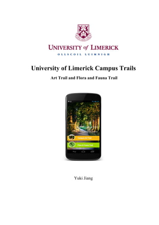
  • 35.   3.5.2 Paper Prototyping                                            Figure  15:  Information  for  North  Bank  Trail  and  for  Art  Trail         Figure  16:    Information  for  South  Bank  Trail                                                                                                                                                                                                                                                                                                                    37                                                            
  • 36.                                                                 Figure  17:  Paper  prototype  screen1  and  screen2         The   home   screen   displays   the   information   of   University   of   Limerick   logo   and   the   campus   trails   logo.   This   enables   the   user   to   understand   the   function   of   this   mobile   application.   The   second   screen   displays   the   information   of   the   campus   trails   consisting  of  two  kinds  of  trails:  the  Campus  Art  Trail  and  Flora  &  Fauna  Trail;  this   enable  the  user  to  have  a  brief  idea  of  the  information  behind  these  two  trails.                                                                                 Figure  18:  Paper  prototype  screen3  and  screen4         36  
  • 37.   When   the   user   clicks   into   the   art   trail,   the   following   screen   displays   a   brief   and   useful   information   about   the   number   of   stops,   the   approximate   time   and   the   distance   in   this   trail.   The   category   view   of   the   trail   allows   the   user   to   pick   a   starting   point,   which   is   suitable   for   them.   The   navigation   back   button   brings   the   user   back   to   the   last   screen   if   the   user   wants   to   switch   to   another   campus   trail   routine.                                                                                             Figure  19:  Paper  prototype  screen5  and  screen6       When   the   user   clicks   into   each   detailed   (POI),   the   four   buttons   below   the   POI’s   image/icon  allow  the  user  to  locate  current  location  and  find  the  direction  to  the   next   POI,   share   their   personal   views   and   comments   of   a   certain   sculpture   or   art   collections,   and   also   clicking   “like”   button   will   directly   connect   to   the   Campus   Trails   Facebook   Page.   The   more   information   button   is   mainly   designed   for   some   POIs   which   have   more   information   to   show   to   the   user,   for   example,   the   Bourn   Vincent  Gallery  has  a  dedicated  web  page  to  show  the  public  visitors  the  up  coming   event,  this  button  can  bring  the  user  to  the  link:  the  information  of  current  show  .             37  
  • 38.   3.5.3 User Test and Improvement                                        Figure  20:  User  Testing1  and  User  Testing2                                                                       All   the   participants   were   involved   in   the   user   test.   Several   typical   tasks   were   measured   and   all   the   errors   they   made   are   observed   and   written   on   the   notes.   Several   questions   were   asked   after   testing.   The   existing   problems   and   suggestions   are  listed  below:     • The  font  size  is  a  little  bit  small:  it  is  different  for  users  to  pick  a  starting  point   and  press  the  buttons.     • The  map  view  is  not  clear  enough  for  users  to  find  the  location.       • The   Tree   Trail   was   put   in   one   of   the   Flora   and   Fauna   Trails,   and   is   not   easy   for   users  to  find.     • The  prototype  is  the  Samsung  Galaxy  Nexus;  one  user  was  confused  about  the   back  button  on  the  navigation  bar.       38  
  • 39.   • The  distance  needs  to  change  from  miles  to  kilometers,  it  is  easier  for  user  to   understand  the  distance.         3.6  User  Interface  Design   3.6.1 UI Design Idea The  Interface  is  mainly  designed  with  two  colours:  orange  and  green,  representing   Art   Trail   and   Flora   and   Fauna   Trail,   these   two   colours   are   very   easy   to   be   recognized  and  the  font  can  stand  out  from  the  background  colour.  White  is  used   for  the  titles  of  each  POI;  dark  grey  is  used  for  the  titles  to  describe  each  POI;  the   size  of  the  font  and  buttons  were  tested  and  suitable  for  the  size  of  the  user’s  finger.   All  the  interfaces  are  designed  in  Photoshop  and  Illustrator.  Most  of  the  photos  in   this   application   were   provided   by   University   of   Limerick   Arts   Office,   several   of   the   photos   were   downloaded   from   http://www.all-­‐free-­‐download.com.   It   allows   public   to   copy,   modify,   distribute   and   perform   the   work,   even   for   commercial   purposes,  all  without  asking  permission.  The  rest  of  photos  were  taken  by  me.       Figure  21:  Art  Trail  Screens     39