Southern Forests for the Future
•Als PPTX, PDF herunterladen•
2 gefällt mir•1,250 views

WRI’s Southern Forests for the Future project seeks to raise awareness of the threats facing the forests of the southern United States - VA, FL, NC, SC, TX, KY, LA, OK, AR, TN, GA, AL, MS - and lay the foundation for increasing the acreage that is conserved or managed in a sustainable manner. For more information and interactive online maps, visit http://www.seesouthernforests.org

Empfohlen
Empfohlen
Weitere ähnliche Inhalte
Andere mochten auch
Andere mochten auch (20)
Ähnlich wie Southern Forests for the Future
Ähnlich wie Southern Forests for the Future (20)
Mehr von World Resources Institute (WRI)
Mehr von World Resources Institute (WRI) (20)
Kürzlich hochgeladen
Kürzlich hochgeladen (20)
Southern Forests for the Future
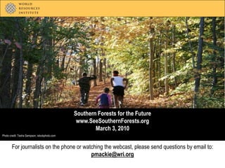
- 1. Southern Forests for the Future www.SeeSouthernForests.org March 3, 2010 Photo credit: Tesha Sampson, istockphoto.com For journalists on the phone or watching the webcast, please send questions by email to: pmackie@wri.org
- 2. Agenda Welcome and overview Janet Ranganathan Vice President for Science and Research World Resources Institute jranganathan@wri.org SeeSouthernForests.org and major findings Craig Hanson Director, People & Ecosystems Program World Resources Institute chanson@wri.org Role of private landowners Todd Gartner Manager of Conservation Incentives American Forest Foundation tgartner@forestfoundation.org For journalists on the phone or watching the webcast, please send questions by email to: pmackie@wri.org
- 3. Extent of southern U.S. forests
- 4. Chris Evans, River to River CWMA, Bugwood.org Leo Hohmann, Flickr Chris Evans, River to River CWMA, Bugwood.org
- 5. Southern forests are important for tackling climate change Source: U.S. Environmental Protection Agency (EPA) 2009.
- 6. Southern forests are important for freshwater Photo credit: Doug Bradley, Flickr
- 7. Southern forests are America’s “wood basket”
- 9. Southern forests face a number of challenges Photo credit: Yanik Chauvin, istockphoto.com
- 27. Source: Foreman and Wolke, 1992
- 28. Extent of southern U.S. forests
- 29. Pre-European settlement era (pre-1630)
- 30. Agricultural expansion era (1630-1880)
- 31. Industrial logging era (1880-1920)
- 33. Suburban encroachment era (1970-today)
- 34. Suburban expansion: Northeast Nashville, TN 1975
- 35. Suburban expansion: Northeast Nashville, TN 1990
- 36. Suburban expansion: Northeast Nashville, TN 2000
- 37. Suburban expansion: East Birmingham, AL 1990
- 38. Suburban expansion: East Birmingham, AL 2000
- 39. Suburban expansion: Northeast Atlanta, GA 1975
- 40. Suburban expansion: Northeast Atlanta, GA 1990
- 41. Suburban expansion: Northeast Atlanta, GA 2000
- 42. Urban and suburban area in South (1940)
- 43. Urban and suburban area in South (1970)
- 44. Urban and suburban area in South (2000)
- 45. Urban and suburban area in South (est. 2030)
- 46. Most southern forests are privately owned . . .
- 47. Most southern forests are privately owned . . . 100% = 214 million acres Public Individuals & families Companies Source: Smith, W. Brad, Patrick D. Miles, Charles H. Perry, and Scott A. Pugh. 2009. Forest Resources of the United States, 2007. Gen. Tech. Rep. WO-78. Washington, DC: U.S. Department of Agriculture, Forest Service; Butler, Brett J. 2008. Family forest owners of the United States, 2006. Gen. Tech. Rep. NRS-27. Newtown Square, PA: U.S. Department of Agriculture, Forest Service, Northern Research Station.
- 48. . . . and a generational shift is on the horizon 100% = 214 million acres Public < 55 years of age 24% Individuals & families Companies 55+ years of age 76% Age of individual & family forest owners Source: Smith, W. Brad, Patrick D. Miles, Charles H. Perry, and Scott A. Pugh. 2009. Forest Resources of the United States, 2007. Gen. Tech. Rep. WO-78. Washington, DC: U.S. Department of Agriculture, Forest Service; Butler, Brett J. 2008. Family forest owners of the United States, 2006. Gen. Tech. Rep. NRS-27. Newtown Square, PA: U.S. Department of Agriculture, Forest Service, Northern Research Station.
- 49. Future of southern forests rests in the hands of private landowners Photo credit: Margaret Munford, American Forest Foundation
- 50. AFF Vision AFF is committed to creating a future where North American forests are sustained by the public which understands and values the social, economic, and, environmental benefits they provide to our communities, our nation, and our world.
- 51. Keeping Private Forests as Forests Current Situation Slumping timber markets/ Mill closings Increasing development Tax pressures Majority private ownership/many landowners - Opportunity Inter-generational ownership changes Decreasing resource agency budgets Climate change
- 52. Who Owns the Forest?
- 53. Why Own Land? Beauty and scenery Family and heritage Privacy Nature protection Connected to home or cabin 10. Timber production National Woodland Owner Survey – US Forest Service
- 55. Legacy AgreementsKeeping the Forest in the Family
- 56. Remembering Aldo Leopold “When a farmer owns a rarity he should feel some obligation as its custodian, and a community should feel some obligation to help him carry the economic costs.” “Conservation will ultimately boil down to rewarding the private landowner who conserves the public interest.”
- 57. Ecosystem Services and Markets “On private land, we must...protect our forest landscapes before they no longer can function to support watershed health, biodiversity, conservation, and viable wood markets.” “Emerging markets….will provide landowners with expanded economic incentive to maintain and restore our forests” Secretary of Agriculture Vilsack 10/1/09
- 58. Markets for Ecosystem Services…Arrangements for placing economic value on natural assets normally “outside the market” Financial systems that enable people who produce products and services to be compensated by those who benefit
- 59. Recreation Riparian planting Carbon sequestration Tradeoffs Sustainable forestry Wetland restoration Species recovery Imagine… The portfolio approach to forest management – multiple incomestreams Conservation easement Source: Adapted from the Willamette Partnership
- 60. Sandhill Habitat Credit Trading Conserve existing high quality habitat in GA and AL Replicable habitat credit generating model Proactive/ Precompliance/ Voluntary offsets Broad partnership motivated to preclude listing Additional income streams for landowners
- 62. Acknowledgments Website Design Website Support Data providers
- 63. Questions? email pmackie@wri.org For more, visit www.SeeSouthernForests.org Photo credit: cwwycoff1, Flickr
Hinweis der Redaktion
- We’ve married the internet, satellite data, Flick-R, and social media to create SeeSouthernForests.org, an interactive Web site that layers a rich trove of environmental data and satellite images of southern U.S. forests; in other words, “all things southern forest” in one place for the first time. To do this, we built upon current satellite data utilizing Microsoft’s Bing maps and Google Earth, pieced together historical NASA satellite images over the past 30+ years, developed overlay maps of various forest features, unearthed rarely seen historical photos, and developed more than 80 case studies covering various features and trends in southern forests. Through this information portal, we aspire is to inform, inspire, and empower concerned citizens, forest owners, conservation organizations, government officials, companies, and others to ensure southern forests for the future. The system, located at SeeSouthernForests.org, highlights risks to these forests such as pest and pathogen outbreaks, active wildfires, potential climate change impacts, and forest conversion to suburban development – the leading cause of southern U.S. forest loss in recent decades. The system also maps other features such as the region’s protected areas and forest ownership. “SeeSouthernForests.org is a first-of-its-kind one-stop shop for map-based information about southern forests,” said Craig Hanson, director of WRI’s People & Ecosystems Program. “We have pulled together the power of GoogleEarth, Microsoft’s Bing Maps, NASA satellite images, ESRI technology, and a wide variety of forest data to raise awareness about the benefits of southern forests and the challenges they face.”
- WRI’s new online mapping system can help forest landowners in the South see the history of their forests through satellite images and better understand the forces of change affecting their properties. It also showcases examples of successful approaches for owners who want to retain their forests.
- Experts estimate that southern forests covered more than 350 million acres at the dawn of European settlement of the South in the early 1600s. Forest extent and composition had been primarily shaped by natural climate variations and lightning-induced fires, as well as by fires induced by Native Americans.
- For the next 2 ½ centuries, as European colonists gradually spread throughout the region, agriculture spread with them. Forests were cut for fuel wood and fences, but the biggest impact came from clearing and converting forests into fields. By 1880, agriculture had gradually reduced the region’s forest cover to 285 million acres.
- Although agricultural expansion continued after the Civil War and into the 20th century, by the late 1800s, large-scale timber extraction emerged as a complementary driver of change in southern forests. With diminishing supply from the Great Lakes region, industrial logging in the United States shifted south in the 1880s. Logging became the major driver of change for the next 40 years.Nearly 3 centuries after the dawn of European settlement, southern forest area declined to approximately 213 million acres by 1920.
- Between approximately 1920 and 1970, however, southern forests made a bit of a comeback in terms of extent. Four factors fueled this semi-regeneration era:First, farmers abandoned marginal cropland and pastures due to soil erosion, a financial crisis that hit agriculture in the 1920s, and the rise of urban jobs.Second, the region started adopting electricity and transportation fuels that were not wood based.Third, private sector investment in forest management increased with forest product companies replanting forests.Fourth, the U.S. government started to strengthen forest resource management through creating national forests, establishing parks and protected areas, and offering incentives to spur forest recovery such as the “Soil Bank Program.”By the early 1960s, forest area had climbed up to 228 million acres.
- Starting in the 1970s, however, the growth of urban and suburban areas began to play an increasingly prominent role. The pace of forest conversion to suburbs began to accelerate. By 2007, forest acreage fell once again to approximately 214 million acres.This era is somewhat different than previous eras due to its implications for forests. As we saw in the past, forests converted to farmland or cut for timber could become forest once again. However, unlike corn and cotton, houses and highways are permanent crops.
- Quite different from ownership structure of U.S. forests taken as a whole. individual and familes: 38% government: 43%
- Quite different from ownership structure of U.S. forests taken as a whole. individual and familes: 38% government: 43%
- We’ve married the internet, satellite data, Flick-R, and social media to create SeeSouthernForests.org, an interactive Web site that layers a rich trove of environmental data and satellite images of southern U.S. forests; in other words, “all things southern forest” in one place for the first time. To do this, we built upon current satellite data utilizing Microsoft’s Bing maps and Google Earth, pieced together historical NASA satellite images over the past 30+ years, developed overlay maps of various forest features, unearthed rarely seen historical photos, and developed more than 80 case studies covering various features and trends in southern forests. Through this information portal, we aspire is to inform, inspire, and empower concerned citizens, forest owners, conservation organizations, government officials, companies, and others to ensure southern forests for the future.