SlideShare ist ein Scribd-Unternehmen logo
1 von 4
CreatedBy:V. fernandez-Rogers2015
Chase Johnson2015
SRTM withgridlookslike this
Problem:Rastersare grouped byvaluesandnot individual raster.
Solution- Create gridthat overlaysthe individual raster.
(Iwill nottell youhowwe createdthe grid because itiswrongand we couldnot figure outhow to make it correctly.
Insteadwe solvedthe probleminaroundaboutway.)
Problem:Gridlinesnotcenteredontopof SRTM Raster.
Solution:Create centroids,Create Thiessenpolygon
Procedure for creating centroidpoints
In the map document, open the attribute table for the polygon feature class.
In the attribute table,navigate toTable Options> AddFieldandadd two new fieldsof type Double.Name one 'Latitude'
and the other 'Longitude'.
Right-click the Longitude field and select Calculate Geometry.
In the Calculate Geometry dialog box, select 'X Coordinate of Centroid' from the Property drop-down menu. Click OK.
Right-click the Latitude field and select Calculate Geometry.
In the Calculate Geometrydialogbox,select'YCoordinate of Centroid'fromthe Propertydrop-downmenu.ClickOK.
Exportto a table.
A. In the attribute table,selectTable Options>Export.
B. Specifyaname and locationforthe newtable.
Make an XY Eventlayer.
A. Navigate toArcToolbox >Data ManagementTools> Layersand Table Views>Make XY EventLayer.
B. Addthe newtable (fromstep7) as the XY Table.
C. For the X Field,selectthe Longitude field.
D. For the Y Field,selectthe Latitude field.
E. Name the neweventlayer.
F. Selectthe spatial reference orcoordinate system.
G. ClickOK.
(Optional) Exportthe EventLayerto a shapefile byright-clickingthe layerandnavigatingtoData> ExportData
Create ThiessenPolygon
OpenArctoolbox ---AnalysisTools--- Proximity—Create ThiessenPolygons
CentroidPoints1 (2)

Weitere ähnliche Inhalte

Andere mochten auch

Andere mochten auch (14)

Tra (ppt)
Tra (ppt)Tra (ppt)
Tra (ppt)
 
cansión te diran
cansión te dirancansión te diran
cansión te diran
 
CV OF L.K.WIJERATNE
CV OF L.K.WIJERATNECV OF L.K.WIJERATNE
CV OF L.K.WIJERATNE
 
Web 2
Web 2Web 2
Web 2
 
Thefamily
ThefamilyThefamily
Thefamily
 
Bronconeumonia y neumonia
Bronconeumonia y neumoniaBronconeumonia y neumonia
Bronconeumonia y neumonia
 
Jarvis Digital - June 2016
Jarvis Digital - June 2016Jarvis Digital - June 2016
Jarvis Digital - June 2016
 
presentation on time management
presentation on time managementpresentation on time management
presentation on time management
 
GPS and SRTM Accuracy
GPS and SRTM AccuracyGPS and SRTM Accuracy
GPS and SRTM Accuracy
 
Johnandchihuareport 160519123905
Johnandchihuareport 160519123905Johnandchihuareport 160519123905
Johnandchihuareport 160519123905
 
Extern conference - จิดาภา ตระกูลรังสิ
Extern conference - จิดาภา ตระกูลรังสิExtern conference - จิดาภา ตระกูลรังสิ
Extern conference - จิดาภา ตระกูลรังสิ
 
Tarea 3 actividades ii kenny briones
Tarea 3 actividades ii kenny brionesTarea 3 actividades ii kenny briones
Tarea 3 actividades ii kenny briones
 
Familia
FamiliaFamilia
Familia
 
FinalDraft dissertation
FinalDraft dissertationFinalDraft dissertation
FinalDraft dissertation
 

Ähnlich wie CentroidPoints1 (2)

Fluid Mechanics Project Assignment (Total 15)  Due Dates  .docx
Fluid Mechanics Project Assignment (Total 15)  Due Dates  .docxFluid Mechanics Project Assignment (Total 15)  Due Dates  .docx
Fluid Mechanics Project Assignment (Total 15)  Due Dates  .docxbryanwest16882
 
ENVI Pocket Guide: Volume 2 | Intermediate
ENVI Pocket Guide: Volume 2 | IntermediateENVI Pocket Guide: Volume 2 | Intermediate
ENVI Pocket Guide: Volume 2 | IntermediateAugustus Wright
 
georeferencing-200423175822.pdf
georeferencing-200423175822.pdfgeoreferencing-200423175822.pdf
georeferencing-200423175822.pdfrofevo9154
 
Georeferencing Image
Georeferencing ImageGeoreferencing Image
Georeferencing ImageSimran Vats
 
Dwm l ab_manual_final
Dwm l ab_manual_finalDwm l ab_manual_final
Dwm l ab_manual_finalVarsha Patil
 
Manual gis
Manual gisManual gis
Manual gissaha232
 
Solar Lighting in Ecotect
Solar Lighting in EcotectSolar Lighting in Ecotect
Solar Lighting in EcotectNYCCTfab
 

Ähnlich wie CentroidPoints1 (2) (11)

Fluid Mechanics Project Assignment (Total 15)  Due Dates  .docx
Fluid Mechanics Project Assignment (Total 15)  Due Dates  .docxFluid Mechanics Project Assignment (Total 15)  Due Dates  .docx
Fluid Mechanics Project Assignment (Total 15)  Due Dates  .docx
 
ERDAS_1.pdf
ERDAS_1.pdfERDAS_1.pdf
ERDAS_1.pdf
 
ENVI Pocket Guide: Volume 2 | Intermediate
ENVI Pocket Guide: Volume 2 | IntermediateENVI Pocket Guide: Volume 2 | Intermediate
ENVI Pocket Guide: Volume 2 | Intermediate
 
Ansys tutorial1
Ansys tutorial1Ansys tutorial1
Ansys tutorial1
 
georeferencing-200423175822.pdf
georeferencing-200423175822.pdfgeoreferencing-200423175822.pdf
georeferencing-200423175822.pdf
 
Georeferencing Image
Georeferencing ImageGeoreferencing Image
Georeferencing Image
 
Dwm l ab_manual_final
Dwm l ab_manual_finalDwm l ab_manual_final
Dwm l ab_manual_final
 
Axis vm stepbystep
Axis vm stepbystepAxis vm stepbystep
Axis vm stepbystep
 
Manual gis
Manual gisManual gis
Manual gis
 
Petrlel F 2 seismic display 2018 v1.1
Petrlel F 2 seismic display 2018 v1.1Petrlel F 2 seismic display 2018 v1.1
Petrlel F 2 seismic display 2018 v1.1
 
Solar Lighting in Ecotect
Solar Lighting in EcotectSolar Lighting in Ecotect
Solar Lighting in Ecotect
 

CentroidPoints1 (2)

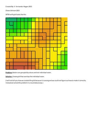
  • 1. CreatedBy:V. fernandez-Rogers2015 Chase Johnson2015 SRTM withgridlookslike this Problem:Rastersare grouped byvaluesandnot individual raster. Solution- Create gridthat overlaysthe individual raster. (Iwill nottell youhowwe createdthe grid because itiswrongand we couldnot figure outhow to make it correctly. Insteadwe solvedthe probleminaroundaboutway.)
  • 2. Problem:Gridlinesnotcenteredontopof SRTM Raster. Solution:Create centroids,Create Thiessenpolygon Procedure for creating centroidpoints In the map document, open the attribute table for the polygon feature class. In the attribute table,navigate toTable Options> AddFieldandadd two new fieldsof type Double.Name one 'Latitude' and the other 'Longitude'. Right-click the Longitude field and select Calculate Geometry. In the Calculate Geometry dialog box, select 'X Coordinate of Centroid' from the Property drop-down menu. Click OK. Right-click the Latitude field and select Calculate Geometry. In the Calculate Geometrydialogbox,select'YCoordinate of Centroid'fromthe Propertydrop-downmenu.ClickOK. Exportto a table. A. In the attribute table,selectTable Options>Export. B. Specifyaname and locationforthe newtable. Make an XY Eventlayer. A. Navigate toArcToolbox >Data ManagementTools> Layersand Table Views>Make XY EventLayer.
  • 3. B. Addthe newtable (fromstep7) as the XY Table. C. For the X Field,selectthe Longitude field. D. For the Y Field,selectthe Latitude field. E. Name the neweventlayer. F. Selectthe spatial reference orcoordinate system. G. ClickOK. (Optional) Exportthe EventLayerto a shapefile byright-clickingthe layerandnavigatingtoData> ExportData Create ThiessenPolygon OpenArctoolbox ---AnalysisTools--- Proximity—Create ThiessenPolygons