
Empfohlen
Weitere ähnliche Inhalte
Ähnlich wie THEORY OF IMAGE.pptx
Ähnlich wie THEORY OF IMAGE.pptx (16)
Kürzlich hochgeladen
Kürzlich hochgeladen (20)
THEORY OF IMAGE.pptx
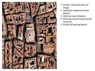
- 1. Center is the focal point of image. Individual settlement block pattern. Informal road networks. Planning around monumental structure Cluster of housing blocks.
- 2. Properly planned city Linear settlement pattern. Variation according to the local characteristics. Proper connectivity. Formation of recreational zones. Densely populated area. Road network intersecting at right angle.
- 3. Planned Grid pattern Cluster of individual blocks. Easy accessibility for each block. Densely populated. High rise structure Symmetrical planning
- 4. Diagonal road networks. Densely populated area. Properly planned road networks. Congested area. Open spaces between the buildings. Champhered building edges.
- 5. • Scattered planning according to the terrain. • Sloping roof . • Island surrounded with water. • Connectivity is not proper
- 6. • No margins • Improper placements • No vehicular connectivity • Compact planning • Densely populated
- 7. • River town • Segregated by water • Colour pallette can be seen • buildings are in Harmony • Streetscape is properly defined
- 8. • Radial planning • Converging towards focal point • Nuclear layouts • Free flowing road networks • Individual cluster pattern.
- 9. • High rise structure • Metropolitian town • Group planning • Grid pattern • Open spaces between each cluster
- 10. • Densely populated area • Flat roof • Low storeyed buildings • Tall buildings reflecting power. • congested planning.
- 11. • Planning according to terrain • Highly densely populated. • Asymmetric pattern • Diverging from central core. • Road network are in circular pattern.
- 12. Nice sheet