
Empfohlen
Weitere ähnliche Inhalte
Empfohlen
Empfohlen (20)
3DMap
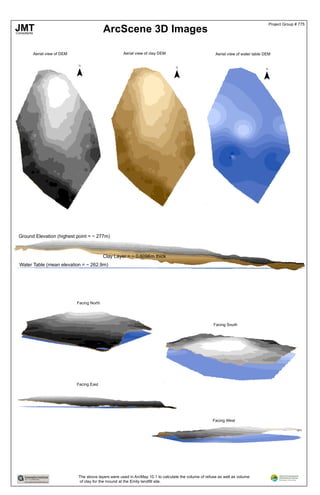
- 1. ArcScene 3D Images Aerial view of DEM Aerial view of clay DEM Aerial view of water table DEM ¯ ¯ ¯ Ground Elevation (highest point = ~ 277m) Clay Layer = ~ 0.6096m thick Water Table (mean elevation = ~ 262.9m) Facing North Facing South Facing West Facing East The above layers were used in ArcMap 10.1 to calculate the volume of refuse as well as volume of clay for the mound at the Emily landfill site. JMTConsultants Project Group # 775