Land Inspection Report
•
3 gefällt mir•3,015 views

This document provides a property inspection report for two parcels of land totaling 70,124.74 square meters located in San Rafael de Naranjo, Alajuela, Costa Rica. The report describes the legal ownership and permits for the properties, details their characteristics, locations, access, views, and surrounding infrastructure. It also provides comparable market data and appraises the total value of the properties at $701,301.40 based on a price of $10 per square meter. The report recommends the purchaser complete additional environmental studies to comply with regulations before developing the properties.

Empfohlen
Weitere ähnliche Inhalte
Was ist angesagt?
Was ist angesagt? (20)
Andere mochten auch
Andere mochten auch (20)
Ähnlich wie Land Inspection Report
Ähnlich wie Land Inspection Report (20)
Kürzlich hochgeladen
Kürzlich hochgeladen (20)
Land Inspection Report
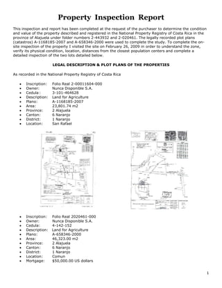
- 1. Property Inspection Report<br />This inspection and report has been completed at the request of the purchaser to determine the condition and value of the property described and registered in the National Property Registry of Costa Rica in the province of Alajuela under folder numbers 2-443932 and 2-020461. The legally recorded plot plans (catastros) A-1168185-2007 and A-658346-2000 were used to complete the study. To complete the on-site inspection of the property I visited the site on February 26, 2009 in order to understand the zone, verify its physical condition, location, distances from the closest population centers and complete a detailed inspection of the two lots detailed below.<br />LEGAL DESCRIPTION & PLOT PLANS OF THE PROPERTIES<br />As recorded in the National Property Registry of Costa Rica<br />Inscription:Folio Real 2-00011604-000 <br />Owner:Nunca Disponible S.A. <br />Cedula:3-101-464628<br />Description:Land for Agriculture<br />Plano:A-1168185-2007<br />Area:23,801.74 m2<br />Province:2 Alajuela<br />Canton:6 Naranjo<br />District:1 Naranjo<br />Location:San Rafael<br /> <br />Inscription:Folio Real 2020461-000<br />Owner: Nunca Disponible S.A.<br />Cedula:4-142-152<br />Description: Land for Agriculture<br />Plano: A-658346-2000<br />Area:46,323.00 m2<br />Province:2 Alajuela<br />Canton:6 Naranjo<br />District:1 Naranjo<br />Location:Comun<br />Mortgage:$50,000.00 US dollars<br />LOCATION<br />The properties referred to in this study are located in San Rafael de Naranjo and in the above map number 1 corresponds to the property location. The county map below, positions the location of the property in the community of San Rafael in relation to the closest population center of Naranjo.<br />Access to the properties is from a roughly leveled dirt right-of-way easement off an asphalt-covered public street.<br />Naranjo is located in the western sector of the Central Valley of Costa Rica and the present characteristics of this area are an agreeable climate with moderate precipitation and a median annual temperature above 21 degrees Celsius. The present state of the climate is dry during the months of December to April and the period of most precipitation is during the months of September thru November.<br />PUBLIC SERVICES<br />In the adjacent subdivision, all public services for urban living are available such as: Electricity, telephone lines, cable television, drinking water and streetlights. Furthermore, the streets are paved with curbs, gutters and underground sewers. Also, available nearby in the center of Naranjo are typical services such as shopping, sports and recreation centers, schools, medical clinics, gymnasiums, churches, boutiques, grocery stores, restaurants, gas stations, hardware stores, banks and other businesses and services.<br />CHARACTERISTICS OF THE PROPERTY<br />The properties inspected consist of two separate parcels of land presently zoned for agricultural use. Under consideration is the intention of the purchaser to construct 26 villas, a reception and restaurant building, a training and business center, a spa and workshop facilities, as well as parking, water feature and landscaping all inside a gated entrance. <br />Additional consideration is being given to the value of the raw land and its proximity to the existing public infrastructure as well as the adjacent subdivision that has lots with new roads, curbs, gutters, sewers, water lines and electricity.<br />Furthermore, the access right of way indicated on the plan is only four meters wide and yet during a meeting in the municipality of Naranjo, we were told that this easement (servidumbre de paso) is seven meters wide. A four meter wide access road is narrow when drainage, curb and gutters are included and this could limit the future development of the parcels of land that the public right of way services. <br />The obvious type of terrain that exists on the property is top soil, which is good for agriculture but not suitable for construction. Therefore, excavation of the construction sites will be necessary to install the foundations. In order to determine the amount of excavation, an environmental geological study will need to be completed to address land use as well as the impact of human activities on this property, (e.g., contamination by fertilizers and pesticides that may have been introduced into the soil by the current agricultural activity.) <br />The external boundaries of this property are easily identified from the adjacent land by posts, a border of trees and the river below. With respect to the topography, the top portion of the property maintains gradual sloping elevations, north to south, and ideal for construction. Along the eastern frontage, bordering the neighboring property that has been cut for individual lots is where the inspected property could be cut into building sites for cost-effective construction of the purchaser’s project. The western side of the property slopes down to the river frontage, offering natural privacy suitable for nature trails and other activities. The western slope of the property would be suitable for construction as well; however, the cost for the foundations would be greater than on the flatter terrain on the top portion of the property. <br />PERMITS<br />The property with 23,801.74m2 of land has been granted a use of land permit to subdivide under INVU, (Housing & Urban Development Institute) regulations, http://www.tramites.go.cr/manual/English/8/8-5.htm, which permit construction of dwellings on a minimum of 120 m2 of land, with frontage of 6 meters, 3 story maximum height and total density of 60 units per hectare with a maximum footprint of 70% of the land. The owner of the adjacent property with 46,323.00m2 of land has made application for the same land use commitment letter from the local municipal government. Based on its location directly adjacent, the same status of approval should be granted.<br />The following site plan details the housing construction and support structures that I recommend for this project. I created this plan from the developer’s description of the project he envisions and the land use commitment letter I obtained from the local municipal government. <br />MARKET VALUE<br />With reference to the valuation of this project, the primary considerations have been the adjacent land development project as well as other comparable properties with similar physical conditions and characteristics that are located in the vicinity of the inspected property.<br />The following comparable properties are described and numbered on the map below:<br />Inspected Property. Size 70,124.74 M2 <br />Lots 1000m2 @ $30.00m2, electric, water within 100 meters, gravel road, views<br />Two adjacent parcels to the inspected property. Size 66,297.77m2 @ $7.50m2, electric, water within 150 meters, minimal views, dirt access road.<br />Parcel 25 meters SE of property inspected. Size 39,543.50m2 @ $4.27m2, electric, water within 150 meters, minimal views, dirt access road. <br />Lots 50 meters SE of property inspected. Size 2679m2 @ $40.00m2.<br />Parcel of 30,000m2 @ $10.33m2., electric, water within 150 meters, views, gravel access road<br />Farm 208,349.22m2 @ $4.50m2., electric, water, paved to the property, views.<br />Lot 4245m2 @ $11.51m2, underground electric, water, phone line, paved to the lot, views.<br />Lots 1000m2 @ $30.00m2, electric, water within 100 meters, gravel road, views<br />Farm 764,700m2 @ $1.57m2., electric, water within 500 meters, gravel roads, views<br />Farm 129,925m2 @ $25.00m2, electric, water, paved to farm, views<br />Farm 35,000m2 @ $9.40m2, electric, water, paved to entrance, views<br />Farm 15,348m2 @ $11.00m2, electric, water within 200 meters, gravel access road, views<br />Lots from 5000m2 @ $35.00m2, Plantation Estates, gated, electric, water, gravel access roads views<br />Lots from 3000m2 @ $75.00m2, Hotel Vista del Valle, gated, underground electric, water, gravel access roads, views<br />ESTIMATE OF VALUE<br />In order to determine the value of the inspected property, the primary considerations were a combination of residential use factors. The major elements that influenced this estimate of the value of this land were the current values and availability of similar properties in the same area, with comparable sizes, terrain and with similar panoramic views. Utilizing the above formula, I offer the following realistic estimate of the raw land:<br />Property Number Size (m2) Value ($/m2) Total Value ($USA)<br />A-1168185-2007 23,801.74 $10.00 $238,017.40<br />A-658346-2000 46,323.00 $10.00 $463,230.00<br />TOTAL 70,124.74 $10.00 $701,301.40<br />CONCLUSIONS<br />Both properties contain suitable terrain for construction of the purchaser’s project and the privacy, views and unpolluted air are the principal attractions.<br />The owner stated that the lower property with 23,801.74m2 of land contains an aquifer of undetermined capacity which could limit the land use and cause denial of building permits.<br />Environmental studies need to be completed in order to comply with regulations imposed by the government institutions MINAET, http://www.minae.go.cr, SETENA, http://www.setena.go.cr, and INVU, http://www.invu.go.cr, AYA, http://www.aya.go.cr, Minister of Health, http://www.ministeriodesalud.go.cr<br />as well as the local Municipality, http://www.naranjo.go.cr . <br />Tom Rosenberger - www.costaricahomebuilder.com- 506-8364-1989<br />