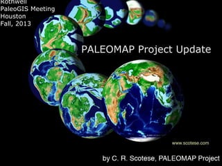
PALEOMAP Project Update by Christopher R. Scotese: 2013/Third Annual PaleoGIS & PaleoClimate Users Conference

The Rothwell Group, L.P.
The Rothwell Group, L.P.CEO um The Rothwell Group, L.P.
Rothwell
PaleoGIS Meeting
Houston
Fall, 2013

PALEOMAP Project Update
Thanks to PaleoAtlas Sponsors



















Shell 2002*
Anadarko 2003*
BHP 2003
ChevronTexaco 2003*
(KerrMcGee 2003)
Oxy 2003
Total 2003*
Petrobras 2004
Pioneer 2004
ExxonMobil 2004
Marathon 2004
BP 2005
StatOil (Hydro) 2005*
Woodside 2005
Newmont Mining 2005
ConocoPhillips 2006
Cobalt Int 2006
ENI 2007**

















(Devon 2006)
Vale 2008
Petronas 2008*
Apache 2010
Noble Energy 2011
Repsol 2012
HRT 2012
Mubadala (Pearl) 2012
RWE 2012
CEPSA 2012
KNOC 2013
Hess 2013
Maersk 2013
OMV 2013
*GANDOLPH sponsors
PALEOMAP Project 2013 Highlights
•

New Global Plate Model (Scotesev13a)
– Fixes “gaps”; High resolution ocean age polygons

•

Finalized PaleoAtlas Time Slices:
– One plate tectonic reconstruction for every stratigraphic stage (103 intervals)
– Additional paleogeographic maps for every Supersequence Boundary (SSB) & Maximum
Flooding Surface (MFS) (~140 total paleomaps)
– “PaleoAtlas Toolbar” for PaleoGIS (Rothwell Group)

•

Began work on Earth System Archive
– Define +50 ESA variables
– 4 new paleoclimate models (early Miocene, late Albian,Pennsylvanian, &mid Silurian)

•

Finalized Global Geology.com
– batch import & export tools

•
•

Publication of Boucot, Xu & Scotese (2013) by SEPM
Relocated back to Chicago (Evanston)
– To work on book “History of the Earth”; words to go with maps (documentation &
storytelling)
PALEOMAP Plans for 2014
•
•

•

Update & Populate Time Slices
Focus on Earth System Archive

– 4 additional paleoclimate simulations (total ~30)
– Build core of ESA with ‘GANDOLPH’ paleoclimate results
– Build user-friendly “backtracking “ tools

New Layers for PaleoAtlas
–
–
–
–
–
–

•
•
•

“Paleogeology” from Khain et al. atlases (~40 maps)
Lithofacies symbols & shading
Paleomagnetic poles & vectors
Hot Spots & LIPS
Geologic info from: Global Geology & PaleoBiology DB, COSUNA
Gridded raster versions of info from Earth System Archive

Resurrect Regional Plate Models

– SE Asia, Caribbean & GOM, W.Indian Ocean, Circum-Arctic, South Atlantic, & Neoproterozoic
(back to 1300 Ma)

Provide paleogeographic 1x1 grids for Rothwell’s Paleoclimate Software
Rough drafts of 20-25 Chapters of “History of the Earth” (~18 done)
PALEOMAP Project
Revised PALEOMAP Global Plate
Model

New Age of Ocean Floor Model
PALEOMAP Project Update by Christopher R. Scotese: 2013/Third Annual PaleoGIS & PaleoClimate Users Conference
PALEOMAP Project
PALEOMAP Project Update by Christopher R. Scotese: 2013/Third Annual PaleoGIS & PaleoClimate Users Conference
>100 PALEOMAP PaleoAtlas Time
Intervals (one for every geological
stage & major sequence boundary)
old #

•
•
•
•
•
•
•

new # of maps

Cenozoic 10
23
Cretaceous 8
24
Jurassic 6
13
Triassic 4
8
Late Paleozoic 12
Early Paleozoic 10
Precambrian 3

22
20
15
Paleogeology / Provenance
Khain, Ronov & Seslavinsky (1993)
Principal Feature Groups
• Graticule
• Modern Boundaries (rivers,lakes,cities,basins,high & low
•
•

resolution political boundaries)
Lithology (reefs, ophiolites, Boucot, PGAP, ODP)
Plate Tectonics (ancient plates, active plate boundaries,
motion vectors, labels, isochron, age of oceans, XOM Tectonic
Map**)

• PaleoRivers & Drainage (ArcGIS Hydrology Tool)
• PaleoClimate (Climate Zones, FOAM Results*)
• Paleogeography (Simple Pgeog, Hi-Res Pgeog, Highstand &
•
•

Lowstand shorelines, PaleoDEM,Sequence Stratigraphy – SSB,
MFS)
Geology (Geological Map of the World)
QuickMaps (14 different kinds of maps)
High Resolution Paleogeography

Aptian
120 Ma
Simple Paleogeography
Just Coastlines
Bas Relief
Geology
Climate Zones with Lithology
Paleoclimatic Reconstruction
Plate Tectonics
Time Intervals with Paleoclimate Simulations
GANDOLPH ESA
#
18
+ 12 = 30
Temperature
Rainfall
Winds
Salinity
Anoxia
Upwelling
PALEOMAP Project Update by Christopher R. Scotese: 2013/Third Annual PaleoGIS & PaleoClimate Users Conference
Simple
Data
Structure
Earth System Archive
Variables
• Type I

Descriptions/Measurements (17)
e.g. basin name/ PaleoDEM

• Type II

Global Geology (22)
e.g. Lithology, Formation Name

• Type III Paleoclimate (FOAM) (18)

e.g. Mean Annual Temperature)

• Type IV

Derivative (Composite) (infinite)
e.g. Carbonate Facies Probability
Earth System Archive:
Deliverables
Digital Data

2 Geologic “Data Cubes” of ESA variables
e.g. Mean Annual Temperature (MAT), Carbonate
Facies Probability (CFP), Carbonate/Clastic Ratio (CCR)

Cube (1) in paleoLat & paleoLong” to overlay
paleomaps
Cube (2) in modern Lat & Long for comparison
with unreconstructed data & maps

Software

“BackTracker” Program that creates bivariate plots
of ESA variables back through time.
“Back-Tracking”
Paleolatitude
 Elevation
 Mean Annual Temperature
 Precipitation
 & >30 other Earth System variables

PALEOMAP Project Update by Christopher R. Scotese: 2013/Third Annual PaleoGIS & PaleoClimate Users Conference
Earth System Archive
Variables
• Type I

Descriptions/Measurements (17)
e.g. basin name/ PaleoDEM

• Type II

Global Geology (22)
e.g. Lithology, Formation Name

• Type III Paleoclimate (FOAM) (18)

e.g. Mean Annual Temperature)

• Type IV

Derivative (Composite) (infinite)
e.g. Carbonate Facies Probability
Type I
Descriptions/Measurements
•
•
•
•
•
•
•
•
•
•
•
•
•

Map Age
•
Modern Latitude
•
Modern Longitude
•
Country
•
Geographic Region
Geodynamic Unit (Plate ID)
Paleolatitude
Paleolongitude
Elevation
PaleoDEM Identifier
Continentality
Oceanality (Restriction)
Distance from Coastline

Geological Outcrop
Basin Name
Depth to Basement
Age of Basement
Type II Global Geology
Geological Formation
Geological Comment
Approximate Thickness
Source: Outcrop/Well
Source of Data
Data Collected by
Depth from Surface
Sedimentary Lithology
Igneous/Metamorphic
Lithology
• Climate Indicators
• Accessory Rock Types
• Clastic/Carbonate
Ratio
•
•
•
•
•
•
•
•
•

• Terrestrial Depositional
Environment
• Marine/Transitional
Depositional Environment
• Sequence Stratigraphy
• Rock Unit above
• Rock Unit below
• Age of unconformity above
• Age of unconformity below
• Age Assignment Reliability
• Outcrop Image
• Stratigraphic Section Image
Type III Climate Model
•
•
•
•
•
•
•
•
•
•

Mean Annual Temperature
Sea Bottom Temperature
Mean Annual Precipitation
Runoff
Runoff to Ocean
Paleodrainage Basin
PaleoRIver
River Volume
Ice Thickness
Salinity

Summer/Winter Surface Currents
Sea Bottom Currents
Total Upwelling
Months of Upwelling
Summer/Winter Temperature
Summer/Winter Winds
Summer/Winter Rainfall
Summer/Winter Pressure
Type IV Derivative
•
•
•
•
•
•
•
•

Coarse Clastic Facies
Carbonate Facies
Evaporite Facies
Source Facies
Koeppen Zone
Vegetation Type
Ecozone
Paleosoil
PALEOMAP Project Update by Christopher R. Scotese: 2013/Third Annual PaleoGIS & PaleoClimate Users Conference
1 von 63

Más contenido relacionado

Was ist angesagt?(20)

Deep-Sea sediments-sunum.pptxDeep-Sea sediments-sunum.pptx
Deep-Sea sediments-sunum.pptx
İpek Olsun135 views
Introduction to seismic interpretationIntroduction to seismic interpretation
Introduction to seismic interpretation
Amir I. Abdelaziz6.4K views
Plate tectonic and paleomagnetismPlate tectonic and paleomagnetism
Plate tectonic and paleomagnetism
Umer Bhatti3.3K views
Bateman  mineral deposits - chapters 1 to 5Bateman  mineral deposits - chapters 1 to 5
Bateman mineral deposits - chapters 1 to 5
Ingenieria Minas6.4K views
Intro to petroleum geologyIntro to petroleum geology
Intro to petroleum geology
amrhaggag683 views
VolcanismVolcanism
Volcanism
myknolasco899 views
An Introduction to physical geology An Introduction to physical geology
An Introduction to physical geology
Tahsin Islam Ornee4.6K views
Continental driftContinental drift
Continental drift
Saba Jamal Din5.5K views
Continental drift theoryContinental drift theory
Continental drift theory
myknolasco12K views
Geology & geophysics in oil explorationGeology & geophysics in oil exploration
Geology & geophysics in oil exploration
Felipe Andrés33.8K views
Seminário Técnico-Ambiental da 12ª Rodada de Licitações - Bacia de Sergipe-Al...Seminário Técnico-Ambiental da 12ª Rodada de Licitações - Bacia de Sergipe-Al...
Seminário Técnico-Ambiental da 12ª Rodada de Licitações - Bacia de Sergipe-Al...
ANP - Agência Nacional do Petróleo, Gás Natural e Biocombustíveis2.5K views
Basics of seismic interpretationBasics of seismic interpretation
Basics of seismic interpretation
Amir I. Abdelaziz8.6K views
The earth and the moonThe earth and the moon
The earth and the moon
Michelle Jeffcoat3.8K views
Seismic Attributes .pptxSeismic Attributes .pptx
Seismic Attributes .pptx
Haseeb Ahmed19.7K views

Similar a PALEOMAP Project Update by Christopher R. Scotese: 2013/Third Annual PaleoGIS & PaleoClimate Users Conference

Similar a PALEOMAP Project Update by Christopher R. Scotese: 2013/Third Annual PaleoGIS & PaleoClimate Users Conference(20)

Más de The Rothwell Group, L.P.(13)

Último(20)

METHOD AND SYSTEM FOR PREDICTING OPTIMAL LOAD FOR WHICH THE YIELD IS MAXIMUM ...METHOD AND SYSTEM FOR PREDICTING OPTIMAL LOAD FOR WHICH THE YIELD IS MAXIMUM ...
METHOD AND SYSTEM FOR PREDICTING OPTIMAL LOAD FOR WHICH THE YIELD IS MAXIMUM ...
Prity Khastgir IPR Strategic India Patent Attorney Amplify Innovation22 views

PALEOMAP Project Update by Christopher R. Scotese: 2013/Third Annual PaleoGIS & PaleoClimate Users Conference

  • 2. Thanks to PaleoAtlas Sponsors                   Shell 2002* Anadarko 2003* BHP 2003 ChevronTexaco 2003* (KerrMcGee 2003) Oxy 2003 Total 2003* Petrobras 2004 Pioneer 2004 ExxonMobil 2004 Marathon 2004 BP 2005 StatOil (Hydro) 2005* Woodside 2005 Newmont Mining 2005 ConocoPhillips 2006 Cobalt Int 2006 ENI 2007**                (Devon 2006) Vale 2008 Petronas 2008* Apache 2010 Noble Energy 2011 Repsol 2012 HRT 2012 Mubadala (Pearl) 2012 RWE 2012 CEPSA 2012 KNOC 2013 Hess 2013 Maersk 2013 OMV 2013 *GANDOLPH sponsors
  • 3. PALEOMAP Project 2013 Highlights • New Global Plate Model (Scotesev13a) – Fixes “gaps”; High resolution ocean age polygons • Finalized PaleoAtlas Time Slices: – One plate tectonic reconstruction for every stratigraphic stage (103 intervals) – Additional paleogeographic maps for every Supersequence Boundary (SSB) & Maximum Flooding Surface (MFS) (~140 total paleomaps) – “PaleoAtlas Toolbar” for PaleoGIS (Rothwell Group) • Began work on Earth System Archive – Define +50 ESA variables – 4 new paleoclimate models (early Miocene, late Albian,Pennsylvanian, &mid Silurian) • Finalized Global Geology.com – batch import & export tools • • Publication of Boucot, Xu & Scotese (2013) by SEPM Relocated back to Chicago (Evanston) – To work on book “History of the Earth”; words to go with maps (documentation & storytelling)
  • 4. PALEOMAP Plans for 2014 • • • Update & Populate Time Slices Focus on Earth System Archive – 4 additional paleoclimate simulations (total ~30) – Build core of ESA with ‘GANDOLPH’ paleoclimate results – Build user-friendly “backtracking “ tools New Layers for PaleoAtlas – – – – – – • • • “Paleogeology” from Khain et al. atlases (~40 maps) Lithofacies symbols & shading Paleomagnetic poles & vectors Hot Spots & LIPS Geologic info from: Global Geology & PaleoBiology DB, COSUNA Gridded raster versions of info from Earth System Archive Resurrect Regional Plate Models – SE Asia, Caribbean & GOM, W.Indian Ocean, Circum-Arctic, South Atlantic, & Neoproterozoic (back to 1300 Ma) Provide paleogeographic 1x1 grids for Rothwell’s Paleoclimate Software Rough drafts of 20-25 Chapters of “History of the Earth” (~18 done)
  • 6. Revised PALEOMAP Global Plate Model New Age of Ocean Floor Model
  • 16. >100 PALEOMAP PaleoAtlas Time Intervals (one for every geological stage & major sequence boundary) old # • • • • • • • new # of maps Cenozoic 10 23 Cretaceous 8 24 Jurassic 6 13 Triassic 4 8 Late Paleozoic 12 Early Paleozoic 10 Precambrian 3 22 20 15
  • 18. Khain, Ronov & Seslavinsky (1993)
  • 19. Principal Feature Groups • Graticule • Modern Boundaries (rivers,lakes,cities,basins,high & low • • resolution political boundaries) Lithology (reefs, ophiolites, Boucot, PGAP, ODP) Plate Tectonics (ancient plates, active plate boundaries, motion vectors, labels, isochron, age of oceans, XOM Tectonic Map**) • PaleoRivers & Drainage (ArcGIS Hydrology Tool) • PaleoClimate (Climate Zones, FOAM Results*) • Paleogeography (Simple Pgeog, Hi-Res Pgeog, Highstand & • • Lowstand shorelines, PaleoDEM,Sequence Stratigraphy – SSB, MFS) Geology (Geological Map of the World) QuickMaps (14 different kinds of maps)
  • 25. Climate Zones with Lithology
  • 28. Time Intervals with Paleoclimate Simulations GANDOLPH ESA # 18 + 12 = 30
  • 31. Winds
  • 39. Earth System Archive Variables • Type I Descriptions/Measurements (17) e.g. basin name/ PaleoDEM • Type II Global Geology (22) e.g. Lithology, Formation Name • Type III Paleoclimate (FOAM) (18) e.g. Mean Annual Temperature) • Type IV Derivative (Composite) (infinite) e.g. Carbonate Facies Probability
  • 40. Earth System Archive: Deliverables Digital Data 2 Geologic “Data Cubes” of ESA variables e.g. Mean Annual Temperature (MAT), Carbonate Facies Probability (CFP), Carbonate/Clastic Ratio (CCR) Cube (1) in paleoLat & paleoLong” to overlay paleomaps Cube (2) in modern Lat & Long for comparison with unreconstructed data & maps Software “BackTracker” Program that creates bivariate plots of ESA variables back through time.
  • 41. “Back-Tracking” Paleolatitude  Elevation  Mean Annual Temperature  Precipitation  & >30 other Earth System variables 
  • 44. Earth System Archive Variables • Type I Descriptions/Measurements (17) e.g. basin name/ PaleoDEM • Type II Global Geology (22) e.g. Lithology, Formation Name • Type III Paleoclimate (FOAM) (18) e.g. Mean Annual Temperature) • Type IV Derivative (Composite) (infinite) e.g. Carbonate Facies Probability
  • 45. Type I Descriptions/Measurements • • • • • • • • • • • • • Map Age • Modern Latitude • Modern Longitude • Country • Geographic Region Geodynamic Unit (Plate ID) Paleolatitude Paleolongitude Elevation PaleoDEM Identifier Continentality Oceanality (Restriction) Distance from Coastline Geological Outcrop Basin Name Depth to Basement Age of Basement
  • 46. Type II Global Geology Geological Formation Geological Comment Approximate Thickness Source: Outcrop/Well Source of Data Data Collected by Depth from Surface Sedimentary Lithology Igneous/Metamorphic Lithology • Climate Indicators • Accessory Rock Types • Clastic/Carbonate Ratio • • • • • • • • • • Terrestrial Depositional Environment • Marine/Transitional Depositional Environment • Sequence Stratigraphy • Rock Unit above • Rock Unit below • Age of unconformity above • Age of unconformity below • Age Assignment Reliability • Outcrop Image • Stratigraphic Section Image
  • 47. Type III Climate Model • • • • • • • • • • Mean Annual Temperature Sea Bottom Temperature Mean Annual Precipitation Runoff Runoff to Ocean Paleodrainage Basin PaleoRIver River Volume Ice Thickness Salinity Summer/Winter Surface Currents Sea Bottom Currents Total Upwelling Months of Upwelling Summer/Winter Temperature Summer/Winter Winds Summer/Winter Rainfall Summer/Winter Pressure
  • 48. Type IV Derivative • • • • • • • • Coarse Clastic Facies Carbonate Facies Evaporite Facies Source Facies Koeppen Zone Vegetation Type Ecozone Paleosoil