SlideShare ist ein Scribd-Unternehmen logo
1 von 109
Tahoe History QuestionTahoe History Question
 Name (T-M-S) the firstName (T-M-S) the first
California Overland trail partyCalifornia Overland trail party
that brought wagons over thethat brought wagons over the
Sierra Nevada? Year? RoutesSierra Nevada? Year? Routes
used during the break up ofused during the break up of
the main party at Donnerthe main party at Donner
Lake, the person who stayedLake, the person who stayed
the winter, and what is uniquethe winter, and what is unique
about the number of theabout the number of the
people who finished thepeople who finished the
journey, what happened to thejourney, what happened to the
men when they first reachedmen when they first reached
Sutter’s Fort, the year etc…Sutter’s Fort, the year etc…
.
T o
R e n o
T o
C a r s o n
C ity
8 98 9
8 9
2 8
2 8
4 3 1
5 0
2 0 7
L a k e T a h o e
You realizeYou realize
that fourthat four
wheel drivewheel drive
does notdoes not
mean fourmean four
wheel stop.wheel stop.
You know you’reYou know you’re
a Tahoe Local if:a Tahoe Local if:
you thought ityou thought it
waswas
absolutelyabsolutely
appropriate toappropriate to
wear flipwear flip
flops, shortsflops, shorts
and a downand a down
parka in theparka in the
morning andmorning and
snow boots insnow boots in
the evening.the evening.
You know you’reYou know you’re
a Tahoe Local if:a Tahoe Local if:
In Week #2 We LearnedIn Week #2 We Learned
 United States History prior toUnited States History prior to
18441844
 Emigrant Trail beginningsEmigrant Trail beginnings
 John C. Fremont – 1844John C. Fremont – 1844
 Townsend-Murphy-StevensTownsend-Murphy-Stevens
Party 1844Party 1844
 Donner Party 1846 - 1847Donner Party 1846 - 1847
 California Gold Rush 1849.California Gold Rush 1849.
 Calif. boundary and Tahoe Gold.Calif. boundary and Tahoe Gold.
 This week #3, we will learnThis week #3, we will learn
aboutabout
 Overland Trail, 40 mile desertOverland Trail, 40 mile desert
 Settlers Arrive at Lake TahoeSettlers Arrive at Lake Tahoe
 The Lust for Silver –Virginia CityThe Lust for Silver –Virginia City
 The Cost of MiningThe Cost of Mining
Highway 50 Wagon Train From CarsonHighway 50 Wagon Train From Carson
City to Sacramento in Early JuneCity to Sacramento in Early June
Tahoe Wagon FreighterTahoe Wagon Freighter
Tahoe Settlers and the OverlandTahoe Settlers and the Overland
Trail to CaliforniaTrail to California
 The trail to California had been established by fur trappingThe trail to California had been established by fur trapping
mountain men and later members of the "Emigrantmountain men and later members of the "Emigrant
Societies" formed in the 1840's.Societies" formed in the 1840's.
 The efforts had established a passable wagon road toThe efforts had established a passable wagon road to
California over the four main obstacles:California over the four main obstacles:
 Through the Rocky Mts.,Through the Rocky Mts.,
 Around the Great Salt Lake Desert in Utah,Around the Great Salt Lake Desert in Utah,
 Across the Forty-mile desert in NevadaAcross the Forty-mile desert in Nevada
 Up and over the Sierra Nevada’s. The result was a journey ofUp and over the Sierra Nevada’s. The result was a journey of
2,000 miles in a single summer and fall, by oxen or horses2,000 miles in a single summer and fall, by oxen or horses
averaging 15 miles a day, which meant a voyage of aboutaveraging 15 miles a day, which meant a voyage of about
five months.five months. http://members.aol.com/DanMRosen/donner/westward.htmhttp://members.aol.com/DanMRosen/donner/westward.htm
 Between 1849 to 1859 20,000 (estimate) over landBetween 1849 to 1859 20,000 (estimate) over land
emigrants died– an average of 10 graves per mile.emigrants died– an average of 10 graves per mile. Meldahal,Meldahal, HardHard
Road WestRoad West University of Chicago Press 2008 pg 14University of Chicago Press 2008 pg 14
United States Expansion Started withUnited States Expansion Started with
Trading PostsTrading Posts
 Early 1800’s, trading posts were built forEarly 1800’s, trading posts were built for
commercial reasons, not military.commercial reasons, not military.
 Many trading posts used by Native AmericansMany trading posts used by Native Americans
were licensed by the federal government andwere licensed by the federal government and
called “factories”.called “factories”.
 Tribes conceded substantial territory to theTribes conceded substantial territory to the
United States ($1000 for protection) and toUnited States ($1000 for protection) and to
have access the "factories" at Fort Clark. Inhave access the "factories" at Fort Clark. In
1808 Treaty of Fort Clark1808 Treaty of Fort Clark in which the Osagein which the Osage
Indian Nation conceded most of Missouri.Indian Nation conceded most of Missouri.
 United States purchased Louisiana in 1803 fromUnited States purchased Louisiana in 1803 from
France but still had to make treaties with theFrance but still had to make treaties with the
local tribes.local tribes.
Trading PostsTrading Posts
 St. Louis, Missouri, on the West side ofSt. Louis, Missouri, on the West side of
the Mississippi/Missouri River confluence,the Mississippi/Missouri River confluence,
was a trading post and flourished into thewas a trading post and flourished into the
fur trading capital.fur trading capital.
 1843 privately owned Fort Bridger1843 privately owned Fort Bridger
Trading Post was built for the settlers andTrading Post was built for the settlers and
pioneers as they traveled the overlandpioneers as they traveled the overland
trail.trail.
Trading PostsTrading Posts
 Early traveler notesEarly traveler notes, “This fort is owned, “This fort is owned
by Bridger and Basquez. [sic] It is builtby Bridger and Basquez. [sic] It is built
of poles and dogwood mud. It is aof poles and dogwood mud. It is a
shabby concern.”shabby concern.”
http://www.wyomingtalesandtrails.com/bridger.htmlhttp://www.wyomingtalesandtrails.com/bridger.html
 Many times the trading post wereMany times the trading post were
broken down cabins. To the travelersbroken down cabins. To the travelers
it was a welcome sight for repairingit was a welcome sight for repairing
wagons, getting a hot meal and tradingwagons, getting a hot meal and trading
for fresh livestock.for fresh livestock.
Fort Bridger 1849
Before Emigrants Crossed the ContinentBefore Emigrants Crossed the Continent
 1804 Lewis and Clark spent five months at1804 Lewis and Clark spent five months at
Fort Mandan, North Dakota obtainingFort Mandan, North Dakota obtaining
information from Indians and French-Canadianinformation from Indians and French-Canadian
traders. A French-Canadian trapper namedtraders. A French-Canadian trapper named
Toussaint Charbonneau visited the captainsToussaint Charbonneau visited the captains
with his Shoshone wife, Sacagawea.with his Shoshone wife, Sacagawea.
 1807 Manuel Lisa Early organized the1807 Manuel Lisa Early organized the
mountain men into a large beaver fur tradingmountain men into a large beaver fur trading
companies. He built a chain of forts along thecompanies. He built a chain of forts along the
Missouri River.Missouri River.
 1812 John Jacob Astor set up forts in Oregon1812 John Jacob Astor set up forts in Oregon
for fur trading.for fur trading. http://www.isu.edu/~trinmich/Discoverers.htmlhttp://www.isu.edu/~trinmich/Discoverers.html
1812 Astor’s Pacific Fur Company1812 Astor’s Pacific Fur Company
Trading PostsTrading Posts (War of 1812 at the same time)(War of 1812 at the same time)
http://www.thefurtrapper.com/astorians.htm
The RendezvousThe Rendezvous
 1822 William Ashley sent his men out1822 William Ashley sent his men out
alone and made arrangements to meetalone and made arrangements to meet
them all at a centrally-located place a yearthem all at a centrally-located place a year
later and replenish his men.later and replenish his men.
 At that time a wild party they called "theAt that time a wild party they called "the
rendezvous." Every year throughout therendezvous." Every year throughout the
1820s and 30s it was the same: gambling,1820s and 30s it was the same: gambling,
drinking, storytelling that went on fordrinking, storytelling that went on for
days.days.
 By the late 1830s, beaver hats were goingBy the late 1830s, beaver hats were going
out of style and the silk hat were in style.out of style and the silk hat were in style.
The era of the Mountain Man had passedThe era of the Mountain Man had passed
and the age of the pioneer was beginning.and the age of the pioneer was beginning.
http://www.isu.edu/~trinmich/Discoverers.htmlhttp://www.isu.edu/~trinmich/Discoverers.html
1822 Ashley’s Rendezvous -1822 Ashley’s Rendezvous -
Jeremiah Johnson -1972 MovieJeremiah Johnson -1972 Movie
 Jeremiah (Redford) turnsJeremiah (Redford) turns
his back on civilization,his back on civilization,
circa 1827, and learnscirca 1827, and learns
the wilderness code ofthe wilderness code of
survival. Jeremiahsurvival. Jeremiah
eventually has an Indianeventually has an Indian
wife and adopts a son.wife and adopts a son.
 When Crow warriorsWhen Crow warriors
(Montana) kill his family,(Montana) kill his family,
he begins a one-manhe begins a one-man
revenge mission, gainingrevenge mission, gaining
legendary status as alegendary status as a
warrior.warrior.
 "In 1811, the overland party of Mr. Astor's"In 1811, the overland party of Mr. Astor's
expedition found the Indians so very troublesome inexpedition found the Indians so very troublesome in
the country of the Yellowstone River.the country of the Yellowstone River.
 June, 1812, considering it dangerous to pass againJune, 1812, considering it dangerous to pass again
by the Yellowstone River route of 1811, turnedby the Yellowstone River route of 1811, turned
toward the southeast and, after several days'toward the southeast and, after several days'
journey, came through the 7000 foot 'South Pass' injourney, came through the 7000 foot 'South Pass' in
the month of November, 1812.the month of November, 1812.
 http://en.wikipedia.org/wiki/South_Passhttp://en.wikipedia.org/wiki/South_Pass
'South Pass' November, 1812.'South Pass' November, 1812.
 TheThe Sweetwater RiverSweetwater River is ais a
tributary of the North Plattetributary of the North Platte
River, approximately 150 miRiver, approximately 150 mi
long, in Wyoming. It rises in atlong, in Wyoming. It rises in at
the continental divide near Souththe continental divide near South
Pass.Pass.
http://www.pbs.org/weta/thewest/places/states/wyoming/wy_sweetwater.htmhttp://www.pbs.org/weta/thewest/places/states/wyoming/wy_sweetwater.htm
Why Move a Family Across theWhy Move a Family Across the
United States?United States?
 East Coast economic depressions in 1837East Coast economic depressions in 1837
and 1841. At the same time, easternand 1841. At the same time, eastern
churches formed missionary societies forchurches formed missionary societies for
Christianity to evangelize the West.Christianity to evangelize the West.
 The primary wagon was the “PrairieThe primary wagon was the “Prairie
Schooners” usually measured 4 feet wideSchooners” usually measured 4 feet wide
by 12 feet long.by 12 feet long.
http://www.americanwest.com/trails/pages/oretrail.htmhttp://www.americanwest.com/trails/pages/oretrail.htm
“Prairie
Schooner”
Prairie Schooner in Sutter FortPrairie Schooner in Sutter Fort
Early travelers to PacificEarly travelers to Pacific
 18271827 Jedediah Smith: first known American toJedediah Smith: first known American to
traverse California's rugged Sierra Nevadatraverse California's rugged Sierra Nevada
Mountains. From West to the East!Mountains. From West to the East!
 1828,1828, Peter Skene Ogden discovered thePeter Skene Ogden discovered the
Humboldt River. Canadian working for theHumboldt River. Canadian working for the
Hudson’s Bay Company Explored – UtahHudson’s Bay Company Explored – Utah
 18321832 Bonneville explored Oregon and Nevada’sBonneville explored Oregon and Nevada’s
Great Basin.Great Basin.
 1833:1833: Joseph Walker (Walker Lake - HawthornJoseph Walker (Walker Lake - Hawthorn
NV) led a group of 65 trappers from the GreenNV) led a group of 65 trappers from the Green
River to California and back, becoming the firstRiver to California and back, becoming the first
to use what was to become the California trialto use what was to become the California trial
along the Humboldt River.along the Humboldt River.
 http://ourworld.compuserve.com/homepages/trailofthe49ers/trail.htmhttp://ourworld.compuserve.com/homepages/trailofthe49ers/trail.htm
1810 Alexander
VonHumboldt, for
scientific exploration,
as one of the most
prominent figures in
Europe at the time.
With the exception
of Napoleon
Bonaparte,
Humboldt was the
most famous man in
Europe.
Early travelers to CaliforniaEarly travelers to California
 1833:1833: Bonneville suggested to Walker that he should take a partyBonneville suggested to Walker that he should take a party
of men to California. The beaver population declined in the Rockyof men to California. The beaver population declined in the Rocky
Mountains.Mountains.
 1841:1841: The Bartelson-Bidwell Party were the first emigrantsThe Bartelson-Bidwell Party were the first emigrants
through the South Pass and to take the trail to California. Theythrough the South Pass and to take the trail to California. They
abandoned their wagons just west of present day Wells, Nevadaabandoned their wagons just west of present day Wells, Nevada
(Hwy 80 near Utah border). Their party included the first white(Hwy 80 near Utah border). Their party included the first white
woman (Nancy Kelsey) and child to make the trip. Lead by Tomwoman (Nancy Kelsey) and child to make the trip. Lead by Tom
“Broken Hand” Fitzpatrick“Broken Hand” Fitzpatrick
 1843:1843: The Chiles-Walker Party became the first to take wagonsThe Chiles-Walker Party became the first to take wagons
across Nevada. South to Kern County then up the Central Valley.across Nevada. South to Kern County then up the Central Valley.
 18441844: February 14 Fremont wrote down the sighting of Lake: February 14 Fremont wrote down the sighting of Lake
Tahoe. Also in the party: Kit Carson and Tom “Broken HandTahoe. Also in the party: Kit Carson and Tom “Broken Hand
Fitzpatrick. No wagons over the summitFitzpatrick. No wagons over the summit
 1844:1844: November 16, 1844November 16, 1844 The Stevens Townsend Murphy PartyThe Stevens Townsend Murphy Party
became the first non military group to take wagons across thebecame the first non military group to take wagons across the
Sierras.Sierras.

1846:1846: Mormon BattalionMormon Battalion 1846:1846: The Donner partyThe Donner party
http://ourworld.compuserve.com/homepages/trailofthe49ers/trail.htmhttp://ourworld.compuserve.com/homepages/trailofthe49ers/trail.htm
Jedediah Smith 1827Jedediah Smith 1827
18331833 Joseph WalkerJoseph Walker
1833, Bonneville suggested to Walker that he1833, Bonneville suggested to Walker that he
should take a party of men to California. The beavershould take a party of men to California. The beaver
population declined in the Rocky Mountains.population declined in the Rocky Mountains.
Walker and his party of forty men, each man takingWalker and his party of forty men, each man taking
four horses.four horses.
One to ride and three to carry supplies. ThisOne to ride and three to carry supplies. This
included 60 pounds of dried meat per man.included 60 pounds of dried meat per man.
Walker decided to follow the Humboldt River intoWalker decided to follow the Humboldt River into
Nevada.Nevada.
18331833 Joseph WalkerJoseph Walker
 When they reached the Sierra Nevada, severalWhen they reached the Sierra Nevada, several
men argued that they should be allowed to gomen argued that they should be allowed to go
back.back.
 Walker continued and after killing and eatingWalker continued and after killing and eating
some of the horses, they came out of the Sierrasome of the horses, they came out of the Sierra
through the Yosemite Valley.through the Yosemite Valley.
 While in California, they experienced their firstWhile in California, they experienced their first
earthquake and viewed giant redwood trees.earthquake and viewed giant redwood trees.
 By November 1833 they saw the Pacific Ocean.By November 1833 they saw the Pacific Ocean.
They spent 3 months building up their strengthThey spent 3 months building up their strength
to return. Six of the party enjoyed California soto return. Six of the party enjoyed California so
much they stayed.much they stayed.
18331833 Joseph Walker LakeJoseph Walker Lake
 On Highway 95 between Reno andOn Highway 95 between Reno and
Las Vegas. Walker Lake is justLas Vegas. Walker Lake is just
north of Hawthorne, Nevada.north of Hawthorne, Nevada.
 Walker Lake is that it is one of onlyWalker Lake is that it is one of only
six freshwater (slightly salty)six freshwater (slightly salty)
terminal lakes in the world.terminal lakes in the world. PyramidPyramid
Lake and four lakes in Central AsiaLake and four lakes in Central Asia
being the othersbeing the others
 With over a century of upriverWith over a century of upriver
agricultural diversions, Walker Lakeagricultural diversions, Walker Lake
has lost over three fourths of itshas lost over three fourths of its
volume. The lake level has fallen byvolume. The lake level has fallen by
140 feet and the meandering shore140 feet and the meandering shore
line boundary has receded 25 milesline boundary has receded 25 miles
since 1906. Salt levels havesince 1906. Salt levels have
increased to a point which nowincreased to a point which now
threaten the trout fishery. Mono,threaten the trout fishery. Mono,
Pyramid, Great Salt Lake are salty.Pyramid, Great Salt Lake are salty.
Walker Lake
1843
1833
1841:1841: The Bartelson-Bidwell PartyThe Bartelson-Bidwell Party
 The Bidwell-Bartleson Party of 1841 was theThe Bidwell-Bartleson Party of 1841 was the
first organized group of non-commercial,first organized group of non-commercial,
non-military emigrants with a female andnon-military emigrants with a female and
child attempting to reach northern Californiachild attempting to reach northern California
by way of the Humboldt River.by way of the Humboldt River.
 Leaving the Oregon Trail abandoned theirLeaving the Oregon Trail abandoned their
wagons, reaching the Humboldt River andwagons, reaching the Humboldt River and
following the Humboldt River to its sink.following the Humboldt River to its sink.
 The party crossed the Sierra Nevada withoutThe party crossed the Sierra Nevada without
wagons by turning southwest, where theywagons by turning southwest, where they
struggled over the mountains near (Kelseystruggled over the mountains near (Kelsey
Mt) and the present Sonora Pass (seeing BigMt) and the present Sonora Pass (seeing Big
Trees) into the San Joaquin Valley.Trees) into the San Joaquin Valley.
http://www.emigranttrailswest.org/caltrail.htmhttp://www.emigranttrailswest.org/caltrail.htm
18 year old Nancy Roberts Kelsey18 year old Nancy Roberts Kelsey
 Was the first white woman (with baby MarthaWas the first white woman (with baby Martha
Ann on hip) to cross the Sierra Nevada with theAnn on hip) to cross the Sierra Nevada with the
Bartleson Bidwell Party 1841.Bartleson Bidwell Party 1841.
 Given credit for stitching the California Bear FlagGiven credit for stitching the California Bear Flag
in 1846. Designed by William Todd (Mary Toddin 1846. Designed by William Todd (Mary Todd
Lincoln’s nephew).Lincoln’s nephew).
 Husband Benjamin KELSEY, (1813-1889): m'dHusband Benjamin KELSEY, (1813-1889): m'd
1838: emigrated to CA 1841; made and lost1838: emigrated to CA 1841; made and lost
several fortunes; involved in moving cattle fromseveral fortunes; involved in moving cattle from
CA to BC; had sawmill near Sonoma; mined forCA to BC; had sawmill near Sonoma; mined for
gold in El Dorado County; helped establish thegold in El Dorado County; helped establish the
town oftown of KelseyvilleKelseyville (near Clear Lake) in CA;(near Clear Lake) in CA;
1843 traveled to OR with his family; 18441843 traveled to OR with his family; 1844
returned to CA.returned to CA. http://www.oregonpioneers.com/1841.htmhttp://www.oregonpioneers.com/1841.htm
"Where my husband"Where my husband
goes I can go. I cangoes I can go. I can
better stand thebetter stand the
hardships of the journeyhardships of the journey
than the anxieties for anthan the anxieties for an
absent husband.“absent husband.“
http://members.aol.com/DanMRosen/donner/westward.htmhttp://members.aol.com/DanMRosen/donner/westward.htm
Emigrant trail, Mormon Trail, PonyEmigrant trail, Mormon Trail, Pony
Express, Lincoln Highway, Highway 80Express, Lincoln Highway, Highway 80
Fremont 1843-1844 2Fremont 1843-1844 2ndnd
Expedition -Expedition -@@ TahoeTahoe
Fort HallFort Hall
St. Joseph MO
Walker’s Party 1833 Over the Sierra no wagonsWalker’s Party 1833 Over the Sierra no wagons
Fremont 1845-1846 3Fremont 1845-1846 3rdrd
Expedition. Bear Flag Revolt, Mexican War,Expedition. Bear Flag Revolt, Mexican War,
Donner PartyDonner Party
Oregon Trial 1843 Wagons to OregonOregon Trial 1843 Wagons to Oregon
1846 the Mormons / Donner Party1846 the Mormons / Donner Party
 In 1846 the Mormons were moving from Nauvoo, Ill toIn 1846 the Mormons were moving from Nauvoo, Ill to
Salt Lake City UT (by force.) Brigham Young requestedSalt Lake City UT (by force.) Brigham Young requested
President Polk to finance the movement westward.President Polk to finance the movement westward.
Polk did not directly pay for the move though he agreedPolk did not directly pay for the move though he agreed
to give wages for soldiers and the soldiers could giveto give wages for soldiers and the soldiers could give
the money to the church. The Mormons decided tothe money to the church. The Mormons decided to
provided 500 soldiers for development of the Santa Feprovided 500 soldiers for development of the Santa Fe
Trail for the US solders travel during to the MexicanTrail for the US solders travel during to the Mexican
War.War.
 Battalion members each received a $42 clothingBattalion members each received a $42 clothing
allowance, paid in advance, for their one-yearallowance, paid in advance, for their one-year
enlistment.enlistment.
 The bulk of this money was contributed to the ChurchThe bulk of this money was contributed to the Church
fund from which wagons, teams, and other necessitiesfund from which wagons, teams, and other necessities
for the larger exodus were purchased.for the larger exodus were purchased.
 Actual wages paid out came to nearly $30,000. Later,Actual wages paid out came to nearly $30,000. Later,
Battalion members returning from California, at JohnBattalion members returning from California, at John
Sutter's mill, contributed $17,000 in gold to the SaltSutter's mill, contributed $17,000 in gold to the Salt
Lake City settlement.Lake City settlement.
http://www.lds.org/library/pio_sto/Pioneer_Trail/12_Council_Bluffs.htmlhttp://www.lds.org/library/pio_sto/Pioneer_Trail/12_Council_Bluffs.html
The 1846 MormonsThe 1846 Mormons
 From 1846 to 1869 12,000 MormonsFrom 1846 to 1869 12,000 Mormons
moved from Nauvoo, Illinois to Saltmoved from Nauvoo, Illinois to Salt
Lake City along the same initial trail.Lake City along the same initial trail.
 February 1846 started the move toFebruary 1846 started the move to
Salt Lake setting up roads and foodSalt Lake setting up roads and food
supplies along the way for futuresupplies along the way for future
Church members.Church members.
1848 Mormons Heading1848 Mormons Heading EastEast OverOver
the Sierra Nevada using Carson Passthe Sierra Nevada using Carson Pass
 On July 3, 1848 the party started eastOn July 3, 1848 the party started east
clearing the road for wagon travel. (Eastclearing the road for wagon travel. (East
of Placerville off Highway 50)of Placerville off Highway 50)
 Kept 300 animals at a Park owned byKept 300 animals at a Park owned by
James Sly - now known as Sly Park.James Sly - now known as Sly Park.
 3 scouts killed near a spring - now known3 scouts killed near a spring - now known
as Tragedy Springs.as Tragedy Springs.
 Went over a pass that had a name carvedWent over a pass that had a name carved
in a tree “Carson” now Carson Pass.in a tree “Carson” now Carson Pass.
 Having hope that they could make it theyHaving hope that they could make it they
named it Hope Valley.named it Hope Valley.
 Followed the Carson River through CarsonFollowed the Carson River through Carson
Valley, 40 mile desert.Valley, 40 mile desert.
S.A Mitchells 1846 MapS.A Mitchells 1846 Map
San Diego
1847
Coloma
1848 Salt Lake City
1846
Nauvoo IA
1846
Mexican
War 1846
to 1848
Mormon Battalion
Discharged July 1847
250 travel North
Disbanded
Mormon Battalion
June 1848
Mormon Battalion
July 20, 1846
Leavenworth
Kansas
The Forty-Mile Desert -The Forty-Mile Desert -
40 miles to water40 miles to water
 Carson
City
Fallon 
 Current Highway 50
Carson River 40 mile Desert
Truckee River 40 mile Desert
**40 Mile desert Carson River route40 Mile desert Carson River route
 A footnote to the journal of Lorenzo Sawyer (1850)A footnote to the journal of Lorenzo Sawyer (1850)
by Edward Eberstadt stated that one emigrant onby Edward Eberstadt stated that one emigrant on
the Carson route countedthe Carson route counted
 1061 dead mules,1061 dead mules,
 4,960 dead horses, and4,960 dead horses, and
 3750 dead oxen and cows.3750 dead oxen and cows.
 Also noted were 963 graves andAlso noted were 963 graves and
 An estimate that probably 5000 persons perishedAn estimate that probably 5000 persons perished
during 1850.during 1850.
 John Wood (1850) wrote a vivid account of hisJohn Wood (1850) wrote a vivid account of his
sufferings on the desert and observed that somesufferings on the desert and observed that some
3000 wagons and 3 million dollars worth of property3000 wagons and 3 million dollars worth of property
lay abandoned on the Carson Route. Such was thelay abandoned on the Carson Route. Such was the
desert roll of Destruction Valley.desert roll of Destruction Valley. Everett W. HarrisEverett W. Harris TheThe
Emigrants Passed This WayEmigrants Passed This Way Western Trails Research Associates pg 90Western Trails Research Associates pg 90
Mark TwainMark Twain
Carson 1861Carson 1861
40 Mile Desert40 Mile Desert
Route and RagtownRoute and Ragtown
Mormon
Immigrant
Trail
HeadingHeading EastEast Over the SierraOver the Sierra
Nevada Mormon/Carson Pass RouteNevada Mormon/Carson Pass Route
 ““The most successful road opening in westernThe most successful road opening in western
history.”history.” www.emigranttrailswest.orgwww.emigranttrailswest.org
 From the Overland Trail cross roads, four branchFrom the Overland Trail cross roads, four branch
roads led to the Gold mines in California.roads led to the Gold mines in California.
 Initially emigrants were divided equally overInitially emigrants were divided equally over
those land routes, Beckworth (North), Hennessthose land routes, Beckworth (North), Henness
Pass, Donner (middle) and Mormon Carson PassPass, Donner (middle) and Mormon Carson Pass
(South). Just two years later, by 1850, 95(South). Just two years later, by 1850, 95
percent of the ensuing emigrants followed thepercent of the ensuing emigrants followed the
Mormon Carson Pass route south of Lake Tahoe.Mormon Carson Pass route south of Lake Tahoe.
 Mormon/Carson Pass 3 river crossingsMormon/Carson Pass 3 river crossings
Truckee/Donner Pass 23 river crossings.Truckee/Donner Pass 23 river crossings. Tahoe DailyTahoe Daily
Tribune Denise SloanTribune Denise Sloan How Local is a Local?How Local is a Local? Page 18 1998Page 18 1998
First European Tahoe Visitors-First European Tahoe Visitors-
Trans – Sierra passagesTrans – Sierra passages
 1850-1851 (1848 Landauer) Col. John Calhoun1850-1851 (1848 Landauer) Col. John Calhoun
“Cock-eye” Johnson visited Lake Valley over“Cock-eye” Johnson visited Lake Valley over
Echo summit. (No official journal entry) In 1853Echo summit. (No official journal entry) In 1853
Rubicon Gorge.Rubicon Gorge.
 Placerville lawyer, rancher, explorer, StatePlacerville lawyer, rancher, explorer, State
Assembly member and a major participant in ElAssembly member and a major participant in El
Dorado's only “Indian War.”Dorado's only “Indian War.”
 He allowed up to 800 militia to stay on his “SixHe allowed up to 800 militia to stay on his “Six
Mile” (east of Placerville) ranch.Mile” (east of Placerville) ranch.
 Johnson’s Pass (lower elevation than Carson’sJohnson’s Pass (lower elevation than Carson’s
pass) at the south end of Tahoe Valley in thepass) at the south end of Tahoe Valley in the
spring of 1850-51 (1848 Landauer) andspring of 1850-51 (1848 Landauer) and
followed the South fork of the American Riverfollowed the South fork of the American River
back to Placerville.back to Placerville.
Placerville 1851Placerville 1851
Johnson's PassJohnson's Pass
 The 1849 rush brought wagon trains across the HighThe 1849 rush brought wagon trains across the High
Sierra.Sierra.
 Most of the wagons moved south of Tahoe up WoodfordMost of the wagons moved south of Tahoe up Woodford
Canyon, through Hope Valley and over Kit Carson PassCanyon, through Hope Valley and over Kit Carson Pass
(Route of today's Highway 88). Carson Pass is high and(Route of today's Highway 88). Carson Pass is high and
winter created severe wind and snow problems.winter created severe wind and snow problems.
 Johnson's Pass was lower and less exposed to theJohnson's Pass was lower and less exposed to the
harsh weather mostly being protected by the Southharsh weather mostly being protected by the South
Fork of the American River canyon.Fork of the American River canyon.
 Its drawback was the sharp rise from the Lake Valley,Its drawback was the sharp rise from the Lake Valley,
but the determined pioneers still moved up Johnson'sbut the determined pioneers still moved up Johnson's
Hill (Echo Summit). Wagons were block and tackled upHill (Echo Summit). Wagons were block and tackled up
1,100 feet in a distance of three quarters of a mile. The1,100 feet in a distance of three quarters of a mile. The
rise was to a flat area called "Cape Horn." From therise was to a flat area called "Cape Horn." From the
Horn, the trail made two switch backs, then over theHorn, the trail made two switch backs, then over the
pass and down the South Fork of the American Riverpass and down the South Fork of the American River
canyon to Placerville.canyon to Placerville. http://www.americana-tahoe.com/Jimhttp://www.americana-tahoe.com/Jim
%20Hubbard/HWY%2050.html%20Hubbard/HWY%2050.html
Col. John Calhoun “Cock-Eye” JohnsonCol. John Calhoun “Cock-Eye” Johnson
 1850-51 (48) – the Johnson (Echo Summit) cut1850-51 (48) – the Johnson (Echo Summit) cut
off shortened the Mormon (Carson Pass) routeoff shortened the Mormon (Carson Pass) route
by several miles.by several miles. Laundaur pg 61Laundaur pg 61
 Going East, once in Lake Valley the trail turnedGoing East, once in Lake Valley the trail turned
south (over to what will be known as Luther'ssouth (over to what will be known as Luther's
Pass in 1854) to meet the Mormon EmigrantPass in 1854) to meet the Mormon Emigrant
Trail in Hope Valley.Trail in Hope Valley.
 1860 the pony express trail (initially went over1860 the pony express trail (initially went over
Luther's Pass) then changed to the shorter LakeLuther's Pass) then changed to the shorter Lake
Valley using Kingsbury Grade /Daggett’s Pass.Valley using Kingsbury Grade /Daggett’s Pass.
 Three years later the popular (shorter) trailThree years later the popular (shorter) trail
went over the top of Cave Rock over the Carsonwent over the top of Cave Rock over the Carson
Range down to Eagle Valley (Carson City).Range down to Eagle Valley (Carson City).
Lake
Tahoe
Hawley’s
Grade
Johnson’s
Cutoff
Meyers’s
Grade
Echo
Lakes
Echo
Summit
“Y”
Pickett’s
Junction
Old
Luther’s
Pass Road
North
Toward Lake Tahoe on
Luther’s Pass
Old Luther’s
Pass Road
Current Luther’s
Pass Road
Highway 89
Pickett’s
Junction
To
Kirkwood
Ski Resort
Highway
88/89
North
1855 (54) Asa Hawley1855 (54) Asa Hawley LandauerLandauer
 Built a graded road to the top of Echo Summit that ledBuilt a graded road to the top of Echo Summit that led
from his door step in Upper Lake Valley (Christmasfrom his door step in Upper Lake Valley (Christmas
Valley).Valley).
 Initially he was a way station operator in Elkhorn MillInitially he was a way station operator in Elkhorn Mill
east of Placerville.east of Placerville.
 ““Tahoe Natives would not let me fish the streams.”Tahoe Natives would not let me fish the streams.”
 First year round resident in the Tahoe Basin. (notFirst year round resident in the Tahoe Basin. (not
verifiable).verifiable).
 1856 or 1857 tried to measure Lake Tahoe’s1856 or 1857 tried to measure Lake Tahoe’s
circumference and locate an outlet, with James Greencircumference and locate an outlet, with James Green
and John A.Thompson, by counting a half mile distanceand John A.Thompson, by counting a half mile distance
by pace and timing how long it took to travel thatby pace and timing how long it took to travel that
distance with a row boat.distance with a row boat.
 Their conclusion was Lake Tahoe circumference 150Their conclusion was Lake Tahoe circumference 150
miles!! Actually 72 miles.miles!! Actually 72 miles.
 1870, moved to Kings Canyon, Carson City then to1870, moved to Kings Canyon, Carson City then to
Latrobe CA, died in Yerington NV 1899.Latrobe CA, died in Yerington NV 1899.
Kings Canyon
Road
Clear Creek
Canyon Road
Current
highway 50
Spooner
Summit
KingsCanyon
1863 Saga I pg 236
1860 Saga I pg 236
1851 (54)
E
V A D A
N
Tahoe 1850’s to 1860’sTahoe 1850’s to 1860’s
 Few structures, several trails marked,Few structures, several trails marked,
wagon and coaches and a few boats.wagon and coaches and a few boats.
 Few people spent the short summerFew people spent the short summer
haying, grazing cattle, operating wayhaying, grazing cattle, operating way
stations and saloons, livery stables andstations and saloons, livery stables and
trading posts.trading posts.
 Natives continue to follow their traditionalNatives continue to follow their traditional
ways of fishing hunting gathering food andways of fishing hunting gathering food and
materials for winter.materials for winter.
Old
Meyers
Grade
Echo
Summit
Echo
Lakes
Lake Valley (Christmas Valley)
To Sacramento
Johnson’s Cutoff 1850-51Johnson’s Cutoff 1850-51
Hawley’s Grade 1855(54)Hawley’s Grade 1855(54)
 Drive on South Upper Truckee untilDrive on South Upper Truckee until
you see this sign.you see this sign.
Views from Hawley’s GradeViews from Hawley’s Grade
Bottom of Old Meyers Grade -1857Bottom of Old Meyers Grade -1857
Top of Old Meyers Grade -Top of Old Meyers Grade -
Cape HornCape Horn
 This road still can beThis road still can be
used in emergenciesused in emergencies
Meyers grade
1942 -1949
Old Meyers Grade
1857
Johnson Cutoff
1850-51 (48)
To Echo Lakes
U n it e d S t a te s 1 8 5 4
N o rt h e rn F re e S ta t e s
S o u th e rn S la v e S ta te s
P o p u la r S o v e re ig n t y
F e d e ra l (U n io n ) Te rrit o rie s
K a n s a s
fre e /s la v e ?
N e b ra s k a
f re e / s la v e ?
1 8 4 6
M
isso u ri
M a in e
1 8 5 0
3 6 3 0 ” 3 6 3 0 ”
You know you’reYou know you’re
a Tahoe Local if:a Tahoe Local if:
You realizeYou realize
when youwhen you
change thechange the
studdedstudded
snow tires tosnow tires to
regular tiresregular tires
you canyou can
decrease thedecrease the
radioradio
volume.volume.
Last Hour We LearnedLast Hour We Learned
 Chapter 5 SettlersChapter 5 Settlers
Arrive at Lake TahoeArrive at Lake Tahoe
 This hour we willThis hour we will
learn aboutlearn about
 The Lust for SilverThe Lust for Silver
 Sutro: tunnelSutro: tunnel
 Diedesheimer: squareDiedesheimer: square
set miningset mining
 Hallidie: cableHallidie: cable
 The cost of miningThe cost of mining
Chapter 6 Lust for SilverChapter 6 Lust for Silver
 Silver StateSilver State
What Was Discovered in VirginiaWhat Was Discovered in Virginia
City in 1859?City in 1859?
 Gold and SilverGold and Silver..
Where was the Gold?Where was the Gold?
 It is somewhat ironic thatIt is somewhat ironic that
the California 49’ers thatthe California 49’ers that
traveled across Nevada totraveled across Nevada to
the California gold fieldsthe California gold fields
walked over far more goldwalked over far more gold
than would ever be minedthan would ever be mined
in the “Golden State”.in the “Golden State”.
Nevada’s Carlin and BattleNevada’s Carlin and Battle
Mountain Trends haveMountain Trends have
proven to be two of theproven to be two of the
world’s most prolific goldworld’s most prolific gold
fields.fields.
http://www.nevadamining.org/documents/Econhttp://www.nevadamining.org/documents/Econ
omic_Overview_07.pdf page 12omic_Overview_07.pdf page 12
N e v a d a
s ilv e r
California
gold
Sierra
Nevada
Nevada
Gold
1859 Utah Territory Near Virginia1859 Utah Territory Near Virginia
CityCity
 1857 Brothers Ethan and Hosea Grosch found an1857 Brothers Ethan and Hosea Grosch found an
rich ore sample. Unfortunately both died beforerich ore sample. Unfortunately both died before
(tetanus and froze to death) the assay and put a(tetanus and froze to death) the assay and put a
claim on the land.claim on the land.
 1859 Promising gold vein was found by James “Old1859 Promising gold vein was found by James “Old
Virginia” Finney, Alex Henderson and othersVirginia” Finney, Alex Henderson and others
$20/day - mild strike.$20/day - mild strike.
 Pat McLaughlin and Peter O’Riley in Gold Hill $200Pat McLaughlin and Peter O’Riley in Gold Hill $200
gold/day and were troubled with “this blue stuffgold/day and were troubled with “this blue stuff
from the rising of the sun to the going downfrom the rising of the sun to the going down
thereof.”thereof.”
 ““Blue stuff” was silver oreBlue stuff” was silver ore worth overworth over
$2000 a ton$2000 a ton
1859 Utah Territory Near Virginia1859 Utah Territory Near Virginia
CityCity
 Henry Comstock informed Mclaughlin and O”RileyHenry Comstock informed Mclaughlin and O”Riley
they were on his land that he claimed for grazing.they were on his land that he claimed for grazing.
They were persuaded to join his partnership andThey were persuaded to join his partnership and
called the mine Ophir Mine.called the mine Ophir Mine.
 Comstock became a partner and several otherComstock became a partner and several other
mine owners.mine owners.
 After the ore assay in Grass Valley CA theAfter the ore assay in Grass Valley CA the
Comstock Lode rush began. Fifty-niners!Comstock Lode rush began. Fifty-niners!
 The pilgrimage from California to Utah TerritoryThe pilgrimage from California to Utah Territory
(Nevada) caused crowded roads, inflation of(Nevada) caused crowded roads, inflation of
goods and Way Stations to spring up.goods and Way Stations to spring up.
US and Nevada HistoryUS and Nevada History
 1859: Gold and Silver Up1859: Gold and Silver Up
to $8 million per day wasto $8 million per day was
mined in Virginia City. Themined in Virginia City. The
most prosperous silvermost prosperous silver
veins were up to 10 feetveins were up to 10 feet
wide.wide.
 The land that wouldThe land that would
eventually be the State ofeventually be the State of
Nevada had less than 300Nevada had less than 300
non-native Americannon-native American
population.population. Bouton “Nevada Trivia”
Rutledge Hill Press 1999 page 23
 The North was not worriedThe North was not worried
about losing Virginia City’sabout losing Virginia City’s
gold and silver to thegold and silver to the
South because it was aSouth because it was a
Federal territory.Federal territory. Web site by
Casino News Virginia City Nevada
Virginia City Required Heavy Equipment ToVirginia City Required Heavy Equipment To
Dig the mines in the Early 1860’s. Most ofDig the mines in the Early 1860’s. Most of
the Equipment Came Via Sacramentothe Equipment Came Via Sacramento
Through South Lake Tahoe on a Toll road.Through South Lake Tahoe on a Toll road.
What is a Toll road?What is a Toll road?
 A road on which you have to pay money to use.A road on which you have to pay money to use.
 A way for the new State of California to pay forA way for the new State of California to pay for
the road construction. State Constitution 1849.the road construction. State Constitution 1849.
 Kingsbury and McDonald surveyed the road.Kingsbury and McDonald surveyed the road.
 $1.35 million of tolls was collected by all the toll$1.35 million of tolls was collected by all the toll
houses the first year of operation in 1860.houses the first year of operation in 1860. Saga ISaga I
pg 366pg 366
 Later the money made in tolls proved to be aLater the money made in tolls proved to be a
logical investment decision to make a railroadlogical investment decision to make a railroad
from Sacramento to Reno.from Sacramento to Reno.
Nevada Toll Road Fees of theNevada Toll Road Fees of the
1860s1860s
 TollToll
 $2 per wagon and one span of horses$2 per wagon and one span of horses
 25 cents per extra horse, half price for25 cents per extra horse, half price for
empty, returning freight wagonsempty, returning freight wagons
 25 cents per extra horse, half price for25 cents per extra horse, half price for
empty, returning freight wagonsempty, returning freight wagons
 $1.50 for a person on horseback$1.50 for a person on horseback
 10 cents per sheep or hog10 cents per sheep or hog
 12 cents for a person's dog12 cents for a person's dog
 http://www.nevadaappeal.com/article/20060709/NEWS/107090090http://www.nevadaappeal.com/article/20060709/NEWS/107090090
Kingsbury GradeKingsbury Grade
 The Kingsbury Grade wagon roadThe Kingsbury Grade wagon road
was built in 1860 by Kingsbury andwas built in 1860 by Kingsbury and
McDonald as a replacement of theMcDonald as a replacement of the
old (1855) Daggett Pass horse Trail.old (1855) Daggett Pass horse Trail.
 The new road shortened the distanceThe new road shortened the distance
between Sacramento and Virginiabetween Sacramento and Virginia
City by 15 miles. (Approximately fullCity by 15 miles. (Approximately full
one day travel)one day travel)
True/False Heavy Traffic CongestionTrue/False Heavy Traffic Congestion
is New to the Tahoe Area?is New to the Tahoe Area?
FalseFalse
It had been said, it could take up to two hours toIt had been said, it could take up to two hours to
get back on the road if you got off.get back on the road if you got off.
Virginia City NevadaVirginia City Nevada
Problems with Mining Mt. DavidsonProblems with Mining Mt. Davidson
(Virginia City)(Virginia City)
 Excavation with excess water and heatExcavation with excess water and heat
(workers 10 minutes at a time)(workers 10 minutes at a time)
 Mine walls would cave in that were notMine walls would cave in that were not
supported. Even if supported sometimes.supported. Even if supported sometimes.
 Proposed solution was given by AdolfProposed solution was given by Adolf
Sutro to dig a tunnel in the side of theSutro to dig a tunnel in the side of the
mountain to extract the ore and drain themountain to extract the ore and drain the
excess water.excess water.
 Mining stopped not due to lack of silverMining stopped not due to lack of silver
but the cost of removal.but the cost of removal.
 Most mines terminated operations in theMost mines terminated operations in the
spring of 1877.spring of 1877. Laundauer pg 56Laundauer pg 56
In 1867 900ft underground, lit by an improvised flash -- a burningIn 1867 900ft underground, lit by an improvised flash -- a burning
magnesium wire, O'Sullivan photographed the miners in tunnels,magnesium wire, O'Sullivan photographed the miners in tunnels,
shafts, and lifts. During the winter of 1867-68, in Virginia City, Nevada,shafts, and lifts. During the winter of 1867-68, in Virginia City, Nevada,
he took the first underground mining pictures in America. Deep inhe took the first underground mining pictures in America. Deep in
mines where temperatures reached 130 degreesmines where temperatures reached 130 degrees
Occupational HazardsOccupational Hazards
 Working 2,000 feet undergroundWorking 2,000 feet underground
brought severe occupationalbrought severe occupational
hazards - heat exhaustion,hazards - heat exhaustion,
pneumonia, silicosis (miner'spneumonia, silicosis (miner's
lung) and rheumatism.lung) and rheumatism.
 Heat increased 5 degreesHeat increased 5 degrees
Fahrenheit every hundred feetFahrenheit every hundred feet
depth. At 3,000 feet, clouds ofdepth. At 3,000 feet, clouds of
steam obscured a man's work,steam obscured a man's work,
wooden pick handles became sowooden pick handles became so
hot that miners had to usehot that miners had to use
gloves.gloves.
 Work time was reduced to 15Work time was reduced to 15
minutes out of each hour, andminutes out of each hour, and
the ice allotment went up to 95the ice allotment went up to 95
pounds a day per man. (The icepounds a day per man. (The ice
came from Truckee icecame from Truckee ice
harvesting area.)harvesting area.)
http://www.nevoldwest.com/Mining/mining.htmlhttp://www.nevoldwest.com/Mining/mining.html
Adolf SutroAdolf Sutro
 1859 established a small mill, called the Sutro1859 established a small mill, called the Sutro
Metallurgical Works and improved process ofMetallurgical Works and improved process of
amalgamation.amalgamation.
 1879 Sutro sold his tunnel to the McCalmont1879 Sutro sold his tunnel to the McCalmont
Brothers, and countless lesser investors, andBrothers, and countless lesser investors, and
returned to San Francisco.returned to San Francisco.
 At one time Sutro owned one-twelfth of theAt one time Sutro owned one-twelfth of the
acreage of San Francisco.acreage of San Francisco.
 1880 purchased the Cliff House, and one1880 purchased the Cliff House, and one
thousand acres of land facing the ocean, nowthousand acres of land facing the ocean, now
called Sutro heights.called Sutro heights.
Adolf SutroAdolf Sutro
 He built the Sutro saltwater baths, Cliff House onHe built the Sutro saltwater baths, Cliff House on
the Pacific Ocean.the Pacific Ocean.
 He planted Sutro Forest.He planted Sutro Forest.
 Sutro Heights ParkSutro Heights Park
 1894 he ran for mayor on the Populist ticket and1894 he ran for mayor on the Populist ticket and
served one two-year term.served one two-year term.
 August 8, 1898 Sutro died in San FranciscoAugust 8, 1898 Sutro died in San Francisco
 He owned the finest private library in America,He owned the finest private library in America,
much of which was destroyed during the fire thatmuch of which was destroyed during the fire that
followed the Great Earthquake of 1906.followed the Great Earthquake of 1906.
Sutro Heights parkSutro Heights park
 Sutro purchasedSutro purchased
the Cliff House inthe Cliff House in
1883 and tried1883 and tried
unsuccessfully tounsuccessfully to
manage it himselfmanage it himself
The Sutro TunnelThe Sutro Tunnel
 Adolph Sutro conceived the tunnel as early asAdolph Sutro conceived the tunnel as early as
1860, when he saw the steaming hot water1860, when he saw the steaming hot water
that made the Comstock mines so difficult tothat made the Comstock mines so difficult to
work. His idea was to tunnel about six miles towork. His idea was to tunnel about six miles to
provide drainage for the mines.provide drainage for the mines.
 He didn't get financing for the project until lateHe didn't get financing for the project until late
1869, when a disastrous mine fire “Yellow1869, when a disastrous mine fire “Yellow
Jacket”Jacket” deep in the Comstock mines killeddeep in the Comstock mines killed
hundreds of miners. His tunnel would havehundreds of miners. His tunnel would have
offered an escape route that would have savedoffered an escape route that would have saved
many lives.many lives.
 http://69.69.245.68/ghosts/dayton/sutro/index.htmhttp://69.69.245.68/ghosts/dayton/sutro/index.htm
The Sutro TunnelThe Sutro Tunnel
 By completion, the mines depth was well belowBy completion, the mines depth was well below
the Sutro tunnel opening. The tunnel finallythe Sutro tunnel opening. The tunnel finally
connected to the Savage Mine in July, 1878.connected to the Savage Mine in July, 1878.
One reason for the delay was funding but theOne reason for the delay was funding but the
other was the mine owners did not want to payother was the mine owners did not want to pay
the extra cost of $2.00 per ton fee to haul orethe extra cost of $2.00 per ton fee to haul ore
out of the underground rail way.out of the underground rail way.
 Sutro's project had completed 33,315 feet ofSutro's project had completed 33,315 feet of
lateral tunneling. (6.3 miles)lateral tunneling. (6.3 miles)
 In 1880, alone, two billion (2,000,000,000)In 1880, alone, two billion (2,000,000,000)
gallons of water pumped through it. The minesgallons of water pumped through it. The mines
did drain the shafts into Dayton NV, using thedid drain the shafts into Dayton NV, using the
Sutro Tunnel until 1940.Sutro Tunnel until 1940.
http://69.69.245.68/ghosts/dayton/sutro/index.htmhttp://69.69.245.68/ghosts/dayton/sutro/index.htm
**Problem with the Sutro TunnelProblem with the Sutro Tunnel
Mt
Davidson
Sutro Tunnel
THE COMSTOCK LODE
SECTION ALONG THE SUTRO TUNNEL (looking south-south west)
Dayton
Virginia
City
Combination
shaft
3,250 ft.
2,484 ft.
Comstock
Lode
(Water was recorded to be 170° at the depth 3000 foot level(Water was recorded to be 170° at the depth 3000 foot level
an unwanted hot spring bath housean unwanted hot spring bath house))
Beck WilliamsBeck Williams California: A History of the Golden StateCalifornia: A History of the Golden State 1972 DoubleDay and Co. Inc. Page 1501972 DoubleDay and Co. Inc. Page 150
Virginia City Boom Years 1860-1880Virginia City Boom Years 1860-1880
 By 1860, Virginia City was a booming miningBy 1860, Virginia City was a booming mining
community, and over the years, largecommunity, and over the years, large
quantities of silver ore, worth $400,000,000quantities of silver ore, worth $400,000,000
were mined.were mined.
 There were more than 400 (to 700) miles ofThere were more than 400 (to 700) miles of
tunnels and shafts under the Virginia City area.tunnels and shafts under the Virginia City area.
The miner's working conditions were veryThe miner's working conditions were very
difficult. There was no electricity to illuminatedifficult. There was no electricity to illuminate
the working areas; all lighting was bythe working areas; all lighting was by
candlelight. Oxygen in the mines was limited,candlelight. Oxygen in the mines was limited,
and fire was a constant danger.and fire was a constant danger.
 What is a miners Canary? (over heated TeflonWhat is a miners Canary? (over heated Teflon
coated pan)coated pan)
 http://mishalov.net/virginiacity602/virginiacity602.htmlhttp://mishalov.net/virginiacity602/virginiacity602.html
Philipp DeidesheimerPhilipp Deidesheimer
 It was the workers who made Virginia City aIt was the workers who made Virginia City a
reality.reality.
 There were the 3000 miners who toiled underThere were the 3000 miners who toiled under
some unbelievable conditions.some unbelievable conditions.
 Working 8 hours a day, 5 days a week inWorking 8 hours a day, 5 days a week in
temperatures often hovering at 130 degrees fortemperatures often hovering at 130 degrees for
$4.00 per day. As the ore was removed, the$4.00 per day. As the ore was removed, the
caverns would sometimes collapse crushing thecaverns would sometimes collapse crushing the
men instantly under tons of rock.men instantly under tons of rock.
 1860, Philipp Deidesheimer brought his invention1860, Philipp Deidesheimer brought his invention
of “square set” timbering.of “square set” timbering.
 Not another miner ever lost his life due to a cave-Not another miner ever lost his life due to a cave-
in, if this method of timbering was employed.in, if this method of timbering was employed.
http://www.virginiacity-nv.com/our%20history/ourhistory.htmhttp://www.virginiacity-nv.com/our%20history/ourhistory.htm
Square SetsSquare Sets
 Square sets are a 12” x 12” timbers.Square sets are a 12” x 12” timbers.
 Placing the square sets in the minesPlacing the square sets in the mines
inspired innovative logginginspired innovative logging
techniques.techniques.
 To this day, the Tahoe Basin and theTo this day, the Tahoe Basin and the
eastern slope of the Sierra’s showseastern slope of the Sierra’s shows
the scars of strip lumbering forthe scars of strip lumbering for
Virginia City mines.Virginia City mines.
Square Set TimberingSquare Set Timbering
Andrew HallidieAndrew Hallidie
 The miners faced daily was death due to a snappedThe miners faced daily was death due to a snapped
hempen rope on the hoisting cages. Being in a cagehempen rope on the hoisting cages. Being in a cage
falling 2000 feet down guaranteed no survivors.falling 2000 feet down guaranteed no survivors.
 1864 Mr. Hallidie devised a flat woven wire cable about1864 Mr. Hallidie devised a flat woven wire cable about
4" wide and 1/2 " thick that was attached to the cages.4" wide and 1/2 " thick that was attached to the cages.
 It was the same invention he used in constructing theIt was the same invention he used in constructing the
San Francisco cable car system in 1873. The installationSan Francisco cable car system in 1873. The installation
of this cable, along with safety clutches, insured a safeof this cable, along with safety clutches, insured a safe
ride up and down the shafts.ride up and down the shafts.
http://www.virginiacity-nv.com/our%20history/ourhistory.htmhttp://www.virginiacity-nv.com/our%20history/ourhistory.htm
Mercury Contamination of theMercury Contamination of the
Carson RiverCarson River
 Gold and silver were initiallyGold and silver were initially
extracted from the ores usingextracted from the ores using
the mercury amalgamationthe mercury amalgamation
process. Amalgamation is theprocess. Amalgamation is the
collection of fine gold-silvercollection of fine gold-silver
particles in coatings ofparticles in coatings of
mercury. The mercury is thenmercury. The mercury is then
collected and heatedcollected and heated
(evaporated) away from the(evaporated) away from the
precious metals andprecious metals and
recondensed for reuse.recondensed for reuse.
ftp://comstock.nbmg.unr.edu/pub/doxftp://comstock.nbmg.unr.edu/pub/dox
/nl/nl17a.htm/nl/nl17a.htm
 Mercury amalgamationMercury amalgamation
process resulted in 25% lossprocess resulted in 25% loss
of the gold. In 1896 a newof the gold. In 1896 a new
cyanide process recovered incyanide process recovered in
the gold and silver in thethe gold and silver in the
tailingstailings.. L.J. EttingerL.J. Ettinger The Best of Virginia City and theThe Best of Virginia City and the
ComstockComstock 1995 pg 81995 pg 8
How Much Does it Cost to Mine Gold?How Much Does it Cost to Mine Gold?
 The density of mercury is between that of gold and the gravelThe density of mercury is between that of gold and the gravel
slurry, so gold and gold-mercury amalgam would sink, while theslurry, so gold and gold-mercury amalgam would sink, while the
sand and gravel would pass over the mercury and through thesand and gravel would pass over the mercury and through the
sluice.sluice.
 Most of the mercury used in gold recovery in California wasMost of the mercury used in gold recovery in California was
obtained from the Coast Ranges mercury belt on the west side ofobtained from the Coast Ranges mercury belt on the west side of
California's Central Valley. New Almaden south San Jose.California's Central Valley. New Almaden south San Jose.
 1995 coal that is consumed for energy production is estimated to1995 coal that is consumed for energy production is estimated to
have put 50 million tons of mercury in the atmosphere.have put 50 million tons of mercury in the atmosphere.
 The concentration of CH3Hg+ generally increases by a factor ofThe concentration of CH3Hg+ generally increases by a factor of
ten with each step up the food chain, a process known asten with each step up the food chain, a process known as
biomagnification.biomagnification. Mercury is stored in the fat cells of fish. YouMercury is stored in the fat cells of fish. You
may be able to drink the water but not eat the fish.may be able to drink the water but not eat the fish.
 One gram of mercury in eight millions liters of water is consideredOne gram of mercury in eight millions liters of water is considered
toxic to fetuses.toxic to fetuses.
 In California, as of 1999, there were fish consumption advisoriesIn California, as of 1999, there were fish consumption advisories
for mercury in 13 waterbodies, including the San Francisco Bayfor mercury in 13 waterbodies, including the San Francisco Bay
and Delta Region and several areas in the Coast Ranges affectedand Delta Region and several areas in the Coast Ranges affected
by mercury mining.by mercury mining.
 ca.water.usgs.gov/mercury/fsoc100/htmlca.water.usgs.gov/mercury/fsoc100/html
Mercury Contamination of theMercury Contamination of the
Carson RiverCarson River
 Approximately 15 million pounds of mercuryApproximately 15 million pounds of mercury
filtered to the Carson River drainage system infiltered to the Carson River drainage system in
the milling of ore containing.the milling of ore containing.
 Approximately 8 million ounces of gold and 192Approximately 8 million ounces of gold and 192
million ounces of silver were also lost.million ounces of silver were also lost.
 Tremendous amounts of mercury, gold, andTremendous amounts of mercury, gold, and
silver now reside in mill tailings and the channelsilver now reside in mill tailings and the channel
sediments and flood plain deposits of thesediments and flood plain deposits of the
Carson River, largely along the 70 mile stretchCarson River, largely along the 70 mile stretch
between Carson City and Fallon, Nevada.between Carson City and Fallon, Nevada.
 As many as 200 mills may have processedAs many as 200 mills may have processed
Comstock ore at one time or another within theComstock ore at one time or another within the
Carson and Truckee River watersheds.Carson and Truckee River watersheds.
ftp://comstock.nbmg.unr.edu/pub/dox/nl/nl17a.htmftp://comstock.nbmg.unr.edu/pub/dox/nl/nl17a.htm
Money Money MoneyMoney Money Money
 How did speculators put a value on the land?How did speculators put a value on the land?
They priced mines by the foot. TheThey priced mines by the foot. The
Comstock's richest mine, the Ophir, lay alongComstock's richest mine, the Ophir, lay along
a claim nearly a quarter of a mile in length,a claim nearly a quarter of a mile in length,
and was quoted at $4,000 per foot.and was quoted at $4,000 per foot.
 Mark Twain, "Feet (stock) that went beggingMark Twain, "Feet (stock) that went begging
yesterday were worth a brick house today,"yesterday were worth a brick house today,"
 The $400 million Comstock Lode causedThe $400 million Comstock Lode caused
Virginia City, Nevada, to have a population ofVirginia City, Nevada, to have a population of
30,000, the second biggest city in the West. A30,000, the second biggest city in the West. A
generation of regional tycoons arose. Theirgeneration of regional tycoons arose. Their
names were Ralston, Sharon, Fair, Flood...names were Ralston, Sharon, Fair, Flood...
http://www.calliope.org/gold/gold3.htmlhttp://www.calliope.org/gold/gold3.html
Not All investors Made MoneyNot All investors Made Money
Mark TwainMark Twain ““A mine is a hole in the ground ownedA mine is a hole in the ground owned
by a liar!”by a liar!”
 Shares of non-producers mines Alpha,Shares of non-producers mines Alpha,
Exchequer, Bullion-Ward soldExchequer, Bullion-Ward sold
thousands of worthless shares on thethousands of worthless shares on the
San Francisco Mining Exchange.San Francisco Mining Exchange.
 ““Comstock produced 29 millionaires inComstock produced 29 millionaires in
an environment where more than 1000an environment where more than 1000
mining companies were formed ofmining companies were formed of
which 19 ever paid dividends.which 19 ever paid dividends.
 More money was lost in theMore money was lost in the
unregulated mining stock marketunregulated mining stock market
through assessments and stockthrough assessments and stock
manipulation than was ever producedmanipulation than was ever produced
in gold and silver.”in gold and silver.” L.J. EttingerL.J. Ettinger The Best ofThe Best of
Virginia City and the ComstockVirginia City and the Comstock 1995 pg 81995 pg 8
Comstock Lode EndedComstock Lode Ended
 1898 ghost town.1898 ghost town.
 Mining industry destroyed much ofMining industry destroyed much of
the land wherever it operated.the land wherever it operated.
 John Muir, “Mining was monumentsJohn Muir, “Mining was monuments
to fraud, ignorance and sins againstto fraud, ignorance and sins against
science.”science.”
California Hydraulic MiningCalifornia Hydraulic Mining
 North Bloomfield CA, Sierra Foothills, (east ofNorth Bloomfield CA, Sierra Foothills, (east of
Marysville) 1855 hydraulic mining of the MalakoffMarysville) 1855 hydraulic mining of the Malakoff
mine. 78,47 foot tunnel served as a drain.mine. 78,47 foot tunnel served as a drain.
 50 miles of canals had to be built (Nevada County50 miles of canals had to be built (Nevada County
had 700 miles of canals to support the hydraulichad 700 miles of canals to support the hydraulic
mining technique) for this mine.mining technique) for this mine.
 High pressure eroded the gravels down to sluiceHigh pressure eroded the gravels down to sluice
boxes in which gold – density 19.30 times that ofboxes in which gold – density 19.30 times that of
water and 7.25 times of its associated sedimentswater and 7.25 times of its associated sediments
- settled to the bottom.- settled to the bottom.
 Problem – what to do with the sediments?Problem – what to do with the sediments? Jeffery P.Jeffery P.
SchafferSchaffer The Tahoe Sierra: a natural history guide to 106 hikes inThe Tahoe Sierra: a natural history guide to 106 hikes in
the Northern Sierrathe Northern Sierra Wilderness Press 1987 Pg 65- 67Wilderness Press 1987 Pg 65- 67
North Bloomfield CANorth Bloomfield CA
California Hydraulic MiningCalifornia Hydraulic Mining
 As gold profits were pouring, the sediments wereAs gold profits were pouring, the sediments were
pouring out – right down the Yuba River. Other riverspouring out – right down the Yuba River. Other rivers
– Feather, Bear and American Rivers had same fate.– Feather, Bear and American Rivers had same fate.
 The gravel (sediments) along a 16 mile stretch of theThe gravel (sediments) along a 16 mile stretch of the
Yuba River from Smartville to Marysville added to theYuba River from Smartville to Marysville added to the
bottom so that the water easily overflowed its banks inbottom so that the water easily overflowed its banks in
times of high water. The bed of the Yuba River raisedtimes of high water. The bed of the Yuba River raised
30 feet. At the beginning Marysville was 19 feet above30 feet. At the beginning Marysville was 19 feet above
the Yuba River bed ended being 21 feet beneath thethe Yuba River bed ended being 21 feet beneath the
level of the Yuba River and needed levy’s to protect thelevel of the Yuba River and needed levy’s to protect the
City.City. WH HutchinsonWH Hutchinson California The Golden Shore by the Sundown SeaCalifornia The Golden Shore by the Sundown Sea StarStar
19843 pg 10919843 pg 109
 Not only were the farmers’ crops ruined but theNot only were the farmers’ crops ruined but the
sediment debris of the adjoining plains covered an areasediment debris of the adjoining plains covered an area
of 25 square miles.of 25 square miles.
 The land became unfit for farmers and they decided toThe land became unfit for farmers and they decided to
build levees.build levees. Jeffery P. SchafferJeffery P. Schaffer The Tahoe Sierra: a natural history guide toThe Tahoe Sierra: a natural history guide to
106 hikes in the Northern Sierra106 hikes in the Northern Sierra Wilderness Press 1987 Pg 65- 67Wilderness Press 1987 Pg 65- 67
Hydraulic MiningHydraulic Mining
 In 1884 the farmers went to court.In 1884 the farmers went to court.
 The case was Woodruff vs. North BloomfieldThe case was Woodruff vs. North Bloomfield
Gravel Mining Company.Gravel Mining Company.
 Judge Lorenzo Sawyer issued an injunctionJudge Lorenzo Sawyer issued an injunction
against the dumping of mine debris in theagainst the dumping of mine debris in the
Sacramento and San Joaquin rivers and theirSacramento and San Joaquin rivers and their
tributaries – one of the first environmental casestributaries – one of the first environmental cases
in the country.in the country.
 ““Before 2200 million tons of sediment choked upBefore 2200 million tons of sediment choked up
rivers, one could travel form Sacramento northrivers, one could travel form Sacramento north
120 miles to Red Bluff and south 180 miles on120 miles to Red Bluff and south 180 miles on
the San Joaquin River to the Fresno area.”the San Joaquin River to the Fresno area.” Jeffery P.Jeffery P.
SchafferSchaffer The Tahoe Sierra: a natural history guide to 106 hikes inThe Tahoe Sierra: a natural history guide to 106 hikes in
the Northern Sierrathe Northern Sierra Wilderness Press 1987 Pg 65- 67Wilderness Press 1987 Pg 65- 67
Changes in the Tahoe Basin -Changes in the Tahoe Basin -
 The Washoe Tribe lost their land andThe Washoe Tribe lost their land and
lifestyle.lifestyle.
 Increased traffic bring food and suppliesIncreased traffic bring food and supplies
from the Pacific side.from the Pacific side.
 By 1865 Tahoe reported 10 to 15 hotels.By 1865 Tahoe reported 10 to 15 hotels.
 Bonanza Road to the Comstock –Bonanza Road to the Comstock –
Placerville - South Lake Tahoe Carson CityPlacerville - South Lake Tahoe Carson City
– Virginia City– Virginia City
 Demand for lumber from the Tahoe BasinDemand for lumber from the Tahoe Basin
to fill the Virginia City mines andto fill the Virginia City mines and
equipment.equipment.
One Minute ReviewOne Minute Review
 What was the mostWhat was the most
useful oruseful or
meaningful thingmeaningful thing
you learned duringyou learned during
this session?this session?
 What question(s)What question(s)
remain upper-mostremain upper-most
in your mind as wein your mind as we
end this session?end this session?
Summary Week #3Summary Week #3
 Settlers Arrive at Lake TahoeSettlers Arrive at Lake Tahoe
 Overland Trail, 40 mile desertOverland Trail, 40 mile desert
 Arrive at Lake TahoeArrive at Lake Tahoe
 The Lust for SilverThe Lust for Silver
 Next Week #4Next Week #4
 From Trail to HighwaysFrom Trail to Highways
 Pony ExpressPony Express
 Harvesting the ForestsHarvesting the Forests
The early California emigrants faced aThe early California emigrants faced a
dilemma at the Humboldt Sink. Whatdilemma at the Humboldt Sink. What
was the consequence of either choice?was the consequence of either choice?
Which would you have chosen? Why?Which would you have chosen? Why?

Weitere ähnliche Inhalte

Was ist angesagt?

Cox Interactive PowerPoint Presentation
Cox Interactive PowerPoint PresentationCox Interactive PowerPoint Presentation
Cox Interactive PowerPoint PresentationKarrie Cox
 
Gold rush presentation 2
Gold rush presentation 2Gold rush presentation 2
Gold rush presentation 2TaylorQueen
 
Class 1 tahoe geology and native americans 2015
Class 1 tahoe geology and native americans 2015Class 1 tahoe geology and native americans 2015
Class 1 tahoe geology and native americans 2015Tahoe_History
 
Cox interactive presentation final
Cox interactive presentation final Cox interactive presentation final
Cox interactive presentation final Karrie Cox
 
African New York
African New YorkAfrican New York
African New YorkNYCDutch
 
California History
California HistoryCalifornia History
California Historyguestc1f0ed
 
California History
California HistoryCalifornia History
California Historyguestc1f0ed
 
6.3 Western Growth [vocabulary cards]
6.3 Western Growth [vocabulary cards]6.3 Western Growth [vocabulary cards]
6.3 Western Growth [vocabulary cards]William Hogan
 
Lone wolf sridhar-prelims
Lone wolf sridhar-prelimsLone wolf sridhar-prelims
Lone wolf sridhar-prelimsQrish
 
Pakka Hyderabadi! | A Hyderabad Quiz by Vishnu | TackOn
Pakka Hyderabadi! | A Hyderabad Quiz by Vishnu | TackOnPakka Hyderabadi! | A Hyderabad Quiz by Vishnu | TackOn
Pakka Hyderabadi! | A Hyderabad Quiz by Vishnu | TackOnTackOn
 
Grupo maharlika 2
Grupo maharlika 2Grupo maharlika 2
Grupo maharlika 2Virna Tan
 

Was ist angesagt? (18)

Cox Interactive PowerPoint Presentation
Cox Interactive PowerPoint PresentationCox Interactive PowerPoint Presentation
Cox Interactive PowerPoint Presentation
 
Gold rush presentation 2
Gold rush presentation 2Gold rush presentation 2
Gold rush presentation 2
 
Class 1 tahoe geology and native americans 2015
Class 1 tahoe geology and native americans 2015Class 1 tahoe geology and native americans 2015
Class 1 tahoe geology and native americans 2015
 
Cox interactive presentation final
Cox interactive presentation final Cox interactive presentation final
Cox interactive presentation final
 
Icn3
Icn3Icn3
Icn3
 
African New York
African New YorkAfrican New York
African New York
 
Cowboys And Cattlemen
Cowboys And CattlemenCowboys And Cattlemen
Cowboys And Cattlemen
 
California History
California HistoryCalifornia History
California History
 
California History
California HistoryCalifornia History
California History
 
6.3 Western Growth [vocabulary cards]
6.3 Western Growth [vocabulary cards]6.3 Western Growth [vocabulary cards]
6.3 Western Growth [vocabulary cards]
 
California History
California HistoryCalifornia History
California History
 
Lone wolf sridhar-prelims
Lone wolf sridhar-prelimsLone wolf sridhar-prelims
Lone wolf sridhar-prelims
 
California History
California HistoryCalifornia History
California History
 
Ca History Pp
Ca History PpCa History Pp
Ca History Pp
 
Pakka Hyderabadi! | A Hyderabad Quiz by Vishnu | TackOn
Pakka Hyderabadi! | A Hyderabad Quiz by Vishnu | TackOnPakka Hyderabadi! | A Hyderabad Quiz by Vishnu | TackOn
Pakka Hyderabadi! | A Hyderabad Quiz by Vishnu | TackOn
 
Ca History Pp
Ca History PpCa History Pp
Ca History Pp
 
Grupo maharlika 2
Grupo maharlika 2Grupo maharlika 2
Grupo maharlika 2
 
Chesapeake Colonization
Chesapeake ColonizationChesapeake Colonization
Chesapeake Colonization
 

Andere mochten auch

SECU4 SA - Switzerland
SECU4 SA - SwitzerlandSECU4 SA - Switzerland
SECU4 SA - SwitzerlandSECU4 SA
 
WordPress 101 - WordCamp Minneapolis 2016
WordPress 101 - WordCamp Minneapolis 2016WordPress 101 - WordCamp Minneapolis 2016
WordPress 101 - WordCamp Minneapolis 2016Shanta Nathwani
 
Solr/Elasticsearch for CF Developers (and others)
Solr/Elasticsearch for CF Developers (and others)Solr/Elasticsearch for CF Developers (and others)
Solr/Elasticsearch for CF Developers (and others)Mary Jo Sminkey
 
Yunior of ali murtadlo chlid
Yunior of ali murtadlo chlidYunior of ali murtadlo chlid
Yunior of ali murtadlo chlidalimurtadlo2016
 
HYDROLIFT 24, 2003, £49,995 For Sale Brochure. Presented By yachtingelite.com
HYDROLIFT 24, 2003, £49,995 For Sale Brochure. Presented By yachtingelite.comHYDROLIFT 24, 2003, £49,995 For Sale Brochure. Presented By yachtingelite.com
HYDROLIFT 24, 2003, £49,995 For Sale Brochure. Presented By yachtingelite.comWolfgang Stolle
 
WordPress 102 WordCamp Hamilton 2016
WordPress 102 WordCamp Hamilton 2016WordPress 102 WordCamp Hamilton 2016
WordPress 102 WordCamp Hamilton 2016Shanta Nathwani
 
Machine Learning Based Session Drop Prediction in LTE Networks and its SON As...
Machine Learning Based Session Drop Prediction in LTE Networks and its SON As...Machine Learning Based Session Drop Prediction in LTE Networks and its SON As...
Machine Learning Based Session Drop Prediction in LTE Networks and its SON As...Ericsson
 
A Review on Scheduling in Cloud Computing
A Review on Scheduling in Cloud ComputingA Review on Scheduling in Cloud Computing
A Review on Scheduling in Cloud Computingijujournal
 
Philosophy Oriental Perspective
Philosophy Oriental PerspectivePhilosophy Oriental Perspective
Philosophy Oriental PerspectiveAnna Michelle
 

Andere mochten auch (16)

SECU4 SA - Switzerland
SECU4 SA - SwitzerlandSECU4 SA - Switzerland
SECU4 SA - Switzerland
 
Daftar usulan dana insentif bop paud
Daftar usulan dana insentif bop paudDaftar usulan dana insentif bop paud
Daftar usulan dana insentif bop paud
 
Introduccion HLS
Introduccion HLSIntroduccion HLS
Introduccion HLS
 
WordPress 101 - WordCamp Minneapolis 2016
WordPress 101 - WordCamp Minneapolis 2016WordPress 101 - WordCamp Minneapolis 2016
WordPress 101 - WordCamp Minneapolis 2016
 
Modern Management Trends
Modern Management TrendsModern Management Trends
Modern Management Trends
 
Solr/Elasticsearch for CF Developers (and others)
Solr/Elasticsearch for CF Developers (and others)Solr/Elasticsearch for CF Developers (and others)
Solr/Elasticsearch for CF Developers (and others)
 
Tarea 1 15 de octubre
Tarea 1 15 de octubreTarea 1 15 de octubre
Tarea 1 15 de octubre
 
Yunior of ali murtadlo chlid
Yunior of ali murtadlo chlidYunior of ali murtadlo chlid
Yunior of ali murtadlo chlid
 
HYDROLIFT 24, 2003, £49,995 For Sale Brochure. Presented By yachtingelite.com
HYDROLIFT 24, 2003, £49,995 For Sale Brochure. Presented By yachtingelite.comHYDROLIFT 24, 2003, £49,995 For Sale Brochure. Presented By yachtingelite.com
HYDROLIFT 24, 2003, £49,995 For Sale Brochure. Presented By yachtingelite.com
 
WordPress 102 WordCamp Hamilton 2016
WordPress 102 WordCamp Hamilton 2016WordPress 102 WordCamp Hamilton 2016
WordPress 102 WordCamp Hamilton 2016
 
Machine Learning Based Session Drop Prediction in LTE Networks and its SON As...
Machine Learning Based Session Drop Prediction in LTE Networks and its SON As...Machine Learning Based Session Drop Prediction in LTE Networks and its SON As...
Machine Learning Based Session Drop Prediction in LTE Networks and its SON As...
 
Lte epc kp is and signalling (sf)
Lte epc kp is and signalling (sf)Lte epc kp is and signalling (sf)
Lte epc kp is and signalling (sf)
 
Illusio presentation 061916
Illusio presentation 061916Illusio presentation 061916
Illusio presentation 061916
 
A Review on Scheduling in Cloud Computing
A Review on Scheduling in Cloud ComputingA Review on Scheduling in Cloud Computing
A Review on Scheduling in Cloud Computing
 
Philosophy Oriental Perspective
Philosophy Oriental PerspectivePhilosophy Oriental Perspective
Philosophy Oriental Perspective
 
CV ITA.pages
CV ITA.pagesCV ITA.pages
CV ITA.pages
 

Ähnlich wie Class 3 settlers lust for silver 2015

Ähnlich wie Class 3 settlers lust for silver 2015 (20)

Ca
CaCa
Ca
 
Ca
CaCa
Ca
 
California History
California HistoryCalifornia History
California History
 
California History
California HistoryCalifornia History
California History
 
Canada's Underground Railroad Connection
Canada's Underground Railroad ConnectionCanada's Underground Railroad Connection
Canada's Underground Railroad Connection
 
Cahistory
CahistoryCahistory
Cahistory
 
Cahistory
CahistoryCahistory
Cahistory
 
Cahistory
CahistoryCahistory
Cahistory
 
Cahistory
CahistoryCahistory
Cahistory
 
Ca History Pp
Ca History PpCa History Pp
Ca History Pp
 
California History
California HistoryCalifornia History
California History
 
California History
California HistoryCalifornia History
California History
 
California History
California HistoryCalifornia History
California History
 
California History
California HistoryCalifornia History
California History
 
California History
California HistoryCalifornia History
California History
 
Ca History
Ca HistoryCa History
Ca History
 
Ca History
Ca HistoryCa History
Ca History
 
Ca History
Ca HistoryCa History
Ca History
 
California History
California HistoryCalifornia History
California History
 
Class 7 summer farming and ice harvesting auto highways airfields2015
Class 7 summer farming and ice harvesting auto highways airfields2015Class 7 summer farming and ice harvesting auto highways airfields2015
Class 7 summer farming and ice harvesting auto highways airfields2015
 

Kürzlich hochgeladen

Call Girls in Dwarka Mor Delhi Contact Us 9654467111
Call Girls in Dwarka Mor Delhi Contact Us 9654467111Call Girls in Dwarka Mor Delhi Contact Us 9654467111
Call Girls in Dwarka Mor Delhi Contact Us 9654467111Sapana Sha
 
Advanced Views - Calendar View in Odoo 17
Advanced Views - Calendar View in Odoo 17Advanced Views - Calendar View in Odoo 17
Advanced Views - Calendar View in Odoo 17Celine George
 
BASLIQ CURRENT LOOKBOOK LOOKBOOK(1) (1).pdf
BASLIQ CURRENT LOOKBOOK  LOOKBOOK(1) (1).pdfBASLIQ CURRENT LOOKBOOK  LOOKBOOK(1) (1).pdf
BASLIQ CURRENT LOOKBOOK LOOKBOOK(1) (1).pdfSoniaTolstoy
 
The Most Excellent Way | 1 Corinthians 13
The Most Excellent Way | 1 Corinthians 13The Most Excellent Way | 1 Corinthians 13
The Most Excellent Way | 1 Corinthians 13Steve Thomason
 
Z Score,T Score, Percential Rank and Box Plot Graph
Z Score,T Score, Percential Rank and Box Plot GraphZ Score,T Score, Percential Rank and Box Plot Graph
Z Score,T Score, Percential Rank and Box Plot GraphThiyagu K
 
SOCIAL AND HISTORICAL CONTEXT - LFTVD.pptx
SOCIAL AND HISTORICAL CONTEXT - LFTVD.pptxSOCIAL AND HISTORICAL CONTEXT - LFTVD.pptx
SOCIAL AND HISTORICAL CONTEXT - LFTVD.pptxiammrhaywood
 
Accessible design: Minimum effort, maximum impact
Accessible design: Minimum effort, maximum impactAccessible design: Minimum effort, maximum impact
Accessible design: Minimum effort, maximum impactdawncurless
 
Software Engineering Methodologies (overview)
Software Engineering Methodologies (overview)Software Engineering Methodologies (overview)
Software Engineering Methodologies (overview)eniolaolutunde
 
Introduction to AI in Higher Education_draft.pptx
Introduction to AI in Higher Education_draft.pptxIntroduction to AI in Higher Education_draft.pptx
Introduction to AI in Higher Education_draft.pptxpboyjonauth
 
A Critique of the Proposed National Education Policy Reform
A Critique of the Proposed National Education Policy ReformA Critique of the Proposed National Education Policy Reform
A Critique of the Proposed National Education Policy ReformChameera Dedduwage
 
Introduction to ArtificiaI Intelligence in Higher Education
Introduction to ArtificiaI Intelligence in Higher EducationIntroduction to ArtificiaI Intelligence in Higher Education
Introduction to ArtificiaI Intelligence in Higher Educationpboyjonauth
 
Presentation by Andreas Schleicher Tackling the School Absenteeism Crisis 30 ...
Presentation by Andreas Schleicher Tackling the School Absenteeism Crisis 30 ...Presentation by Andreas Schleicher Tackling the School Absenteeism Crisis 30 ...
Presentation by Andreas Schleicher Tackling the School Absenteeism Crisis 30 ...EduSkills OECD
 
microwave assisted reaction. General introduction
microwave assisted reaction. General introductionmicrowave assisted reaction. General introduction
microwave assisted reaction. General introductionMaksud Ahmed
 
Organic Name Reactions for the students and aspirants of Chemistry12th.pptx
Organic Name Reactions  for the students and aspirants of Chemistry12th.pptxOrganic Name Reactions  for the students and aspirants of Chemistry12th.pptx
Organic Name Reactions for the students and aspirants of Chemistry12th.pptxVS Mahajan Coaching Centre
 
Kisan Call Centre - To harness potential of ICT in Agriculture by answer farm...
Kisan Call Centre - To harness potential of ICT in Agriculture by answer farm...Kisan Call Centre - To harness potential of ICT in Agriculture by answer farm...
Kisan Call Centre - To harness potential of ICT in Agriculture by answer farm...Krashi Coaching
 
Web & Social Media Analytics Previous Year Question Paper.pdf
Web & Social Media Analytics Previous Year Question Paper.pdfWeb & Social Media Analytics Previous Year Question Paper.pdf
Web & Social Media Analytics Previous Year Question Paper.pdfJayanti Pande
 
Arihant handbook biology for class 11 .pdf
Arihant handbook biology for class 11 .pdfArihant handbook biology for class 11 .pdf
Arihant handbook biology for class 11 .pdfchloefrazer622
 
How to Make a Pirate ship Primary Education.pptx
How to Make a Pirate ship Primary Education.pptxHow to Make a Pirate ship Primary Education.pptx
How to Make a Pirate ship Primary Education.pptxmanuelaromero2013
 

Kürzlich hochgeladen (20)

Call Girls in Dwarka Mor Delhi Contact Us 9654467111
Call Girls in Dwarka Mor Delhi Contact Us 9654467111Call Girls in Dwarka Mor Delhi Contact Us 9654467111
Call Girls in Dwarka Mor Delhi Contact Us 9654467111
 
Advanced Views - Calendar View in Odoo 17
Advanced Views - Calendar View in Odoo 17Advanced Views - Calendar View in Odoo 17
Advanced Views - Calendar View in Odoo 17
 
BASLIQ CURRENT LOOKBOOK LOOKBOOK(1) (1).pdf
BASLIQ CURRENT LOOKBOOK  LOOKBOOK(1) (1).pdfBASLIQ CURRENT LOOKBOOK  LOOKBOOK(1) (1).pdf
BASLIQ CURRENT LOOKBOOK LOOKBOOK(1) (1).pdf
 
The Most Excellent Way | 1 Corinthians 13
The Most Excellent Way | 1 Corinthians 13The Most Excellent Way | 1 Corinthians 13
The Most Excellent Way | 1 Corinthians 13
 
Z Score,T Score, Percential Rank and Box Plot Graph
Z Score,T Score, Percential Rank and Box Plot GraphZ Score,T Score, Percential Rank and Box Plot Graph
Z Score,T Score, Percential Rank and Box Plot Graph
 
Staff of Color (SOC) Retention Efforts DDSD
Staff of Color (SOC) Retention Efforts DDSDStaff of Color (SOC) Retention Efforts DDSD
Staff of Color (SOC) Retention Efforts DDSD
 
SOCIAL AND HISTORICAL CONTEXT - LFTVD.pptx
SOCIAL AND HISTORICAL CONTEXT - LFTVD.pptxSOCIAL AND HISTORICAL CONTEXT - LFTVD.pptx
SOCIAL AND HISTORICAL CONTEXT - LFTVD.pptx
 
Accessible design: Minimum effort, maximum impact
Accessible design: Minimum effort, maximum impactAccessible design: Minimum effort, maximum impact
Accessible design: Minimum effort, maximum impact
 
Software Engineering Methodologies (overview)
Software Engineering Methodologies (overview)Software Engineering Methodologies (overview)
Software Engineering Methodologies (overview)
 
Introduction to AI in Higher Education_draft.pptx
Introduction to AI in Higher Education_draft.pptxIntroduction to AI in Higher Education_draft.pptx
Introduction to AI in Higher Education_draft.pptx
 
A Critique of the Proposed National Education Policy Reform
A Critique of the Proposed National Education Policy ReformA Critique of the Proposed National Education Policy Reform
A Critique of the Proposed National Education Policy Reform
 
Introduction to ArtificiaI Intelligence in Higher Education
Introduction to ArtificiaI Intelligence in Higher EducationIntroduction to ArtificiaI Intelligence in Higher Education
Introduction to ArtificiaI Intelligence in Higher Education
 
Código Creativo y Arte de Software | Unidad 1
Código Creativo y Arte de Software | Unidad 1Código Creativo y Arte de Software | Unidad 1
Código Creativo y Arte de Software | Unidad 1
 
Presentation by Andreas Schleicher Tackling the School Absenteeism Crisis 30 ...
Presentation by Andreas Schleicher Tackling the School Absenteeism Crisis 30 ...Presentation by Andreas Schleicher Tackling the School Absenteeism Crisis 30 ...
Presentation by Andreas Schleicher Tackling the School Absenteeism Crisis 30 ...
 
microwave assisted reaction. General introduction
microwave assisted reaction. General introductionmicrowave assisted reaction. General introduction
microwave assisted reaction. General introduction
 
Organic Name Reactions for the students and aspirants of Chemistry12th.pptx
Organic Name Reactions  for the students and aspirants of Chemistry12th.pptxOrganic Name Reactions  for the students and aspirants of Chemistry12th.pptx
Organic Name Reactions for the students and aspirants of Chemistry12th.pptx
 
Kisan Call Centre - To harness potential of ICT in Agriculture by answer farm...
Kisan Call Centre - To harness potential of ICT in Agriculture by answer farm...Kisan Call Centre - To harness potential of ICT in Agriculture by answer farm...
Kisan Call Centre - To harness potential of ICT in Agriculture by answer farm...
 
Web & Social Media Analytics Previous Year Question Paper.pdf
Web & Social Media Analytics Previous Year Question Paper.pdfWeb & Social Media Analytics Previous Year Question Paper.pdf
Web & Social Media Analytics Previous Year Question Paper.pdf
 
Arihant handbook biology for class 11 .pdf
Arihant handbook biology for class 11 .pdfArihant handbook biology for class 11 .pdf
Arihant handbook biology for class 11 .pdf
 
How to Make a Pirate ship Primary Education.pptx
How to Make a Pirate ship Primary Education.pptxHow to Make a Pirate ship Primary Education.pptx
How to Make a Pirate ship Primary Education.pptx
 

Class 3 settlers lust for silver 2015

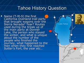
  • 1. Tahoe History QuestionTahoe History Question  Name (T-M-S) the firstName (T-M-S) the first California Overland trail partyCalifornia Overland trail party that brought wagons over thethat brought wagons over the Sierra Nevada? Year? RoutesSierra Nevada? Year? Routes used during the break up ofused during the break up of the main party at Donnerthe main party at Donner Lake, the person who stayedLake, the person who stayed the winter, and what is uniquethe winter, and what is unique about the number of theabout the number of the people who finished thepeople who finished the journey, what happened to thejourney, what happened to the men when they first reachedmen when they first reached Sutter’s Fort, the year etc…Sutter’s Fort, the year etc… . T o R e n o T o C a r s o n C ity 8 98 9 8 9 2 8 2 8 4 3 1 5 0 2 0 7 L a k e T a h o e
  • 2. You realizeYou realize that fourthat four wheel drivewheel drive does notdoes not mean fourmean four wheel stop.wheel stop. You know you’reYou know you’re a Tahoe Local if:a Tahoe Local if:
  • 3. you thought ityou thought it waswas absolutelyabsolutely appropriate toappropriate to wear flipwear flip flops, shortsflops, shorts and a downand a down parka in theparka in the morning andmorning and snow boots insnow boots in the evening.the evening. You know you’reYou know you’re a Tahoe Local if:a Tahoe Local if:
  • 4. In Week #2 We LearnedIn Week #2 We Learned  United States History prior toUnited States History prior to 18441844  Emigrant Trail beginningsEmigrant Trail beginnings  John C. Fremont – 1844John C. Fremont – 1844  Townsend-Murphy-StevensTownsend-Murphy-Stevens Party 1844Party 1844  Donner Party 1846 - 1847Donner Party 1846 - 1847  California Gold Rush 1849.California Gold Rush 1849.  Calif. boundary and Tahoe Gold.Calif. boundary and Tahoe Gold.  This week #3, we will learnThis week #3, we will learn aboutabout  Overland Trail, 40 mile desertOverland Trail, 40 mile desert  Settlers Arrive at Lake TahoeSettlers Arrive at Lake Tahoe  The Lust for Silver –Virginia CityThe Lust for Silver –Virginia City  The Cost of MiningThe Cost of Mining
  • 5. Highway 50 Wagon Train From CarsonHighway 50 Wagon Train From Carson City to Sacramento in Early JuneCity to Sacramento in Early June
  • 6. Tahoe Wagon FreighterTahoe Wagon Freighter
  • 7. Tahoe Settlers and the OverlandTahoe Settlers and the Overland Trail to CaliforniaTrail to California  The trail to California had been established by fur trappingThe trail to California had been established by fur trapping mountain men and later members of the "Emigrantmountain men and later members of the "Emigrant Societies" formed in the 1840's.Societies" formed in the 1840's.  The efforts had established a passable wagon road toThe efforts had established a passable wagon road to California over the four main obstacles:California over the four main obstacles:  Through the Rocky Mts.,Through the Rocky Mts.,  Around the Great Salt Lake Desert in Utah,Around the Great Salt Lake Desert in Utah,  Across the Forty-mile desert in NevadaAcross the Forty-mile desert in Nevada  Up and over the Sierra Nevada’s. The result was a journey ofUp and over the Sierra Nevada’s. The result was a journey of 2,000 miles in a single summer and fall, by oxen or horses2,000 miles in a single summer and fall, by oxen or horses averaging 15 miles a day, which meant a voyage of aboutaveraging 15 miles a day, which meant a voyage of about five months.five months. http://members.aol.com/DanMRosen/donner/westward.htmhttp://members.aol.com/DanMRosen/donner/westward.htm  Between 1849 to 1859 20,000 (estimate) over landBetween 1849 to 1859 20,000 (estimate) over land emigrants died– an average of 10 graves per mile.emigrants died– an average of 10 graves per mile. Meldahal,Meldahal, HardHard Road WestRoad West University of Chicago Press 2008 pg 14University of Chicago Press 2008 pg 14
  • 8. United States Expansion Started withUnited States Expansion Started with Trading PostsTrading Posts  Early 1800’s, trading posts were built forEarly 1800’s, trading posts were built for commercial reasons, not military.commercial reasons, not military.  Many trading posts used by Native AmericansMany trading posts used by Native Americans were licensed by the federal government andwere licensed by the federal government and called “factories”.called “factories”.  Tribes conceded substantial territory to theTribes conceded substantial territory to the United States ($1000 for protection) and toUnited States ($1000 for protection) and to have access the "factories" at Fort Clark. Inhave access the "factories" at Fort Clark. In 1808 Treaty of Fort Clark1808 Treaty of Fort Clark in which the Osagein which the Osage Indian Nation conceded most of Missouri.Indian Nation conceded most of Missouri.  United States purchased Louisiana in 1803 fromUnited States purchased Louisiana in 1803 from France but still had to make treaties with theFrance but still had to make treaties with the local tribes.local tribes.
  • 9. Trading PostsTrading Posts  St. Louis, Missouri, on the West side ofSt. Louis, Missouri, on the West side of the Mississippi/Missouri River confluence,the Mississippi/Missouri River confluence, was a trading post and flourished into thewas a trading post and flourished into the fur trading capital.fur trading capital.  1843 privately owned Fort Bridger1843 privately owned Fort Bridger Trading Post was built for the settlers andTrading Post was built for the settlers and pioneers as they traveled the overlandpioneers as they traveled the overland trail.trail.
  • 10. Trading PostsTrading Posts  Early traveler notesEarly traveler notes, “This fort is owned, “This fort is owned by Bridger and Basquez. [sic] It is builtby Bridger and Basquez. [sic] It is built of poles and dogwood mud. It is aof poles and dogwood mud. It is a shabby concern.”shabby concern.” http://www.wyomingtalesandtrails.com/bridger.htmlhttp://www.wyomingtalesandtrails.com/bridger.html  Many times the trading post wereMany times the trading post were broken down cabins. To the travelersbroken down cabins. To the travelers it was a welcome sight for repairingit was a welcome sight for repairing wagons, getting a hot meal and tradingwagons, getting a hot meal and trading for fresh livestock.for fresh livestock. Fort Bridger 1849
  • 11. Before Emigrants Crossed the ContinentBefore Emigrants Crossed the Continent  1804 Lewis and Clark spent five months at1804 Lewis and Clark spent five months at Fort Mandan, North Dakota obtainingFort Mandan, North Dakota obtaining information from Indians and French-Canadianinformation from Indians and French-Canadian traders. A French-Canadian trapper namedtraders. A French-Canadian trapper named Toussaint Charbonneau visited the captainsToussaint Charbonneau visited the captains with his Shoshone wife, Sacagawea.with his Shoshone wife, Sacagawea.  1807 Manuel Lisa Early organized the1807 Manuel Lisa Early organized the mountain men into a large beaver fur tradingmountain men into a large beaver fur trading companies. He built a chain of forts along thecompanies. He built a chain of forts along the Missouri River.Missouri River.  1812 John Jacob Astor set up forts in Oregon1812 John Jacob Astor set up forts in Oregon for fur trading.for fur trading. http://www.isu.edu/~trinmich/Discoverers.htmlhttp://www.isu.edu/~trinmich/Discoverers.html
  • 12. 1812 Astor’s Pacific Fur Company1812 Astor’s Pacific Fur Company Trading PostsTrading Posts (War of 1812 at the same time)(War of 1812 at the same time) http://www.thefurtrapper.com/astorians.htm
  • 13. The RendezvousThe Rendezvous  1822 William Ashley sent his men out1822 William Ashley sent his men out alone and made arrangements to meetalone and made arrangements to meet them all at a centrally-located place a yearthem all at a centrally-located place a year later and replenish his men.later and replenish his men.  At that time a wild party they called "theAt that time a wild party they called "the rendezvous." Every year throughout therendezvous." Every year throughout the 1820s and 30s it was the same: gambling,1820s and 30s it was the same: gambling, drinking, storytelling that went on fordrinking, storytelling that went on for days.days.  By the late 1830s, beaver hats were goingBy the late 1830s, beaver hats were going out of style and the silk hat were in style.out of style and the silk hat were in style. The era of the Mountain Man had passedThe era of the Mountain Man had passed and the age of the pioneer was beginning.and the age of the pioneer was beginning. http://www.isu.edu/~trinmich/Discoverers.htmlhttp://www.isu.edu/~trinmich/Discoverers.html
  • 14. 1822 Ashley’s Rendezvous -1822 Ashley’s Rendezvous - Jeremiah Johnson -1972 MovieJeremiah Johnson -1972 Movie  Jeremiah (Redford) turnsJeremiah (Redford) turns his back on civilization,his back on civilization, circa 1827, and learnscirca 1827, and learns the wilderness code ofthe wilderness code of survival. Jeremiahsurvival. Jeremiah eventually has an Indianeventually has an Indian wife and adopts a son.wife and adopts a son.  When Crow warriorsWhen Crow warriors (Montana) kill his family,(Montana) kill his family, he begins a one-manhe begins a one-man revenge mission, gainingrevenge mission, gaining legendary status as alegendary status as a warrior.warrior.
  • 15.  "In 1811, the overland party of Mr. Astor's"In 1811, the overland party of Mr. Astor's expedition found the Indians so very troublesome inexpedition found the Indians so very troublesome in the country of the Yellowstone River.the country of the Yellowstone River.  June, 1812, considering it dangerous to pass againJune, 1812, considering it dangerous to pass again by the Yellowstone River route of 1811, turnedby the Yellowstone River route of 1811, turned toward the southeast and, after several days'toward the southeast and, after several days' journey, came through the 7000 foot 'South Pass' injourney, came through the 7000 foot 'South Pass' in the month of November, 1812.the month of November, 1812.  http://en.wikipedia.org/wiki/South_Passhttp://en.wikipedia.org/wiki/South_Pass 'South Pass' November, 1812.'South Pass' November, 1812.
  • 16.  TheThe Sweetwater RiverSweetwater River is ais a tributary of the North Plattetributary of the North Platte River, approximately 150 miRiver, approximately 150 mi long, in Wyoming. It rises in atlong, in Wyoming. It rises in at the continental divide near Souththe continental divide near South Pass.Pass. http://www.pbs.org/weta/thewest/places/states/wyoming/wy_sweetwater.htmhttp://www.pbs.org/weta/thewest/places/states/wyoming/wy_sweetwater.htm
  • 17. Why Move a Family Across theWhy Move a Family Across the United States?United States?  East Coast economic depressions in 1837East Coast economic depressions in 1837 and 1841. At the same time, easternand 1841. At the same time, eastern churches formed missionary societies forchurches formed missionary societies for Christianity to evangelize the West.Christianity to evangelize the West.  The primary wagon was the “PrairieThe primary wagon was the “Prairie Schooners” usually measured 4 feet wideSchooners” usually measured 4 feet wide by 12 feet long.by 12 feet long. http://www.americanwest.com/trails/pages/oretrail.htmhttp://www.americanwest.com/trails/pages/oretrail.htm
  • 19. Prairie Schooner in Sutter FortPrairie Schooner in Sutter Fort
  • 20. Early travelers to PacificEarly travelers to Pacific  18271827 Jedediah Smith: first known American toJedediah Smith: first known American to traverse California's rugged Sierra Nevadatraverse California's rugged Sierra Nevada Mountains. From West to the East!Mountains. From West to the East!  1828,1828, Peter Skene Ogden discovered thePeter Skene Ogden discovered the Humboldt River. Canadian working for theHumboldt River. Canadian working for the Hudson’s Bay Company Explored – UtahHudson’s Bay Company Explored – Utah  18321832 Bonneville explored Oregon and Nevada’sBonneville explored Oregon and Nevada’s Great Basin.Great Basin.  1833:1833: Joseph Walker (Walker Lake - HawthornJoseph Walker (Walker Lake - Hawthorn NV) led a group of 65 trappers from the GreenNV) led a group of 65 trappers from the Green River to California and back, becoming the firstRiver to California and back, becoming the first to use what was to become the California trialto use what was to become the California trial along the Humboldt River.along the Humboldt River.  http://ourworld.compuserve.com/homepages/trailofthe49ers/trail.htmhttp://ourworld.compuserve.com/homepages/trailofthe49ers/trail.htm 1810 Alexander VonHumboldt, for scientific exploration, as one of the most prominent figures in Europe at the time. With the exception of Napoleon Bonaparte, Humboldt was the most famous man in Europe.
  • 21. Early travelers to CaliforniaEarly travelers to California  1833:1833: Bonneville suggested to Walker that he should take a partyBonneville suggested to Walker that he should take a party of men to California. The beaver population declined in the Rockyof men to California. The beaver population declined in the Rocky Mountains.Mountains.  1841:1841: The Bartelson-Bidwell Party were the first emigrantsThe Bartelson-Bidwell Party were the first emigrants through the South Pass and to take the trail to California. Theythrough the South Pass and to take the trail to California. They abandoned their wagons just west of present day Wells, Nevadaabandoned their wagons just west of present day Wells, Nevada (Hwy 80 near Utah border). Their party included the first white(Hwy 80 near Utah border). Their party included the first white woman (Nancy Kelsey) and child to make the trip. Lead by Tomwoman (Nancy Kelsey) and child to make the trip. Lead by Tom “Broken Hand” Fitzpatrick“Broken Hand” Fitzpatrick  1843:1843: The Chiles-Walker Party became the first to take wagonsThe Chiles-Walker Party became the first to take wagons across Nevada. South to Kern County then up the Central Valley.across Nevada. South to Kern County then up the Central Valley.  18441844: February 14 Fremont wrote down the sighting of Lake: February 14 Fremont wrote down the sighting of Lake Tahoe. Also in the party: Kit Carson and Tom “Broken HandTahoe. Also in the party: Kit Carson and Tom “Broken Hand Fitzpatrick. No wagons over the summitFitzpatrick. No wagons over the summit  1844:1844: November 16, 1844November 16, 1844 The Stevens Townsend Murphy PartyThe Stevens Townsend Murphy Party became the first non military group to take wagons across thebecame the first non military group to take wagons across the Sierras.Sierras.  1846:1846: Mormon BattalionMormon Battalion 1846:1846: The Donner partyThe Donner party http://ourworld.compuserve.com/homepages/trailofthe49ers/trail.htmhttp://ourworld.compuserve.com/homepages/trailofthe49ers/trail.htm
  • 23. 18331833 Joseph WalkerJoseph Walker 1833, Bonneville suggested to Walker that he1833, Bonneville suggested to Walker that he should take a party of men to California. The beavershould take a party of men to California. The beaver population declined in the Rocky Mountains.population declined in the Rocky Mountains. Walker and his party of forty men, each man takingWalker and his party of forty men, each man taking four horses.four horses. One to ride and three to carry supplies. ThisOne to ride and three to carry supplies. This included 60 pounds of dried meat per man.included 60 pounds of dried meat per man. Walker decided to follow the Humboldt River intoWalker decided to follow the Humboldt River into Nevada.Nevada.
  • 24. 18331833 Joseph WalkerJoseph Walker  When they reached the Sierra Nevada, severalWhen they reached the Sierra Nevada, several men argued that they should be allowed to gomen argued that they should be allowed to go back.back.  Walker continued and after killing and eatingWalker continued and after killing and eating some of the horses, they came out of the Sierrasome of the horses, they came out of the Sierra through the Yosemite Valley.through the Yosemite Valley.  While in California, they experienced their firstWhile in California, they experienced their first earthquake and viewed giant redwood trees.earthquake and viewed giant redwood trees.  By November 1833 they saw the Pacific Ocean.By November 1833 they saw the Pacific Ocean. They spent 3 months building up their strengthThey spent 3 months building up their strength to return. Six of the party enjoyed California soto return. Six of the party enjoyed California so much they stayed.much they stayed.
  • 25. 18331833 Joseph Walker LakeJoseph Walker Lake  On Highway 95 between Reno andOn Highway 95 between Reno and Las Vegas. Walker Lake is justLas Vegas. Walker Lake is just north of Hawthorne, Nevada.north of Hawthorne, Nevada.  Walker Lake is that it is one of onlyWalker Lake is that it is one of only six freshwater (slightly salty)six freshwater (slightly salty) terminal lakes in the world.terminal lakes in the world. PyramidPyramid Lake and four lakes in Central AsiaLake and four lakes in Central Asia being the othersbeing the others  With over a century of upriverWith over a century of upriver agricultural diversions, Walker Lakeagricultural diversions, Walker Lake has lost over three fourths of itshas lost over three fourths of its volume. The lake level has fallen byvolume. The lake level has fallen by 140 feet and the meandering shore140 feet and the meandering shore line boundary has receded 25 milesline boundary has receded 25 miles since 1906. Salt levels havesince 1906. Salt levels have increased to a point which nowincreased to a point which now threaten the trout fishery. Mono,threaten the trout fishery. Mono, Pyramid, Great Salt Lake are salty.Pyramid, Great Salt Lake are salty.
  • 28. 1841:1841: The Bartelson-Bidwell PartyThe Bartelson-Bidwell Party  The Bidwell-Bartleson Party of 1841 was theThe Bidwell-Bartleson Party of 1841 was the first organized group of non-commercial,first organized group of non-commercial, non-military emigrants with a female andnon-military emigrants with a female and child attempting to reach northern Californiachild attempting to reach northern California by way of the Humboldt River.by way of the Humboldt River.  Leaving the Oregon Trail abandoned theirLeaving the Oregon Trail abandoned their wagons, reaching the Humboldt River andwagons, reaching the Humboldt River and following the Humboldt River to its sink.following the Humboldt River to its sink.  The party crossed the Sierra Nevada withoutThe party crossed the Sierra Nevada without wagons by turning southwest, where theywagons by turning southwest, where they struggled over the mountains near (Kelseystruggled over the mountains near (Kelsey Mt) and the present Sonora Pass (seeing BigMt) and the present Sonora Pass (seeing Big Trees) into the San Joaquin Valley.Trees) into the San Joaquin Valley. http://www.emigranttrailswest.org/caltrail.htmhttp://www.emigranttrailswest.org/caltrail.htm
  • 29. 18 year old Nancy Roberts Kelsey18 year old Nancy Roberts Kelsey  Was the first white woman (with baby MarthaWas the first white woman (with baby Martha Ann on hip) to cross the Sierra Nevada with theAnn on hip) to cross the Sierra Nevada with the Bartleson Bidwell Party 1841.Bartleson Bidwell Party 1841.  Given credit for stitching the California Bear FlagGiven credit for stitching the California Bear Flag in 1846. Designed by William Todd (Mary Toddin 1846. Designed by William Todd (Mary Todd Lincoln’s nephew).Lincoln’s nephew).  Husband Benjamin KELSEY, (1813-1889): m'dHusband Benjamin KELSEY, (1813-1889): m'd 1838: emigrated to CA 1841; made and lost1838: emigrated to CA 1841; made and lost several fortunes; involved in moving cattle fromseveral fortunes; involved in moving cattle from CA to BC; had sawmill near Sonoma; mined forCA to BC; had sawmill near Sonoma; mined for gold in El Dorado County; helped establish thegold in El Dorado County; helped establish the town oftown of KelseyvilleKelseyville (near Clear Lake) in CA;(near Clear Lake) in CA; 1843 traveled to OR with his family; 18441843 traveled to OR with his family; 1844 returned to CA.returned to CA. http://www.oregonpioneers.com/1841.htmhttp://www.oregonpioneers.com/1841.htm "Where my husband"Where my husband goes I can go. I cangoes I can go. I can better stand thebetter stand the hardships of the journeyhardships of the journey than the anxieties for anthan the anxieties for an absent husband.“absent husband.“
  • 30. http://members.aol.com/DanMRosen/donner/westward.htmhttp://members.aol.com/DanMRosen/donner/westward.htm Emigrant trail, Mormon Trail, PonyEmigrant trail, Mormon Trail, Pony Express, Lincoln Highway, Highway 80Express, Lincoln Highway, Highway 80 Fremont 1843-1844 2Fremont 1843-1844 2ndnd Expedition -Expedition -@@ TahoeTahoe Fort HallFort Hall St. Joseph MO Walker’s Party 1833 Over the Sierra no wagonsWalker’s Party 1833 Over the Sierra no wagons Fremont 1845-1846 3Fremont 1845-1846 3rdrd Expedition. Bear Flag Revolt, Mexican War,Expedition. Bear Flag Revolt, Mexican War, Donner PartyDonner Party Oregon Trial 1843 Wagons to OregonOregon Trial 1843 Wagons to Oregon
  • 31. 1846 the Mormons / Donner Party1846 the Mormons / Donner Party  In 1846 the Mormons were moving from Nauvoo, Ill toIn 1846 the Mormons were moving from Nauvoo, Ill to Salt Lake City UT (by force.) Brigham Young requestedSalt Lake City UT (by force.) Brigham Young requested President Polk to finance the movement westward.President Polk to finance the movement westward. Polk did not directly pay for the move though he agreedPolk did not directly pay for the move though he agreed to give wages for soldiers and the soldiers could giveto give wages for soldiers and the soldiers could give the money to the church. The Mormons decided tothe money to the church. The Mormons decided to provided 500 soldiers for development of the Santa Feprovided 500 soldiers for development of the Santa Fe Trail for the US solders travel during to the MexicanTrail for the US solders travel during to the Mexican War.War.  Battalion members each received a $42 clothingBattalion members each received a $42 clothing allowance, paid in advance, for their one-yearallowance, paid in advance, for their one-year enlistment.enlistment.  The bulk of this money was contributed to the ChurchThe bulk of this money was contributed to the Church fund from which wagons, teams, and other necessitiesfund from which wagons, teams, and other necessities for the larger exodus were purchased.for the larger exodus were purchased.  Actual wages paid out came to nearly $30,000. Later,Actual wages paid out came to nearly $30,000. Later, Battalion members returning from California, at JohnBattalion members returning from California, at John Sutter's mill, contributed $17,000 in gold to the SaltSutter's mill, contributed $17,000 in gold to the Salt Lake City settlement.Lake City settlement. http://www.lds.org/library/pio_sto/Pioneer_Trail/12_Council_Bluffs.htmlhttp://www.lds.org/library/pio_sto/Pioneer_Trail/12_Council_Bluffs.html
  • 32. The 1846 MormonsThe 1846 Mormons  From 1846 to 1869 12,000 MormonsFrom 1846 to 1869 12,000 Mormons moved from Nauvoo, Illinois to Saltmoved from Nauvoo, Illinois to Salt Lake City along the same initial trail.Lake City along the same initial trail.  February 1846 started the move toFebruary 1846 started the move to Salt Lake setting up roads and foodSalt Lake setting up roads and food supplies along the way for futuresupplies along the way for future Church members.Church members.
  • 33. 1848 Mormons Heading1848 Mormons Heading EastEast OverOver the Sierra Nevada using Carson Passthe Sierra Nevada using Carson Pass  On July 3, 1848 the party started eastOn July 3, 1848 the party started east clearing the road for wagon travel. (Eastclearing the road for wagon travel. (East of Placerville off Highway 50)of Placerville off Highway 50)  Kept 300 animals at a Park owned byKept 300 animals at a Park owned by James Sly - now known as Sly Park.James Sly - now known as Sly Park.  3 scouts killed near a spring - now known3 scouts killed near a spring - now known as Tragedy Springs.as Tragedy Springs.  Went over a pass that had a name carvedWent over a pass that had a name carved in a tree “Carson” now Carson Pass.in a tree “Carson” now Carson Pass.  Having hope that they could make it theyHaving hope that they could make it they named it Hope Valley.named it Hope Valley.  Followed the Carson River through CarsonFollowed the Carson River through Carson Valley, 40 mile desert.Valley, 40 mile desert.
  • 34. S.A Mitchells 1846 MapS.A Mitchells 1846 Map San Diego 1847 Coloma 1848 Salt Lake City 1846 Nauvoo IA 1846 Mexican War 1846 to 1848 Mormon Battalion Discharged July 1847 250 travel North Disbanded Mormon Battalion June 1848 Mormon Battalion July 20, 1846 Leavenworth Kansas
  • 35. The Forty-Mile Desert -The Forty-Mile Desert - 40 miles to water40 miles to water
  • 36.  Carson City Fallon   Current Highway 50 Carson River 40 mile Desert Truckee River 40 mile Desert
  • 37. **40 Mile desert Carson River route40 Mile desert Carson River route  A footnote to the journal of Lorenzo Sawyer (1850)A footnote to the journal of Lorenzo Sawyer (1850) by Edward Eberstadt stated that one emigrant onby Edward Eberstadt stated that one emigrant on the Carson route countedthe Carson route counted  1061 dead mules,1061 dead mules,  4,960 dead horses, and4,960 dead horses, and  3750 dead oxen and cows.3750 dead oxen and cows.  Also noted were 963 graves andAlso noted were 963 graves and  An estimate that probably 5000 persons perishedAn estimate that probably 5000 persons perished during 1850.during 1850.  John Wood (1850) wrote a vivid account of hisJohn Wood (1850) wrote a vivid account of his sufferings on the desert and observed that somesufferings on the desert and observed that some 3000 wagons and 3 million dollars worth of property3000 wagons and 3 million dollars worth of property lay abandoned on the Carson Route. Such was thelay abandoned on the Carson Route. Such was the desert roll of Destruction Valley.desert roll of Destruction Valley. Everett W. HarrisEverett W. Harris TheThe Emigrants Passed This WayEmigrants Passed This Way Western Trails Research Associates pg 90Western Trails Research Associates pg 90
  • 38. Mark TwainMark Twain Carson 1861Carson 1861 40 Mile Desert40 Mile Desert Route and RagtownRoute and Ragtown
  • 40. HeadingHeading EastEast Over the SierraOver the Sierra Nevada Mormon/Carson Pass RouteNevada Mormon/Carson Pass Route  ““The most successful road opening in westernThe most successful road opening in western history.”history.” www.emigranttrailswest.orgwww.emigranttrailswest.org  From the Overland Trail cross roads, four branchFrom the Overland Trail cross roads, four branch roads led to the Gold mines in California.roads led to the Gold mines in California.  Initially emigrants were divided equally overInitially emigrants were divided equally over those land routes, Beckworth (North), Hennessthose land routes, Beckworth (North), Henness Pass, Donner (middle) and Mormon Carson PassPass, Donner (middle) and Mormon Carson Pass (South). Just two years later, by 1850, 95(South). Just two years later, by 1850, 95 percent of the ensuing emigrants followed thepercent of the ensuing emigrants followed the Mormon Carson Pass route south of Lake Tahoe.Mormon Carson Pass route south of Lake Tahoe.  Mormon/Carson Pass 3 river crossingsMormon/Carson Pass 3 river crossings Truckee/Donner Pass 23 river crossings.Truckee/Donner Pass 23 river crossings. Tahoe DailyTahoe Daily Tribune Denise SloanTribune Denise Sloan How Local is a Local?How Local is a Local? Page 18 1998Page 18 1998
  • 41. First European Tahoe Visitors-First European Tahoe Visitors- Trans – Sierra passagesTrans – Sierra passages  1850-1851 (1848 Landauer) Col. John Calhoun1850-1851 (1848 Landauer) Col. John Calhoun “Cock-eye” Johnson visited Lake Valley over“Cock-eye” Johnson visited Lake Valley over Echo summit. (No official journal entry) In 1853Echo summit. (No official journal entry) In 1853 Rubicon Gorge.Rubicon Gorge.  Placerville lawyer, rancher, explorer, StatePlacerville lawyer, rancher, explorer, State Assembly member and a major participant in ElAssembly member and a major participant in El Dorado's only “Indian War.”Dorado's only “Indian War.”  He allowed up to 800 militia to stay on his “SixHe allowed up to 800 militia to stay on his “Six Mile” (east of Placerville) ranch.Mile” (east of Placerville) ranch.  Johnson’s Pass (lower elevation than Carson’sJohnson’s Pass (lower elevation than Carson’s pass) at the south end of Tahoe Valley in thepass) at the south end of Tahoe Valley in the spring of 1850-51 (1848 Landauer) andspring of 1850-51 (1848 Landauer) and followed the South fork of the American Riverfollowed the South fork of the American River back to Placerville.back to Placerville.
  • 43. Johnson's PassJohnson's Pass  The 1849 rush brought wagon trains across the HighThe 1849 rush brought wagon trains across the High Sierra.Sierra.  Most of the wagons moved south of Tahoe up WoodfordMost of the wagons moved south of Tahoe up Woodford Canyon, through Hope Valley and over Kit Carson PassCanyon, through Hope Valley and over Kit Carson Pass (Route of today's Highway 88). Carson Pass is high and(Route of today's Highway 88). Carson Pass is high and winter created severe wind and snow problems.winter created severe wind and snow problems.  Johnson's Pass was lower and less exposed to theJohnson's Pass was lower and less exposed to the harsh weather mostly being protected by the Southharsh weather mostly being protected by the South Fork of the American River canyon.Fork of the American River canyon.  Its drawback was the sharp rise from the Lake Valley,Its drawback was the sharp rise from the Lake Valley, but the determined pioneers still moved up Johnson'sbut the determined pioneers still moved up Johnson's Hill (Echo Summit). Wagons were block and tackled upHill (Echo Summit). Wagons were block and tackled up 1,100 feet in a distance of three quarters of a mile. The1,100 feet in a distance of three quarters of a mile. The rise was to a flat area called "Cape Horn." From therise was to a flat area called "Cape Horn." From the Horn, the trail made two switch backs, then over theHorn, the trail made two switch backs, then over the pass and down the South Fork of the American Riverpass and down the South Fork of the American River canyon to Placerville.canyon to Placerville. http://www.americana-tahoe.com/Jimhttp://www.americana-tahoe.com/Jim %20Hubbard/HWY%2050.html%20Hubbard/HWY%2050.html
  • 44. Col. John Calhoun “Cock-Eye” JohnsonCol. John Calhoun “Cock-Eye” Johnson  1850-51 (48) – the Johnson (Echo Summit) cut1850-51 (48) – the Johnson (Echo Summit) cut off shortened the Mormon (Carson Pass) routeoff shortened the Mormon (Carson Pass) route by several miles.by several miles. Laundaur pg 61Laundaur pg 61  Going East, once in Lake Valley the trail turnedGoing East, once in Lake Valley the trail turned south (over to what will be known as Luther'ssouth (over to what will be known as Luther's Pass in 1854) to meet the Mormon EmigrantPass in 1854) to meet the Mormon Emigrant Trail in Hope Valley.Trail in Hope Valley.  1860 the pony express trail (initially went over1860 the pony express trail (initially went over Luther's Pass) then changed to the shorter LakeLuther's Pass) then changed to the shorter Lake Valley using Kingsbury Grade /Daggett’s Pass.Valley using Kingsbury Grade /Daggett’s Pass.  Three years later the popular (shorter) trailThree years later the popular (shorter) trail went over the top of Cave Rock over the Carsonwent over the top of Cave Rock over the Carson Range down to Eagle Valley (Carson City).Range down to Eagle Valley (Carson City).
  • 46. Toward Lake Tahoe on Luther’s Pass Old Luther’s Pass Road Current Luther’s Pass Road Highway 89 Pickett’s Junction To Kirkwood Ski Resort Highway 88/89 North
  • 47. 1855 (54) Asa Hawley1855 (54) Asa Hawley LandauerLandauer  Built a graded road to the top of Echo Summit that ledBuilt a graded road to the top of Echo Summit that led from his door step in Upper Lake Valley (Christmasfrom his door step in Upper Lake Valley (Christmas Valley).Valley).  Initially he was a way station operator in Elkhorn MillInitially he was a way station operator in Elkhorn Mill east of Placerville.east of Placerville.  ““Tahoe Natives would not let me fish the streams.”Tahoe Natives would not let me fish the streams.”  First year round resident in the Tahoe Basin. (notFirst year round resident in the Tahoe Basin. (not verifiable).verifiable).  1856 or 1857 tried to measure Lake Tahoe’s1856 or 1857 tried to measure Lake Tahoe’s circumference and locate an outlet, with James Greencircumference and locate an outlet, with James Green and John A.Thompson, by counting a half mile distanceand John A.Thompson, by counting a half mile distance by pace and timing how long it took to travel thatby pace and timing how long it took to travel that distance with a row boat.distance with a row boat.  Their conclusion was Lake Tahoe circumference 150Their conclusion was Lake Tahoe circumference 150 miles!! Actually 72 miles.miles!! Actually 72 miles.  1870, moved to Kings Canyon, Carson City then to1870, moved to Kings Canyon, Carson City then to Latrobe CA, died in Yerington NV 1899.Latrobe CA, died in Yerington NV 1899.
  • 48. Kings Canyon Road Clear Creek Canyon Road Current highway 50 Spooner Summit
  • 49. KingsCanyon 1863 Saga I pg 236 1860 Saga I pg 236 1851 (54) E V A D A N
  • 50. Tahoe 1850’s to 1860’sTahoe 1850’s to 1860’s  Few structures, several trails marked,Few structures, several trails marked, wagon and coaches and a few boats.wagon and coaches and a few boats.  Few people spent the short summerFew people spent the short summer haying, grazing cattle, operating wayhaying, grazing cattle, operating way stations and saloons, livery stables andstations and saloons, livery stables and trading posts.trading posts.  Natives continue to follow their traditionalNatives continue to follow their traditional ways of fishing hunting gathering food andways of fishing hunting gathering food and materials for winter.materials for winter.
  • 53. Hawley’s Grade 1855(54)Hawley’s Grade 1855(54)  Drive on South Upper Truckee untilDrive on South Upper Truckee until you see this sign.you see this sign.
  • 54. Views from Hawley’s GradeViews from Hawley’s Grade
  • 55. Bottom of Old Meyers Grade -1857Bottom of Old Meyers Grade -1857
  • 56. Top of Old Meyers Grade -Top of Old Meyers Grade - Cape HornCape Horn  This road still can beThis road still can be used in emergenciesused in emergencies Meyers grade 1942 -1949 Old Meyers Grade 1857 Johnson Cutoff 1850-51 (48) To Echo Lakes
  • 57. U n it e d S t a te s 1 8 5 4 N o rt h e rn F re e S ta t e s S o u th e rn S la v e S ta te s P o p u la r S o v e re ig n t y F e d e ra l (U n io n ) Te rrit o rie s K a n s a s fre e /s la v e ? N e b ra s k a f re e / s la v e ? 1 8 4 6 M isso u ri M a in e 1 8 5 0 3 6 3 0 ” 3 6 3 0 ”
  • 58. You know you’reYou know you’re a Tahoe Local if:a Tahoe Local if: You realizeYou realize when youwhen you change thechange the studdedstudded snow tires tosnow tires to regular tiresregular tires you canyou can decrease thedecrease the radioradio volume.volume.
  • 59. Last Hour We LearnedLast Hour We Learned  Chapter 5 SettlersChapter 5 Settlers Arrive at Lake TahoeArrive at Lake Tahoe  This hour we willThis hour we will learn aboutlearn about  The Lust for SilverThe Lust for Silver  Sutro: tunnelSutro: tunnel  Diedesheimer: squareDiedesheimer: square set miningset mining  Hallidie: cableHallidie: cable  The cost of miningThe cost of mining
  • 60. Chapter 6 Lust for SilverChapter 6 Lust for Silver  Silver StateSilver State
  • 61. What Was Discovered in VirginiaWhat Was Discovered in Virginia City in 1859?City in 1859?  Gold and SilverGold and Silver..
  • 62. Where was the Gold?Where was the Gold?  It is somewhat ironic thatIt is somewhat ironic that the California 49’ers thatthe California 49’ers that traveled across Nevada totraveled across Nevada to the California gold fieldsthe California gold fields walked over far more goldwalked over far more gold than would ever be minedthan would ever be mined in the “Golden State”.in the “Golden State”. Nevada’s Carlin and BattleNevada’s Carlin and Battle Mountain Trends haveMountain Trends have proven to be two of theproven to be two of the world’s most prolific goldworld’s most prolific gold fields.fields. http://www.nevadamining.org/documents/Econhttp://www.nevadamining.org/documents/Econ omic_Overview_07.pdf page 12omic_Overview_07.pdf page 12 N e v a d a s ilv e r California gold Sierra Nevada Nevada Gold
  • 63. 1859 Utah Territory Near Virginia1859 Utah Territory Near Virginia CityCity  1857 Brothers Ethan and Hosea Grosch found an1857 Brothers Ethan and Hosea Grosch found an rich ore sample. Unfortunately both died beforerich ore sample. Unfortunately both died before (tetanus and froze to death) the assay and put a(tetanus and froze to death) the assay and put a claim on the land.claim on the land.  1859 Promising gold vein was found by James “Old1859 Promising gold vein was found by James “Old Virginia” Finney, Alex Henderson and othersVirginia” Finney, Alex Henderson and others $20/day - mild strike.$20/day - mild strike.  Pat McLaughlin and Peter O’Riley in Gold Hill $200Pat McLaughlin and Peter O’Riley in Gold Hill $200 gold/day and were troubled with “this blue stuffgold/day and were troubled with “this blue stuff from the rising of the sun to the going downfrom the rising of the sun to the going down thereof.”thereof.”  ““Blue stuff” was silver oreBlue stuff” was silver ore worth overworth over $2000 a ton$2000 a ton
  • 64. 1859 Utah Territory Near Virginia1859 Utah Territory Near Virginia CityCity  Henry Comstock informed Mclaughlin and O”RileyHenry Comstock informed Mclaughlin and O”Riley they were on his land that he claimed for grazing.they were on his land that he claimed for grazing. They were persuaded to join his partnership andThey were persuaded to join his partnership and called the mine Ophir Mine.called the mine Ophir Mine.  Comstock became a partner and several otherComstock became a partner and several other mine owners.mine owners.  After the ore assay in Grass Valley CA theAfter the ore assay in Grass Valley CA the Comstock Lode rush began. Fifty-niners!Comstock Lode rush began. Fifty-niners!  The pilgrimage from California to Utah TerritoryThe pilgrimage from California to Utah Territory (Nevada) caused crowded roads, inflation of(Nevada) caused crowded roads, inflation of goods and Way Stations to spring up.goods and Way Stations to spring up.
  • 65. US and Nevada HistoryUS and Nevada History  1859: Gold and Silver Up1859: Gold and Silver Up to $8 million per day wasto $8 million per day was mined in Virginia City. Themined in Virginia City. The most prosperous silvermost prosperous silver veins were up to 10 feetveins were up to 10 feet wide.wide.  The land that wouldThe land that would eventually be the State ofeventually be the State of Nevada had less than 300Nevada had less than 300 non-native Americannon-native American population.population. Bouton “Nevada Trivia” Rutledge Hill Press 1999 page 23  The North was not worriedThe North was not worried about losing Virginia City’sabout losing Virginia City’s gold and silver to thegold and silver to the South because it was aSouth because it was a Federal territory.Federal territory. Web site by Casino News Virginia City Nevada
  • 66. Virginia City Required Heavy Equipment ToVirginia City Required Heavy Equipment To Dig the mines in the Early 1860’s. Most ofDig the mines in the Early 1860’s. Most of the Equipment Came Via Sacramentothe Equipment Came Via Sacramento Through South Lake Tahoe on a Toll road.Through South Lake Tahoe on a Toll road. What is a Toll road?What is a Toll road?  A road on which you have to pay money to use.A road on which you have to pay money to use.  A way for the new State of California to pay forA way for the new State of California to pay for the road construction. State Constitution 1849.the road construction. State Constitution 1849.  Kingsbury and McDonald surveyed the road.Kingsbury and McDonald surveyed the road.  $1.35 million of tolls was collected by all the toll$1.35 million of tolls was collected by all the toll houses the first year of operation in 1860.houses the first year of operation in 1860. Saga ISaga I pg 366pg 366  Later the money made in tolls proved to be aLater the money made in tolls proved to be a logical investment decision to make a railroadlogical investment decision to make a railroad from Sacramento to Reno.from Sacramento to Reno.
  • 67. Nevada Toll Road Fees of theNevada Toll Road Fees of the 1860s1860s  TollToll  $2 per wagon and one span of horses$2 per wagon and one span of horses  25 cents per extra horse, half price for25 cents per extra horse, half price for empty, returning freight wagonsempty, returning freight wagons  25 cents per extra horse, half price for25 cents per extra horse, half price for empty, returning freight wagonsempty, returning freight wagons  $1.50 for a person on horseback$1.50 for a person on horseback  10 cents per sheep or hog10 cents per sheep or hog  12 cents for a person's dog12 cents for a person's dog  http://www.nevadaappeal.com/article/20060709/NEWS/107090090http://www.nevadaappeal.com/article/20060709/NEWS/107090090
  • 68. Kingsbury GradeKingsbury Grade  The Kingsbury Grade wagon roadThe Kingsbury Grade wagon road was built in 1860 by Kingsbury andwas built in 1860 by Kingsbury and McDonald as a replacement of theMcDonald as a replacement of the old (1855) Daggett Pass horse Trail.old (1855) Daggett Pass horse Trail.  The new road shortened the distanceThe new road shortened the distance between Sacramento and Virginiabetween Sacramento and Virginia City by 15 miles. (Approximately fullCity by 15 miles. (Approximately full one day travel)one day travel)
  • 69.
  • 70. True/False Heavy Traffic CongestionTrue/False Heavy Traffic Congestion is New to the Tahoe Area?is New to the Tahoe Area?
  • 71. FalseFalse It had been said, it could take up to two hours toIt had been said, it could take up to two hours to get back on the road if you got off.get back on the road if you got off.
  • 72.
  • 74. Problems with Mining Mt. DavidsonProblems with Mining Mt. Davidson (Virginia City)(Virginia City)  Excavation with excess water and heatExcavation with excess water and heat (workers 10 minutes at a time)(workers 10 minutes at a time)  Mine walls would cave in that were notMine walls would cave in that were not supported. Even if supported sometimes.supported. Even if supported sometimes.  Proposed solution was given by AdolfProposed solution was given by Adolf Sutro to dig a tunnel in the side of theSutro to dig a tunnel in the side of the mountain to extract the ore and drain themountain to extract the ore and drain the excess water.excess water.  Mining stopped not due to lack of silverMining stopped not due to lack of silver but the cost of removal.but the cost of removal.  Most mines terminated operations in theMost mines terminated operations in the spring of 1877.spring of 1877. Laundauer pg 56Laundauer pg 56
  • 75. In 1867 900ft underground, lit by an improvised flash -- a burningIn 1867 900ft underground, lit by an improvised flash -- a burning magnesium wire, O'Sullivan photographed the miners in tunnels,magnesium wire, O'Sullivan photographed the miners in tunnels, shafts, and lifts. During the winter of 1867-68, in Virginia City, Nevada,shafts, and lifts. During the winter of 1867-68, in Virginia City, Nevada, he took the first underground mining pictures in America. Deep inhe took the first underground mining pictures in America. Deep in mines where temperatures reached 130 degreesmines where temperatures reached 130 degrees
  • 76. Occupational HazardsOccupational Hazards  Working 2,000 feet undergroundWorking 2,000 feet underground brought severe occupationalbrought severe occupational hazards - heat exhaustion,hazards - heat exhaustion, pneumonia, silicosis (miner'spneumonia, silicosis (miner's lung) and rheumatism.lung) and rheumatism.  Heat increased 5 degreesHeat increased 5 degrees Fahrenheit every hundred feetFahrenheit every hundred feet depth. At 3,000 feet, clouds ofdepth. At 3,000 feet, clouds of steam obscured a man's work,steam obscured a man's work, wooden pick handles became sowooden pick handles became so hot that miners had to usehot that miners had to use gloves.gloves.  Work time was reduced to 15Work time was reduced to 15 minutes out of each hour, andminutes out of each hour, and the ice allotment went up to 95the ice allotment went up to 95 pounds a day per man. (The icepounds a day per man. (The ice came from Truckee icecame from Truckee ice harvesting area.)harvesting area.) http://www.nevoldwest.com/Mining/mining.htmlhttp://www.nevoldwest.com/Mining/mining.html
  • 77. Adolf SutroAdolf Sutro  1859 established a small mill, called the Sutro1859 established a small mill, called the Sutro Metallurgical Works and improved process ofMetallurgical Works and improved process of amalgamation.amalgamation.  1879 Sutro sold his tunnel to the McCalmont1879 Sutro sold his tunnel to the McCalmont Brothers, and countless lesser investors, andBrothers, and countless lesser investors, and returned to San Francisco.returned to San Francisco.  At one time Sutro owned one-twelfth of theAt one time Sutro owned one-twelfth of the acreage of San Francisco.acreage of San Francisco.  1880 purchased the Cliff House, and one1880 purchased the Cliff House, and one thousand acres of land facing the ocean, nowthousand acres of land facing the ocean, now called Sutro heights.called Sutro heights.
  • 78. Adolf SutroAdolf Sutro  He built the Sutro saltwater baths, Cliff House onHe built the Sutro saltwater baths, Cliff House on the Pacific Ocean.the Pacific Ocean.  He planted Sutro Forest.He planted Sutro Forest.  Sutro Heights ParkSutro Heights Park  1894 he ran for mayor on the Populist ticket and1894 he ran for mayor on the Populist ticket and served one two-year term.served one two-year term.  August 8, 1898 Sutro died in San FranciscoAugust 8, 1898 Sutro died in San Francisco  He owned the finest private library in America,He owned the finest private library in America, much of which was destroyed during the fire thatmuch of which was destroyed during the fire that followed the Great Earthquake of 1906.followed the Great Earthquake of 1906.
  • 79. Sutro Heights parkSutro Heights park
  • 80.  Sutro purchasedSutro purchased the Cliff House inthe Cliff House in 1883 and tried1883 and tried unsuccessfully tounsuccessfully to manage it himselfmanage it himself
  • 81. The Sutro TunnelThe Sutro Tunnel  Adolph Sutro conceived the tunnel as early asAdolph Sutro conceived the tunnel as early as 1860, when he saw the steaming hot water1860, when he saw the steaming hot water that made the Comstock mines so difficult tothat made the Comstock mines so difficult to work. His idea was to tunnel about six miles towork. His idea was to tunnel about six miles to provide drainage for the mines.provide drainage for the mines.  He didn't get financing for the project until lateHe didn't get financing for the project until late 1869, when a disastrous mine fire “Yellow1869, when a disastrous mine fire “Yellow Jacket”Jacket” deep in the Comstock mines killeddeep in the Comstock mines killed hundreds of miners. His tunnel would havehundreds of miners. His tunnel would have offered an escape route that would have savedoffered an escape route that would have saved many lives.many lives.  http://69.69.245.68/ghosts/dayton/sutro/index.htmhttp://69.69.245.68/ghosts/dayton/sutro/index.htm
  • 82.
  • 83. The Sutro TunnelThe Sutro Tunnel  By completion, the mines depth was well belowBy completion, the mines depth was well below the Sutro tunnel opening. The tunnel finallythe Sutro tunnel opening. The tunnel finally connected to the Savage Mine in July, 1878.connected to the Savage Mine in July, 1878. One reason for the delay was funding but theOne reason for the delay was funding but the other was the mine owners did not want to payother was the mine owners did not want to pay the extra cost of $2.00 per ton fee to haul orethe extra cost of $2.00 per ton fee to haul ore out of the underground rail way.out of the underground rail way.  Sutro's project had completed 33,315 feet ofSutro's project had completed 33,315 feet of lateral tunneling. (6.3 miles)lateral tunneling. (6.3 miles)  In 1880, alone, two billion (2,000,000,000)In 1880, alone, two billion (2,000,000,000) gallons of water pumped through it. The minesgallons of water pumped through it. The mines did drain the shafts into Dayton NV, using thedid drain the shafts into Dayton NV, using the Sutro Tunnel until 1940.Sutro Tunnel until 1940. http://69.69.245.68/ghosts/dayton/sutro/index.htmhttp://69.69.245.68/ghosts/dayton/sutro/index.htm
  • 84. **Problem with the Sutro TunnelProblem with the Sutro Tunnel Mt Davidson Sutro Tunnel THE COMSTOCK LODE SECTION ALONG THE SUTRO TUNNEL (looking south-south west) Dayton Virginia City Combination shaft 3,250 ft. 2,484 ft. Comstock Lode (Water was recorded to be 170° at the depth 3000 foot level(Water was recorded to be 170° at the depth 3000 foot level an unwanted hot spring bath housean unwanted hot spring bath house)) Beck WilliamsBeck Williams California: A History of the Golden StateCalifornia: A History of the Golden State 1972 DoubleDay and Co. Inc. Page 1501972 DoubleDay and Co. Inc. Page 150
  • 85. Virginia City Boom Years 1860-1880Virginia City Boom Years 1860-1880  By 1860, Virginia City was a booming miningBy 1860, Virginia City was a booming mining community, and over the years, largecommunity, and over the years, large quantities of silver ore, worth $400,000,000quantities of silver ore, worth $400,000,000 were mined.were mined.  There were more than 400 (to 700) miles ofThere were more than 400 (to 700) miles of tunnels and shafts under the Virginia City area.tunnels and shafts under the Virginia City area. The miner's working conditions were veryThe miner's working conditions were very difficult. There was no electricity to illuminatedifficult. There was no electricity to illuminate the working areas; all lighting was bythe working areas; all lighting was by candlelight. Oxygen in the mines was limited,candlelight. Oxygen in the mines was limited, and fire was a constant danger.and fire was a constant danger.  What is a miners Canary? (over heated TeflonWhat is a miners Canary? (over heated Teflon coated pan)coated pan)  http://mishalov.net/virginiacity602/virginiacity602.htmlhttp://mishalov.net/virginiacity602/virginiacity602.html
  • 86. Philipp DeidesheimerPhilipp Deidesheimer  It was the workers who made Virginia City aIt was the workers who made Virginia City a reality.reality.  There were the 3000 miners who toiled underThere were the 3000 miners who toiled under some unbelievable conditions.some unbelievable conditions.  Working 8 hours a day, 5 days a week inWorking 8 hours a day, 5 days a week in temperatures often hovering at 130 degrees fortemperatures often hovering at 130 degrees for $4.00 per day. As the ore was removed, the$4.00 per day. As the ore was removed, the caverns would sometimes collapse crushing thecaverns would sometimes collapse crushing the men instantly under tons of rock.men instantly under tons of rock.  1860, Philipp Deidesheimer brought his invention1860, Philipp Deidesheimer brought his invention of “square set” timbering.of “square set” timbering.  Not another miner ever lost his life due to a cave-Not another miner ever lost his life due to a cave- in, if this method of timbering was employed.in, if this method of timbering was employed. http://www.virginiacity-nv.com/our%20history/ourhistory.htmhttp://www.virginiacity-nv.com/our%20history/ourhistory.htm
  • 87. Square SetsSquare Sets  Square sets are a 12” x 12” timbers.Square sets are a 12” x 12” timbers.  Placing the square sets in the minesPlacing the square sets in the mines inspired innovative logginginspired innovative logging techniques.techniques.  To this day, the Tahoe Basin and theTo this day, the Tahoe Basin and the eastern slope of the Sierra’s showseastern slope of the Sierra’s shows the scars of strip lumbering forthe scars of strip lumbering for Virginia City mines.Virginia City mines.
  • 88. Square Set TimberingSquare Set Timbering
  • 89.
  • 90.
  • 91. Andrew HallidieAndrew Hallidie  The miners faced daily was death due to a snappedThe miners faced daily was death due to a snapped hempen rope on the hoisting cages. Being in a cagehempen rope on the hoisting cages. Being in a cage falling 2000 feet down guaranteed no survivors.falling 2000 feet down guaranteed no survivors.  1864 Mr. Hallidie devised a flat woven wire cable about1864 Mr. Hallidie devised a flat woven wire cable about 4" wide and 1/2 " thick that was attached to the cages.4" wide and 1/2 " thick that was attached to the cages.  It was the same invention he used in constructing theIt was the same invention he used in constructing the San Francisco cable car system in 1873. The installationSan Francisco cable car system in 1873. The installation of this cable, along with safety clutches, insured a safeof this cable, along with safety clutches, insured a safe ride up and down the shafts.ride up and down the shafts. http://www.virginiacity-nv.com/our%20history/ourhistory.htmhttp://www.virginiacity-nv.com/our%20history/ourhistory.htm
  • 92. Mercury Contamination of theMercury Contamination of the Carson RiverCarson River  Gold and silver were initiallyGold and silver were initially extracted from the ores usingextracted from the ores using the mercury amalgamationthe mercury amalgamation process. Amalgamation is theprocess. Amalgamation is the collection of fine gold-silvercollection of fine gold-silver particles in coatings ofparticles in coatings of mercury. The mercury is thenmercury. The mercury is then collected and heatedcollected and heated (evaporated) away from the(evaporated) away from the precious metals andprecious metals and recondensed for reuse.recondensed for reuse. ftp://comstock.nbmg.unr.edu/pub/doxftp://comstock.nbmg.unr.edu/pub/dox /nl/nl17a.htm/nl/nl17a.htm  Mercury amalgamationMercury amalgamation process resulted in 25% lossprocess resulted in 25% loss of the gold. In 1896 a newof the gold. In 1896 a new cyanide process recovered incyanide process recovered in the gold and silver in thethe gold and silver in the tailingstailings.. L.J. EttingerL.J. Ettinger The Best of Virginia City and theThe Best of Virginia City and the ComstockComstock 1995 pg 81995 pg 8
  • 93. How Much Does it Cost to Mine Gold?How Much Does it Cost to Mine Gold?  The density of mercury is between that of gold and the gravelThe density of mercury is between that of gold and the gravel slurry, so gold and gold-mercury amalgam would sink, while theslurry, so gold and gold-mercury amalgam would sink, while the sand and gravel would pass over the mercury and through thesand and gravel would pass over the mercury and through the sluice.sluice.  Most of the mercury used in gold recovery in California wasMost of the mercury used in gold recovery in California was obtained from the Coast Ranges mercury belt on the west side ofobtained from the Coast Ranges mercury belt on the west side of California's Central Valley. New Almaden south San Jose.California's Central Valley. New Almaden south San Jose.  1995 coal that is consumed for energy production is estimated to1995 coal that is consumed for energy production is estimated to have put 50 million tons of mercury in the atmosphere.have put 50 million tons of mercury in the atmosphere.  The concentration of CH3Hg+ generally increases by a factor ofThe concentration of CH3Hg+ generally increases by a factor of ten with each step up the food chain, a process known asten with each step up the food chain, a process known as biomagnification.biomagnification. Mercury is stored in the fat cells of fish. YouMercury is stored in the fat cells of fish. You may be able to drink the water but not eat the fish.may be able to drink the water but not eat the fish.  One gram of mercury in eight millions liters of water is consideredOne gram of mercury in eight millions liters of water is considered toxic to fetuses.toxic to fetuses.  In California, as of 1999, there were fish consumption advisoriesIn California, as of 1999, there were fish consumption advisories for mercury in 13 waterbodies, including the San Francisco Bayfor mercury in 13 waterbodies, including the San Francisco Bay and Delta Region and several areas in the Coast Ranges affectedand Delta Region and several areas in the Coast Ranges affected by mercury mining.by mercury mining.  ca.water.usgs.gov/mercury/fsoc100/htmlca.water.usgs.gov/mercury/fsoc100/html
  • 94. Mercury Contamination of theMercury Contamination of the Carson RiverCarson River  Approximately 15 million pounds of mercuryApproximately 15 million pounds of mercury filtered to the Carson River drainage system infiltered to the Carson River drainage system in the milling of ore containing.the milling of ore containing.  Approximately 8 million ounces of gold and 192Approximately 8 million ounces of gold and 192 million ounces of silver were also lost.million ounces of silver were also lost.  Tremendous amounts of mercury, gold, andTremendous amounts of mercury, gold, and silver now reside in mill tailings and the channelsilver now reside in mill tailings and the channel sediments and flood plain deposits of thesediments and flood plain deposits of the Carson River, largely along the 70 mile stretchCarson River, largely along the 70 mile stretch between Carson City and Fallon, Nevada.between Carson City and Fallon, Nevada.  As many as 200 mills may have processedAs many as 200 mills may have processed Comstock ore at one time or another within theComstock ore at one time or another within the Carson and Truckee River watersheds.Carson and Truckee River watersheds. ftp://comstock.nbmg.unr.edu/pub/dox/nl/nl17a.htmftp://comstock.nbmg.unr.edu/pub/dox/nl/nl17a.htm
  • 95. Money Money MoneyMoney Money Money  How did speculators put a value on the land?How did speculators put a value on the land? They priced mines by the foot. TheThey priced mines by the foot. The Comstock's richest mine, the Ophir, lay alongComstock's richest mine, the Ophir, lay along a claim nearly a quarter of a mile in length,a claim nearly a quarter of a mile in length, and was quoted at $4,000 per foot.and was quoted at $4,000 per foot.  Mark Twain, "Feet (stock) that went beggingMark Twain, "Feet (stock) that went begging yesterday were worth a brick house today,"yesterday were worth a brick house today,"  The $400 million Comstock Lode causedThe $400 million Comstock Lode caused Virginia City, Nevada, to have a population ofVirginia City, Nevada, to have a population of 30,000, the second biggest city in the West. A30,000, the second biggest city in the West. A generation of regional tycoons arose. Theirgeneration of regional tycoons arose. Their names were Ralston, Sharon, Fair, Flood...names were Ralston, Sharon, Fair, Flood... http://www.calliope.org/gold/gold3.htmlhttp://www.calliope.org/gold/gold3.html
  • 96. Not All investors Made MoneyNot All investors Made Money Mark TwainMark Twain ““A mine is a hole in the ground ownedA mine is a hole in the ground owned by a liar!”by a liar!”  Shares of non-producers mines Alpha,Shares of non-producers mines Alpha, Exchequer, Bullion-Ward soldExchequer, Bullion-Ward sold thousands of worthless shares on thethousands of worthless shares on the San Francisco Mining Exchange.San Francisco Mining Exchange.  ““Comstock produced 29 millionaires inComstock produced 29 millionaires in an environment where more than 1000an environment where more than 1000 mining companies were formed ofmining companies were formed of which 19 ever paid dividends.which 19 ever paid dividends.  More money was lost in theMore money was lost in the unregulated mining stock marketunregulated mining stock market through assessments and stockthrough assessments and stock manipulation than was ever producedmanipulation than was ever produced in gold and silver.”in gold and silver.” L.J. EttingerL.J. Ettinger The Best ofThe Best of Virginia City and the ComstockVirginia City and the Comstock 1995 pg 81995 pg 8
  • 97. Comstock Lode EndedComstock Lode Ended  1898 ghost town.1898 ghost town.  Mining industry destroyed much ofMining industry destroyed much of the land wherever it operated.the land wherever it operated.  John Muir, “Mining was monumentsJohn Muir, “Mining was monuments to fraud, ignorance and sins againstto fraud, ignorance and sins against science.”science.”
  • 98. California Hydraulic MiningCalifornia Hydraulic Mining  North Bloomfield CA, Sierra Foothills, (east ofNorth Bloomfield CA, Sierra Foothills, (east of Marysville) 1855 hydraulic mining of the MalakoffMarysville) 1855 hydraulic mining of the Malakoff mine. 78,47 foot tunnel served as a drain.mine. 78,47 foot tunnel served as a drain.  50 miles of canals had to be built (Nevada County50 miles of canals had to be built (Nevada County had 700 miles of canals to support the hydraulichad 700 miles of canals to support the hydraulic mining technique) for this mine.mining technique) for this mine.  High pressure eroded the gravels down to sluiceHigh pressure eroded the gravels down to sluice boxes in which gold – density 19.30 times that ofboxes in which gold – density 19.30 times that of water and 7.25 times of its associated sedimentswater and 7.25 times of its associated sediments - settled to the bottom.- settled to the bottom.  Problem – what to do with the sediments?Problem – what to do with the sediments? Jeffery P.Jeffery P. SchafferSchaffer The Tahoe Sierra: a natural history guide to 106 hikes inThe Tahoe Sierra: a natural history guide to 106 hikes in the Northern Sierrathe Northern Sierra Wilderness Press 1987 Pg 65- 67Wilderness Press 1987 Pg 65- 67
  • 99.
  • 100. North Bloomfield CANorth Bloomfield CA
  • 101. North Bloomfield CANorth Bloomfield CA
  • 102. California Hydraulic MiningCalifornia Hydraulic Mining  As gold profits were pouring, the sediments wereAs gold profits were pouring, the sediments were pouring out – right down the Yuba River. Other riverspouring out – right down the Yuba River. Other rivers – Feather, Bear and American Rivers had same fate.– Feather, Bear and American Rivers had same fate.  The gravel (sediments) along a 16 mile stretch of theThe gravel (sediments) along a 16 mile stretch of the Yuba River from Smartville to Marysville added to theYuba River from Smartville to Marysville added to the bottom so that the water easily overflowed its banks inbottom so that the water easily overflowed its banks in times of high water. The bed of the Yuba River raisedtimes of high water. The bed of the Yuba River raised 30 feet. At the beginning Marysville was 19 feet above30 feet. At the beginning Marysville was 19 feet above the Yuba River bed ended being 21 feet beneath thethe Yuba River bed ended being 21 feet beneath the level of the Yuba River and needed levy’s to protect thelevel of the Yuba River and needed levy’s to protect the City.City. WH HutchinsonWH Hutchinson California The Golden Shore by the Sundown SeaCalifornia The Golden Shore by the Sundown Sea StarStar 19843 pg 10919843 pg 109  Not only were the farmers’ crops ruined but theNot only were the farmers’ crops ruined but the sediment debris of the adjoining plains covered an areasediment debris of the adjoining plains covered an area of 25 square miles.of 25 square miles.  The land became unfit for farmers and they decided toThe land became unfit for farmers and they decided to build levees.build levees. Jeffery P. SchafferJeffery P. Schaffer The Tahoe Sierra: a natural history guide toThe Tahoe Sierra: a natural history guide to 106 hikes in the Northern Sierra106 hikes in the Northern Sierra Wilderness Press 1987 Pg 65- 67Wilderness Press 1987 Pg 65- 67
  • 103. Hydraulic MiningHydraulic Mining  In 1884 the farmers went to court.In 1884 the farmers went to court.  The case was Woodruff vs. North BloomfieldThe case was Woodruff vs. North Bloomfield Gravel Mining Company.Gravel Mining Company.  Judge Lorenzo Sawyer issued an injunctionJudge Lorenzo Sawyer issued an injunction against the dumping of mine debris in theagainst the dumping of mine debris in the Sacramento and San Joaquin rivers and theirSacramento and San Joaquin rivers and their tributaries – one of the first environmental casestributaries – one of the first environmental cases in the country.in the country.  ““Before 2200 million tons of sediment choked upBefore 2200 million tons of sediment choked up rivers, one could travel form Sacramento northrivers, one could travel form Sacramento north 120 miles to Red Bluff and south 180 miles on120 miles to Red Bluff and south 180 miles on the San Joaquin River to the Fresno area.”the San Joaquin River to the Fresno area.” Jeffery P.Jeffery P. SchafferSchaffer The Tahoe Sierra: a natural history guide to 106 hikes inThe Tahoe Sierra: a natural history guide to 106 hikes in the Northern Sierrathe Northern Sierra Wilderness Press 1987 Pg 65- 67Wilderness Press 1987 Pg 65- 67
  • 104.
  • 105.
  • 106. Changes in the Tahoe Basin -Changes in the Tahoe Basin -  The Washoe Tribe lost their land andThe Washoe Tribe lost their land and lifestyle.lifestyle.  Increased traffic bring food and suppliesIncreased traffic bring food and supplies from the Pacific side.from the Pacific side.  By 1865 Tahoe reported 10 to 15 hotels.By 1865 Tahoe reported 10 to 15 hotels.  Bonanza Road to the Comstock –Bonanza Road to the Comstock – Placerville - South Lake Tahoe Carson CityPlacerville - South Lake Tahoe Carson City – Virginia City– Virginia City  Demand for lumber from the Tahoe BasinDemand for lumber from the Tahoe Basin to fill the Virginia City mines andto fill the Virginia City mines and equipment.equipment.
  • 107. One Minute ReviewOne Minute Review  What was the mostWhat was the most useful oruseful or meaningful thingmeaningful thing you learned duringyou learned during this session?this session?  What question(s)What question(s) remain upper-mostremain upper-most in your mind as wein your mind as we end this session?end this session?
  • 108. Summary Week #3Summary Week #3  Settlers Arrive at Lake TahoeSettlers Arrive at Lake Tahoe  Overland Trail, 40 mile desertOverland Trail, 40 mile desert  Arrive at Lake TahoeArrive at Lake Tahoe  The Lust for SilverThe Lust for Silver  Next Week #4Next Week #4  From Trail to HighwaysFrom Trail to Highways  Pony ExpressPony Express  Harvesting the ForestsHarvesting the Forests
  • 109. The early California emigrants faced aThe early California emigrants faced a dilemma at the Humboldt Sink. Whatdilemma at the Humboldt Sink. What was the consequence of either choice?was the consequence of either choice? Which would you have chosen? Why?Which would you have chosen? Why?