
Empfohlen
Weitere ähnliche Inhalte
Ähnlich wie Class 1 tahoe geology and native americans 2015
Ähnlich wie Class 1 tahoe geology and native americans 2015 (20)
Kürzlich hochgeladen
Kürzlich hochgeladen (20)
Class 1 tahoe geology and native americans 2015
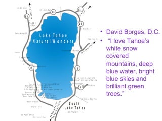
- 1. • David Borges, D.C. • “I love Tahoe’s white snow covered mountains, deep blue water, bright blue skies and brilliant green trees.” E a g le R o c k . F r o g R o c k 3 1 . F a n n y B r id g e 3 5 . 3 4 . B ig C h ie f 3 3 . L ib e r t y B e ll S h a k e s p e a r e ’s R o c k 3 0 . 2 5 . L in e u p E a s t P e a k 2 4 . 7 7 a n d 1 1 2 3 . L in c o ln ’s F a c e 2 2 . P y r a m id P e a k . S o u t h L a k e T a h o e ToSacramento ToSanFrancisco ToTruckee T o R e n o T o C a r s o n C ity T a h o e C i t y 8 98 9 8 9 2 8 2 8 4 3 1 5 0 2 0 7 L a k e T a h o e N a t u r a l W o n d e r s 1 . B a r k e r P e a k 2 . R a b b it P e a k 3 . T w in P e a k s 4 . N a p o le o n ’s H a t F r o g R o c k 5 . B a b y C h ic k R o c k 6 . 7 . F o u r L o a v e s o f B r e a d 8 . G la d ia to r O ld K in g C o le 9 . 1 0 . S t o n e S e a l O ld e r M a n P r o f ile 1 1 . 1 2 . M a n L o o k in g T o w a r d S k y O w l 1 3 . B a la n c in g R o c k 1 4 . G o r illa P r o file 1 7 . I n d ia n P r o f ile 1 8 . M o u n t T a lla c 2 0 . A n g o r a C a t 2 1 . 2 7 . R o u n d H ill 2 6 . C a s tle R o c k 2 8 . C a v e R o c k - L a d y o f t h e L a k e 2 9 . C a v e R o c k - G o r illa P r o f ile 3 2 . B e a r C la w 1 5 F a n n e t te I s la n d 1 6 . E m e r a ld B a y S lid e 1 9 . M a g g ie ’s P e a k ( s )
- 2. David Borges, D.C.David Borges, D.C. • Family moved to South Lake Tahoe in May 1965 at age 12Family moved to South Lake Tahoe in May 1965 at age 12 • Parents, Sam and Rosie Borges started Sleigh Ride businessParents, Sam and Rosie Borges started Sleigh Ride business in 1967 telling Tahoe storiesin 1967 telling Tahoe stories • Tahoe Valley Elementary School; South Tahoe IntermediateTahoe Valley Elementary School; South Tahoe Intermediate (now Middle School) School; Graduated STHS 1972(now Middle School) School; Graduated STHS 1972 • Under grad 5 years concluded at Pacific University, ForestUnder grad 5 years concluded at Pacific University, Forest Grove OR. 1977Grove OR. 1977 • Western States Chiropractic College grad 1980Western States Chiropractic College grad 1980 • Taught at Life Chiropractic College-West 1981 to 1984Taught at Life Chiropractic College-West 1981 to 1984 • Started South Lake Tahoe Chiropractic practice 1985Started South Lake Tahoe Chiropractic practice 1985 • Started giving Tahoe history lectures for Elementary SchoolsStarted giving Tahoe history lectures for Elementary Schools and service organizations in 1986. Involved with Lake Tahoeand service organizations in 1986. Involved with Lake Tahoe Historical SocietyHistorical Society • Started teaching at Lake Tahoe Community College Fall 2006Started teaching at Lake Tahoe Community College Fall 2006
- 3. Tahoe is theTahoe is the “jewel”“jewel” between thebetween the silver andsilver and gold states.gold states. Perfectly setPerfectly set high in thehigh in the SierraSierra NevadaNevada (snow(snow capped)capped) rangerange.
- 4. You know you’reYou know you’re a Tahoe Local if:a Tahoe Local if: You know Carson Pass is in Alpine County, Carson Lake is in Churchill county, Carson City is in Eagle Valley, and Minden and Gardnerville are in Carson Valley.
- 5. You know you’reYou know you’re a Tahoe Local if:a Tahoe Local if: You know Placerville is in El Dorado County and Nevada City is in Placer County and Nevada City was named in 1850 before the State of Nevada in 1864.
- 6. Tahoe HistoryTahoe History • class experience.class experience. • Each class starts on time, ends on time and weEach class starts on time, ends on time and we have a great time.have a great time. • At 6:00 pm class starts, 5 minute break at 6:45,At 6:00 pm class starts, 5 minute break at 6:45, ends 7:30 pm.ends 7:30 pm. • Lyn LandauerLyn Landauer The Mountain SeaThe Mountain Sea ChapterChapter review. Dated reading assignments are in thereview. Dated reading assignments are in the class syllabus.class syllabus. • ““Tahoeology” the whimsical study of Tahoe’sTahoeology” the whimsical study of Tahoe’s people, places and things.people, places and things.
- 7. Further Tahoe UnderstandingFurther Tahoe Understanding • It is from studying the past that we gain insight for theIt is from studying the past that we gain insight for the future.future. • This class is designed to enhance your personal TahoeThis class is designed to enhance your personal Tahoe experience by becoming more aware of what is alreadyexperience by becoming more aware of what is already around us.around us. • Lake Tahoe Historical SocietyLake Tahoe Historical Society PO Box 404 South LakePO Box 404 South Lake Tahoe CA 96156 (530) 541-5458. $25 individual, $40Tahoe CA 96156 (530) 541-5458. $25 individual, $40 Family, $65 Business, $300 Life membership.Family, $65 Business, $300 Life membership. • You will get to see what the tourists see and understandYou will get to see what the tourists see and understand historical perspective.historical perspective. • If, at any time, you feel this class should get in moreIf, at any time, you feel this class should get in more depth in any Tahoe subject let me know so I can improvedepth in any Tahoe subject let me know so I can improve the class now and for future students.the class now and for future students.
- 8. Class One –Class One – Mountains,Mountains, NativeNative AmericansAmericans • 1: How the Lake Was1: How the Lake Was FormedFormed • Chapter 2: NativeChapter 2: Native Americans in the TahoeAmericans in the Tahoe areaarea
- 9. You know you’reYou know you’re a Tahoe Local if:a Tahoe Local if: If you haveIf you have switched fromswitched from heat to A/C andheat to A/C and back in theback in the same day.same day. If you realizeIf you realize that you shouldthat you should have had yourhave had your firewoodfirewood stacked by thestacked by the time thetime the KokaneeKokanee Salmon start toSalmon start to spawn inspawn in October.October.
- 10. Chapter 1: How Was TahoeChapter 1: How Was Tahoe Formed?Formed? • Genesis 1:1 In the beginning, God createdGenesis 1:1 In the beginning, God created the heavens and the earth.the heavens and the earth. • God did an especially great job in theGod did an especially great job in the Tahoe region.Tahoe region. • This hour we will discuss how Lake TahoeThis hour we will discuss how Lake Tahoe was not formed by the collapse of awas not formed by the collapse of a volcanic crater, the Basin was actuallyvolcanic crater, the Basin was actually formed by the rise and fall of the shifting offormed by the rise and fall of the shifting of the geologic faults, volcanic action andthe geologic faults, volcanic action and glaciers.glaciers.
- 11. Tahoe’s Geological Formation –Tahoe’s Geological Formation – Approximate NumbersApproximate Numbers Landauer • 200 million years ago the Pacific Tectonic Plate pushed east200 million years ago the Pacific Tectonic Plate pushed east against the North American plate diving beneath…Subductionagainst the North American plate diving beneath…Subduction • 75 million years ago the final up-thrust. Fault lines exist 7 miles75 million years ago the final up-thrust. Fault lines exist 7 miles deep beneath the base of the Carson Range.deep beneath the base of the Carson Range. • 65 million years ago volcanic activity and the emergence of65 million years ago volcanic activity and the emergence of mammals.mammals. • Mt. Pluto (North Star Ski Resort) volcano lava flow created aMt. Pluto (North Star Ski Resort) volcano lava flow created a lateral ridge at the northern end of the valley blocking waterlateral ridge at the northern end of the valley blocking water from escaping.from escaping. • 3 million years ago temperatures dropped in North America3 million years ago temperatures dropped in North America creating glaciers.creating glaciers. • 1 million years ago earth's atmosphere began to warm leaving1 million years ago earth's atmosphere began to warm leaving terminal and lateral moraines. Fallen Leaf Lake, Cascade Lake,terminal and lateral moraines. Fallen Leaf Lake, Cascade Lake, Emerald Bay and may others.Emerald Bay and may others. • Temp lowered again re-establishing smaller glaciers.Temp lowered again re-establishing smaller glaciers.
- 16. Geological Evidence • The continuity of mountain chains also provide evidence for Pangea. One example of this are the similar rocks of North American Appalachian Mountains chain which extends from the northeastern United States to same rocks of the Caledonides of Ireland, Britain, Greenland, and Scandinavia. As well as the similar rocks (magma) of North America and the rocks of Mauritandes in Western Africa. Appalachain - Caledonies Mauritandes chains
- 17. Fossil Evidence of Tectonic Plates
- 18. SierraNevada Farallon PlateSan Andreas Fault Farallon Plate Farallon Plate Convergent boundaries Transform boundaries Divergent boundaries approx 3 cm /year Convergent boundaries Pacific Plate
- 19. 1906 Earthquake change of ground slippage in feet
- 20. Missouri River Sierra Nevada gold mines History is all explained by geography. - Robert Penn Warren Hard Road WestHard Road West Keith MeldahlKeith Meldahl Keith Meldahl Physical Sciences Department Mira Costa College
- 21. 250 Million Years Ago – Tectonic250 Million Years Ago – Tectonic Plate MovementPlate Movement North American Plate Sea level 4,500 feet elevation Sierra Nevada growth - 11,000 feet elevation West East Farallon Tectonic is Plate subducting the North American Plate Farallon Tectonic Plate Coastal Range 500 to 2500 feet Sacramento Carson City SF Pacific Tectonic Plate moving north
- 23. 2 million to 65 Million Years Ago Volcanic Activity
- 24. 3 Million Years Ago Glaciers
- 25. How the Lake Tahoe Basin WasHow the Lake Tahoe Basin Was FormedFormed Sierra Nevada- Crystal Range Sierra Nevada -Carson Range Tahoe Graben
- 26. Whose Fault Was it?Whose Fault Was it? • The Lake Tahoe Basin was formed by geologicThe Lake Tahoe Basin was formed by geologic block (normal) dip slip faulting. A geologic blockblock (normal) dip slip faulting. A geologic block dip-slip fault is a fracture in the earth's crustdip-slip fault is a fracture in the earth's crust causing blocks of land to move up or down.causing blocks of land to move up or down. • Uplifted blocks created the Sierra Nevada –Uplifted blocks created the Sierra Nevada – Crystal Range on the west and the SierraCrystal Range on the west and the Sierra Nevada - Carson Range on the east.Nevada - Carson Range on the east. • The down-dropped block (graben) created theThe down-dropped block (graben) created the Lake Tahoe Basin in between.Lake Tahoe Basin in between.
- 27. ““Living with Faults”Living with Faults” Mark McLaughlinMark McLaughlin • The Sierra is actually enormous blocks of graniteThe Sierra is actually enormous blocks of granite tilted toward the Pacific Ocean, which produce a 35-tilted toward the Pacific Ocean, which produce a 35- mile gradual slope on the west, and a steep, 10-milemile gradual slope on the west, and a steep, 10-mile descent on the east.descent on the east. • The westward tilt of the large fault blocks in theThe westward tilt of the large fault blocks in the Sierra uplift generated towering walls of graniteSierra uplift generated towering walls of granite along its eastern edge which today represent thealong its eastern edge which today represent the highest peaks in the Tahoe Basin, such as Freelhighest peaks in the Tahoe Basin, such as Freel Peak (10,881’), Pyramid Peak (9,983’) in DesolationPeak (10,881’), Pyramid Peak (9,983’) in Desolation Wilderness), and Mt. Tallac (9,735’).Wilderness), and Mt. Tallac (9,735’).
- 28. . T o R e n o T o C a r s o n C ity 8 98 9 8 9 2 8 2 8 4 3 1 5 0 2 0 7 L a k e T a h o e North Tahoe – Incline Village fault West Tahoe - Dollar Point fault Tahoe-Sierra frontal fault Carson Range fault
- 29. Is There Any Evidence of aIs There Any Evidence of a Tsunami in Tahoe?Tsunami in Tahoe? • Schweickert have foundSchweickert have found evidence of underwaterevidence of underwater landslides and tsunamislandslides and tsunamis in the Lake Tahoein the Lake Tahoe Basin. ComputerBasin. Computer modeling shows thatmodeling shows that magnitude 7magnitude 7 earthquakes onearthquakes on submerged faults couldsubmerged faults could generate tsunamis.generate tsunamis.
- 30. Tahoe TsunamiTahoe Tsunami • 7,000 to 15,000 years ago a Tsunami-generated7,000 to 15,000 years ago a Tsunami-generated boulder ridge in Lake Tahoe, California-Nevadaboulder ridge in Lake Tahoe, California-Nevada was discovered,"was discovered," GeologyGeology November 2006, aNovember 2006, a journal of the Geological Society of America.journal of the Geological Society of America. • In Tahoe’s northwest shore, several cubic milesIn Tahoe’s northwest shore, several cubic miles of boulders and soil plunged more than 1,500of boulders and soil plunged more than 1,500 feet to the lake bottom.feet to the lake bottom.
- 31. Tahoe’s northwest shoreTahoe’s northwest shore 7,000 to 15,000 years ago, a massive underwater landslide on the West Tahoe - Dollar Point fault triggered a tsunami that hit Tahoe’s East shore. Tahoe City- Dollar Point McKinney Bay
- 33. . T o R e n o T o C a r s o n C ity 8 98 9 8 9 2 8 2 8 4 3 1 5 0 2 0 7 L a k e T a h o e West Tahoe - Dollar Point fault Tsunami Wave 7 to 15 million years ago
- 34. . T o R e n o T o C a r s o n C ity 8 98 9 8 9 2 8 2 8 4 3 1 5 0 2 0 7 L a k e T a h o e North Tahoe – Incline Village fault Mt Rose Tsunami Wave Barton Hospital is 8 feet above Tahoe’s high shore lineBarton Hospital is 8 feet above Tahoe’s high shore line Next predicted Tsunami
- 35. What was the Estimated Richter MagnitudeWhat was the Estimated Richter Magnitude for the 1906 San Francisco Earthquake?for the 1906 San Francisco Earthquake?• Richter magnitudes increase logarithmically, meaning the energy increases 10 times for eachRichter magnitudes increase logarithmically, meaning the energy increases 10 times for each magnitude number. In 1979 Moment Magnitude Scale is the current successor to the Richtermagnitude number. In 1979 Moment Magnitude Scale is the current successor to the Richter Scale.Scale. Richter Magnitude Intensity DescriptionRichter Magnitude Intensity Description • 22 Usually not felt,Usually not felt, 3 F3 Felt by many indoors, dishes and doors disturbed,elt by many indoors, dishes and doors disturbed, 44 Felt by nearlyFelt by nearly everyone.everyone. 55 Felt by all. Furniture moves. Slight damage occurs,Felt by all. Furniture moves. Slight damage occurs, 66 Moderate to major damage.Moderate to major damage. Minor damage to chimneys and walls collapse,Minor damage to chimneys and walls collapse, 77 All buildings suffer major damage. GroundAll buildings suffer major damage. Ground cracks, pipes break, foundations shift. Structures destroyed. Ground is badly cracked.cracks, pipes break, foundations shift. Structures destroyed. Ground is badly cracked. Landslides occur.Landslides occur. • 7.8 intensity, duration 2.6 minutes and in one day more than7.8 intensity, duration 2.6 minutes and in one day more than half of the 400,000 population became homeless. “Outside ofhalf of the 400,000 population became homeless. “Outside of war the 4 day SF fire was bigger in any metropolitan fire inwar the 4 day SF fire was bigger in any metropolitan fire in history.”history.” Smith SF is Burning p Plumew 2006 pg 3. • 88 Almost all structures fall. Objects thrown into the air. All construction destroyed.Almost all structures fall. Objects thrown into the air. All construction destroyed. • 99 Devastating in areas several thousand miles across –Devastating in areas several thousand miles across – • The 2004 Indian Ocean Earthquake 9.2 Sumatra, Indonesia second largestThe 2004 Indian Ocean Earthquake 9.2 Sumatra, Indonesia second largest recorded in history Tsunami 100 feetrecorded in history Tsunami 100 feet (30 meters) high. Duration lasting between(30 meters) high. Duration lasting between 8.3 to 10 minutes.8.3 to 10 minutes. • Highest magnitude was the Great Chile Earthquake 9.5 May 22, 1960 localHighest magnitude was the Great Chile Earthquake 9.5 May 22, 1960 local Tsunami 75 feet high.Tsunami 75 feet high. • http://mistupid.com/geology/richter.htm
- 36. GrabenGraben • AA grabengraben is ais a depressed block ofdepressed block of land bordered byland bordered by parallel faults.parallel faults. • Horsts are parallelHorsts are parallel blocks aboveblocks above grabens.grabens. • "Graben" is the"Graben" is the German word forGerman word for "ditch“ or “grave”."ditch“ or “grave”. Carson Range Tahoe Basin Sierra Nevada Sacramento Valley Coastal Range Pacific Ocean
- 37. Lahonton -Lahonton - Pleistocene epochPleistocene epoch North American Plate Sea level Lahonton -4,500 feet elevation West East Farallon Tectonic Plate subducting the North American Plate Farallon Tectonic Plate Pacific Plate is moving north
- 38. Mark TwainMark Twain on the Greaton the Great BasinBasin Half a dozen littleHalf a dozen little mountain brooks flowmountain brooks flow into Mono Lake, butinto Mono Lake, but not a stream of anynot a stream of any kind flows out of it. Itkind flows out of it. It neither rises nor falls,neither rises nor falls, apparently, and what itapparently, and what it does with its surplusdoes with its surplus water is a dark andwater is a dark and bloody mystery.bloody mystery.
- 39. 300 miles long
- 40. GREAT BASIN Origin of the Basin & Range ProvinceOrigin of the Basin & Range Province and the Great Basinand the Great Basin
- 41. • Ancient Lake Lahontan that existed during the ice age, covering much of northwestern Nevada, extending into northeastern California and southern Oregon. At its peak approximately 12,700 years ago, the lake had a surface area of over 8500 square miles.
- 42. WorldWorld Endorheic basinsEndorheic basins • From the Greek: νδον,ἔ éndon, "within" and ε ν,ῥ ῖ rheîn, "to flow"; also terminal or closed basin) is a closed drainage basin that retains water and allows no outflow to other bodies of water such as rivers or oceans. Frémont is credited with determining the Great Basin as endorheic http://www.astrotheme.com/portraits/kmKyV7E534wm.htm
- 43. Where Does Tahoe Water Stop?Where Does Tahoe Water Stop? 104 miles long
- 44. The Great Basin “the Big Graben”The Great Basin “the Big Graben” and the Weatherand the Weather • The Great BasinThe Great Basin is a large, arid region of the westernis a large, arid region of the western United States, commonly defined as the contiguousUnited States, commonly defined as the contiguous watershed region, roughly between the Rocky Mountainswatershed region, roughly between the Rocky Mountains and the Sierra Nevada, that has no natural outlet to theand the Sierra Nevada, that has no natural outlet to the sea.sea. • TheThe Great Basin DesertGreat Basin Desert is defined by the extent ofis defined by the extent of characteristic plant species, and covers a somewhatcharacteristic plant species, and covers a somewhat different area.different area. • TheThe Great Basin Culture AreaGreat Basin Culture Area, home to the Great, home to the Great Basin Indian tribes also extends further to the north andBasin Indian tribes also extends further to the north and east than the hydrographic basin. Paiute and Washoe.east than the hydrographic basin. Paiute and Washoe.
- 45. Rain (precipitation) Shadow?Rain (precipitation) Shadow? • A rain shadow (or more accurately,A rain shadow (or more accurately, precipitationprecipitation shadowshadow) is a dry region on the surface of the Earth) is a dry region on the surface of the Earth that isthat is leewardleeward or behind a mountain with respect toor behind a mountain with respect to the prevailing wind direction.the prevailing wind direction. • **A rain shadow area is dry because, as moist airA rain shadow area is dry because, as moist air masses rise to top a mountain range or largemasses rise to top a mountain range or large mountain, the air cools and water vapor condensesmountain, the air cools and water vapor condenses as rain or snow, falling on theas rain or snow, falling on the windward sidewindward side oror toptop of the mountain.of the mountain. • This process is calledThis process is called orographic precipitationorographic precipitation.. (Related to, or caused by, physical geography ('o`ros,(Related to, or caused by, physical geography ('o`ros, a mountain + -graphy ).a mountain + -graphy ).
- 46. Rain (precipitation) Shadow?Rain (precipitation) Shadow? • The Death Valley is behind both the Pacific CoastThe Death Valley is behind both the Pacific Coast Ranges of California and the Sierra Nevada, and isRanges of California and the Sierra Nevada, and is one of the driest places on the planet.one of the driest places on the planet. • Hawaii also has rain shadows, with some areas ofHawaii also has rain shadows, with some areas of the islands being desert.the islands being desert. • Chile’s Atacama Desert the most arid place in theChile’s Atacama Desert the most arid place in the world with mountains 22,590 feet on the windwardworld with mountains 22,590 feet on the windward side. The average rainfall is 1 mm per year, and atside. The average rainfall is 1 mm per year, and at one time no rain fell for 400 years. Some weatherone time no rain fell for 400 years. Some weather stations never received rain.stations never received rain.
- 47. Windward side vs Leeward sideWindward side vs Leeward side Orographic precipitation Wet side!! Arid land West East Windward side Prevailing wind direction Leeward sideAverage Rainfall Sacramento Placerville Reno 17.4 inches 38.3 inches 7.5 inches
- 48. The Great Basin region Orographic Rain Shadow • http://en.wikipedia.org/wiki/Basin_ and_Range Windward Wet Leeward Dry West East Prevailing winds
- 49. 2 Million to 65 Million Years Ago Volcanic Activity
- 50. The Tahoe Basin is SealedThe Tahoe Basin is Sealed • About 2 million years ago, lava flowingAbout 2 million years ago, lava flowing from north shore's Mt. Pluto (the mountainfrom north shore's Mt. Pluto (the mountain is now known as the Northstar Ski Resort)is now known as the Northstar Ski Resort) formed a barrier across the basin'sformed a barrier across the basin's northeastern outlet.northeastern outlet. • Water from rivers and streams then filledWater from rivers and streams then filled the Lake Tahoe Basin over 600 feetthe Lake Tahoe Basin over 600 feet higher than its present level.higher than its present level.
- 51. . T o R e n o T o C a r s o n C ity 8 98 9 8 9 2 8 2 8 4 3 1 5 0 2 0 7 L a k e T a h o e Mt Pluto
- 52. Mt Pluto
- 53. Krakatoa Volcano 1883Krakatoa Volcano 1883 • Light colored magma plugged the dark colored magma.Light colored magma plugged the dark colored magma. • The explosions were heard on Rodriguez Island, 2800 milesThe explosions were heard on Rodriguez Island, 2800 miles (4653 km) distant across the Indian Ocean.(4653 km) distant across the Indian Ocean. • Three months after the eruption ash products had spread toThree months after the eruption ash products had spread to higher latitudes causing such vivid purple sunset. Unusualhigher latitudes causing such vivid purple sunset. Unusual sunsets continued for 3 years. Lowered Earth’s temp 2sunsets continued for 3 years. Lowered Earth’s temp 2 degrees for a few years. Theory: the ash in the air caused adegrees for a few years. Theory: the ash in the air caused a reflective field around the planet and the Sun’s rays werereflective field around the planet and the Sun’s rays were reflected away from earth.reflected away from earth. • The blast had the power of 100 megatons (million tons) of TNT.The blast had the power of 100 megatons (million tons) of TNT. Hiroshima atomic bomb 20 kilotons (thousand tons)Hiroshima atomic bomb 20 kilotons (thousand tons) • Ash fell on Singapore 500 miles (840 km) to the NorthAsh fell on Singapore 500 miles (840 km) to the North • The tsunami generated by theThe tsunami generated by the 1883 eruption of Krakatoa,1883 eruption of Krakatoa, IndonesiaIndonesia. The wave reached heights of 40 meters (140 feet). The wave reached heights of 40 meters (140 feet) above sea level.above sea level.
- 54. 3 Million Years Ago Glaciers
- 55. Rivers of IceRivers of Ice • A Daily GrindA Daily Grind during the last Ice Age,during the last Ice Age, huge glaciers grew in the surroundinghuge glaciers grew in the surrounding mountains. The broad U-shaped valleys ofmountains. The broad U-shaped valleys of Emerald Bay, Fallen Leaf Lake andEmerald Bay, Fallen Leaf Lake and Cascade Lake were carved by these riversCascade Lake were carved by these rivers of ice.of ice.
- 56. MoraineMoraine • (mo rān´), a formation composed of(mo rān´), a formation composed of unsorted and unbedded rock and soilunsorted and unbedded rock and soil debris called till, which was deposited by adebris called till, which was deposited by a glacier. The till that falls on the sides of aglacier. The till that falls on the sides of a valley glacier from the bounding cliffsvalley glacier from the bounding cliffs makes up lateral moraines, runningmakes up lateral moraines, running parallel to the valley sides.parallel to the valley sides.
- 57. Geological RemnantsGeological Remnants • Hot springs - natural geothermal activityHot springs - natural geothermal activity • North Shore Lake Tahoe - Brockway SpringsNorth Shore Lake Tahoe - Brockway Springs • Grover's, Markleeville - Used by John C. FremontGrover's, Markleeville - Used by John C. Fremont in 1844.in 1844. • Carson City Hot Springs, by the Carson CityCarson City Hot Springs, by the Carson City Airport – 1849Airport – 1849 • David Wally’s, Genoa 1862David Wally’s, Genoa 1862 • Steamboat, South Reno on highway 395Steamboat, South Reno on highway 395 • University of Nevada Reno is using theirUniversity of Nevada Reno is using their geothermal resources to be energy selfgeothermal resources to be energy self sustaining.sustaining. “Behold a steamboat in the desert” – Mark Twain 1861
- 58. Tahoe TreesTahoe Trees 1.1. Sugar Pine ( Pinus Lambertiana) – most prized in the basin –Sugar Pine ( Pinus Lambertiana) – most prized in the basin – was used for building because of its clear lumber.was used for building because of its clear lumber. 2.2. Incense Cedar (Calocedrus decurrens) – Federally protectedIncense Cedar (Calocedrus decurrens) – Federally protected – was used for ground contact and shingles because of the– was used for ground contact and shingles because of the resistance to decay.resistance to decay. 3.3. Jeffery Pine (Pinus Jeffrey) - used for general purposes. IfJeffery Pine (Pinus Jeffrey) - used for general purposes. If alive preserve (Cousin to the lower elevation Ponderosa Pine.alive preserve (Cousin to the lower elevation Ponderosa Pine. Slight differences and both are called Yellow Pines.) ConesSlight differences and both are called Yellow Pines.) Cones differences - gentle Jeffery, prickly Ponderosa.differences - gentle Jeffery, prickly Ponderosa. 4.4. Lodgepole Pine (Pinus contorta) – used for tee-pee polesLodgepole Pine (Pinus contorta) – used for tee-pee poles straight. (Sometimes mistakenly named Tamarack by locals.straight. (Sometimes mistakenly named Tamarack by locals. Tamarack is actually only found on the East Coast.)Tamarack is actually only found on the East Coast.) 5.5. White-Fir/ Red-Fir - used for firewoodWhite-Fir/ Red-Fir - used for firewood 6.6. Douglas Fir - used for strengthDouglas Fir - used for strength 7.7. Quaking AspenQuaking Aspen Sessions S. Wheeler Tahoe Heritage the Bliss Family of Glenbrook, Nevada University of Nevada Press1992 page 28
- 59. Ranger Randy needle bundle countRanger Randy needle bundle count and tree identificationand tree identification • 1 – one needle makes an “I” = Fir1 – one needle makes an “I” = Fir • 2 – two needles makes a “L” = Lodgepole2 – two needles makes a “L” = Lodgepole • 3 – three needles makes an “Y” = Yellow Pine3 – three needles makes an “Y” = Yellow Pine (Jeffery and Ponderosa)(Jeffery and Ponderosa) • 4 – no trees with bundle of four4 – no trees with bundle of four • 5 – (-1) four needles makes a “W” = White pine5 – (-1) four needles makes a “W” = White pine (white bark) – Sugar Pine(white bark) – Sugar Pine
- 60. One Minute ReviewOne Minute Review • What was the most useful or meaningfulWhat was the most useful or meaningful thing you learned during this session?thing you learned during this session? • What question(s) remain upper-most inWhat question(s) remain upper-most in your mind as we end this session?your mind as we end this session?
- 61. Week #1 hour 1 summaryWeek #1 hour 1 summary • Hour 1 How Tahoe wasHour 1 How Tahoe was formedformed • Next hour #2. • Hour 2 Ancient peopleHour 2 Ancient people
- 62. Tahoe Basin = Water Shed LandTahoe Basin = Water Shed Land Area and Lake Tahoe Surface AreaArea and Lake Tahoe Surface Area • Tahoe Basin = 500Tahoe Basin = 500 square milessquare miles (506)(506) • Land portion = 300Land portion = 300 square milessquare miles (314)(314) • Water portion = 200Water portion = 200 square milessquare miles (192)(192)
- 63. Does Tahoe Ever Freeze?Does Tahoe Ever Freeze? • No, because the lake water is always inNo, because the lake water is always in motion. Each winter the cold water on themotion. Each winter the cold water on the surface sinks while warm water rises fromsurface sinks while warm water rises from the deep.the deep. • This mixing motion keeps the lake fromThis mixing motion keeps the lake from freezing over, though Emerald Bay will onfreezing over, though Emerald Bay will on occasion freeze.occasion freeze.
- 65. How Cold is Tahoe Water?How Cold is Tahoe Water? • The surface water in Lake Tahoe rangesThe surface water in Lake Tahoe ranges from 41 to 68 degrees Fahrenheit,from 41 to 68 degrees Fahrenheit, depending the season.depending the season. • At 600 feet below the surface theAt 600 feet below the surface the temperature stays a constant 39 degreestemperature stays a constant 39 degrees Fahrenheit.Fahrenheit.
- 66. The First PeopleThe First People • The Washoe tribe of Nevada andThe Washoe tribe of Nevada and California will tell you that it cannot be saidCalifornia will tell you that it cannot be said when the first people came to the lake, aswhen the first people came to the lake, as the Washoe have always been at Tahoe.the Washoe have always been at Tahoe. • http://www.fs.fed.us/r5/ltbmu/documents/faqs/index
- 67. **What were the Names of the FourWhat were the Names of the Four Indian Tribes that Lived or TradedIndian Tribes that Lived or Traded in the Lake Tahoe Basin?in the Lake Tahoe Basin? Paiute-Paiute- NevadaNevada Pyramid LakePyramid Lake Nisenan Maidu-Nisenan Maidu- California Sierra foothills –California Sierra foothills – Miwok-Miwok- California Coast to SierraCalifornia Coast to Sierra foothills – El Dorado Hills Casinofoothills – El Dorado Hills Casino Lyndall Laundauer, Ph.D. “The Mountain Sea” 1996 Flying Cloud Press pg 9 WashoeWashoe – (may have– (may have descended from Martis) Easterndescended from Martis) Eastern Sierra and Great BasinSierra and Great Basin
- 69. Piute Paiute Chief Truckee - Murphy Townsend Stevens Party. Son - Chief Winnemucca – leader of the 1860 Pyramid Lake War Granddaughter Sarah Winnemucca - writer historian California Nisenan
- 71. PaiutePaiute • Chief Truckee helped Walker party in 1833,Chief Truckee helped Walker party in 1833, Military Fremont in 1844, private StevensMilitary Fremont in 1844, private Stevens party later in 1844 and many others toparty later in 1844 and many others to cross the Sierra. Helped in the Mexicancross the Sierra. Helped in the Mexican War 1846.War 1846. • Chief Winnemucca – (Truckee’s son)Chief Winnemucca – (Truckee’s son) Paiute War of 1860. 76 of the 105 USPaiute War of 1860. 76 of the 105 US militiamen were killed. Numagamilitiamen were killed. Numaga (Winnemucca’s Nephew) also fought.(Winnemucca’s Nephew) also fought. • Sarah Winnemucca: (Winnemucca’sSarah Winnemucca: (Winnemucca’s daughter) became an author.daughter) became an author. ChiefChief WinnemuccaWinnemucca -1882-1882 SarahSarah WinnemuccaWinnemucca 1842 -18911842 -1891 Chief TruckeeChief Truckee - 1859- 1859
- 72. Why was Fort Churchill built?Why was Fort Churchill built? It was built to protect emigrants and local settlers from theIt was built to protect emigrants and local settlers from the 1860 Paiute attacks.1860 Paiute attacks. Fort Churchill as occupied by US soldiers after the Paiute WarFort Churchill as occupied by US soldiers after the Paiute War from July 1860 through 1869 to patrol and keep the Emigrantfrom July 1860 through 1869 to patrol and keep the Emigrant trial open.trial open. The silver and gold mining increased white settlement, whichThe silver and gold mining increased white settlement, which resulted conflicts. Silver in Virginia City 1859, Pony Expressresulted conflicts. Silver in Virginia City 1859, Pony Express 1860 to 1861, Telegraph 1861, Civil War 1861 to 1865,1860 to 1861, Telegraph 1861, Civil War 1861 to 1865, Transcontinental Railroad 1869.Transcontinental Railroad 1869.
- 73. Fort Churchill
- 74. Tahoe Native Trade DevelopmentTahoe Native Trade Development • Many of the roads we use today to travel in theMany of the roads we use today to travel in the mountains and foothills of the Sierra were first usedmountains and foothills of the Sierra were first used by Washoe and Maidu people.by Washoe and Maidu people. • They traveled to and from their winter and summerThey traveled to and from their winter and summer camps, and they traveled between summer camps ofcamps, and they traveled between summer camps of neighboring tribes.neighboring tribes. • Evidence – obsidian for arrow heads were found inEvidence – obsidian for arrow heads were found in the Western Sierras near Wright’s Lake where therethe Western Sierras near Wright’s Lake where there is no obsidian. (6 miles north of Kyburz). Obsidianis no obsidian. (6 miles north of Kyburz). Obsidian rocks from each volcano produces a distinguishablerocks from each volcano produces a distinguishable type of obsidian, making it possible fortype of obsidian, making it possible for archaeologists to trace the origins of a particulararchaeologists to trace the origins of a particular artifact.artifact. • Conclusion - the obsidian was brought to WesternConclusion - the obsidian was brought to Western Sierra Nisenan Miadu by the Eastern Sierra Washoe.Sierra Nisenan Miadu by the Eastern Sierra Washoe.
- 75. • This map shows the general overlap in territory between the Washoe (white) to the east and the Maidu (red) to the west. Tahoe Every summer forEvery summer for hundreds of years,hundreds of years, Maidu (from theMaidu (from the western Sierra footwestern Sierra foot hills) and Washoehills) and Washoe peoples came to thepeoples came to the higher elevation (fromhigher elevation (from the eastern Sierrathe eastern Sierra foothills).foothills). Some items gatheredSome items gathered locally were traded forlocally were traded for items from other areas.items from other areas. They quickly becameThey quickly became very sophisticated invery sophisticated in bargaining.bargaining.
- 76. Example of aExample of a PetroglyphPetroglyph • Bedrock mortars orBedrock mortars or grinding rocks weregrinding rocks were used to grind.used to grind. • Summer camp sitesSummer camp sites have fragments ofhave fragments of rock used to makerock used to make scrapers,scrapers, arrowheads,arrowheads, hammers and otherhammers and other items.items. • This is a photo of aThis is a photo of a petroglyph found nearpetroglyph found near Donner Pass.Donner Pass.
- 78. The Court of AntiquityThe Court of Antiquity • This rock art site is on theThis rock art site is on the edge of Interstate 80, justedge of Interstate 80, just minutes from downtownminutes from downtown Reno. Some rock art isReno. Some rock art is located on those verticallocated on those vertical surfaces but most are foundsurfaces but most are found on the horizontal bedrock thaton the horizontal bedrock that looks out over the Truckeelooks out over the Truckee River.River.
- 79. The LagomarsinoThe Lagomarsino Rock Art SiteRock Art Site • The Lagomarsino Rock Art SiteThe Lagomarsino Rock Art Site is roughly 12 miles north ofis roughly 12 miles north of Virginia City. It consists of moreVirginia City. It consists of more than 2,000 panels of rock artthan 2,000 panels of rock art scattered over 1/4 mile on ascattered over 1/4 mile on a south facing rim rock and thesouth facing rim rock and the talus slope below. There istalus slope below. There is abundant ground stone amongabundant ground stone among the rock art and a largethe rock art and a large habitation feature across thehabitation feature across the wash. The rock art is primarilywash. The rock art is primarily non-representational but therenon-representational but there are a small number of animalare a small number of animal (including 2 big horn sheep) and(including 2 big horn sheep) and human motifs as wellhuman motifs as well
- 81. Pyramid Lake –Pyramid Lake – Tahoe water terminus North/East RenoTahoe water terminus North/East Reno • The petroglyphs found on limestone boulders nearThe petroglyphs found on limestone boulders near Pyramid Lake in northern Nevada’s high desert arePyramid Lake in northern Nevada’s high desert are similar in design to etchings found at a lake insimilar in design to etchings found at a lake in Oregon that are believed to be at least 7,600 yearsOregon that are believed to be at least 7,600 years oldold • Whether they turn out to be as old as 14,800 yearsWhether they turn out to be as old as 14,800 years ago or as recent as 10,500 years ago, they are stillago or as recent as 10,500 years ago, they are still the oldest petroglyphs that have been dated in Norththe oldest petroglyphs that have been dated in North America,” said Benson, a former research scientistAmerica,” said Benson, a former research scientist for the U.S. Geological Survey and current curator offor the U.S. Geological Survey and current curator of anthropology at the University of Colorado Naturalanthropology at the University of Colorado Natural History Museum in Boulder.History Museum in Boulder. • http://www.laketahoenews.net/2013/08/n-americas-oldest-petroglyphs-found-in-nev/? utm_source=feedburner&utm_medium=email&utm_campaign=Feed%3A+LakeTahoeNews+ %28Lake+Tahoe+News%29&utm_content=Yahoo%21+Mail
- 82. Landauer’s VocabularyLandauer’s Vocabulary • These roaming families were not the firstThese roaming families were not the first to come over the land bridge to theto come over the land bridge to the Western Hemisphere from Asia but wereWestern Hemisphere from Asia but were among the native groups that dispersedamong the native groups that dispersed through thethrough the salubrioussalubrious (se(se lōōlōō brē es)brē es) land at the western edge of the continent.land at the western edge of the continent. page 7page 7 • Answer: “To promote health or favorableAnswer: “To promote health or favorable to health.”to health.”
- 83. Ancient PeopleAncient People • Indian artifacts found in Squaw Valley andIndian artifacts found in Squaw Valley and Donner area have been dated 8,000 years ago.Donner area have been dated 8,000 years ago. Landauer pg 7 • The earliest people have been identified asThe earliest people have been identified as belonging to Hokan (Washoe) and Penutianbelonging to Hokan (Washoe) and Penutian (Maidu and Miwok) language. Shoshone or Uto-(Maidu and Miwok) language. Shoshone or Uto- Azetecan (Paiute) languageAzetecan (Paiute) language. Landauer pg 8
- 84. Washoe Tribe
- 89. Ancient PeopleAncient People Known Washoe sites areKnown Washoe sites are in King’s Beach andin King’s Beach and Tallac PointTallac Point. Landauer pg 11 Big Metate, WashoeBig Metate, Washoe Indians food grinder.Indians food grinder. Meeks Bay was known by the Washoe asMeeks Bay was known by the Washoe as magulu watah, one of a number of well-magulu watah, one of a number of well- established sites around Da-ow-a-ga.established sites around Da-ow-a-ga. Long time locals have stated small IndianLong time locals have stated small Indian summer camps were near the current Safewaysummer camps were near the current Safeway parking lot and Park Avenue / Stateline beachparking lot and Park Avenue / Stateline beach existed beforeexisted before WWIIWWII.. http://www.tahoecountry.com/oldtimetahoe/maguluwatah
- 93. **Physical Evidence of Indians in thePhysical Evidence of Indians in the South ShoreSouth Shore • Squaw Rock • Indian Baskets - room B103 • Tallac Site - Washoe Indian hut built by Scouts some summers
- 94. Which Was More Lethal to theWhich Was More Lethal to the California Native Indians - Guns orCalifornia Native Indians - Guns or Disease?Disease? • Before 1845 estimate was between 100,000 toBefore 1845 estimate was between 100,000 to 300,000 Native Indians.300,000 Native Indians. Landauer pg 13 • Disease – 1849 only 20,000 Native Indians left.Disease – 1849 only 20,000 Native Indians left. • 1900 few thousand native Indians in California1900 few thousand native Indians in California were able to maintain any aspect of their age-oldwere able to maintain any aspect of their age-old society.society. • 1919 Ishi was the last known “wild” Native Indian1919 Ishi was the last known “wild” Native Indian in California.in California. • Dat-So-La-Lee master Washoe Indian basketDat-So-La-Lee master Washoe Indian basket weaver in Tahoe 1900’sweaver in Tahoe 1900’s.. Landauer
- 95. California NativesCalifornia Natives • California Indians had a style of living builtCalifornia Indians had a style of living built around food gathering and fishing ratheraround food gathering and fishing rather than sowing, planting or harvesting.than sowing, planting or harvesting. • Called “Digger Indians” by the localsCalled “Digger Indians” by the locals.. • Resolved differences between tribesResolved differences between tribes peacefully.peacefully. • Landauer pg 15 Rolle/Graines The Golden State: A History of California 2nd ed Harlan Davidson Inc. 1979 Pg 13
- 96. IshiIshi • In August ofIn August of 1911, a “wild”1911, a “wild” Yana IndianYana Indian walked into awalked into a slaughterhouseslaughterhouse near Oroville,near Oroville, California, whereCalifornia, where he was turnedhe was turned over to the localover to the local sheriff.sheriff. http://www.thebicyclingguitarist.nethttp://www.thebicyclingguitarist.net /ishi/ishi
- 97. Ishi
- 98. Ishi –Ishi – Yana tribeYana tribe • A UC Berkeley AnthropologyA UC Berkeley Anthropology professor, Alfred L. Kroeber,professor, Alfred L. Kroeber, sent an associate, Thomassent an associate, Thomas T. Waterman, with a list ofT. Waterman, with a list of words (Rosetta Stone ofwords (Rosetta Stone of sorts) to communicate withsorts) to communicate with this last of the a "wild men"this last of the a "wild men" (Riffe and Roberts, 1992).(Riffe and Roberts, 1992). • The Bureau of Indian AffairsThe Bureau of Indian Affairs gave permission for Ishi togave permission for Ishi to go to the San Franciscogo to the San Francisco museum as a study. Ishi,museum as a study. Ishi, became a popular sensation.became a popular sensation. He lived several years at theHe lived several years at the museum, even working as amuseum, even working as a janitor there to earn his ownjanitor there to earn his own keep, before dying ofkeep, before dying of tuberculosis in 1916.tuberculosis in 1916. http://www.thebicyclingguitarist.net/ishihttp://www.thebicyclingguitarist.net/ishi//
- 99. Tahoe’sTahoe’s Washoe IndianWashoe Indian master basketmaster basket weaver - Dat Soweaver - Dat So La LeeLa Lee Landauer pg 16Landauer pg 16
- 100. One Minute ReviewOne Minute Review • What was the most useful or meaningfulWhat was the most useful or meaningful thing you learned during this session?thing you learned during this session? • What question(s) remain upper-most inWhat question(s) remain upper-most in your mind as we end this session?your mind as we end this session?
- 101. Piute Last Week We LearnedLast Week We Learned Week #1- Ancient Peoples, Tahoe Geology, Tahoe’s trees Week #2:Week #2: United States History prior to 1844 Emigrant Trail beginnings Chapter 3- John C. Fremont – 1844 Chapter 4 – Gold California and Tahoe Gold
Hinweis der Redaktion
- The next slide is regarding Krakatoa volcano