SlideShare ist ein Scribd-Unternehmen logo
1 von 2
Downloaden Sie, um offline zu lesen
Sensors and Their Specifications


Thematic Mapper (TM)
       A Thematic Mapper (TM) is one of the Earth observing sensors introduced
       in the Landsat program. The first was placed aboard Landsat
       4 (decommissioned in 2001), and another was operational aboard Landsat
       5 up to 2012. TM sensors feature seven bands of image data (three in
       visible wavelengths, four in infrared) most of which have 30 meter spatial
       resolution. TM is a whisk broom scanner which takes multi-spectral
       images across its ground track. It does not directly produce a thematic map.
       The Thematic Mapper has become a useful tool in the study of albedo and
       its relationship to global warming and climate change.


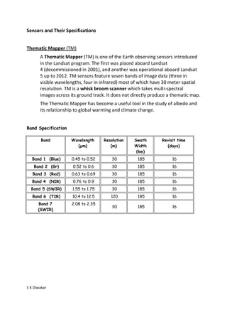
Band Specification

        Band         Wavelength      Resolution    Swath        Revisit time
                       (µm)             (m)        Width          (days)
                                                    (km)
   Band 1 (Blue)      0.45 to 0.52       30          185             16
    Band 2 (Gr)       0.52 to 0.6        30          185             16
   Band 3 (Red)       0.63 to 0.69       30          185             16
   Band 4 (NIR)       0.76 to 0.9        30          185             16
  Band 5 (SWIR)       1.55 to 1.75       30          185             16
   Band 6 (TIR)       10.4 to 12.5      120          185             16
      Band 7          2.08 to 2.35
                                         30          185             16
      (SWIR)


S K Diwakar
Sensors and Their Specifications


Enhanced Thematic Mapper (ETM+)

       ETM+ is similar to TM, but has a higher spatial resolution thermal channel
       and includes a new panchromatic channel. These satellites have a polar,
       circular, sun-synchronous 705-km orbit with a 16-day repeat cycle. The TM
       swath width is 185 km.

Band Specification


              Band             Wavelength Region (µm)        Resolution (m)

               1                   0.450-0.515 (blue)              30

               2                   0.525-0.605 (green)             30

               3                    0.630-0.690 (red)              30

               4                0.750-0.900 (near-IR)              30

               5                   1.55-1.75 (mid-IR)              30

               6                10.4-12.5 (thermal-IR)             60

               7                   2.08-2.35 (mid-IR)              30

              PAN                      0.52-0.90                   15


S K Diwakar

Weitere ähnliche Inhalte

Was ist angesagt?

Microwave remote sensing
Microwave remote sensingMicrowave remote sensing
Microwave remote sensingMohsin Siddique
 
A Brief Introduction to Remote Sensing Satellites
A Brief Introduction to Remote Sensing Satellites A Brief Introduction to Remote Sensing Satellites
A Brief Introduction to Remote Sensing Satellites Alireza Rahimzadeganasl
 
Introduction to Landsat
Introduction to LandsatIntroduction to Landsat
Introduction to LandsatNizam GIS
 
Basics of Remote Sensing
Basics of Remote SensingBasics of Remote Sensing
Basics of Remote SensingAkash Tikhe
 
Thermal Remote Sensing
Thermal Remote SensingThermal Remote Sensing
Thermal Remote SensingRohit Kumar
 
Presentation on the background theory of InSAR
Presentation on the background theory of InSARPresentation on the background theory of InSAR
Presentation on the background theory of InSARSERC at Carleton College
 
Lecture for landsat
Lecture for landsatLecture for landsat
Lecture for landsatGeoMedeelel
 
Emr intraction with atmosphere
Emr intraction with atmosphereEmr intraction with atmosphere
Emr intraction with atmosphereRahat Hasan
 
Commonly used ground truth equipments
Commonly used ground truth equipmentsCommonly used ground truth equipments
Commonly used ground truth equipmentsHimangshuKalita10
 
Intro to RS and GIS by mndp poonia
Intro to RS and GIS by mndp pooniaIntro to RS and GIS by mndp poonia
Intro to RS and GIS by mndp pooniamndp_slide
 
Intro to GIS and Remote Sensing
Intro to GIS and Remote SensingIntro to GIS and Remote Sensing
Intro to GIS and Remote SensingJohn Reiser
 
Band Combination of Landsat 8 Earth-observing Satellite Images
Band Combination of Landsat 8 Earth-observing Satellite ImagesBand Combination of Landsat 8 Earth-observing Satellite Images
Band Combination of Landsat 8 Earth-observing Satellite ImagesKabir Uddin
 

Was ist angesagt? (20)

Microwave remote sensing
Microwave remote sensingMicrowave remote sensing
Microwave remote sensing
 
A Brief Introduction to Remote Sensing Satellites
A Brief Introduction to Remote Sensing Satellites A Brief Introduction to Remote Sensing Satellites
A Brief Introduction to Remote Sensing Satellites
 
Ikonos
IkonosIkonos
Ikonos
 
Introduction to Landsat
Introduction to LandsatIntroduction to Landsat
Introduction to Landsat
 
Remote sensing
Remote sensingRemote sensing
Remote sensing
 
Microwave remote sensing
Microwave remote sensingMicrowave remote sensing
Microwave remote sensing
 
Basics of Remote Sensing
Basics of Remote SensingBasics of Remote Sensing
Basics of Remote Sensing
 
Thermal Remote Sensing
Thermal Remote SensingThermal Remote Sensing
Thermal Remote Sensing
 
Presentation on the background theory of InSAR
Presentation on the background theory of InSARPresentation on the background theory of InSAR
Presentation on the background theory of InSAR
 
MODIS
MODISMODIS
MODIS
 
Lecture for landsat
Lecture for landsatLecture for landsat
Lecture for landsat
 
Emr intraction with atmosphere
Emr intraction with atmosphereEmr intraction with atmosphere
Emr intraction with atmosphere
 
Band combinations (1)
Band combinations (1)Band combinations (1)
Band combinations (1)
 
Commonly used ground truth equipments
Commonly used ground truth equipmentsCommonly used ground truth equipments
Commonly used ground truth equipments
 
SPOT
SPOTSPOT
SPOT
 
Intro to RS and GIS by mndp poonia
Intro to RS and GIS by mndp pooniaIntro to RS and GIS by mndp poonia
Intro to RS and GIS by mndp poonia
 
Optical remote sensing
Optical remote sensingOptical remote sensing
Optical remote sensing
 
Intro to GIS and Remote Sensing
Intro to GIS and Remote SensingIntro to GIS and Remote Sensing
Intro to GIS and Remote Sensing
 
Band Combination of Landsat 8 Earth-observing Satellite Images
Band Combination of Landsat 8 Earth-observing Satellite ImagesBand Combination of Landsat 8 Earth-observing Satellite Images
Band Combination of Landsat 8 Earth-observing Satellite Images
 
Lecture 23 notes
Lecture 23   notesLecture 23   notes
Lecture 23 notes
 

Ähnlich wie Thematic mapper

1Resolutions of Remote Sensing1. Spatial (what area an.docx
1Resolutions of Remote Sensing1. Spatial (what area an.docx1Resolutions of Remote Sensing1. Spatial (what area an.docx
1Resolutions of Remote Sensing1. Spatial (what area an.docxaulasnilda
 
Platforms of Remote sensing and GIS
Platforms of Remote sensing and GISPlatforms of Remote sensing and GIS
Platforms of Remote sensing and GISMouna Guru
 
Remote sensing satellites with sensors
Remote sensing satellites with sensorsRemote sensing satellites with sensors
Remote sensing satellites with sensorsAnchit Garg
 
Lrm 111 intro remote sensing lesson iv
Lrm 111 intro remote sensing lesson ivLrm 111 intro remote sensing lesson iv
Lrm 111 intro remote sensing lesson ivmusadoto
 
nisizawa_IGARSS_HSRL_FR2.T07.ppt
nisizawa_IGARSS_HSRL_FR2.T07.pptnisizawa_IGARSS_HSRL_FR2.T07.ppt
nisizawa_IGARSS_HSRL_FR2.T07.pptgrssieee
 
Polarimetric Study of emission nebulea Stock 8 in Auriga
Polarimetric Study of emission nebulea Stock 8 in AurigaPolarimetric Study of emission nebulea Stock 8 in Auriga
Polarimetric Study of emission nebulea Stock 8 in Aurigarahulporuri
 
CROSS-COMPARISON BETWEEN CHINA HJ1A-CCD AND LANDSAT TM DATA(Guoqing Li).ppt
CROSS-COMPARISON BETWEEN CHINA HJ1A-CCD AND LANDSAT TM DATA(Guoqing Li).pptCROSS-COMPARISON BETWEEN CHINA HJ1A-CCD AND LANDSAT TM DATA(Guoqing Li).ppt
CROSS-COMPARISON BETWEEN CHINA HJ1A-CCD AND LANDSAT TM DATA(Guoqing Li).pptgrssieee
 
Remote Sensing - Operating Satellites
Remote Sensing -  Operating SatellitesRemote Sensing -  Operating Satellites
Remote Sensing - Operating SatellitesAhmed Nassar
 
Spectral data fusion for quantitative assessment of soils from Brazil, Dr. Fa...
Spectral data fusion for quantitative assessment of soils from Brazil, Dr. Fa...Spectral data fusion for quantitative assessment of soils from Brazil, Dr. Fa...
Spectral data fusion for quantitative assessment of soils from Brazil, Dr. Fa...FAO
 
03 Landsat Legacy.pptx
03 Landsat Legacy.pptx03 Landsat Legacy.pptx
03 Landsat Legacy.pptxHrudayKumar8
 
Remote sensing and image interpretation
Remote sensing and image interpretationRemote sensing and image interpretation
Remote sensing and image interpretationMd. Nazir Hossain
 
Pohl & van genderen 2017 pp.8-13 table 1.2 popular optical remote sensing pla...
Pohl & van genderen 2017 pp.8-13 table 1.2 popular optical remote sensing pla...Pohl & van genderen 2017 pp.8-13 table 1.2 popular optical remote sensing pla...
Pohl & van genderen 2017 pp.8-13 table 1.2 popular optical remote sensing pla...Muhammad Jazman
 
Observing ultra-high energy cosmic rays with prototypes of the Fluorescence d...
Observing ultra-high energy cosmic rays with prototypes of the Fluorescence d...Observing ultra-high energy cosmic rays with prototypes of the Fluorescence d...
Observing ultra-high energy cosmic rays with prototypes of the Fluorescence d...Toshihiro FUJII
 

Ähnlich wie Thematic mapper (20)

1Resolutions of Remote Sensing1. Spatial (what area an.docx
1Resolutions of Remote Sensing1. Spatial (what area an.docx1Resolutions of Remote Sensing1. Spatial (what area an.docx
1Resolutions of Remote Sensing1. Spatial (what area an.docx
 
Platforms of Remote sensing and GIS
Platforms of Remote sensing and GISPlatforms of Remote sensing and GIS
Platforms of Remote sensing and GIS
 
Remote sensing satellites with sensors
Remote sensing satellites with sensorsRemote sensing satellites with sensors
Remote sensing satellites with sensors
 
Lrm 111 intro remote sensing lesson iv
Lrm 111 intro remote sensing lesson ivLrm 111 intro remote sensing lesson iv
Lrm 111 intro remote sensing lesson iv
 
nisizawa_IGARSS_HSRL_FR2.T07.ppt
nisizawa_IGARSS_HSRL_FR2.T07.pptnisizawa_IGARSS_HSRL_FR2.T07.ppt
nisizawa_IGARSS_HSRL_FR2.T07.ppt
 
MODIS
MODISMODIS
MODIS
 
Sareic mauger
Sareic maugerSareic mauger
Sareic mauger
 
Iirs rstechnologypdf
Iirs rstechnologypdfIirs rstechnologypdf
Iirs rstechnologypdf
 
;
;;
;
 
Polarimetric Study of emission nebulea Stock 8 in Auriga
Polarimetric Study of emission nebulea Stock 8 in AurigaPolarimetric Study of emission nebulea Stock 8 in Auriga
Polarimetric Study of emission nebulea Stock 8 in Auriga
 
CROSS-COMPARISON BETWEEN CHINA HJ1A-CCD AND LANDSAT TM DATA(Guoqing Li).ppt
CROSS-COMPARISON BETWEEN CHINA HJ1A-CCD AND LANDSAT TM DATA(Guoqing Li).pptCROSS-COMPARISON BETWEEN CHINA HJ1A-CCD AND LANDSAT TM DATA(Guoqing Li).ppt
CROSS-COMPARISON BETWEEN CHINA HJ1A-CCD AND LANDSAT TM DATA(Guoqing Li).ppt
 
CROSS-COMPARISON BETWEEN CHINA HJ1A-CCD AND LANDSAT TM DATA(Guoqing Li).ppt
CROSS-COMPARISON BETWEEN CHINA HJ1A-CCD AND LANDSAT TM DATA(Guoqing Li).pptCROSS-COMPARISON BETWEEN CHINA HJ1A-CCD AND LANDSAT TM DATA(Guoqing Li).ppt
CROSS-COMPARISON BETWEEN CHINA HJ1A-CCD AND LANDSAT TM DATA(Guoqing Li).ppt
 
Remote Sensing - Operating Satellites
Remote Sensing -  Operating SatellitesRemote Sensing -  Operating Satellites
Remote Sensing - Operating Satellites
 
Spectral data fusion for quantitative assessment of soils from Brazil, Dr. Fa...
Spectral data fusion for quantitative assessment of soils from Brazil, Dr. Fa...Spectral data fusion for quantitative assessment of soils from Brazil, Dr. Fa...
Spectral data fusion for quantitative assessment of soils from Brazil, Dr. Fa...
 
Aa19213 12
Aa19213 12Aa19213 12
Aa19213 12
 
03 Landsat Legacy.pptx
03 Landsat Legacy.pptx03 Landsat Legacy.pptx
03 Landsat Legacy.pptx
 
Remote sensing and image interpretation
Remote sensing and image interpretationRemote sensing and image interpretation
Remote sensing and image interpretation
 
Innelastic Light Scattering in Carbon Nanostructures: from the micro to the n...
Innelastic Light Scattering in Carbon Nanostructures: from the micro to the n...Innelastic Light Scattering in Carbon Nanostructures: from the micro to the n...
Innelastic Light Scattering in Carbon Nanostructures: from the micro to the n...
 
Pohl & van genderen 2017 pp.8-13 table 1.2 popular optical remote sensing pla...
Pohl & van genderen 2017 pp.8-13 table 1.2 popular optical remote sensing pla...Pohl & van genderen 2017 pp.8-13 table 1.2 popular optical remote sensing pla...
Pohl & van genderen 2017 pp.8-13 table 1.2 popular optical remote sensing pla...
 
Observing ultra-high energy cosmic rays with prototypes of the Fluorescence d...
Observing ultra-high energy cosmic rays with prototypes of the Fluorescence d...Observing ultra-high energy cosmic rays with prototypes of the Fluorescence d...
Observing ultra-high energy cosmic rays with prototypes of the Fluorescence d...
 

Mehr von Sumant Diwakar

Hydrologic Assessment in a Middle Narmada Basin, India using SWAT Model
Hydrologic Assessment in a Middle Narmada Basin, India using SWAT ModelHydrologic Assessment in a Middle Narmada Basin, India using SWAT Model
Hydrologic Assessment in a Middle Narmada Basin, India using SWAT ModelSumant Diwakar
 
REMOTE SENSING & GIS APPLICATIONS IN WATERSHED MANAGEMENT
REMOTE SENSING & GIS APPLICATIONS IN WATERSHED MANAGEMENT REMOTE SENSING & GIS APPLICATIONS IN WATERSHED MANAGEMENT
REMOTE SENSING & GIS APPLICATIONS IN WATERSHED MANAGEMENT Sumant Diwakar
 
Relation between Ground-based Soil Moisture and Satellite Image-based NDVI
Relation between Ground-based Soil Moisture and Satellite Image-based NDVIRelation between Ground-based Soil Moisture and Satellite Image-based NDVI
Relation between Ground-based Soil Moisture and Satellite Image-based NDVISumant Diwakar
 
Solar irradiation & spectral signature
Solar irradiation & spectral signatureSolar irradiation & spectral signature
Solar irradiation & spectral signatureSumant Diwakar
 
Optical remote sensing
Optical remote sensingOptical remote sensing
Optical remote sensingSumant Diwakar
 
Interaction of EMR with atmosphere and earth surface
Interaction of EMR with atmosphere and earth surfaceInteraction of EMR with atmosphere and earth surface
Interaction of EMR with atmosphere and earth surfaceSumant Diwakar
 
Electromagnetic radiation
Electromagnetic radiationElectromagnetic radiation
Electromagnetic radiationSumant Diwakar
 
Differential gps (dgps) 09 04-12
Differential gps (dgps) 09 04-12Differential gps (dgps) 09 04-12
Differential gps (dgps) 09 04-12Sumant Diwakar
 
Principle of photogrammetry
Principle of photogrammetryPrinciple of photogrammetry
Principle of photogrammetrySumant Diwakar
 
Automatic digital terrain modelling
Automatic digital terrain modellingAutomatic digital terrain modelling
Automatic digital terrain modellingSumant Diwakar
 
Aerial photography abraham thomas
Aerial photography abraham thomasAerial photography abraham thomas
Aerial photography abraham thomasSumant Diwakar
 
Aerial photographs and their interpretation
Aerial photographs and their interpretationAerial photographs and their interpretation
Aerial photographs and their interpretationSumant Diwakar
 

Mehr von Sumant Diwakar (20)

Hydrologic Assessment in a Middle Narmada Basin, India using SWAT Model
Hydrologic Assessment in a Middle Narmada Basin, India using SWAT ModelHydrologic Assessment in a Middle Narmada Basin, India using SWAT Model
Hydrologic Assessment in a Middle Narmada Basin, India using SWAT Model
 
C Programming
C ProgrammingC Programming
C Programming
 
C Programming
C ProgrammingC Programming
C Programming
 
Soil moisture
Soil moistureSoil moisture
Soil moisture
 
REMOTE SENSING & GIS APPLICATIONS IN WATERSHED MANAGEMENT
REMOTE SENSING & GIS APPLICATIONS IN WATERSHED MANAGEMENT REMOTE SENSING & GIS APPLICATIONS IN WATERSHED MANAGEMENT
REMOTE SENSING & GIS APPLICATIONS IN WATERSHED MANAGEMENT
 
Relation between Ground-based Soil Moisture and Satellite Image-based NDVI
Relation between Ground-based Soil Moisture and Satellite Image-based NDVIRelation between Ground-based Soil Moisture and Satellite Image-based NDVI
Relation between Ground-based Soil Moisture and Satellite Image-based NDVI
 
Solar irradiation & spectral signature
Solar irradiation & spectral signatureSolar irradiation & spectral signature
Solar irradiation & spectral signature
 
Optical remote sensing
Optical remote sensingOptical remote sensing
Optical remote sensing
 
Interaction of EMR with atmosphere and earth surface
Interaction of EMR with atmosphere and earth surfaceInteraction of EMR with atmosphere and earth surface
Interaction of EMR with atmosphere and earth surface
 
Electromagnetic radiation
Electromagnetic radiationElectromagnetic radiation
Electromagnetic radiation
 
Map projection
Map projectionMap projection
Map projection
 
Differential gps (dgps) 09 04-12
Differential gps (dgps) 09 04-12Differential gps (dgps) 09 04-12
Differential gps (dgps) 09 04-12
 
Principle of photogrammetry
Principle of photogrammetryPrinciple of photogrammetry
Principle of photogrammetry
 
Digital terrain model
Digital terrain modelDigital terrain model
Digital terrain model
 
Digital orthophoto
Digital orthophotoDigital orthophoto
Digital orthophoto
 
Automatic digital terrain modelling
Automatic digital terrain modellingAutomatic digital terrain modelling
Automatic digital terrain modelling
 
Aerial photography abraham thomas
Aerial photography abraham thomasAerial photography abraham thomas
Aerial photography abraham thomas
 
Aerial photographs and their interpretation
Aerial photographs and their interpretationAerial photographs and their interpretation
Aerial photographs and their interpretation
 
Wide field sensor
Wide field sensorWide field sensor
Wide field sensor
 
MSS
MSSMSS
MSS
 

Kürzlich hochgeladen

The basics of sentences session 2pptx copy.pptx
The basics of sentences session 2pptx copy.pptxThe basics of sentences session 2pptx copy.pptx
The basics of sentences session 2pptx copy.pptxheathfieldcps1
 
Gardella_Mateo_IntellectualProperty.pdf.
Gardella_Mateo_IntellectualProperty.pdf.Gardella_Mateo_IntellectualProperty.pdf.
Gardella_Mateo_IntellectualProperty.pdf.MateoGardella
 
Sports & Fitness Value Added Course FY..
Sports & Fitness Value Added Course FY..Sports & Fitness Value Added Course FY..
Sports & Fitness Value Added Course FY..Disha Kariya
 
Holdier Curriculum Vitae (April 2024).pdf
Holdier Curriculum Vitae (April 2024).pdfHoldier Curriculum Vitae (April 2024).pdf
Holdier Curriculum Vitae (April 2024).pdfagholdier
 
Seal of Good Local Governance (SGLG) 2024Final.pptx
Seal of Good Local Governance (SGLG) 2024Final.pptxSeal of Good Local Governance (SGLG) 2024Final.pptx
Seal of Good Local Governance (SGLG) 2024Final.pptxnegromaestrong
 
Unit-IV; Professional Sales Representative (PSR).pptx
Unit-IV; Professional Sales Representative (PSR).pptxUnit-IV; Professional Sales Representative (PSR).pptx
Unit-IV; Professional Sales Representative (PSR).pptxVishalSingh1417
 
ICT Role in 21st Century Education & its Challenges.pptx
ICT Role in 21st Century Education & its Challenges.pptxICT Role in 21st Century Education & its Challenges.pptx
ICT Role in 21st Century Education & its Challenges.pptxAreebaZafar22
 
1029-Danh muc Sach Giao Khoa khoi 6.pdf
1029-Danh muc Sach Giao Khoa khoi  6.pdf1029-Danh muc Sach Giao Khoa khoi  6.pdf
1029-Danh muc Sach Giao Khoa khoi 6.pdfQucHHunhnh
 
Presentation by Andreas Schleicher Tackling the School Absenteeism Crisis 30 ...
Presentation by Andreas Schleicher Tackling the School Absenteeism Crisis 30 ...Presentation by Andreas Schleicher Tackling the School Absenteeism Crisis 30 ...
Presentation by Andreas Schleicher Tackling the School Absenteeism Crisis 30 ...EduSkills OECD
 
Unit-IV- Pharma. Marketing Channels.pptx
Unit-IV- Pharma. Marketing Channels.pptxUnit-IV- Pharma. Marketing Channels.pptx
Unit-IV- Pharma. Marketing Channels.pptxVishalSingh1417
 
Introduction to Nonprofit Accounting: The Basics
Introduction to Nonprofit Accounting: The BasicsIntroduction to Nonprofit Accounting: The Basics
Introduction to Nonprofit Accounting: The BasicsTechSoup
 
Measures of Central Tendency: Mean, Median and Mode
Measures of Central Tendency: Mean, Median and ModeMeasures of Central Tendency: Mean, Median and Mode
Measures of Central Tendency: Mean, Median and ModeThiyagu K
 
Advanced Views - Calendar View in Odoo 17
Advanced Views - Calendar View in Odoo 17Advanced Views - Calendar View in Odoo 17
Advanced Views - Calendar View in Odoo 17Celine George
 
SECOND SEMESTER TOPIC COVERAGE SY 2023-2024 Trends, Networks, and Critical Th...
SECOND SEMESTER TOPIC COVERAGE SY 2023-2024 Trends, Networks, and Critical Th...SECOND SEMESTER TOPIC COVERAGE SY 2023-2024 Trends, Networks, and Critical Th...
SECOND SEMESTER TOPIC COVERAGE SY 2023-2024 Trends, Networks, and Critical Th...KokoStevan
 
Grant Readiness 101 TechSoup and Remy Consulting
Grant Readiness 101 TechSoup and Remy ConsultingGrant Readiness 101 TechSoup and Remy Consulting
Grant Readiness 101 TechSoup and Remy ConsultingTechSoup
 
Z Score,T Score, Percential Rank and Box Plot Graph
Z Score,T Score, Percential Rank and Box Plot GraphZ Score,T Score, Percential Rank and Box Plot Graph
Z Score,T Score, Percential Rank and Box Plot GraphThiyagu K
 
Class 11th Physics NEET formula sheet pdf
Class 11th Physics NEET formula sheet pdfClass 11th Physics NEET formula sheet pdf
Class 11th Physics NEET formula sheet pdfAyushMahapatra5
 

Kürzlich hochgeladen (20)

Advance Mobile Application Development class 07
Advance Mobile Application Development class 07Advance Mobile Application Development class 07
Advance Mobile Application Development class 07
 
The basics of sentences session 2pptx copy.pptx
The basics of sentences session 2pptx copy.pptxThe basics of sentences session 2pptx copy.pptx
The basics of sentences session 2pptx copy.pptx
 
Gardella_Mateo_IntellectualProperty.pdf.
Gardella_Mateo_IntellectualProperty.pdf.Gardella_Mateo_IntellectualProperty.pdf.
Gardella_Mateo_IntellectualProperty.pdf.
 
Sports & Fitness Value Added Course FY..
Sports & Fitness Value Added Course FY..Sports & Fitness Value Added Course FY..
Sports & Fitness Value Added Course FY..
 
Holdier Curriculum Vitae (April 2024).pdf
Holdier Curriculum Vitae (April 2024).pdfHoldier Curriculum Vitae (April 2024).pdf
Holdier Curriculum Vitae (April 2024).pdf
 
Seal of Good Local Governance (SGLG) 2024Final.pptx
Seal of Good Local Governance (SGLG) 2024Final.pptxSeal of Good Local Governance (SGLG) 2024Final.pptx
Seal of Good Local Governance (SGLG) 2024Final.pptx
 
Unit-IV; Professional Sales Representative (PSR).pptx
Unit-IV; Professional Sales Representative (PSR).pptxUnit-IV; Professional Sales Representative (PSR).pptx
Unit-IV; Professional Sales Representative (PSR).pptx
 
ICT Role in 21st Century Education & its Challenges.pptx
ICT Role in 21st Century Education & its Challenges.pptxICT Role in 21st Century Education & its Challenges.pptx
ICT Role in 21st Century Education & its Challenges.pptx
 
1029-Danh muc Sach Giao Khoa khoi 6.pdf
1029-Danh muc Sach Giao Khoa khoi  6.pdf1029-Danh muc Sach Giao Khoa khoi  6.pdf
1029-Danh muc Sach Giao Khoa khoi 6.pdf
 
Presentation by Andreas Schleicher Tackling the School Absenteeism Crisis 30 ...
Presentation by Andreas Schleicher Tackling the School Absenteeism Crisis 30 ...Presentation by Andreas Schleicher Tackling the School Absenteeism Crisis 30 ...
Presentation by Andreas Schleicher Tackling the School Absenteeism Crisis 30 ...
 
Mehran University Newsletter Vol-X, Issue-I, 2024
Mehran University Newsletter Vol-X, Issue-I, 2024Mehran University Newsletter Vol-X, Issue-I, 2024
Mehran University Newsletter Vol-X, Issue-I, 2024
 
Unit-IV- Pharma. Marketing Channels.pptx
Unit-IV- Pharma. Marketing Channels.pptxUnit-IV- Pharma. Marketing Channels.pptx
Unit-IV- Pharma. Marketing Channels.pptx
 
Introduction to Nonprofit Accounting: The Basics
Introduction to Nonprofit Accounting: The BasicsIntroduction to Nonprofit Accounting: The Basics
Introduction to Nonprofit Accounting: The Basics
 
Measures of Central Tendency: Mean, Median and Mode
Measures of Central Tendency: Mean, Median and ModeMeasures of Central Tendency: Mean, Median and Mode
Measures of Central Tendency: Mean, Median and Mode
 
Advanced Views - Calendar View in Odoo 17
Advanced Views - Calendar View in Odoo 17Advanced Views - Calendar View in Odoo 17
Advanced Views - Calendar View in Odoo 17
 
SECOND SEMESTER TOPIC COVERAGE SY 2023-2024 Trends, Networks, and Critical Th...
SECOND SEMESTER TOPIC COVERAGE SY 2023-2024 Trends, Networks, and Critical Th...SECOND SEMESTER TOPIC COVERAGE SY 2023-2024 Trends, Networks, and Critical Th...
SECOND SEMESTER TOPIC COVERAGE SY 2023-2024 Trends, Networks, and Critical Th...
 
INDIA QUIZ 2024 RLAC DELHI UNIVERSITY.pptx
INDIA QUIZ 2024 RLAC DELHI UNIVERSITY.pptxINDIA QUIZ 2024 RLAC DELHI UNIVERSITY.pptx
INDIA QUIZ 2024 RLAC DELHI UNIVERSITY.pptx
 
Grant Readiness 101 TechSoup and Remy Consulting
Grant Readiness 101 TechSoup and Remy ConsultingGrant Readiness 101 TechSoup and Remy Consulting
Grant Readiness 101 TechSoup and Remy Consulting
 
Z Score,T Score, Percential Rank and Box Plot Graph
Z Score,T Score, Percential Rank and Box Plot GraphZ Score,T Score, Percential Rank and Box Plot Graph
Z Score,T Score, Percential Rank and Box Plot Graph
 
Class 11th Physics NEET formula sheet pdf
Class 11th Physics NEET formula sheet pdfClass 11th Physics NEET formula sheet pdf
Class 11th Physics NEET formula sheet pdf
 

Thematic mapper

  • 1. Sensors and Their Specifications Thematic Mapper (TM) A Thematic Mapper (TM) is one of the Earth observing sensors introduced in the Landsat program. The first was placed aboard Landsat 4 (decommissioned in 2001), and another was operational aboard Landsat 5 up to 2012. TM sensors feature seven bands of image data (three in visible wavelengths, four in infrared) most of which have 30 meter spatial resolution. TM is a whisk broom scanner which takes multi-spectral images across its ground track. It does not directly produce a thematic map. The Thematic Mapper has become a useful tool in the study of albedo and its relationship to global warming and climate change. Band Specification Band Wavelength Resolution Swath Revisit time (µm) (m) Width (days) (km) Band 1 (Blue) 0.45 to 0.52 30 185 16 Band 2 (Gr) 0.52 to 0.6 30 185 16 Band 3 (Red) 0.63 to 0.69 30 185 16 Band 4 (NIR) 0.76 to 0.9 30 185 16 Band 5 (SWIR) 1.55 to 1.75 30 185 16 Band 6 (TIR) 10.4 to 12.5 120 185 16 Band 7 2.08 to 2.35 30 185 16 (SWIR) S K Diwakar
  • 2. Sensors and Their Specifications Enhanced Thematic Mapper (ETM+) ETM+ is similar to TM, but has a higher spatial resolution thermal channel and includes a new panchromatic channel. These satellites have a polar, circular, sun-synchronous 705-km orbit with a 16-day repeat cycle. The TM swath width is 185 km. Band Specification Band Wavelength Region (µm) Resolution (m) 1 0.450-0.515 (blue) 30 2 0.525-0.605 (green) 30 3 0.630-0.690 (red) 30 4 0.750-0.900 (near-IR) 30 5 1.55-1.75 (mid-IR) 30 6 10.4-12.5 (thermal-IR) 60 7 2.08-2.35 (mid-IR) 30 PAN 0.52-0.90 15 S K Diwakar