8 peter kleinman-svi presentation swcs mtg madison wi 2017
•Als PPTX, PDF herunterladen•
0 gefällt mir•348 views

The document discusses the performance of the Soil Vulnerability Index (SVI) in Pennsylvania based on experience in the Mahantango Creek Watershed. It finds that SVI runoff is dependent on slope, but not affected by landscape processes. It also finds that SVI leaching is primarily dependent on the Hydrologic Soil Group classification. More detailed soil surveys are needed, as the scale of SSURGO data is often too coarse for applications. New soil mapping techniques using LiDAR can provide more accurate drainage classifications than SSURGO.

Empfohlen
Empfohlen
Weitere ähnliche Inhalte
Was ist angesagt?
Was ist angesagt? (20)
Ähnlich wie 8 peter kleinman-svi presentation swcs mtg madison wi 2017
Ähnlich wie 8 peter kleinman-svi presentation swcs mtg madison wi 2017 (20)
Mehr von Soil and Water Conservation Society
Mehr von Soil and Water Conservation Society (20)
Kürzlich hochgeladen
Kürzlich hochgeladen (20)
8 peter kleinman-svi presentation swcs mtg madison wi 2017
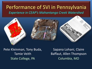
- 1. Performance of SVI in Pennsylvania Experience in CEAP’s Mahantango Creek Watershed Pete Kleinman, Tony Buda, Tamie Veith State College, PA Sapana Lohani, Claire Baffaut, Allen Thompson Columbia, MO
- 2. Allegheny Plateau Piedmont Coastal Plain Ridge & Valley WE-38 Klingerstown, PA ARS’s Mahantango Creek Watershed Long history of research on watershed runoff WE-38 Watershed (7.3 km2) FD-36 (40 ha) Mattern (11 ha)
- 3. fragipan no fragipan Fragipan soils and zones of saturation Well-drained Poorly drained Wet boot August 2003 Disconnected saturated areas Buda et al., 2009 (Hydrological Processes)
- 4. Fragipan soils enhance surface runoff generation 46 L 92 L 4620 L Albrights soil Fragipan, poorly drained Berks soil No fragipan, well drained
- 5. • SVI Runoff is slope dependent. • SVI is not affected by landscape processes. SVI and Slope
- 6. Representing field-scale runoff potential Other approaches exist Depth to Water Index least cost elevation difference to nearest stream 0 0.1 0.25 0.5 1 5 Depth to Water Index (m) Topographic Wetness Index natural logarithm of contributing area divided by slope Dry Wet Topographic Wetness Index 1.9 13.46.2 8.4
- 7. SVI leaching is primarily dependent on Hydrologic Soils Group SVI and SSURGO
- 8. Scale of soil survey data is often too coarse for today’s applications Mattern Watershed
- 9. SSURGO (Order 2) soils in Mattern 0.5 – 4.0 ha Berks B Berks C Berks D Berks C
- 10. Berks Berks Leck Kill Leck KillHartleton Albrights Order 1 soils in Mattern (< 0.5 ha) Berks Berks Leck Kill Leck Kill Hartleton Albrights fragipan
- 11. 0 - 0.68 0.68 - 1 Probability of R.L. Fe depl. No Fe depl. LiDAR derived model 72% correct prediction SSURGO SSURGO drainage Moderately well Moderately well- somewhat poor Poorly drained Somewhat poorly drained Well drained or somewhat excessively drained Fe No SS R. New soil mapping techniques
Hinweis der Redaktion
- 4
- 112 soil cores collected in WE-38 and morphology described to serve as a validation dataset. Model uses topographic position index