VIP Model Call Girls Chakan ( Pune ) Call ON 8005736733 Starting From 5K to 2...
2006-3015.pdf
1. Wildfire Impacts USGS Science Priorities
• The Federal Government annually
spends billions of dollars to suppress
wildfires.
• Wildfires increase the potential for
flooding, debris flows, and landslides.
• Smoke and other emissions contain
pollutants that can cause significant
health problems.
• Short-term effects: destruction of
timber, forage, wildlife habitats, scenic
vistas, and watersheds
• Long-term effects: reduced access to
recreational areas; destruction of com-
munity infrastructure and cultural and
economic resources
• Conduct research on previous wildfires,
including ignition sources, burn severity
patterns, season of burning, and fire size
• Study the effects of postfire runoff
and erosion on aquatic ecosystems and
species
• Expand the ability to monitor and
provide early warnings using new
technology, sensor webs, and satellite
technology
• Develop tools and methods to mini-
mize impacts on human life and prop-
erty, especially in the wildland-urban
interface
USGS Science Helps Build Safer Communities
Wildfire Hazards—A National Threat
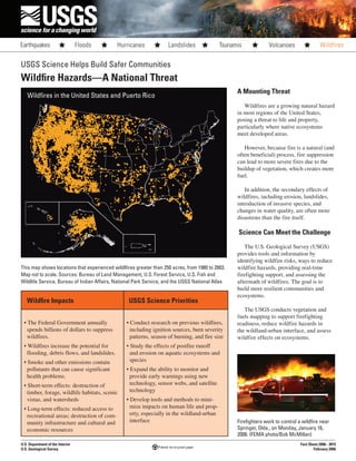
This map shows locations that experienced wildlfires greater than 250 acres, from 1980 to 2003.
Map not to scale. Sources: Bureau of Land Management, U.S. Forest Service, U.S. Fish and
Wildlife Service, Bureau of Indian Affairs, National Park Service, and the USGS National Atlas
U.S. Department of the Interior
U.S. Geological Survey
Fact Sheet 2006– 3015
February 2006
Wildfires in the United States and Puerto Rico
A Mounting Threat
Wildfires are a growing natural hazard
in most regions of the United States,
posing a threat to life and property,
particularly where native ecosystems
meet developed areas.
However, because fire is a natural (and
often beneficial) process, fire suppression
can lead to more severe fires due to the
buildup of vegetation, which creates more
fuel.
In addition, the secondary effects of
wildfires, including erosion, landslides,
introduction of invasive species, and
changes in water quality, are often more
disastrous than the fire itself.
Science Can Meet the Challenge
The U.S. Geological Survey (USGS)
provides tools and information by
identifying wildfire risks, ways to reduce
wildfire hazards, providing real-time
firefighting support, and assessing the
aftermath of wildfires. The goal is to
build more resilient communities and
ecosystems.
The USGS conducts vegetation and
fuels mapping to support firefighting
readiness, reduce wildfire hazards in
the wildland-urban interface, and assess
wildfire effects on ecosystems.
Firefighters work to control a wildfire near
Springer, Okla., on Monday, January 16,
2006. (FEMA photo/Bob McMillan)
2. Wildfire Facts
For More Information
http://www.usgs.gov/themes/Wildfire/
fire.html/
http://firescience.cr.usgs.gov/html/
sitemap.html
http://www.geomac.gov/
http://landfire.gov/
http://www.usgs.gov/
• More land has been affected by wildfires in recent years than at any time since
the 1960s. In 2004, wildfires burned more than 8 million acres in 40 States.
• The greater Yellowstone National Park fire of 1988 burned more than 1.2 million
acres.
• Wildfire severity has increased and fire frequency has decreased during the past
200 years.
• Many species depend on wildfires to improve habitat, recycle nutrients, and
maintain diverse communities.
• Land management agencies light “prescribed fires” under controlled conditions
for specific management objectives.
To determine how current
conditions differ from natural wildlfire
circumstances, the USGS studies
historical fire patterns—their size, how
they started, how hot they burned, and
what time of year they occurred.
The USGS is also developing methods
to monitor the effectiveness of treatments
to reduce fuel buildup, the effects of
wildfire on wildlife, and the ecological
effects of fuel-reduction measures and
postfire rehabilitation treatments.
Land managers use this information to
determine fire risk, plan fuel treatments,
and develop emergency response plans.
Tools and Teamwork
To aid land managers in developing
plans to minimize wildfire threats before
they occur or spread, the USGS and the
U.S. Forest Service developed the Fire
Potential Index (FPI), which depicts the
wildfire potential for forests, shrublands,
and grasslands.
FPI maps use satellite-derived
information to assess the impact of
vegetation on fire danger. The FPI is
updated daily to reflect changing weather
conditions and is used in daily wildfire
decisionmaking.
To monitor the risk of actively burning
wildfires, the USGS, in cooperation
with the National Interagency Fire
Center, developed GeoMAC. This is an
Internet-based mapping tool that provides
a national view of current wildfire
situations to fire managers and the public.
GeoMAC aids fire personnel by
displaying the most current wildfire
information available.
The USGS is also a member of
LANDFIRE, a multipartner wildfires,
ecosystem, and fuel-mapping
project. LANDFIRE data support
fuels treatments, incident response,
postfire recovery actions, and effective
monitoring.
After the Flames, the Risk
Remains
The less obvious but equally
devastating effects of wildfires occur
after the fire is extinguished. These
aftereffects include erosion, landslides,
debris flows, and altered water quality.
The risk of floods and debris flows
increases due to the exposure of bare
ground and the loss of vegetation.
Sediment, burned debris, and chemicals
affect water quality as well.
USGS Rapid-Deployment Data-
Collection Networks provide critical
information for postfire flood and debris-
flow warnings and on the response of
eroded, burned areas. This information
helps emergency management officials
with emergency response, postfire
mitigation, and rehabilitation planning.
USGS wildfire science is an integral
part of the Federal Government mission
to protect life, property, and natural
resources before, during, and after
wildfires.
A wildfire left very little of this home near
San Bernadino, Calif., in October 2003.
(FEMA photo/Kevin Galvin)
The evening sun barely penetrates smoke
and ash as evacuees flee Glenwood
Springs, Colo., because of spreading
wildfires on Saturday, June 8, 2002. (FEMA
photo/Bryan Dahlberg)
A wildfire in Yellowstone National Park,
Wyo., approaches a gift shop and lodge on
Wednesday, September 7, 1988. (National
Park Service photo)