Charting the Path to a Sustainable Mobility Future
Mitigating Vehicle-Miles Traveled (VMT) in Rural Development
1. Miller,
Ganson
1
Mitigating Vehicle-Miles Traveled (VMT) in Rural1
Development2
3
Ruth Miller (corresponding author)4
BlinkTag, Inc.5
1451 15th
Street6
San Francisco, CA 94103 USA7
Tel: 415-373-64428
Email: ruth@blinktag.com9
10
Christopher Ganson11
Governor’s Office of Planning and Research12
1400 10th
Street13
Sacramento, CA 95812 USA14
Tel: 916-324-923615
Email: chris.ganson@opr.ca.gov16
17
Word Count: 110 Abstract + 3,189 Text and References + 0 Tables + 2 Figures = 3,79918
19
Submitted for TRB 201520
2. Miller,
Ganson
2
ABSTRACT1
Vehicle-miles traveled (VMT) as an environmental review metric is more effective at2
combating climate change than level of service (LOS), and policymakers are beginning to3
advance its adoption for this purpose. Years of research and development prove that4
VMT mitigation strategies such as density, diversity, and design succeed in urban areas,5
but doubts remain about how VMT can be mitigated in rural development. This report6
reviews the current understanding of both urban VMT mitigation and rural development.7
Finally, additional literature and evidential case studies are explored to identify urban8
VMT mitigation strategies that can be modified for the rural scale as well as mitigation9
strategies unique to the rural context.10
3. Miller,
Ganson
3
1 INTRODUCTION1
California recently took the step towards combating climate change of retiring the level2
of service (LOS) environmental review metric, which is disposed to favor free flowing3
vehicular movement and greenhouse gas (GHG)-intensive development. Its replacement4
will be based on vehicle-miles traveled (VMT), which favors reduced vehicle use and5
therefore GHG-reductions (1). Moving forward, California’s environmental review will6
encourage California’s developers to mitigate the VMT generation of new development.7
Decades of research by Smart Growth proponents and New Urbanists will inform8
developers how to mitigate VMT in urban areas, but VMT mitigation in rural places is9
less understood. This issue will be very important to California as it works to meet its10
climate goals, as up to 95% of California’s land and 5% of its population is rural (2). This11
report inventories and assesses strategies that will enable development in these rural areas12
to strive for climate resiliency alongside their urban counterparts.13
2 LITERATURE REVIEW14
15
The subject of rural VMT mitigation sits between two broader questions: how is VMT16
mitigated, and in what way do rural places develop? Existing research provides clear,17
generalizable, and widely accepted strategies of urban VMT mitigation. Existing research18
also closely examines non-urban spaces, distinguishing the economic and physical19
characteristics that drive development of any kind.20
2.1 VMT Mitigation21
Cervero and Kockelman identified three “D’s,” principles for reducing VMT through22
planning and development (3). Other researchers later extended these three to six (4, 5).23
• Density24
• Diversity25
• Design26
• Destination accessibility27
• Distance to transit28
• Demand management of parking29
The combined effect of these choices is a reduction in VMT through four methods (5).30
• Shift mode choice31
• Increase vehicle occupancy32
• Reduce trip generation33
• Reduce trip lengths34
2.2 What is Rural?35
Current official definitions of “rural” are inadequate for comprehensive rural planning.36
Though no individual rural area has a large population, California’s aggregate rural lands37
occupy a large portion of the State and a significant population share. How large,38
precisely, is difficult to say. The three major taxonomical institutions in the United States39
(Census Bureau, Office of Management and Budget, Economic Research Service) and40
the State of California disagree on what constitutes rural (the California State Code41
applies 11 different definitions). These definitions all “round up” the urban/rural fringe42
4. Miller,
Ganson
4
(to use Census language) in varying degrees. This fringe area is considered in1
metropolitan planning, where the majority of population and activity are focused in2
metropolitan centers, but it is critical to rural planning, where these fringes are relatively3
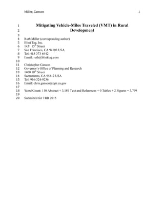
population dense and foretell the trajectory of new development (6). Based on the three4
Federal definitions, Figure 1 shows the share of California’s rural population, and Figure5
2 shows California’s share of rural land.6
7
FIGURE 1 Rural Percentage of California Population, 20108
9
10
FIGURE 2 Rural Percentage of California Land, 201011
Ruth Miller, at the University of California, Berkeley, proposed a framework of12
three placetypes for rural planning in California (6).13
• Productive: Low population density and growth, with economic reliance on extractive14
and agricultural (non-transferable) uses of the land itself.15
• Destinations: A large supply of seasonably occupied housing, high median household16
incomes, and essentially a population split between local staff of modest means and17
wealthier visitors.18
• Edge: Undeveloped land within urban boundaries, developed land beyond municipal19
services, or land within reach of urban centers but developed at too low a density to20
be extended urban services.21
5.5%
2.4%
0.1%
0.0%
1.0%
2.0%
3.0%
4.0%
5.0%
6.0%
Census: Rural OMB:
Nonmetro
ERS:
Completely
Rural
Rural Percentage of the California
Population, 2010
94.7%
36.4%
7.0%
0.0%
20.0%
40.0%
60.0%
80.0%
100.0%
Census: Rural OMB:
Nonmetro
ERS:
Completely
Rural
Rural Percentage of California Land
Area, 2010
5. Miller,
Ganson
5
3 METHODS1
VMT mitigation strategies emerged from reports and interviews from multiple sources.2
• Academic institutions3
• Professional organizations4
• Regional planning organizations5
• State and federal agencies6
• Transportation advocates and research groups7
• City and county governments8
• Urban, suburban, and rural developers9
The review process consisted of three steps.10
• Collecting accounts of rural projects for which VMT mitigation was an intended or11
unintended outcome12
• Classifying the project by rural placetype (Productive, Destination, Edge)13
• Identifying analogous urban VMT mitigation strategies, or new and uniquely rural14
strategies15
4 VMT REDUCTION STRATEGIES BY PLACETYPE16
The following sections review the VMT mitigation strategies appropriate for each rural17
placetype. Case studies are provided for each to illustrate combinations of these strategies18
in action. Most, but not all, of the case studies are from California.19
4.1 Productive Areas20
Reducing VMT in productive communities involves focusing development in more21
VMT-efficient centers and restricting it elsewhere. In addition to reducing VMT, this can22
reduce consumption of farmland and open space while maintaining small town character23
(6).24
4.1.1 Strategies outside Productive town centers25
• Develop new residential units at a density of 10 acres per unit or less (7).26
• Commit farmland, timber reserves, or other open spaces under a conservation27
easement or land trust. Many states offer reduced property taxes for land under28
easement, such as the Williamson Act in California (9).29
• Eschew new growth-inducing infrastructure, and limit new development to septic30
service and well water (10).31
• Reduce the need to travel for information by providing high quality, high-speed32
broadband Internet service (11).33
4.1.2 Strategies inside Productive town centers34
• Similar to the urban context, smaller lot sizes and higher density development make35
trip-chaining and active transportation more feasible.36
• Adapt the transportation network to accommodate active transportation, including37
sidewalks, buildings at a pedestrian-oriented scale, street-fronting buildings, bicycle38
lanes, and bicycle parking.39
• Enhance the small block grid system (8).40
6. Miller,
Ganson
6
• Develop affordable housing that balances the jobs-housing mix at each income level1
(9).2
• Construct a variety of building types and sizes, to support a mixture of uses, and3
reduce the need to travel long distances for basic goods and services (9).4
• Operate and subsidize vanpool programs to connect worker housing and related jobs.5
• Operate and subsidize on-demand shuttles for more infrequent trips, such as between6
seniors and medical care (9).7
4.1.3 Case studies of VMT mitigation in Productive areas8
The three square miles of Guinda, California (population 254) contain a small but9
walkable commercial center with basic services, at the heart of a much larger agricultural10
area. Residents will have to make a vehicle trip to obtain some goods and services, but11
can fulfill many needs locally, and even walk safely between many commercial12
destinations (12).13
The City of Woodland, California is also surrounded by agricultural farmland.14
Developers in Woodland observed a need to improve living conditions among15
farmworkers, and to reduce long driven trips (“super commutes”) from adequate housing16
many miles away. With a combination of city, state, and federal grants, private17
developers are constructing 60 units of affordable housing within the city limits. The18
units will be priced at 30-50% of area median income, and is on track to open March19
2015 (13).20
In another heavily agricultural region of California, the San Joaquin Valley,21
farmworkers pay a substantial portion of their income for unregulated vanpools to their22
worksites. After a tragic accident killed 13 farmworker passengers, the community23
sought and received $6 million in grants to establish the Agricultural Industries24
Transportation Services (AITS). The service began operating a network of vanpools in25
the San Joaquin Valley in 2002. The original program now operates 100 vans, is entirely26
supported by rider fees, and has been replicated in neighboring counties. Today, the AITS27
program eliminates 15 million VMT a year, provides safe transportation, and increases28
farmworker disposable income by 2 to 3 percent (11, 15).29
4.2 Destinations30
Destinations often have an especially high VMT per capita for two reasons. First, the31
local economy depends on visitors, many of whom may drive long distances to enjoy the32
local amenities. Second, high demand for second-homes and vacation rental property can33
put housing costs out of reach of local employees, forcing them to live elsewhere and34
commute long distances (6).
35
4.2.1. Strategies for Destinations36
• Focus new development intensity around the existing town center (7, 8).37
• Diversify new development types to mix land uses and reduce trip lengths for goods38
and services (such as child care).39
• Diversify residential housing types to accommodate a range of users, such as families40
(multiple bedrooms) and seniors (smaller units with small yards for easy41
maintenance) (15).42
• Develop quality affordable housing (16).43
7. Miller,
Ganson
7
• Follow principles of form-based codes to improve walkability and embrace the1
Destination’s existing marketable charm.2
• Implement pedestrian and bicycle way-finding signage to encourage visitors to3
explore without an automobile (8).4
• When local transit is available:5
o Orient new development to facilitate pedestrian and bicycle access to6
transit stops7
o Subsidize connecting service to new development8
o Provide free or subsidized transit passes to employees, residents, or guests9
(18).10
• When regional transit is available:11
o Focus new development around the regional transit connection12
o Provide bike-rentals or bike-sharing facilities at the transit station13
o Attract car-sharing services to the transit connection14
o Operate a shuttle between the transit connection and major destinations15
• Operate or contribute to a shuttle from nearby urban areas to the major destination16
(such as a ski shuttle, or to a casino/hotel).17
• Operate or contribute to a local shuttle between workers and job centers or between18
local attractions for visitors (19)19
• Purchase and dedicate land on the outskirts of the destination’s developed area to a20
land bank or trust, reducing the risk of future high-VMT development (9)21
• Commit to using local products and services in construction and operations (19)22
4.2.2 Case studies of VMT mitigation in Destination areas23
Mode shift to shuttles, busses, and trains can reduce VMT of travelers accessing24
Destination areas, while developing compactly, and mixing uses and providing for active25
transportation can reduce VMT within Destination areas themselves. .,.26
Kings Beach, California, on the north shore of Lake Tahoe, is an unincorporated27
community with a declining population of fewer than 3,800 residents. In spite of its lack28
of formal incorporation and small population, the community is incredibly dense, with29
over a thousand residents per acre. Most of these residents are service workers in the30
surrounding and costly Lake Tahoe area, and live in small and inadequate housing31
conditions. Other local service workers, unable to find any housing on Lake Tahoe,32
commute from the nearest major city, Reno, over 40 miles away (17). To address the lack33
of local, adequate, and affordable housing, a non-profit developer constructed 77 units of34
deed-restricted family housing priced at 30-60% of area median income. The three-story35
development is LEED-Silver, with a mixture of uses and services available on site.36
Residents also receive free passes for the local transit system, which has a stop on site37
(16).38
Fifteen miles northwest of Kings Beach, the town of Truckee is the commercial39
center of Lake Tahoe. Its small, walkable downtown includes an Amtrak train station,40
which offers regular from the nearby San Francisco Bay Area all the way to Chicago. Ski41
resorts offer shuttle service to the train station, and rental cars and bicycles are available42
as well. Though the surrounding forests, mountains and lake are the primary destinations,43
Truckee is a tourist attraction in its own right. Truckee is also home to the Sierra44
8. Miller,
Ganson
8
Business Council, which promotes the use of local materials in construction and1
development (supporting the local economy and reducing freight VMT) (19).2
The towns of Napa and Yountville are the largest towns in California’s Napa3
Valley. Both are popular among tourists that commonly arrive by vehicle from the San4
Francisco Bay Area, nearly 50 miles away. The towns experience intense periods of5
automobile congestion and higher than average rates of drunk driving incidents, as the6
major tourist destinations (vineyards) are inherently far apart and the primary feature is7
alcohol. In response to these concerns, Napa and Yountville area business created two8
private shuttle systems. The Napa Valley Wine Trolley is sponsored by vineyards and9
transports passengers on a daylong tour for a fee (20). The Yountville trolley is sponsored10
by the town, and transports anyone, resident or visitor, for free between any destinations11
within the town (21). These systems present two different models for visitor shuttles12
reducing VMT.13
4.3 Edge Communities14
Edge communities are located on the periphery of a city or metropolitan area. Though15
less populous than urban centers, Edge communities are generally well served by16
infrastructure. This infrastructure is often designed to support automobile-dependent and17
low-density development, and retrofitting these communities with VMT-efficient18
development can be challenging (6).19
4.3.1 Strategies for Edge Communities20
• Cluster new development compactly, including on infill sites when possible21
• Improve the mix of uses, adding destinations that allow shorter trips22
• Build a network of trails that offer active transportation options between the23
development and major destinations, such as other neighborhoods, schools, shopping,24
and recreation.25
• Provide sidewalk and street treatments that facilitate active mode transportation, such26
as illuminated crosswalks, bulb outs, pedestrian refuge islands, bike lanes, and27
protected cycle tracks (8).28
• Facilitate, promote, and subsidize the implementation and use of car sharing facilities29
or peer-to-peer car sharing among residents (22).30
• Commit undeveloped lands to a land trust, the Williamson Act or a Transferable31
Development Rights program (6).32
• Redevelop and intensify low-intensity development along major corridors. Sufficient33
intensification along such corridors can make transit feasible.34
• Unbundle parking from residential units, and offer car share vehicles on site (22).35
• Include or contribute to development that mitigates the community’s VMT, such as a36
centrally located neighborhood center or library (8).37
• Promote and/or provide schoolpooling options for parents, such as organized meeting38
places or ridesharing tools (23).39
4.3.2 Strategies for Developer/Employers in Edge Communities40
• Offer a parking cash-out option to employees.41
• Charge employees the daily market rate for parking, rather than subsidizing parking42
or charging a monthly fee (24).43
9. Miller,
Ganson
9
• Provide incentives to employees to carpool, bike, walk, or take transit (9)1
• Fund a Guaranteed Ride Home Program or Emergency Ride Home, which distributes2
vouchers for some number of free cab rides to commuters for emergencies when their3
carpool or transit options become untenable.4
• Provide bike lockers, changing areas, and showers on site5
• Encourage telecommuting (24).6
4.3.3 Case studies of VMT mitigation in Edge communities7
Because of their large scale, edge communities occasionally present the opportunity for8
adaptive reuse on a large footprint. One such project in Rohnert Park, in Sonoma County,9
is converting 175 acres (most of which is currently parking) into the Sonoma Mountain10
Village. This development includes 1,980 homes; 3,800 jobs; and 825,000 square feet of11
commercial, office, and retail space, and submitted an application for LEED-platinum.12
The site is served by a shuttle to the nearby Sonoma State University and was designed to13
anticipate a future commuter rail stop (25).14
The City of Covington is a small suburban community outside Atlanta in one of15
Georgia’s most foreclosed counties of the last decade. Though nearly all construction16
stalled in 2008, an affordable housing developer approached the city to build 6017
affordable, age-restricted apartments and townhomes near the walkable town square. The18
project, Harristown Park, opened in 2011, and currently has a waitlist of over 2,50019
applicants. Many of the initial applicants weren’t actually qualified to live in the20
development, indicating vast and unmet demand for compact housing even in suburban21
areas. Though the development is 15 miles from the nearest transit service, the city refers22
to the site as TOD, or transportation-oriented development (26).23
A 2009 study modeled the VMT outcomes of status quo and compact24
development in the Towns of Lisbon and Sanford, Maine. These two small, rural towns25
have transit, but service is very limited and 93% of commuters drive. The study found26
that even without urban-style transit, the densification and mixing of residential and27
employment growth as infill still produced an “observable impact” on VMT and average28
trip lengths (27).29
5 CONCLUSIONS30
To meet California’s climate goals, both urban and rural development will require a clear31
articulation of local challenges and opportunities and thoughtful development. Increased32
understanding of rural contexts will support more effective climate change policies33
statewide.34
6 FURTHER RESEARCH35
This paper explores strategies for private developers, but the public sector also has a role36
in rural VMT mitigation. Land banks and Transferable Development Right (TDR)37
programs are just two examples of VMT mitigation methods that require public38
implementation and can be successful in rural areas.39
Regrettably, rural communities under intense development pressure suffer an40
unfortunate Catch-22: local governments only have the tax base to support their current41
population, and often don’t have the resources to adequately plan for growth until after42
development has occurred. Future research should also focus on how to support long-43
10. Miller,
Ganson
10
range planning for growth in understaffed and unprepared small towns to handle intense1
development pressure.2
7 WORKS CITED3
1. Ewing, R. and R. Verver. Travel and the Built Environment. Transportation Research4
Record, Vol. 1780, 2001, pp 87-114.5
2. U.S. Census Bureau, Geography Division. Percent urban and rural in 2010 by state.6
2010. http://www2.census.gov/geo/ua/PctUrbanRural_State.xls. Accessed July 25,7
2014.8
3. Cervero, R. and K. Kockelman. Travel demand and the 3Ds: density, diversity and9
design. Transportation Research Part D, Vol. 2, 1997, pp. 199-219.10
4. Lawrence Berkeley National Laboratory. Energy Aware Planning Guide. 2009.11
http://puff.lbl.gov/transportation/transportation/energy-aware/energyaware-l-1-12
1.html#smart Accessed July 25, 2014.13
5. Ewing, R., D. Chen, K. Bartholomew, J. Walters and S. Winkelman. Growing14
Cooler: The Evidence on Urban Development and Climate Change. 2008.15
Washington: Urban Land Institute.16
6. Miller, R. Beyond "Urban Planning": An Overview of Challenges Unique to Planning17
Rural California, 2013. University of California, Berkeley Masters Thesis.18
http://www.scribd.com/doc/129955232/Beyond-Urban-Planning-An-Overview-of-19
Challenges-Unique-to-Planning-Rural-California. Accessed July 25, 2014.20
7. Duany, A., Plater-Zyberk, E., Speck, J. (2000). Suburban Nation: The Rise of Sprawl21
and the Decline of the American Dream. North Point Press.22
8. Shoup, Lilly, and Becca Homa. "Principles for Improving Transportation Options in23
Rural and Small Town Communities." Transportation for America, 2010.24
http://t4america.org/wp-content/uploads/2010/03/T4-Whitepaper-Rural-and-Small-25
Town-Communities.pdf. Accessed July 25, 2014.26
9. Sacramento Area Council of Governments. Rural Urban Connection Strategy, 2011.27
http://www.sacog.org/2035/files/MTP-SCS/appendices/E-28
2%20Rural%20Urban%20Connections%20Strategy.pdf Accessed July 25, 2014.29
10. Marion County, Oregon. Unincorporated Rural Community Plans, 2007.30
http://www.co.marion.or.us/PW/Planning/zoning/ruralcommunityplans/Rural+Comm31
unity+Plans.htm. Accessed July 25, 2014.32
11. Washington State Department of Transportation. Impacts of VMT Reduction33
Strategies on Selected Areas and Groups, 2011.34
http://www.wsdot.wa.gov/research/reports/fullreports/751.1.pdf. Accessed July 25,35
2014.36
12. U.S. Census. 2010 Demographic Profile Data, Guinda CDP.37
http://factfinder2.census.gov Accessed July 25, 2014.38
13. Moffitt, B. Farmworker Housing Project Comes to Woodland. Capitol Public Radio,39
2013. http://www.capradio.org/articles/2013/12/05/farmworker-housing-project-40
comes-to-woodland. Accessed July 25, 2014.41
14. Caltrans. The Agricultural Industries Transportation Services: Meeting The Transit42
Needs Of Rural Californians. 2006. http://www.dot.ca.gov/hq/MassTrans/Docs-43
Pdfs/AITS_PROJECT.pdf. Accessed July 25, 2014.44
11. Miller,
Ganson
11
15. Ball, S. M. Aging in Place: A Toolkit for Local Governments. American Association1
of Retired Persons, 2014. http://www.aarp.org/content/dam/aarp/livable-2
communities/plan/planning/aging-in-place-a-toolkit-for-local-governments-aarp.pdf.3
Accessed July 25, 2014.4
16. Kang, M. President of Domus Development LLC and the California Infill Builders5
Association. Interview by R. Miller. August 14, 2012.6
17. KRNV-DT Reno. Kings Beach gets help with housing shortage. 2012.7
http://www.mynews4.com/news/story/Kings-beach-8
tahoe/BhSYWeyN4Em7Pn2nzlRzAA.cspx. Accessed July 25, 2014.9
18. GreenTRIP. Transform. http://www.transformca.org/landing-page/greentrip.10
Accessed July 25, 2014.11
19. Jones, G. Vice President and Chief Operating Officer, Sierra Business Council.12
Interview by R. Miller and L. Bedsworth. August 8, 2012.13
20. Napa Winery Shuttle. http://www.wineshuttle.com. Accessed July 25, 2014.14
21. Yountville Trolley. Vine Transit. http://www.ridethevine.com/yountville-trolley.15
Accessed July 25, 2014.16
22. Cervero, R. San Francisco City CarShare: Second Year Travel Demand and Car17
Ownership Impacts. Transportation Research Record: Journal of the Transportation18
Research Board, Vol. 1887, 2004. pp 117-127.19
23. Metropolitan Transportation Commission. Third Party Mobile Apps and Websites.20
2014. http://511.org/apps-websites.asp. Accessed July 25, 2014.21
24. Shoup, D., Tumlin J. Notes on Ending Free Workplace Parking for CARB, SCAG,22
MTC. 2013. http://www.cities21.org/dpwg/parkingPolicy.htm. Accessed July 25,23
2014.24
25. Vinson, R. Director of Planning, City of Covington. Interview with R Miller. May 9,25
2014.26
26. University of Vermont Transportation Center. Transportation Impacts of Smart27
Growth Development in Maine. 2009.28
http://www.uvm.edu/~transctr/research/trc_reports/UVM-TRC-09-005.pdf. Accessed29
July 25, 2014.30