Data capture with Leaflet and OpenStreetMap
•
1 gefällt mir•701 views

Louise Sing's lightning talk on how she used LeafletJs and OpenStreetMap to build a mobile application to capture data about forest usage. Presented at 6th Scottish QGIS UK user group meeting.

Empfohlen
Empfohlen
Weitere ähnliche Inhalte
Was ist angesagt?
Was ist angesagt? (20)
Mehr von Ross McDonald
Mehr von Ross McDonald (20)
Kürzlich hochgeladen
Kürzlich hochgeladen (20)
Data capture with Leaflet and OpenStreetMap
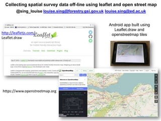
- 1. Collecting spatial survey data off-line using leaflet and open street map @sing_louise louise.sing@forestry.gsi.gov.uk louise.sing@ed.ac.uk http://leafletjs.com/ Leaflet.draw https://www.openstreetmap.org Android app built using Leaflet.draw and openstreetmap tiles
- 2. Data stored in GeoJSON format Digitise points, lines and polygons