Rolta Geomatica Suite
•
1 gefällt mir•318 views

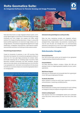
Rolta Geomatica Suite is a single integrated software system, which brings highest degree of automation for Remote Sensing and Image Processing and turns imagery into answers and offers robust solutions for all types of desktop Geomatics. It helps in various GIS based workflow applications and advanced image analysis such as change detection. The software brings patented algorithms for image classification, cartographic map production, hyper-spectral analysis, advanced Data visualization and editing and raster spatial analysis.

Empfohlen
Empfohlen
Weitere ähnliche Inhalte
Ähnlich wie Rolta Geomatica Suite
Ähnlich wie Rolta Geomatica Suite (20)
Mehr von Rolta
Mehr von Rolta (20)
Kürzlich hochgeladen
Kürzlich hochgeladen (20)
Rolta Geomatica Suite
- 1. Rolta Geomatica Suite: An Integrated Software for Remote Sensing and Image Processing Rolta Geomatica Suite is a single integrated software system, which brings highest degree of automation for Remote Sensing and Image Processing and turns imagery into answers and offers robust solutions for all types of desktop Geomatics. It helps in various GIS based workflow applications and advanced image analysis such as change detection. The software brings patented algorithms for image classification, cartographic map production, hyper-spectral analysis, advancedDatavisualizationandeditingandrasterspatialanalysis. PowerfulImageAnalysis Software Trusted by thousands of customers in over 135 countries, Rolta Geomatica has long been the comprehensive geospatial software of choice for all of your geo-image processing and analysis needs. Continually improving with an increasing range of functions, Rolta Geomatica simplifies orthomosaic and other workflows, provides rapid and accurate results, and ultimately saves your time and effort in your geospatial work. Automation and versatility are the key values that allow you to process analyze and comprehend geospatial data in ourchangingworld. DedicatedtoGeospatialBeginners andExpertsAlike Rolta has been developing complete and integrated software featuring the tools professionals need for remote sensing, digital photogrammetry, image analysis, map production, mosaicking and more for over 30 years. Our strength lies in our uncompromising dedication to being second to none in the imagery processing pillars thatareatthefoundationofthegeospatialworld. End-to-EndExpertise Over 550 functions give control over all aspects of your geospatial imageprocessing,analysis&qualityassurance PowerfulPlatform The Rolta Geomatica Platform includes a Python API, SDK and developer version to integrate geospatial capability into your custom applications Multi-SensorSupport Rolta users can directly open and manipulate data from a growing list ofover180supportedgeospatialfiletypes. The World’s BestOrtho Rolta's software is simply the world’s best in geometric correction, orthorectification,mosaicking,andDEMextraction. EfficientAutomation Wizard-based tools, scripting, batch processing and visual modeling aredesignedtokeepyourprojectsmovingforwardonschedule. Industry LeadingSupport Fast response times from knowledgeable experts and a dedicated online help center means answers are never more than a few clicks away. RoltaGeomatica Strengths Rolta Geomatica software is your best choice for orthorectification, mosaicking, DEM extraction and geospatial image analysis, with support for a growing list of over 180 sensors andfile-types. 1
- 2. geo-referencing, channel combinations and bit-depth. By using simple polygon selection in your imagery, you can select, copy and paste the best parts of the best images for your final mosaic. This feature extends Rolta Geomatica’s DEM and ortho-mosaic production, or can be used to enhance any type of overlapping images. Along with automatic color balancing and cutline placement for mosaics, achieve consistently pleasing results thanks to global and local exposure correction, contrast adjustment (sigma), as well as dodging points along cut lines or within images. Our overall workflow and interfaces eliminate the need for post-mosaic editing in other software. With features like automated GCP and tie-point collection, multi-way point selection and the ability to calculate absolute, relative or combined models, Rolta Geomatica provides everything you need for fast, accurate results. EXIF tags and flight line angles make project set-up simple, and our efficient editing tools, image deactivation feature and detailed reporting let you spend less time checking your orthophotos,soyoucanstartyournextprojectsooner. Extracting high quality, high resolution Digital Elevation Models from the latest sensors is easier and faster than ever. Work with 100’s or 1,000s of stereo pairs, ingest billions of LIDAR points, contour lines and other elevation data to create seamless elevation models at full resolution. Effective smoothing and interpolation removes holes, giving you the complete coverage you need for your orthos and mosaics. Rolta has a long history of developing specialized tools for SAR, including compact SAR, polarimetry and specific sensor models. SAR is effective for many applications due to its ability to collect fine resolution imagery in all illumination and weather conditions. The Rolta Geomatica Radar Ortho Suite is purpose-built for orthorectification and DEM extraction of radar data and the output you produce can be combined with other microwave and optical sensors as well as vector data to maximize information delivery. The SAR Polarimetry Workstation is a comprehensive toolkit to develop techniques for applying SAR polarimetry to Earth-monitoring and resource management challenges. This state-of-the-art software reads the radiometric and geometric metadata to provide target selection, target analysis, and dataset processing utilities designed specifically for Polarimetric SAR data. The Rolta InSAR package permits the extraction of DEMs and measurement of ground deformation, and is designed to make processing and operations easierforbothexpertsandnon-SARexpertsalike. Fast,AccurateModelCalculation HighResolutionDEMExtraction AdvancedRadarProcessingandAnalysis 2 ApplicationsandIndustries MoreApplicationsandIndustries CropMonitoringandAgriculture Crossqueuingmulti-sensorsatellitedataforefficientcropmonitoring SeaIceMonitoring Unique polarimetric SAR capabilities discriminate between different icetypesforcommercialandscientificmarineactivities CountrywideMapping Countrywide mapping through the high performance RGXL system, withqualityassuranceandeditinginRoltaGeomatica PetroleumExploration Structural mapping and lineament analysis for petroleum exploration usingremotesensing UniqueandEffectiveEditingTools Live DEM offers you a simple, less expensive, more efficient way to produce terrain models for your orthomosaics. See and edit DTM blunders in an ortho preview that updates with your changes - You immediately see your fix applied without having to reprocess the entire scene. This makes editing faster, easier, and doesn’t require 3D-stereohardwareortheneedtoregenerateandrecheckscenes. Smart GeoFill provides you with georeferenced copy and paste for imagery. Enhance and retouch orthomosaics while maintaining full ?DefenseandIntelligence ?WildlifeManagement ?UtilityManagement ?UrbanPlanning ?Surveying ?AssetMapping ?Insurance ?Many more… ?Agriculture ?ResourceMapping ?RealEstate ?MiningandEarth ?DisasterManagement ?Forestry ?CoastalMonitoring ?OilandGasExploration
- 3. SensiblePackaging FlexibleLicensingandOperations Whether your project is large or small, satellite or aerial, optical or radar, Rolta Geomatica has the tools required to make your job easier. Rolta Geomatica is packaged simply and easily so you only purchase thenecessitiesforyourprojects. ¨Floatinglicenses ¨Desktopandserveroperations RoltaGeomaticafor Education RoltaGeomaticaPlatform Key benefits The increasingly important role of geographic information in almost every academic discipline, coupled with its fast-growing field of high- tech career options, will add a new dimension to a wide variety of academic studies at your institution. Professional software that helps students visualize, research and analyze geographic information demonstrates how important spatial analysis is to sound decision making. The Rolta Geomatica Education Suite bundles base modules into one package, with optional, advanced add-ons for atmospheric correction and for SAR analysis (including InSAR and polarimetry). Licensing options are available for students, labs and departments, andfullacademicsites. Rolta Geomaticais a powerful and modular platform designedto exist at the core of your geospatial business. Over 550 geospatial functions optimized for performance and accuracy are assembled and integrated to support image analysis, ortho-mosaic production, and workflow automation. Use these to develop new geospatial applications, generate intelligent business products, or customize youroutputforanynumberofmarketdemands. ?Single integrated entry point for all the Geomatics operations in theorganization ?More than 150+ sensor supports for all the industry standard sensors ?Advanced image processing algorithms ensuring the best analysisofimagedata ?Visual modeling & batch processing for faster turnaround of images&vastalgorithmsupport 3 Rolta Geomatica Core Rolta Geomatica Prime Rolta exclusive GDB technology Rolta Focus viewing environment Cartographic map production 3D perspective scene generation & fly-through Interactive spatial analysis tools Scripting via Python, EASI, or Modeler Radar analysis tools Satellite Ortho Suite Air Photo Ortho Suite ADS Ortho Suite Radar Ortho Suite Pan Sharpening Object Analyst Ortho Production Toolkit InSAR Automatic DEM Extraction Historical Airphoto Processing (HAP) Atmospheric Correction (including ATCOR) SAR Polarimetry Workstation (SPW) Rolta OrthoEngine Optical image analysis Available Available Available Available Available Available Available Available Requires one of the Ortho Suites listed above Available Requires Radar Ortho Suite Requires one of Satellite, Air Photo, or Radar Ortho Suite Requires one of the Ortho Suites listed above Recommended Requires Radar Ortho Suite Requires one of Satellite, Air Photo, or Radar Ortho Suite Requires Air Photo Ortho Suite and Ortho Production Toolkit Available Available Available Available Available Available Available Available ROLTA GEOMATICA DEVELOPER 550+Algorithms PYTHON API Development Environment THIRD PARTY INTEGRATION External Tools and Data EXPERT KNOWLEDGE Subject Matter Express PURPOSE BUILT SOLUTIONS Develop Your Solution
- 4. TechnicalSupport OSSupport Customer support is a vital part of the Rolta experience. We promote a customer- first environment to deliver rapid, accurate, personalized responses,proactivecommunicationandclear, concisesolutionsforalltypesofsupportrequests. RoltaGeomaticaisavailableonthefollowingoperatingsystems: 4 Rolta India Ltd Rolta Tower "A", Rolta Technology Park, MIDC - Marol, Andheri (East), Mumbai - 400 093, INDIA. Phone: +91(22) 2926 6666 / +91(22) 3087 6543 I Fax: +91(22) 2836 5992 I Email: indsales@rolta.com I Web: www.rolta.com Windows Vendor: Microsoft Supported Versions: 64 bit Windows 7 and later Linux Vendor : CentOS/RHEL Supported Versions : 7.x