
Empfohlen
Empfohlen
Weitere ähnliche Inhalte
Andere mochten auch
Andere mochten auch (13)
Ähnlich wie os2stl
Ähnlich wie os2stl (20)
Kürzlich hochgeladen
Kürzlich hochgeladen (20)
os2stl
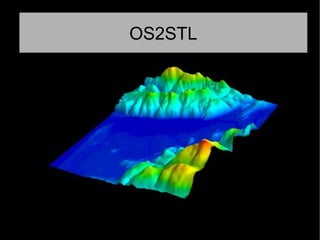
- 1. OS2STL
- 2. Project Description Our program takes a given post code or OS map reference to create a .STL file of the area which can then be sent to a 3d printer. In this way you can easily visualise large areas of terrain and make decisions regarding development from this. All of our code is available on github at: github.com/RobertABT/heightmapwebapp Live demo os2stl.co.uk
- 3. The Team Robert Buchan-Terrey Ferdia McKeogh Linus Kirkwood
- 4. Why? A year ago I was looking around at 3d printing areas of land to help plan a radio broadband link which required line of sight. Scale models of this sort could be used by anyone from model hobbyists, to tabletop gamers to property developers.
- 5. Existing solutions There are some existing tools and methods to create .stl files from given areas but they are either expensive and closed source, fiddly or very difficult to implement. (For loading terrain data into Openfoam there is an 18 page pdf document!)
- 6. The data Our project uses Ordnance Survey Terrain50 data files (which are downloadable from their website) to generate the .stl files http://www.ordnancesurvey.co.uk/business- and-government/products/terrain-50.html It also uses an open source API to convert post codes to OS grid references. http://www.nearby.org.uk/api/
- 7. The code The web app uses a mix of Python (which does the core processing) along with Javascript and HTML (to display the webpage and the .STL file preview)