SlideShare ist ein Scribd-Unternehmen logo
1 von 1
Downloaden Sie, um offline zu lesen
Sentiero 1 - Route 1
Guggiate - Brogno - Rovenza - Parco S. Primo - Bocchetta Terrabiotta
Dislivello in salita: 1155 mt - Tempo totale impiegato: 4h 00 min - Difficoltà: E = escursionistico
facile. Elevation gain: 1155 m - Total time: 4h - Difficulty: E = easy hike
Dal borgo di Bellagio si percorre per un chilometro e mezzo la strada Provinciale costiera per Como (anche
servizio bus) e si raggiunge la frazione di Guggiate ove inizia il sentiero 1. Dalla piazzetta della chiesetta di S
Andrea in Guggiate si imbocca la via Ciceri, a destra dello scenografico portale di Villa Ciceri, che attraversa
la borgata fino ad superare il torrente Perlo (a sinistra resti di allevamenti di trote e di antica filanda). Dopo il
ponte si imbocca una scalinata che sale fino ad incrociare una strada asfaltata, girare a sinistra e proseguire in
salita fino a superare la piazzola dell’elisoccorso e un cascinale che domina i pascoli e i frutteti di Cagnanica.
La strada finisce ed inizia una mulattiera che sale fra muretti rivestiti di edera; al termine della salita girare
a sinistra in direzione Perlo (la deviazione a destra porta in 15 minuti alla frazione Vergonese ). Dopo circa
200 metri girare a destra per la mulattiera che sale superando le ultime villette, una cascina e, dopo alcuni
tornanti in un fitto castagneto, raggiunge la località Begola con due cascine su un ripiano erboso. La traccia
del sentiero si allarga ora in una sterrata che sale in lieve pendio fra boschi e prati fino a costeggiare il parco
di Villa Mariani per arrivare alla località Brogno (597m.s.l.m - 1 ora). Il nostro itinerario prosegue, segnavia 1,
deviando a destra fra le case in direzione Rovenza e si sale lungo una carrareccia. Al termine della salita si
sbuca in una radura con una isolata cappelletta, (a destra inizia il sentiero alternativo 1A che porta a Paum
attraverso i boschi lungo il tracciato della antica mulattiera) proseguire diritto lungo la sterrata fra radure e
prati terrazzati fino all’abitato di Rovenza. Inizia ora la strada asfaltata che sale a destra che termina dopo
circa 2,5 chilometri alla località Paum; oltrepassare il cancello e proseguire lungo il sentiero che sale in
un bosco di faggi fino a sbucare nei pascoli dell’Alpe delle Ville. Il sentiero, dopo aver attraversato i prati,
arriva ad un cancello e ad un strada sterrata. Girare a sinistra, oltrepassare la costruzione della vecchia
Colonia Bonomelli e proseguire in piano fino alla strada asfaltata e ai parcheggi del parco Monte S. Primo
(1100m.s.l.m - 3 ore 20 minuti). Qui si segue sulla destra (segnavia 1) la strada asfaltata che conduce all’Alpe
del Borgo attraverso i prati che costituiscono le piste da sci del Forcella. Giunti all’Alpe si salgono, tenendo
la destra, nel pascolo le tracce di sentiero retrostanti l’edificio fino ad imboccare una stradina sterrata verso
destra che entra in un bosco di faggi. In pochi minuti si giunge ad una bocchetta (dalla quale è possibile
anche fare una deviazione a sinistra e salire in 10 minuti al Monte Forcella, stazione di arrivo di impianti da
sci. Dalla bocchetta si sale a destra lungo un sentiero che sale i prati lungo la cresta. Terminato il prato si
può scegliere se seguire la traccia in diagonale a mezza costa attraverso un bosco di ontani cresciuto su una
vecchia pista da sci e che arriva alla bocchetta di Terrabiotta (1375 m.s.l.m. – 4 ore) oppure proseguire verso
la cima del Monte Ponciv (1453 m.s.l.m.), dove è presente una costruzione con antenne.
Follow the provincial lakeside road for Como from the village of Bellagio for one and a half kilometres (you
can also take the bus) until you come to the hamlet of Guggiate where Route 1 begins. From the little
square in front of the Church of Sant’ Andrea in Guggiate take via Ciceri, to the right of the striking portal
of Villa Ciceri. This crosses the hamlet until it passes the Perlo stream (to the left are the remains of trout
breeding farms and an old spinning mill). After the bridge, take the steps up to cross over an asphalt road,
turn left and continue walking uphill to pass the helicopter rescue pad and the farmstead that overlooks
the pastures and orchards of Cagnanica. The road ends and a mule track starts to ascend, bordered by
low, ivy-covered walls. At the end of the uphill stretch, turn left towards Perlo (the detour to the right leads
to the hamlet of Vergonese after a 15 minute walk – trail sign 15). After about 200 metres turn right onto
the uphill mule track which passes the last small villas and a farmstead and, after a few sharp turns in a
dense chestnut wood, arrives in the area of Begola, with two farmsteads on grassy level ground. The trail
now widens into an unpaved route, which ascends gently between woods and pastures until it borders
the grounds of Villa Mariani and comes to the area of Brogno .The route continues, following trail sign 1,
deviating to the right between the houses towards Rovenza where you ascend along a cart track. At the
end of the uphill, you emerge in a clearing with an isolated little chapel (on the right starts trail 1A, which will
take you to Paum through the wood, along the old mule track), then continue straight along the unpaved
road between clearings and terraced meadows until you come to the village of Rovenza. Now begins an
asphalt road to the right, which leads uphill for around 2.5 kilometres to the area of Paum. Go through the
gate and continue along the trail that goes uphill through a beech wood, until you emerge in the pastures
of Alpe delle Ville. After having crossed the meadows the trail comes to a gate and an unpaved road. Turn
left, passing the old Bonomelli building and continue on the flat until you reach the asphalt road and the car
parks of the Mount S. Primo park .Here veer right (trail sign 1) to follow the asphalt road that leads to the
Alpe del Borgo.When you reach the alp, continue to follow the trail uphill to the right through the pasture,
behind the building, until you come to a small unpaved road towards the right that enters a beech wood.
In a few minutes you will reach a saddleback, where you can also make a detour to the left and walk 10
minutes uphill to Monte Forcella. From this saddleback, go right uphill along a trail through the meadows
along the crest. When the meadow ends you can choose whether to follow the trail diagonally between the
lake shore and the hilltop through an alder wood that has grown on an old ski slope and that leads to the
bocchetta di Terrabiotta, or continue towards the peak of Monte Ponciv (1453 m above sea level), where
there is a building with an antenna.
Sentiero 16 - Route 16
Vassena - Civenna - piano Rancio - Alpe Spezzola
Dislivello in salita: 1150 mt - Tempo totale impiegato: 3h 40 min - Difficoltà: E = escursionistico
medio. Il sentiero può essere scivoloso, necessitano calzature adatte.
Elevation gain: 1150 m - Total time: 3h 40 min - Difficulty: E = medium difficulty hike. The
route may be slippery. Use suitable footwear.
Vassena è una frazione del Comune di Oliveto Lario, raggiungibile con autobus linea Lecco - Bellagio o
con battello che collega Lecco con Bellagio. Dalla piazza della chiesa (interessante il porticciolo), tenendo
la destra si sale in via Roma, si attraversa la provinciale, si imbocca di fronte via Carcano e si prende
a destra. Dopo un piccolo parco giochi inizia la salita (attenzione seguire le frecce per “Civenna” e non
quelle per “Civenna 2”). La strada svolta a sinistra e poi a destra e terminato l’asfalto e un breve tratto in
cemento, riprende il corso come mulattiera. Si può notare dalla pavimentazione come una volta fosse una
via importante. Attraversata una zona boscosa si arriva ad una carozzabile il località Palembri di Civenna. Si
sale a destra e ad un bivio si tiene la sinistra. Attraversata la strada provinciale Bellagio - Magreglio (Ghisallo)
si passa nel paese (600 m.s.l.m. - 1 ora 30 minuti) salendo per una strada che si trasforma in mulattiera.
Usciti dall’abitato e raggiunte le costruzioni dell’acquedotto tenere la destra e proseguire la salita fino a
raggiungere Cascina Giacinta. Proseguire sulla destra in piano e girare a sinistra al primo sentiero che sale.
Giunti alla piana di Piano Rancio (990 m.s.l.m. - 2 ore 40 minuti), imboccare la strada in piano a sinistra del
ristorante Stella Alpina; proseguire fino in fondo ove inizia la salita al Rifugio Anna Maria. Tenere la destra
e prima del rifugio salire nel prato verso sinistra a costeggiare una recinzione. Girare a sinistra in piano nel
bosco fino a raggiungere un vecchio impianto Skilift, salire, inoltrarsi nel bosco, superare la valletta e salire
sul versante destro orografico del torrentello. Il sentiero prosegue con media salita nel bosco fino a sbuccare
nei prati del versante sud-est del Monte Poncivo. Si incontra il sentiero che N. 2 che proviene sulla sinistra
da S. Primo. Proseguire a mezza costa aggirando in piano il pendio fino a raggiungere la strada sterrata
(sentiero1 = dorsale Brunate-Bellagio). Girando a sinistra si scende all’Alpe Spezzola e poi alla colma di
Sormano, girando a destra si raggiunge la bocchetta di TerraBiotta, la vetta del S. Primo o si scende a S.
Primo Parco.
Vassena is a hamlet in the municipality of Oliveto Lario, which you can reach by bus on the Lecco-Bellagio
route or by boat from Bellagio to Lecco. From the church square walk along the lakeshore and take Via
Macchiavelli, cross the provincial road, take via Carcano opposite and then go right. The uphill begins on
the left(follow the arrows for “Civenna” and not “Civenna 2”). The road at the end of the asphalt and a
short stretch in cement continues as a mule track. You can see from how it is made that is was once an
important road. Cross a wooded area to reach a carriage road in the Palembri area of Civenna. Go uphill
to the right, take via San Vincenzo and then left in via Grèe. Once you reach the village, cross the Bellagio
- Magreglio (Ghisallo) provincial road, take via Frassi and go uphill though via Formicosa; when you reach
the wash house turn left into via Dante Alighieri. Once you leave the hamlet and reach the aqueduct, turn
right and continue uphill to the Giacinta farmstead. Continue to the right on the flat and turn left at the
first trail leading uphill. When you reach the Piano Rancio plain, take the level road to the left of the Stella
Alpina restaurant and continue to the end until you reach the trail uphill to the Anna Maria Refuge. Keep
right and go up the meadow towards the left before the refuge, next to a fence. Turn left on the flat into the
wood until you come to an old ski lift, ascend, enter the woods, pass the little valley and ascend the right
hand side of the small stream. The trail continues with a semi-steep uphill into the wood until it emerges
in the meadows on the south-east side of Mount Ponciv. Here it meets Route 2 from S. Primo on the right
Continue on the right until you come to the unpaved road that goes from Colma di Sormano to the peak
of s. Primo; you are now on Route 1.You can now decide whether to turn left to descend to Alpe Spezzola
and then reach the Colma di Sormano, or turn right to reach the Bocchetta di Terrabiotta , the peak of S.
Primo or to descend to the S. Primo Park.
Sentiero 2 - Route 2
Visgnola -Belvedere Makallè - Chevrio - Regina Pacis - Cascina Giacinta - Pietra
Lentina - Parco monte S. Primo – Alpe Spezzola
Dislivello in salita: 1040 mt - Tempo totale impiegato: 4h 45 min - Difficoltà: E = escursionistico
facile. Elevation gain: 1040 m - Total time: 4h 45 min - Difficulty: E = easy hike
Si lascia l’auto nella piazza della chiesa di Visgnola, a due chilometri dal borgo di Bellagio. (Visgnola è anche
raggiungibile con servizio autobus - linea per Lecco). Uscendo dalla piazza con direzione ovest, si risale
la provinciale via Valsassina direzione Ghisallo -Erba e dopo 80 m. si imbocca una scalinata sulla sinistra
(segnavia 2). Il sentiero prosegue in ripida salita nel prato e nel bosco, seguire i segnavia bianco-rosso. Si
sbuca dal bosco e giunti a Cascina Elisa fare attenzione al sentiero che devia, in piano, verso sinistra; dopo
circa 100 m girare a destra e risalire il prato seguendo l’indicazione Chevrio. Superate alcune facilissime
roccette si giunge ad una sterrata da imboccare in salita. Costeggiare la recinzione verde a sinistra e poi
il muro di cinta, dopo 400 m sulla destra affacciatevi al belvedere del Makallè (581 m.s.l.m. - 55 min.) e
godetevi una meravigliosa vista sul centro Lago di Como. Proseguendo sulla strada sterrata, superate la
Trattoria Baita - Belvedere (bel panorama) e scendete fino al borgo di Chevrio. Superate la cappelletta e
la fontana salendo dritto lungo la strada asfaltata arrivate alla provinciale, girare a destra e scendere per
circa 200 metri. Al N. civico 206 girare a sinistra e imboccare una sterrata che è costeggiata da recinzioni.
(segnavia 3) Si prosegue in salita, superando delle ville e l’agglomerato di Cascine Gallasco, fino a sbucare
sulla provinciale all’altezza della chiesina Regina Pacis (696 m.s.l.m. - 1 ora 45 minuti). Girando a sinistra
lungo la provinciale (direzione villa Mora) si arriva all’imbocco (a destra) di via Mora, una strada asfaltata in
salita.
Si prosegue fino in fondo dove la strada finisce in corrispondenza di una cascina (con affresco di una
Madonna). Il sentiero prosegue sulla sinistra in falso piano costeggiato da cespugli. Si sbuca poi al Munt
del Mot - cascina Dalcò, dove al bivio si gira a sinistra, fino alla mulattiera che proviene da Civenna ove si
gira a destra. Proseguendo lungo la mulattiera, e si giunge alla cascina Giacinta ove una fontana potabile
vi permetterà di dissetarvi. Si prosegue lungo il sentiero che si inoltra nel bosco e con leggera salita, si
superano dei cancelli fino a pervenire, con un ultimo strappo del sentiero, alla Pietra Lentina, il masso
erratico più grande del triangolo Lariano. (Volendo è possibile, a metà percorso, deviare a sinistra verso
PietraLuna / Pian Rancio). Di fronte alla Pietra Lentina, a sinistra, dalla strada Provinciale sale un sentiero
nella pineta che prosegue a mezza costa fino a sbucare, in prossimità di un palo dell’ Enel, nel parcheggio
dell’ Albergo Genzianella - Parco Monte S. Primo (1100 m.s.l.m. - 3 ore 20 minuti), sulla provinciale che sale
da Pian Rancio. Superato l’albergo si prende la strada che sale a sinistra e, superato il bivio si prosegue nel
bosco inoltrandosi lungo una sterrata. La strada si trasforma in sentiero che scende leggermente fino ad una
casetta; superata la casetta (capanna Maria) prendete il sentiero che sale a destra (il sentiero che scende a
sinistra porta al rifugio AnnaMaria di Piano Rancio). Proseguite salendo nel bosco di faggi, superate la bella
vecchia neviera circondata da faggi secolari e passate alti sopra le case abbandonate dell’Alpe di Magreglio.
Il sentiero sale dolcemente con alcune curve e tenersi sulla sinistra fino a raggiungere la forcella ove si
incontra il sentiero 1 che sale da S. Primo. State bassi a sinistra e proseguite nel bosco a mezza costa fino
a quando superate alcune vallette, si sbucca in un prato ove si incontra il sentiero 16 che dalla sinistra sale
da Piano Rancio. Proseguite girando sulla destra fino ad incontrare la strada sterrata che unisce la Colma
di Sormano con la vetta del S. Primo; siete sulla dorsale Brunate / Bellagio - Sentiero 1 (1307 m.s.l.m. - 4
ore 45 minuti).
Leave your car in the church square in Visgnola, 2 kilometres from the village of Bellagio (you can also
reach by Visgnola by bus, on the route to Lecco or Asso). Leave the square heading west and return along
the provincial road (via Valsassina) towards Ghisallo – Asso - Erba. After 80 m, take the steps on your left
(trail sign 2). The route leads steeply uphill through the meadows and wood, following the red and white
trail sign. When you come out of the wood and reach the Elisa Farmstead, pay attention to the trail, which
deviates, on the flat, towards the left. After around 100 m turn right and go back through the meadow,
following the sign for Chevrio. After climbing over some very easy low rocks, you come to an unpaved road,
which you follow uphill. Walk besides the green fence on the left and then a retaining wall. After 400 m on
the right is the Makallè viewpoint, where you can enjoy a splendid view of the centre of Lake Como. Follow
the unpaved road, past the Baita Belvedere restaurant and descend to the hamlet of Chevrio .Pass the little
chapel and the drinking fountain, and continue straight up the asphalt road to the provincial road. Turn right
and descend for about 200 metres. At house number 206 turn left and take an unpaved road bordered
by fences (trail sign 2). Continue uphill, past some villas and the Gallasco farmsteads, until you reach the
provincial road at the little Regina Pacis church Turn left onto the provincial road and come to via Mora (on
your right), which is an asphalt road leading uphill. Continue to where the road ends at a farmstead (with a
fresco of the Virgin Mary). The route continues to the left on a ‘false flat’ bordered by bushes. It then comes
out at the Barco farmstead, where you turn left at the fork, leading to a mule track from Civenna where you
turn right. Follow this mule track to the Giacinta farmstead where there is a brass tap you can drink from.
Follow the trail that continues gently uphill through the woods, passing the gates until you come to the final
part of the trail, Pietra Lentina, the largest erratic boulder of the Lake Como triangle (If you wish, half way
along the trail, you can make a detour to the left towards PietraLuna / pian Rancio).
Opposite Pietra Lentina, to the left, is a trail leading from the provincial road through the pine forest,
which continues halfway down the mountain and comes out near an ENEL (electricity board) pole, in the
Genzianella Hotel - Mount S. Primo car park along the provincial road leading from Pian Rancio.
Keep walking direction S.Primo Mount and 300 meters after passing the hotel, take the road to the left
and pass the crossroad continuing into the woods along an unpaved road. The road turns into a path that
descends slightly to a little house, pass the house and take the path to the right (the path on the left leads
to the Anna Maria Refuge at Piano Rancio). Continue uphill through the beech wood, past the beautiful
old ice house surrounded by beech trees and continue high above the abandoned houses of the Alpe di
Magreglio. The trail climbs gently with some curves, keep to the left until you reach the fork where you meet
Route 1 from S. Primo. Stay low to the left and continue into the woods halfway until after a few valleys,
you get into a meadow where you meet Route16 from Piano Rancio to the left. Continue turning right until
you reach the unpaved road which connect Colma di Sormano with the top of Monte San Primo, you are
on the “Dorsale” Brunate / Bellagio – Route 1.
At the crossroad you can choose whether to turn left and descend to Alpe Spessola and then continue to
Colma di Sormano or take uphill on the right towards Bocchetta di Terrabiotta from where it is possible to
reach the peak of Mount S. Primo or descend to Park s. Primo.
Sentiero 27 - Route 27
Bellagio /Visgnola- Civenna-Magreglio/Ghisallo-Conca di Crezzo-Valbrona/
Visino
Dislivello in salita: 661 mt - Dislivello in discesa: -454 mt - Tempo totale impiegato: 4h
30 min. - Difficoltà: E = escursionistico facile. Il sentiero può essere scivoloso, necessitano
calzature adatte. Elevation gain: 661 m – Elevation loss: -454 m - Total time: 4h 30 min. -
Difficulty: E = easy hike. The trail may be slippery. Use suitable footwear.
Si lascia l’auto nella piazza della chiesa di Visgnola, a due chilometri dal borgo di Bellagio (Visgnola è anche
raggiungibile con servizio autobus - linea per Lecco). Uscendo dalla piazza con direzione ovest, si risale
la provinciale via Valsassina direzione Ghisallo - Erba e dopo 80 m. si imbocca una scalinata sulla sinistra
(segnavia 2). Il sentiero prosegue in ripida salita nel prato e nel bosco. Si sbucca dal bosco e giunti a Cascina
Elisa fare attenzione al sentiero che devia, in piano, verso sinistra. Proseguire in piano con cautela nel tratto
esposto. Il sentiero, dopo una breve discesa e una risalita, raggiunge i pascoli bassi di Chevrio (520 m.s.l.m.
- 45 minuti). Si prosegue in piano nei boschi, aggirando vallette fino all’abitato di Limontasca. Risalendo la
strada sterrata verso nord/ovest si trova a sinistra l’imbocco del sentiero verso Civenna 2 (580 m.s.l.m. - 1
ora 25 minuti). Si aggira la parte bassa dell’insediamento fino alla vecchia Cascina Gorla ove si prosegue
stando bassi sulla destra.
Giunti alla mulattiera che arriva nel paese basso di Civenna, si gira a sinistra per percorrere la panoramica
via Foschi e, alla cappelletta di Greé si scende verso la Località Palembri (si incrocia il sentiero 16 che sale
da Vassena). Attraversato il torrentello si risale nei boschi verso il Campeggio Ghisallo e al santuario del
Ghisallo. Giunti alla famosa chiesetta dedicata ai ciclisti, si gira a sinistra e si percorre la strada asfaltata
lungo le recinzioni dei giardini. Si prosegue in piano per prati e boschi prima su una sterrata, poi su un
sentiero in piano. E’ ora possibile o tenere la destra , scendere sulla strada asfaltata che da Barni sale
alla Conca di Crezzo (800 m.s.l.m. - 3 ore 50 minuti), oppure tenere la sinistra per salire al monte Castel
de Leves, punto molto panoramico. Scesi verso sud, si passa ove è caduto l’aereo ATR42 e si giunge alla
Conca di Crezzo con un vecchio nucleo di abitazioni (in alto sul colle il ristorante Madonnina può soddisfare
le esigenze dei più affamati). Dalla conca si percorre un breve tratto in discesa della strada che sale da
Lasnigo e si imbocca a sinstra una strada lastricata che sale; a un bivio, a sinistra porta all’Alpe di Monte
per poi scendere a Maisano in Valbrona; a destra sale al Monte Megna per poi scendere a Visino in Valbrona
(512 m.s.l.m. - 4 ore 30 minuti).
Leave your car in the church square in Visgnola, 2 kilometres from the village of Bellagio. (You can also reach
Visgnola by bus, on the route to Lecco). Leave the square heading west and return along the provincial
road (via Valsassina) towards Ghisallo –Erba. After 80 m, take the steps on your left (trail sign 2). The route
leads steeply uphill through a meadow and wood. When you come out of the wood and reach the Elisa
Farmstead, pay attention to the trail, which deviates on the flat, towards the left. Continue carefully along
the exposed part on the flat. After a short descent and another ascent, the trail brings you to the lower
pastures of Chevrio ( 520 m above sea level – 45 min). Continue on the flat into the woods, around little
valleys, until you come to the village of Limontasca. Follow the unpaved road back towards the north/west
and on your left is the trail towards “Civenna 2”( 580 m above sea level – 1 hour 25 minutes). Go around the
lower part of the hamlet to the old Gorla farmstead where you can continue on lower ground on the right.
When you reach the mule track that leads to the lower part of the village of Civenna, turn left to follow
the panoramic road, via Foschi, and descend towards Palembri at the little chapels of Greé (you will
cross Route 16 from Vassena). Cross the little stream to ascend through the woods towards the Ghisallo
Campsite and the Ghisallo Sanctuary. When you reach the famous little church dedicated to cyclists, turn
left and follow the asphalt road along the garden fences. Continue on the flat across meadows and woods,
first on an unpaved road, then on a level road. Now you can either keep right and go down the asphalt
road from Barni to the Crezzo valley ( 800 m above sea level – 3 hours 50 min), or keep left to go up Mount
Castel de Leves, a very panoramic viewpoint. When you descend towards the south you pass the site of
the ATR42 plane crash and reach the Crezzo valley, with its old centre and houses (if you’re hungry you can
enjoy a meal high up on the hill at the Madonnina restaurant). From the valley, you follow a short downhill
stretch of the road from Lasnigo and take a paved road on your left uphill. At a crossroads, turn left to go
to Alpe di Monte and then descend to Maisano in Valbrona; or go right to go up Mount Megna and then
descend to Visino in Valbrona ( 512 m above sea level – 4 hours 30 min).
Sentiero 5 - Route 5
S. Giovanni - Vergonese - Brogno - CHEVRIO
Dislivello in salita: 390 mt - Tempo totale impiegato: 1h 05 min - Difficoltà: E = escursionistico
facile. Elevation gain: 390 m - Total time: 1h 5 min - Difficulty: E = easy hike
Si lascia l’auto nel parcheggio al parco di S. Giovanni (a due chilometri dal borgo di Bellagio anche
raggiungibile con servizio autobus - linea per Como e, durante l’estate, con battello). Si attraversa il borgo
di S. Giovanni ove è consigliato visitare la Chiesa parrocchiale e sostare sulla piazza per ammirare il lago
e godere il panorama. Dalla piazza della chiesa si imbocca la strada in salita sulla destra del ristorante
Mella - Ittiturismo. Dopo circa 100 mt., all’altezza di un crocifisso ottocentesco, purtroppo in stato di scarsa
manutenzione, svoltare a destra in via al Crotto. Proseguire e, attraversato un ponticello, imboccare a destra
la mulattiera in salita. Arrivati sulla provinciale Bellagio - Como, attraversare la strada, tenere la destra e salire
lungo la scala per Via per Vergonese. Si arriva alla chiesetta di Vergonese e si prosegue attraversando le case
della frazione. Imboccare la mulattiera in salita tra due muri a secco. Il sentiero sale nella valletta del ruscello
di Brogno tra boschi e cespugli fino ad arrivare alla strada sterrata che sale dai Mulini del Perlo (sentiero 1).
Girare a destra lungo la sterrata fino alle case di Brogno (597 m.s.l.m. - 50 minuti). Scendere lungo la sterrata
e in piano raggiungere e superare la provinciale asfaltata, imboccare sulla sinistra la stradina che sale a
Chevrio da cui è possibile rientrare a Bellagio con il sentiero 2 sulla sinistra.
Leave your car in the car park in S. Giovanni ,2 kilometres from the village of Bellagio, which you can also
reach by bus (the route to Como) and by boat during summer. Walk through the hamlet of S. Giovanni
where we suggest you visit the parish church and stop in the square to admire the view over the lake. From
the church square take the road up to the right of the Mella – Ittiturismo restaurant. After around 100 m,
at a 19th century cross turn right onto via al Crotto. Continue and, after crossing a little bridge, take the
mule track uphill on the right. Once you reach the Bellagio - Como, provincial road, cross the road, keep
right and go up the steps to Via per Vergonese. You will come to the little church of Vergonese and then
continue past the houses in the hamlet. ( on the left the route ( trail sign 15) take to Mulini del Perlo )Take
the mule track uphill between two dry stone walls. The trail leads to the little valley of the Brogno stream ,
amidst woods and bushes, until it meets an unpaved road that leads uphill from Mulini del Perlo (Route 1).
Turn right onto the unpaved road until you come to the houses in Brogno. Follow the asphalted road until
you come to the small bridge above the stream Perlo and after a while you reach the asphalted provincial
road. Following the provincial road after 50 metres, on the left, is a little road that leads up to Chevrio, from
where you can return to Bellagio via Route 2 leading uphill on the left.
Sentiero 39 - Route 39
Brogno - Belvedere del Nuvolone - Rifugio Martina - Vetta S. Primo - Bocchetta
Terrabiotta
Dislivello in salita: 1089 mt - Dislivello in discesa: -311 mt - Tempo totale impiegato: 4 ore
15 min. - Difficoltà: EE = escursionistico esperto. Il sentiero può essere scivoloso, necessitano
calzature adatte. Alcuni brevi tratti sono esposti o con roccette facili, necessita un po’ di preparazione.
Elevation gain: 1089 m – Elevation loss: - 311 m - Total time: 4h 15 min. - Difficulty: EE
= for experienced hikers. The trail may be slippery. Use suitable footwear. Some short
stretches may be exposed or with easy rocks, which need some prior experience.
Imboccare la stradina in salita tra due recinzioni e proseguire fino a trovare sulla sinistra una delimitazione
con pali prima di un cancello.
Imboccare il sentiero a sinistra che sale nel bosco e proseguire facendo attenzione ai segnavia; il sentiero
si snoda con media pendenza attraversando boschi di olmi, aceri, faggi, betulle…
Al termine di un tratto ripido si sbucca in una radura da cui è possibile ammirare uno dei più bei panorami
del lago di Como, siete arrivati al Belvedere del Nuvolone (990 m.s.l.m. - 1 ora 10 minuti) (la vetta del Monte
Nuvolone è a 10 minuti, ma essendo nel bosco e coperta da fitta vegetazione non è di alcun interesse).
Proseguite sul versante sinistro - orientale, il sentiero, dopo aver attraversato alcune radure, scende tra
facilissime roccette, alla bocchetta di Lezzeno, (in una grotta troverete “La Madonna dei Fungiat”). Superata
la bocchetta del Nuvolone (939 m.s.l.m.), ignorate sia il sentiero a destra che scende a Lezzeno che quello
a sinistra che scende al sentiero n. 1.
Il sentiero 39 prosegue mantenendosi in cresta e superando boschi, radure e le case di Colmenetta ; superato
il monte Fopa (1116 m.s.l.m.) e stando sempre sul crinale tenendo la destra, si arriva alla Rifugio Martina
(1231 m.s.l.m. - 2 ore 50 minuti).
Dal rifugio Martina si prosegue verso la vetta del Monte S. Primo lungo un sentiero a tratti molto impervio e
ripido. Dalla vetta del Monte S. Primo (1686 m.s.l.m. - 3 ore 50 minuti) si ammira uno dei più bei panorami
che, nei giorni limpidi, spazia dal Monviso, al Rosa, al gruppo Jungfrau, alle alpi Retiche, al Disgrazia e alle
Prealpi Lombarde.
Ora si può scendere verso sud - est o percorrendo la strada sterrata, o sul sentiero che percorre le creste
(attenzione alle ortiche, sono consigliabili pantaloni lunghi) fino alla bocchetta di Terrabiotta dove si incontra
il sentiero N. 1. Verso sinistra si scende al Parco Monte S. Primo oppure si prosegue dritto per la dorsale
verso Brunate.
Leave the car in the hamlet of Brogno, reachable following the Provincial road Bellagio-Magreglio and
then following the paved road which lies between two pillars. (The town of Brogno is also accessible from
Bellagio with bus service to Asso, getting off at the request stop situated right near the two pillars and
then walking along the paved road which, past the stream Perlo with a beautiful bridge stone, comes to
the houses of Brogno after less than a kilometer). When the climb finishes rather than go to the right, take
the road that goes between two fences on the left and continue until you come to a delimitation marked
by poles on the left before a gate. Take the trail to the left that goes uphill into the wood and continue,
following the trail sign. The trail winds, with a medium-steep slope, through elm, maple, beech and birch
woods. At the end of a steep stretch you come to a clearing where you can see one of the loveliest views
of Lake Como at the Nuvolone viewpoint (the peak of Mount Nuvolone is 10 minutes away, but is not
particularly interesting, as it is in a wood covered by dense vegetation). Continue along the left (eastern)
side and after crossing several clearings the trail descends between some easy rocks to the Bocchetta del
Nuvolone, (where you will find the “Virgin Mary dei Fungiat” in a grotto). Pass the Nuvolone saddleback (939
metres above sea level) ignoring both the trail on the right that descends to Lezzeno and the one on the
left that descends to Route 1. Route 39 continues along the crest, past woods, clearings and the houses
of Colmenetta, past Mount Fopa . Keep right along the ridge to arrive at the Martina mountain refuge- Alpe
dei Picet. From the Martina mountain refuge the trail continues towards the peak of Mount S. Primo. The
trail has some very arduous and steep stretches. From the peak of Mount S. Primo you can see one of
the loveliest views, which on a clear day, stretches from Monviso, to Mount Rosa, the Jungfrau group, the
Rhaetian Alps, the Disgrazia and the Prealps of Lombardy. Now you can descend towards the southeast on
the unpaved road, or via the trail that runs along the crest (beware of nettles: wear long trousers) until the
Bocchetta di Terrabiotta where you join Route 1. To the left you can descend to the Mount S. Primo Park
or continue straight along the ridge towards Brunate.
WALK AROUND BELLAGIO - TREKKING
E SENTIERI INTORNO A BELLAGIO
Sentieri ed escursioni da sogno (guida pratica con
percorsi e mappa)
WALK AROUND BELLAGIO - TREKKING
and routeS near BELLAGIO
Wonderful paths and hiking (practical guide with routes and map)
COME ARRIVARE - HOW TO REACH BELLAGIO
IN AUTO
Superstrada per
Sondrio prima
di Lecco uscire
seguendo indicazioni
per Bellagio;
Autostrada Laghi
A9 Milano-Lugano e
uscire a Como
IN AEREO
Linate/Malpensa
Tel. 02.74852200
Orio al Serio (BG)
Tel. 035.326323
IN TRENO
Train from
Milano to Como
lenord.it
Train from
Milano to Lecco/
Varenna
trenitalia.it
IN TRAGHETTO
Boat and ferry on
Lake Como:
navigazionelaghi.it
AUTOBUS
Lecco-Visgnola
lineelecco.it
ASF verso Asso
asfautolinee.it
Bellagio-Como
sptlinea.it
INFORMAZIONI E PRENOTAZIONE
STRUTTURE RICETTIVE:
INFORMAZIONI TURISTICHE,
EVENTI E SPORT:
PROMOBELLAGIO
www.bellagiolakecomo.com
Piazza della Chiesa, 14
22021 Bellagio (Como)
Tel. e fax +39.031.951555
info@promobellagio.it
BELLAGIO LIFESTYLE
www.bellagiolifestyle.it
facebook.com/bellagiolifestyle
twitter.com/bellagiolife
youtube.com/bellagiolifestyle
AUTOAMBULANZA - Tel. 118
Volontari di Bellagio - Tel. +39 031.950000
CARABINIERI Tel. 112 Caserma Bellagio Tel. +39 031.950353
POLIZIA MUNICIPALE c/o Municipio Tel. +39 031.951110
NUMERI UTILI - USEFUL NUMBERS: TAXI:
AUTONOLEGGIO FANTONI Tel. +39.339.388.72.38
BARINDELLI Tel. +39.031.950.326
BELLAGIO TAXI SERVICE Tel. +39.328.064.93.28
CLAUDIO SANCASSANI Tel. +39.335.629.95.88
retro cartina_2014.indd 1 18/06/14 23.32

Weitere ähnliche Inhalte

Was ist angesagt? (7)

Ostanetta Via Nuova 2007
Ostanetta Via Nuova 2007Ostanetta Via Nuova 2007
Ostanetta Via Nuova 2007
 
Percorso basso monferrato Stazioni di Posta
Percorso basso monferrato Stazioni di PostaPercorso basso monferrato Stazioni di Posta
Percorso basso monferrato Stazioni di Posta
 
Val Germanasca
Val GermanascaVal Germanasca
Val Germanasca
 
casa lago di como
casa lago di comocasa lago di como
casa lago di como
 
Mangia pieghevole 002
Mangia pieghevole 002Mangia pieghevole 002
Mangia pieghevole 002
 
Val Sangone
Val SangoneVal Sangone
Val Sangone
 
Denti Di Meano
Denti Di MeanoDenti Di Meano
Denti Di Meano
 

Ähnlich wie Trekking Bellagio

Trekking_Bardonecchia_2022.pdf
Trekking_Bardonecchia_2022.pdfTrekking_Bardonecchia_2022.pdf
Trekking_Bardonecchia_2022.pdfcorrado curti
 
'Dormire tra le nuvole' di Simona Perolo
'Dormire tra le nuvole' di Simona Perolo'Dormire tra le nuvole' di Simona Perolo
'Dormire tra le nuvole' di Simona PeroloSimona C. Perolo
 
Itinerario Escursionistico M
Itinerario Escursionistico  MItinerario Escursionistico  M
Itinerario Escursionistico Mmariagrazia2
 
Itinerario Escursionistico M.G. & Cettina
Itinerario Escursionistico M.G. & CettinaItinerario Escursionistico M.G. & Cettina
Itinerario Escursionistico M.G. & Cettinamariagrazia2
 
Itinerari
ItinerariItinerari
Itinerarifrenk92
 
Escursione alpini 2011
Escursione alpini 2011Escursione alpini 2011
Escursione alpini 2011Acastions
 
Pista ciclabile-dell-alta-val-di-non-standard-it
Pista ciclabile-dell-alta-val-di-non-standard-itPista ciclabile-dell-alta-val-di-non-standard-it
Pista ciclabile-dell-alta-val-di-non-standard-itkenshiro666
 
Ciclostaffetta 2017 Polisportiva Oratorio Mozzanica
Ciclostaffetta 2017 Polisportiva Oratorio MozzanicaCiclostaffetta 2017 Polisportiva Oratorio Mozzanica
Ciclostaffetta 2017 Polisportiva Oratorio Mozzanicaparrocchiamozzanica
 
Carosello 3000 Livigno - Estate 2013
Carosello 3000 Livigno - Estate 2013Carosello 3000 Livigno - Estate 2013
Carosello 3000 Livigno - Estate 2013Carosello 3000
 

Ähnlich wie Trekking Bellagio (20)

Trekking_Bardonecchia_2022.pdf
Trekking_Bardonecchia_2022.pdfTrekking_Bardonecchia_2022.pdf
Trekking_Bardonecchia_2022.pdf
 
'Dormire tra le nuvole' di Simona Perolo
'Dormire tra le nuvole' di Simona Perolo'Dormire tra le nuvole' di Simona Perolo
'Dormire tra le nuvole' di Simona Perolo
 
Mountain bike nei Colli Euganei
Mountain bike nei Colli EuganeiMountain bike nei Colli Euganei
Mountain bike nei Colli Euganei
 
Sci Canale Liussa
Sci Canale LiussaSci Canale Liussa
Sci Canale Liussa
 
Escursioni a levante
Escursioni a levanteEscursioni a levante
Escursioni a levante
 
Escursioni in Brenta e Paganella
Escursioni in Brenta e PaganellaEscursioni in Brenta e Paganella
Escursioni in Brenta e Paganella
 
Itinerario Escursionistico M
Itinerario Escursionistico  MItinerario Escursionistico  M
Itinerario Escursionistico M
 
Itinerario Escursionistico M.G. & Cettina
Itinerario Escursionistico M.G. & CettinaItinerario Escursionistico M.G. & Cettina
Itinerario Escursionistico M.G. & Cettina
 
Forra di Peschio Rosso
Forra di Peschio RossoForra di Peschio Rosso
Forra di Peschio Rosso
 
Val Ripa
Val RipaVal Ripa
Val Ripa
 
Diario ufficiale escursioni
Diario ufficiale escursioniDiario ufficiale escursioni
Diario ufficiale escursioni
 
Diario ufficiale escursioni
Diario ufficiale escursioniDiario ufficiale escursioni
Diario ufficiale escursioni
 
Itinerari
ItinerariItinerari
Itinerari
 
Escursione alpini 2011
Escursione alpini 2011Escursione alpini 2011
Escursione alpini 2011
 
Pista ciclabile-dell-alta-val-di-non-standard-it
Pista ciclabile-dell-alta-val-di-non-standard-itPista ciclabile-dell-alta-val-di-non-standard-it
Pista ciclabile-dell-alta-val-di-non-standard-it
 
Escursioni in Valle Aurina
Escursioni in Valle AurinaEscursioni in Valle Aurina
Escursioni in Valle Aurina
 
IV grado Dolomiti Occidentali 1 (italiano)
IV grado Dolomiti Occidentali 1 (italiano)IV grado Dolomiti Occidentali 1 (italiano)
IV grado Dolomiti Occidentali 1 (italiano)
 
Ciclostaffetta 2017 Polisportiva Oratorio Mozzanica
Ciclostaffetta 2017 Polisportiva Oratorio MozzanicaCiclostaffetta 2017 Polisportiva Oratorio Mozzanica
Ciclostaffetta 2017 Polisportiva Oratorio Mozzanica
 
Val Pellice
Val PelliceVal Pellice
Val Pellice
 
Carosello 3000 Livigno - Estate 2013
Carosello 3000 Livigno - Estate 2013Carosello 3000 Livigno - Estate 2013
Carosello 3000 Livigno - Estate 2013
 

Mehr von PromoBellagio

Salice Blu menu Santa Pasqua
Salice Blu menu Santa PasquaSalice Blu menu Santa Pasqua
Salice Blu menu Santa PasquaPromoBellagio
 
What to see and do in and around Bellagio 2019
What to see and do in and around Bellagio 2019What to see and do in and around Bellagio 2019
What to see and do in and around Bellagio 2019PromoBellagio
 
Accommodation Bellagio 2019
Accommodation Bellagio 2019Accommodation Bellagio 2019
Accommodation Bellagio 2019PromoBellagio
 
Accommodation Bellagio
Accommodation BellagioAccommodation Bellagio
Accommodation BellagioPromoBellagio
 
Brochure Promobellagio
Brochure PromobellagioBrochure Promobellagio
Brochure PromobellagioPromoBellagio
 
Bellagio information 2014
Bellagio information 2014Bellagio information 2014
Bellagio information 2014PromoBellagio
 
Brochure promobellagio eng.con bls
Brochure promobellagio eng.con blsBrochure promobellagio eng.con bls
Brochure promobellagio eng.con blsPromoBellagio
 
Brochure PromoBellagio
Brochure PromoBellagioBrochure PromoBellagio
Brochure PromoBellagioPromoBellagio
 

Mehr von PromoBellagio (16)
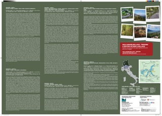
Salice Blu menu Santa Pasqua
Salice Blu menu Santa PasquaSalice Blu menu Santa Pasqua
Salice Blu menu Santa Pasqua
 
What to see and do in and around Bellagio 2019
What to see and do in and around Bellagio 2019What to see and do in and around Bellagio 2019
What to see and do in and around Bellagio 2019
 
Bellagio info 2019
Bellagio  info 2019Bellagio  info 2019
Bellagio info 2019
 
Accommodation Bellagio 2019
Accommodation Bellagio 2019Accommodation Bellagio 2019
Accommodation Bellagio 2019
 
Trekking Bellagio
Trekking Bellagio Trekking Bellagio
Trekking Bellagio
 
Guida turistica
Guida turisticaGuida turistica
Guida turistica
 
Map centre Bellagio
Map centre BellagioMap centre Bellagio
Map centre Bellagio
 
Accommodation Bellagio
Accommodation BellagioAccommodation Bellagio
Accommodation Bellagio
 
Bellagio info 2018
Bellagio info 2018Bellagio info 2018
Bellagio info 2018
 
Brochure Promobellagio
Brochure PromobellagioBrochure Promobellagio
Brochure Promobellagio
 
Bellagio info
Bellagio infoBellagio info
Bellagio info
 
Bellagio information 2014
Bellagio information 2014Bellagio information 2014
Bellagio information 2014
 
Bellagiodove 2013
Bellagiodove 2013Bellagiodove 2013
Bellagiodove 2013
 
Brochure promobellagio eng.con bls
Brochure promobellagio eng.con blsBrochure promobellagio eng.con bls
Brochure promobellagio eng.con bls
 
Brochure bellagio
Brochure bellagioBrochure bellagio
Brochure bellagio
 
Brochure PromoBellagio
Brochure PromoBellagioBrochure PromoBellagio
Brochure PromoBellagio
 

Trekking Bellagio

  • 1. Sentiero 1 - Route 1 Guggiate - Brogno - Rovenza - Parco S. Primo - Bocchetta Terrabiotta Dislivello in salita: 1155 mt - Tempo totale impiegato: 4h 00 min - Difficoltà: E = escursionistico facile. Elevation gain: 1155 m - Total time: 4h - Difficulty: E = easy hike Dal borgo di Bellagio si percorre per un chilometro e mezzo la strada Provinciale costiera per Como (anche servizio bus) e si raggiunge la frazione di Guggiate ove inizia il sentiero 1. Dalla piazzetta della chiesetta di S Andrea in Guggiate si imbocca la via Ciceri, a destra dello scenografico portale di Villa Ciceri, che attraversa la borgata fino ad superare il torrente Perlo (a sinistra resti di allevamenti di trote e di antica filanda). Dopo il ponte si imbocca una scalinata che sale fino ad incrociare una strada asfaltata, girare a sinistra e proseguire in salita fino a superare la piazzola dell’elisoccorso e un cascinale che domina i pascoli e i frutteti di Cagnanica. La strada finisce ed inizia una mulattiera che sale fra muretti rivestiti di edera; al termine della salita girare a sinistra in direzione Perlo (la deviazione a destra porta in 15 minuti alla frazione Vergonese ). Dopo circa 200 metri girare a destra per la mulattiera che sale superando le ultime villette, una cascina e, dopo alcuni tornanti in un fitto castagneto, raggiunge la località Begola con due cascine su un ripiano erboso. La traccia del sentiero si allarga ora in una sterrata che sale in lieve pendio fra boschi e prati fino a costeggiare il parco di Villa Mariani per arrivare alla località Brogno (597m.s.l.m - 1 ora). Il nostro itinerario prosegue, segnavia 1, deviando a destra fra le case in direzione Rovenza e si sale lungo una carrareccia. Al termine della salita si sbuca in una radura con una isolata cappelletta, (a destra inizia il sentiero alternativo 1A che porta a Paum attraverso i boschi lungo il tracciato della antica mulattiera) proseguire diritto lungo la sterrata fra radure e prati terrazzati fino all’abitato di Rovenza. Inizia ora la strada asfaltata che sale a destra che termina dopo circa 2,5 chilometri alla località Paum; oltrepassare il cancello e proseguire lungo il sentiero che sale in un bosco di faggi fino a sbucare nei pascoli dell’Alpe delle Ville. Il sentiero, dopo aver attraversato i prati, arriva ad un cancello e ad un strada sterrata. Girare a sinistra, oltrepassare la costruzione della vecchia Colonia Bonomelli e proseguire in piano fino alla strada asfaltata e ai parcheggi del parco Monte S. Primo (1100m.s.l.m - 3 ore 20 minuti). Qui si segue sulla destra (segnavia 1) la strada asfaltata che conduce all’Alpe del Borgo attraverso i prati che costituiscono le piste da sci del Forcella. Giunti all’Alpe si salgono, tenendo la destra, nel pascolo le tracce di sentiero retrostanti l’edificio fino ad imboccare una stradina sterrata verso destra che entra in un bosco di faggi. In pochi minuti si giunge ad una bocchetta (dalla quale è possibile anche fare una deviazione a sinistra e salire in 10 minuti al Monte Forcella, stazione di arrivo di impianti da sci. Dalla bocchetta si sale a destra lungo un sentiero che sale i prati lungo la cresta. Terminato il prato si può scegliere se seguire la traccia in diagonale a mezza costa attraverso un bosco di ontani cresciuto su una vecchia pista da sci e che arriva alla bocchetta di Terrabiotta (1375 m.s.l.m. – 4 ore) oppure proseguire verso la cima del Monte Ponciv (1453 m.s.l.m.), dove è presente una costruzione con antenne. Follow the provincial lakeside road for Como from the village of Bellagio for one and a half kilometres (you can also take the bus) until you come to the hamlet of Guggiate where Route 1 begins. From the little square in front of the Church of Sant’ Andrea in Guggiate take via Ciceri, to the right of the striking portal of Villa Ciceri. This crosses the hamlet until it passes the Perlo stream (to the left are the remains of trout breeding farms and an old spinning mill). After the bridge, take the steps up to cross over an asphalt road, turn left and continue walking uphill to pass the helicopter rescue pad and the farmstead that overlooks the pastures and orchards of Cagnanica. The road ends and a mule track starts to ascend, bordered by low, ivy-covered walls. At the end of the uphill stretch, turn left towards Perlo (the detour to the right leads to the hamlet of Vergonese after a 15 minute walk – trail sign 15). After about 200 metres turn right onto the uphill mule track which passes the last small villas and a farmstead and, after a few sharp turns in a dense chestnut wood, arrives in the area of Begola, with two farmsteads on grassy level ground. The trail now widens into an unpaved route, which ascends gently between woods and pastures until it borders the grounds of Villa Mariani and comes to the area of Brogno .The route continues, following trail sign 1, deviating to the right between the houses towards Rovenza where you ascend along a cart track. At the end of the uphill, you emerge in a clearing with an isolated little chapel (on the right starts trail 1A, which will take you to Paum through the wood, along the old mule track), then continue straight along the unpaved road between clearings and terraced meadows until you come to the village of Rovenza. Now begins an asphalt road to the right, which leads uphill for around 2.5 kilometres to the area of Paum. Go through the gate and continue along the trail that goes uphill through a beech wood, until you emerge in the pastures of Alpe delle Ville. After having crossed the meadows the trail comes to a gate and an unpaved road. Turn left, passing the old Bonomelli building and continue on the flat until you reach the asphalt road and the car parks of the Mount S. Primo park .Here veer right (trail sign 1) to follow the asphalt road that leads to the Alpe del Borgo.When you reach the alp, continue to follow the trail uphill to the right through the pasture, behind the building, until you come to a small unpaved road towards the right that enters a beech wood. In a few minutes you will reach a saddleback, where you can also make a detour to the left and walk 10 minutes uphill to Monte Forcella. From this saddleback, go right uphill along a trail through the meadows along the crest. When the meadow ends you can choose whether to follow the trail diagonally between the lake shore and the hilltop through an alder wood that has grown on an old ski slope and that leads to the bocchetta di Terrabiotta, or continue towards the peak of Monte Ponciv (1453 m above sea level), where there is a building with an antenna. Sentiero 16 - Route 16 Vassena - Civenna - piano Rancio - Alpe Spezzola Dislivello in salita: 1150 mt - Tempo totale impiegato: 3h 40 min - Difficoltà: E = escursionistico medio. Il sentiero può essere scivoloso, necessitano calzature adatte. Elevation gain: 1150 m - Total time: 3h 40 min - Difficulty: E = medium difficulty hike. The route may be slippery. Use suitable footwear. Vassena è una frazione del Comune di Oliveto Lario, raggiungibile con autobus linea Lecco - Bellagio o con battello che collega Lecco con Bellagio. Dalla piazza della chiesa (interessante il porticciolo), tenendo la destra si sale in via Roma, si attraversa la provinciale, si imbocca di fronte via Carcano e si prende a destra. Dopo un piccolo parco giochi inizia la salita (attenzione seguire le frecce per “Civenna” e non quelle per “Civenna 2”). La strada svolta a sinistra e poi a destra e terminato l’asfalto e un breve tratto in cemento, riprende il corso come mulattiera. Si può notare dalla pavimentazione come una volta fosse una via importante. Attraversata una zona boscosa si arriva ad una carozzabile il località Palembri di Civenna. Si sale a destra e ad un bivio si tiene la sinistra. Attraversata la strada provinciale Bellagio - Magreglio (Ghisallo) si passa nel paese (600 m.s.l.m. - 1 ora 30 minuti) salendo per una strada che si trasforma in mulattiera. Usciti dall’abitato e raggiunte le costruzioni dell’acquedotto tenere la destra e proseguire la salita fino a raggiungere Cascina Giacinta. Proseguire sulla destra in piano e girare a sinistra al primo sentiero che sale. Giunti alla piana di Piano Rancio (990 m.s.l.m. - 2 ore 40 minuti), imboccare la strada in piano a sinistra del ristorante Stella Alpina; proseguire fino in fondo ove inizia la salita al Rifugio Anna Maria. Tenere la destra e prima del rifugio salire nel prato verso sinistra a costeggiare una recinzione. Girare a sinistra in piano nel bosco fino a raggiungere un vecchio impianto Skilift, salire, inoltrarsi nel bosco, superare la valletta e salire sul versante destro orografico del torrentello. Il sentiero prosegue con media salita nel bosco fino a sbuccare nei prati del versante sud-est del Monte Poncivo. Si incontra il sentiero che N. 2 che proviene sulla sinistra da S. Primo. Proseguire a mezza costa aggirando in piano il pendio fino a raggiungere la strada sterrata (sentiero1 = dorsale Brunate-Bellagio). Girando a sinistra si scende all’Alpe Spezzola e poi alla colma di Sormano, girando a destra si raggiunge la bocchetta di TerraBiotta, la vetta del S. Primo o si scende a S. Primo Parco. Vassena is a hamlet in the municipality of Oliveto Lario, which you can reach by bus on the Lecco-Bellagio route or by boat from Bellagio to Lecco. From the church square walk along the lakeshore and take Via Macchiavelli, cross the provincial road, take via Carcano opposite and then go right. The uphill begins on the left(follow the arrows for “Civenna” and not “Civenna 2”). The road at the end of the asphalt and a short stretch in cement continues as a mule track. You can see from how it is made that is was once an important road. Cross a wooded area to reach a carriage road in the Palembri area of Civenna. Go uphill to the right, take via San Vincenzo and then left in via Grèe. Once you reach the village, cross the Bellagio - Magreglio (Ghisallo) provincial road, take via Frassi and go uphill though via Formicosa; when you reach the wash house turn left into via Dante Alighieri. Once you leave the hamlet and reach the aqueduct, turn right and continue uphill to the Giacinta farmstead. Continue to the right on the flat and turn left at the first trail leading uphill. When you reach the Piano Rancio plain, take the level road to the left of the Stella Alpina restaurant and continue to the end until you reach the trail uphill to the Anna Maria Refuge. Keep right and go up the meadow towards the left before the refuge, next to a fence. Turn left on the flat into the wood until you come to an old ski lift, ascend, enter the woods, pass the little valley and ascend the right hand side of the small stream. The trail continues with a semi-steep uphill into the wood until it emerges in the meadows on the south-east side of Mount Ponciv. Here it meets Route 2 from S. Primo on the right Continue on the right until you come to the unpaved road that goes from Colma di Sormano to the peak of s. Primo; you are now on Route 1.You can now decide whether to turn left to descend to Alpe Spezzola and then reach the Colma di Sormano, or turn right to reach the Bocchetta di Terrabiotta , the peak of S. Primo or to descend to the S. Primo Park. Sentiero 2 - Route 2 Visgnola -Belvedere Makallè - Chevrio - Regina Pacis - Cascina Giacinta - Pietra Lentina - Parco monte S. Primo – Alpe Spezzola Dislivello in salita: 1040 mt - Tempo totale impiegato: 4h 45 min - Difficoltà: E = escursionistico facile. Elevation gain: 1040 m - Total time: 4h 45 min - Difficulty: E = easy hike Si lascia l’auto nella piazza della chiesa di Visgnola, a due chilometri dal borgo di Bellagio. (Visgnola è anche raggiungibile con servizio autobus - linea per Lecco). Uscendo dalla piazza con direzione ovest, si risale la provinciale via Valsassina direzione Ghisallo -Erba e dopo 80 m. si imbocca una scalinata sulla sinistra (segnavia 2). Il sentiero prosegue in ripida salita nel prato e nel bosco, seguire i segnavia bianco-rosso. Si sbuca dal bosco e giunti a Cascina Elisa fare attenzione al sentiero che devia, in piano, verso sinistra; dopo circa 100 m girare a destra e risalire il prato seguendo l’indicazione Chevrio. Superate alcune facilissime roccette si giunge ad una sterrata da imboccare in salita. Costeggiare la recinzione verde a sinistra e poi il muro di cinta, dopo 400 m sulla destra affacciatevi al belvedere del Makallè (581 m.s.l.m. - 55 min.) e godetevi una meravigliosa vista sul centro Lago di Como. Proseguendo sulla strada sterrata, superate la Trattoria Baita - Belvedere (bel panorama) e scendete fino al borgo di Chevrio. Superate la cappelletta e la fontana salendo dritto lungo la strada asfaltata arrivate alla provinciale, girare a destra e scendere per circa 200 metri. Al N. civico 206 girare a sinistra e imboccare una sterrata che è costeggiata da recinzioni. (segnavia 3) Si prosegue in salita, superando delle ville e l’agglomerato di Cascine Gallasco, fino a sbucare sulla provinciale all’altezza della chiesina Regina Pacis (696 m.s.l.m. - 1 ora 45 minuti). Girando a sinistra lungo la provinciale (direzione villa Mora) si arriva all’imbocco (a destra) di via Mora, una strada asfaltata in salita. Si prosegue fino in fondo dove la strada finisce in corrispondenza di una cascina (con affresco di una Madonna). Il sentiero prosegue sulla sinistra in falso piano costeggiato da cespugli. Si sbuca poi al Munt del Mot - cascina Dalcò, dove al bivio si gira a sinistra, fino alla mulattiera che proviene da Civenna ove si gira a destra. Proseguendo lungo la mulattiera, e si giunge alla cascina Giacinta ove una fontana potabile vi permetterà di dissetarvi. Si prosegue lungo il sentiero che si inoltra nel bosco e con leggera salita, si superano dei cancelli fino a pervenire, con un ultimo strappo del sentiero, alla Pietra Lentina, il masso erratico più grande del triangolo Lariano. (Volendo è possibile, a metà percorso, deviare a sinistra verso PietraLuna / Pian Rancio). Di fronte alla Pietra Lentina, a sinistra, dalla strada Provinciale sale un sentiero nella pineta che prosegue a mezza costa fino a sbucare, in prossimità di un palo dell’ Enel, nel parcheggio dell’ Albergo Genzianella - Parco Monte S. Primo (1100 m.s.l.m. - 3 ore 20 minuti), sulla provinciale che sale da Pian Rancio. Superato l’albergo si prende la strada che sale a sinistra e, superato il bivio si prosegue nel bosco inoltrandosi lungo una sterrata. La strada si trasforma in sentiero che scende leggermente fino ad una casetta; superata la casetta (capanna Maria) prendete il sentiero che sale a destra (il sentiero che scende a sinistra porta al rifugio AnnaMaria di Piano Rancio). Proseguite salendo nel bosco di faggi, superate la bella vecchia neviera circondata da faggi secolari e passate alti sopra le case abbandonate dell’Alpe di Magreglio. Il sentiero sale dolcemente con alcune curve e tenersi sulla sinistra fino a raggiungere la forcella ove si incontra il sentiero 1 che sale da S. Primo. State bassi a sinistra e proseguite nel bosco a mezza costa fino a quando superate alcune vallette, si sbucca in un prato ove si incontra il sentiero 16 che dalla sinistra sale da Piano Rancio. Proseguite girando sulla destra fino ad incontrare la strada sterrata che unisce la Colma di Sormano con la vetta del S. Primo; siete sulla dorsale Brunate / Bellagio - Sentiero 1 (1307 m.s.l.m. - 4 ore 45 minuti). Leave your car in the church square in Visgnola, 2 kilometres from the village of Bellagio (you can also reach by Visgnola by bus, on the route to Lecco or Asso). Leave the square heading west and return along the provincial road (via Valsassina) towards Ghisallo – Asso - Erba. After 80 m, take the steps on your left (trail sign 2). The route leads steeply uphill through the meadows and wood, following the red and white trail sign. When you come out of the wood and reach the Elisa Farmstead, pay attention to the trail, which deviates, on the flat, towards the left. After around 100 m turn right and go back through the meadow, following the sign for Chevrio. After climbing over some very easy low rocks, you come to an unpaved road, which you follow uphill. Walk besides the green fence on the left and then a retaining wall. After 400 m on the right is the Makallè viewpoint, where you can enjoy a splendid view of the centre of Lake Como. Follow the unpaved road, past the Baita Belvedere restaurant and descend to the hamlet of Chevrio .Pass the little chapel and the drinking fountain, and continue straight up the asphalt road to the provincial road. Turn right and descend for about 200 metres. At house number 206 turn left and take an unpaved road bordered by fences (trail sign 2). Continue uphill, past some villas and the Gallasco farmsteads, until you reach the provincial road at the little Regina Pacis church Turn left onto the provincial road and come to via Mora (on your right), which is an asphalt road leading uphill. Continue to where the road ends at a farmstead (with a fresco of the Virgin Mary). The route continues to the left on a ‘false flat’ bordered by bushes. It then comes out at the Barco farmstead, where you turn left at the fork, leading to a mule track from Civenna where you turn right. Follow this mule track to the Giacinta farmstead where there is a brass tap you can drink from. Follow the trail that continues gently uphill through the woods, passing the gates until you come to the final part of the trail, Pietra Lentina, the largest erratic boulder of the Lake Como triangle (If you wish, half way along the trail, you can make a detour to the left towards PietraLuna / pian Rancio). Opposite Pietra Lentina, to the left, is a trail leading from the provincial road through the pine forest, which continues halfway down the mountain and comes out near an ENEL (electricity board) pole, in the Genzianella Hotel - Mount S. Primo car park along the provincial road leading from Pian Rancio. Keep walking direction S.Primo Mount and 300 meters after passing the hotel, take the road to the left and pass the crossroad continuing into the woods along an unpaved road. The road turns into a path that descends slightly to a little house, pass the house and take the path to the right (the path on the left leads to the Anna Maria Refuge at Piano Rancio). Continue uphill through the beech wood, past the beautiful old ice house surrounded by beech trees and continue high above the abandoned houses of the Alpe di Magreglio. The trail climbs gently with some curves, keep to the left until you reach the fork where you meet Route 1 from S. Primo. Stay low to the left and continue into the woods halfway until after a few valleys, you get into a meadow where you meet Route16 from Piano Rancio to the left. Continue turning right until you reach the unpaved road which connect Colma di Sormano with the top of Monte San Primo, you are on the “Dorsale” Brunate / Bellagio – Route 1. At the crossroad you can choose whether to turn left and descend to Alpe Spessola and then continue to Colma di Sormano or take uphill on the right towards Bocchetta di Terrabiotta from where it is possible to reach the peak of Mount S. Primo or descend to Park s. Primo. Sentiero 27 - Route 27 Bellagio /Visgnola- Civenna-Magreglio/Ghisallo-Conca di Crezzo-Valbrona/ Visino Dislivello in salita: 661 mt - Dislivello in discesa: -454 mt - Tempo totale impiegato: 4h 30 min. - Difficoltà: E = escursionistico facile. Il sentiero può essere scivoloso, necessitano calzature adatte. Elevation gain: 661 m – Elevation loss: -454 m - Total time: 4h 30 min. - Difficulty: E = easy hike. The trail may be slippery. Use suitable footwear. Si lascia l’auto nella piazza della chiesa di Visgnola, a due chilometri dal borgo di Bellagio (Visgnola è anche raggiungibile con servizio autobus - linea per Lecco). Uscendo dalla piazza con direzione ovest, si risale la provinciale via Valsassina direzione Ghisallo - Erba e dopo 80 m. si imbocca una scalinata sulla sinistra (segnavia 2). Il sentiero prosegue in ripida salita nel prato e nel bosco. Si sbucca dal bosco e giunti a Cascina Elisa fare attenzione al sentiero che devia, in piano, verso sinistra. Proseguire in piano con cautela nel tratto esposto. Il sentiero, dopo una breve discesa e una risalita, raggiunge i pascoli bassi di Chevrio (520 m.s.l.m. - 45 minuti). Si prosegue in piano nei boschi, aggirando vallette fino all’abitato di Limontasca. Risalendo la strada sterrata verso nord/ovest si trova a sinistra l’imbocco del sentiero verso Civenna 2 (580 m.s.l.m. - 1 ora 25 minuti). Si aggira la parte bassa dell’insediamento fino alla vecchia Cascina Gorla ove si prosegue stando bassi sulla destra. Giunti alla mulattiera che arriva nel paese basso di Civenna, si gira a sinistra per percorrere la panoramica via Foschi e, alla cappelletta di Greé si scende verso la Località Palembri (si incrocia il sentiero 16 che sale da Vassena). Attraversato il torrentello si risale nei boschi verso il Campeggio Ghisallo e al santuario del Ghisallo. Giunti alla famosa chiesetta dedicata ai ciclisti, si gira a sinistra e si percorre la strada asfaltata lungo le recinzioni dei giardini. Si prosegue in piano per prati e boschi prima su una sterrata, poi su un sentiero in piano. E’ ora possibile o tenere la destra , scendere sulla strada asfaltata che da Barni sale alla Conca di Crezzo (800 m.s.l.m. - 3 ore 50 minuti), oppure tenere la sinistra per salire al monte Castel de Leves, punto molto panoramico. Scesi verso sud, si passa ove è caduto l’aereo ATR42 e si giunge alla Conca di Crezzo con un vecchio nucleo di abitazioni (in alto sul colle il ristorante Madonnina può soddisfare le esigenze dei più affamati). Dalla conca si percorre un breve tratto in discesa della strada che sale da Lasnigo e si imbocca a sinstra una strada lastricata che sale; a un bivio, a sinistra porta all’Alpe di Monte per poi scendere a Maisano in Valbrona; a destra sale al Monte Megna per poi scendere a Visino in Valbrona (512 m.s.l.m. - 4 ore 30 minuti). Leave your car in the church square in Visgnola, 2 kilometres from the village of Bellagio. (You can also reach Visgnola by bus, on the route to Lecco). Leave the square heading west and return along the provincial road (via Valsassina) towards Ghisallo –Erba. After 80 m, take the steps on your left (trail sign 2). The route leads steeply uphill through a meadow and wood. When you come out of the wood and reach the Elisa Farmstead, pay attention to the trail, which deviates on the flat, towards the left. Continue carefully along the exposed part on the flat. After a short descent and another ascent, the trail brings you to the lower pastures of Chevrio ( 520 m above sea level – 45 min). Continue on the flat into the woods, around little valleys, until you come to the village of Limontasca. Follow the unpaved road back towards the north/west and on your left is the trail towards “Civenna 2”( 580 m above sea level – 1 hour 25 minutes). Go around the lower part of the hamlet to the old Gorla farmstead where you can continue on lower ground on the right. When you reach the mule track that leads to the lower part of the village of Civenna, turn left to follow the panoramic road, via Foschi, and descend towards Palembri at the little chapels of Greé (you will cross Route 16 from Vassena). Cross the little stream to ascend through the woods towards the Ghisallo Campsite and the Ghisallo Sanctuary. When you reach the famous little church dedicated to cyclists, turn left and follow the asphalt road along the garden fences. Continue on the flat across meadows and woods, first on an unpaved road, then on a level road. Now you can either keep right and go down the asphalt road from Barni to the Crezzo valley ( 800 m above sea level – 3 hours 50 min), or keep left to go up Mount Castel de Leves, a very panoramic viewpoint. When you descend towards the south you pass the site of the ATR42 plane crash and reach the Crezzo valley, with its old centre and houses (if you’re hungry you can enjoy a meal high up on the hill at the Madonnina restaurant). From the valley, you follow a short downhill stretch of the road from Lasnigo and take a paved road on your left uphill. At a crossroads, turn left to go to Alpe di Monte and then descend to Maisano in Valbrona; or go right to go up Mount Megna and then descend to Visino in Valbrona ( 512 m above sea level – 4 hours 30 min). Sentiero 5 - Route 5 S. Giovanni - Vergonese - Brogno - CHEVRIO Dislivello in salita: 390 mt - Tempo totale impiegato: 1h 05 min - Difficoltà: E = escursionistico facile. Elevation gain: 390 m - Total time: 1h 5 min - Difficulty: E = easy hike Si lascia l’auto nel parcheggio al parco di S. Giovanni (a due chilometri dal borgo di Bellagio anche raggiungibile con servizio autobus - linea per Como e, durante l’estate, con battello). Si attraversa il borgo di S. Giovanni ove è consigliato visitare la Chiesa parrocchiale e sostare sulla piazza per ammirare il lago e godere il panorama. Dalla piazza della chiesa si imbocca la strada in salita sulla destra del ristorante Mella - Ittiturismo. Dopo circa 100 mt., all’altezza di un crocifisso ottocentesco, purtroppo in stato di scarsa manutenzione, svoltare a destra in via al Crotto. Proseguire e, attraversato un ponticello, imboccare a destra la mulattiera in salita. Arrivati sulla provinciale Bellagio - Como, attraversare la strada, tenere la destra e salire lungo la scala per Via per Vergonese. Si arriva alla chiesetta di Vergonese e si prosegue attraversando le case della frazione. Imboccare la mulattiera in salita tra due muri a secco. Il sentiero sale nella valletta del ruscello di Brogno tra boschi e cespugli fino ad arrivare alla strada sterrata che sale dai Mulini del Perlo (sentiero 1). Girare a destra lungo la sterrata fino alle case di Brogno (597 m.s.l.m. - 50 minuti). Scendere lungo la sterrata e in piano raggiungere e superare la provinciale asfaltata, imboccare sulla sinistra la stradina che sale a Chevrio da cui è possibile rientrare a Bellagio con il sentiero 2 sulla sinistra. Leave your car in the car park in S. Giovanni ,2 kilometres from the village of Bellagio, which you can also reach by bus (the route to Como) and by boat during summer. Walk through the hamlet of S. Giovanni where we suggest you visit the parish church and stop in the square to admire the view over the lake. From the church square take the road up to the right of the Mella – Ittiturismo restaurant. After around 100 m, at a 19th century cross turn right onto via al Crotto. Continue and, after crossing a little bridge, take the mule track uphill on the right. Once you reach the Bellagio - Como, provincial road, cross the road, keep right and go up the steps to Via per Vergonese. You will come to the little church of Vergonese and then continue past the houses in the hamlet. ( on the left the route ( trail sign 15) take to Mulini del Perlo )Take the mule track uphill between two dry stone walls. The trail leads to the little valley of the Brogno stream , amidst woods and bushes, until it meets an unpaved road that leads uphill from Mulini del Perlo (Route 1). Turn right onto the unpaved road until you come to the houses in Brogno. Follow the asphalted road until you come to the small bridge above the stream Perlo and after a while you reach the asphalted provincial road. Following the provincial road after 50 metres, on the left, is a little road that leads up to Chevrio, from where you can return to Bellagio via Route 2 leading uphill on the left. Sentiero 39 - Route 39 Brogno - Belvedere del Nuvolone - Rifugio Martina - Vetta S. Primo - Bocchetta Terrabiotta Dislivello in salita: 1089 mt - Dislivello in discesa: -311 mt - Tempo totale impiegato: 4 ore 15 min. - Difficoltà: EE = escursionistico esperto. Il sentiero può essere scivoloso, necessitano calzature adatte. Alcuni brevi tratti sono esposti o con roccette facili, necessita un po’ di preparazione. Elevation gain: 1089 m – Elevation loss: - 311 m - Total time: 4h 15 min. - Difficulty: EE = for experienced hikers. The trail may be slippery. Use suitable footwear. Some short stretches may be exposed or with easy rocks, which need some prior experience. Imboccare la stradina in salita tra due recinzioni e proseguire fino a trovare sulla sinistra una delimitazione con pali prima di un cancello. Imboccare il sentiero a sinistra che sale nel bosco e proseguire facendo attenzione ai segnavia; il sentiero si snoda con media pendenza attraversando boschi di olmi, aceri, faggi, betulle… Al termine di un tratto ripido si sbucca in una radura da cui è possibile ammirare uno dei più bei panorami del lago di Como, siete arrivati al Belvedere del Nuvolone (990 m.s.l.m. - 1 ora 10 minuti) (la vetta del Monte Nuvolone è a 10 minuti, ma essendo nel bosco e coperta da fitta vegetazione non è di alcun interesse). Proseguite sul versante sinistro - orientale, il sentiero, dopo aver attraversato alcune radure, scende tra facilissime roccette, alla bocchetta di Lezzeno, (in una grotta troverete “La Madonna dei Fungiat”). Superata la bocchetta del Nuvolone (939 m.s.l.m.), ignorate sia il sentiero a destra che scende a Lezzeno che quello a sinistra che scende al sentiero n. 1. Il sentiero 39 prosegue mantenendosi in cresta e superando boschi, radure e le case di Colmenetta ; superato il monte Fopa (1116 m.s.l.m.) e stando sempre sul crinale tenendo la destra, si arriva alla Rifugio Martina (1231 m.s.l.m. - 2 ore 50 minuti). Dal rifugio Martina si prosegue verso la vetta del Monte S. Primo lungo un sentiero a tratti molto impervio e ripido. Dalla vetta del Monte S. Primo (1686 m.s.l.m. - 3 ore 50 minuti) si ammira uno dei più bei panorami che, nei giorni limpidi, spazia dal Monviso, al Rosa, al gruppo Jungfrau, alle alpi Retiche, al Disgrazia e alle Prealpi Lombarde. Ora si può scendere verso sud - est o percorrendo la strada sterrata, o sul sentiero che percorre le creste (attenzione alle ortiche, sono consigliabili pantaloni lunghi) fino alla bocchetta di Terrabiotta dove si incontra il sentiero N. 1. Verso sinistra si scende al Parco Monte S. Primo oppure si prosegue dritto per la dorsale verso Brunate. Leave the car in the hamlet of Brogno, reachable following the Provincial road Bellagio-Magreglio and then following the paved road which lies between two pillars. (The town of Brogno is also accessible from Bellagio with bus service to Asso, getting off at the request stop situated right near the two pillars and then walking along the paved road which, past the stream Perlo with a beautiful bridge stone, comes to the houses of Brogno after less than a kilometer). When the climb finishes rather than go to the right, take the road that goes between two fences on the left and continue until you come to a delimitation marked by poles on the left before a gate. Take the trail to the left that goes uphill into the wood and continue, following the trail sign. The trail winds, with a medium-steep slope, through elm, maple, beech and birch woods. At the end of a steep stretch you come to a clearing where you can see one of the loveliest views of Lake Como at the Nuvolone viewpoint (the peak of Mount Nuvolone is 10 minutes away, but is not particularly interesting, as it is in a wood covered by dense vegetation). Continue along the left (eastern) side and after crossing several clearings the trail descends between some easy rocks to the Bocchetta del Nuvolone, (where you will find the “Virgin Mary dei Fungiat” in a grotto). Pass the Nuvolone saddleback (939 metres above sea level) ignoring both the trail on the right that descends to Lezzeno and the one on the left that descends to Route 1. Route 39 continues along the crest, past woods, clearings and the houses of Colmenetta, past Mount Fopa . Keep right along the ridge to arrive at the Martina mountain refuge- Alpe dei Picet. From the Martina mountain refuge the trail continues towards the peak of Mount S. Primo. The trail has some very arduous and steep stretches. From the peak of Mount S. Primo you can see one of the loveliest views, which on a clear day, stretches from Monviso, to Mount Rosa, the Jungfrau group, the Rhaetian Alps, the Disgrazia and the Prealps of Lombardy. Now you can descend towards the southeast on the unpaved road, or via the trail that runs along the crest (beware of nettles: wear long trousers) until the Bocchetta di Terrabiotta where you join Route 1. To the left you can descend to the Mount S. Primo Park or continue straight along the ridge towards Brunate. WALK AROUND BELLAGIO - TREKKING E SENTIERI INTORNO A BELLAGIO Sentieri ed escursioni da sogno (guida pratica con percorsi e mappa) WALK AROUND BELLAGIO - TREKKING and routeS near BELLAGIO Wonderful paths and hiking (practical guide with routes and map) COME ARRIVARE - HOW TO REACH BELLAGIO IN AUTO Superstrada per Sondrio prima di Lecco uscire seguendo indicazioni per Bellagio; Autostrada Laghi A9 Milano-Lugano e uscire a Como IN AEREO Linate/Malpensa Tel. 02.74852200 Orio al Serio (BG) Tel. 035.326323 IN TRENO Train from Milano to Como lenord.it Train from Milano to Lecco/ Varenna trenitalia.it IN TRAGHETTO Boat and ferry on Lake Como: navigazionelaghi.it AUTOBUS Lecco-Visgnola lineelecco.it ASF verso Asso asfautolinee.it Bellagio-Como sptlinea.it INFORMAZIONI E PRENOTAZIONE STRUTTURE RICETTIVE: INFORMAZIONI TURISTICHE, EVENTI E SPORT: PROMOBELLAGIO www.bellagiolakecomo.com Piazza della Chiesa, 14 22021 Bellagio (Como) Tel. e fax +39.031.951555 info@promobellagio.it BELLAGIO LIFESTYLE www.bellagiolifestyle.it facebook.com/bellagiolifestyle twitter.com/bellagiolife youtube.com/bellagiolifestyle AUTOAMBULANZA - Tel. 118 Volontari di Bellagio - Tel. +39 031.950000 CARABINIERI Tel. 112 Caserma Bellagio Tel. +39 031.950353 POLIZIA MUNICIPALE c/o Municipio Tel. +39 031.951110 NUMERI UTILI - USEFUL NUMBERS: TAXI: AUTONOLEGGIO FANTONI Tel. +39.339.388.72.38 BARINDELLI Tel. +39.031.950.326 BELLAGIO TAXI SERVICE Tel. +39.328.064.93.28 CLAUDIO SANCASSANI Tel. +39.335.629.95.88 retro cartina_2014.indd 1 18/06/14 23.32