1. Marine Sector
3D Laser scanning & 3D
modelling for Marine Sector
Severn Partnership have been developing skills in 3D laser
scanning since 2003 and scanning & modelling for the marine
industry since 2009. So combining our RICS Chartered status
with an established quality system (audited by BSI) and state
of the art Leica HDS scanning equipment we are able to offer a
comprehensive service to the Marine sector.
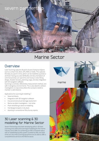
Overview
Laser Scanning captures 3D point clouds of physical objects
such as a ship’s Hull, deck, GPS, ROVs or holds. This captures
the data at a point in time, which can be modelled, queried or
archived. Having accurate 3D Modles and documentation of
commercial ships can save time and money in retro fitting
design, disaster recovery, planning cargo, and also integration
with 3D navigation software.
Scanning is a remote, reflectorless measurement method, and
safe in dangerous environments. This is also ideal for collision
investigation or snap zones where the surveyors needs to
maintain a safe distance.
Applications for scanning & modelling ?
• Naval architects
• Integration with 3D navigation software
• Insurance & structural damage assessment
• Marine accident investigators – hull strike
• Plant retrofitting or deck re-modelling
• Hull design & repairs in dry dock
• Assisting in conventional Ship Survey reports
2. Severn Partnership have provided marine
laser scanning, 3D modelling & visualisation
solutions for Global Marine Systems on the
following vessels and projects:
• Canal Trust, Survey of Historic Barges and Locks
• CS Sovereign, 130m (Cammel Laird)
• Cable Innovator, 145m (Hong Kong Harbour)
• Wave Venture – Visualisation
• Wave Sentinal - Visualisation
• Jan Steen 77m with lifting crane
• London Array, wind turbine project
• ROVs and other seabed equipment
Case Study
Racing Yachts – 3D Laser Scan & 3D CAD
Model Summary:
Ship and yacht hulls are the ideal project for 3D laser scanning
and 3D CAD modelling. Their uniqueness and complex curved
features mean conventional survey techniques can often
become difficult. By using the latest Leica P20 3D laser scanner
Severn were able to scan 7 heritage racing yachts with 1 day on
site.
In detail:
Each yacht was scanned in isolation from 5 to 6 set-ups to
ensure full coverage over the hull. Critical points on each yacht
were identified in each scan and used for hull analysis. One
yacht was also scanned internally to create a complete point
cloud. The completed point clouds were then used to create
2D sections and a 3D CAD model for use in analysis software
to compute wetted surface area, waterline length and righting
moment.
Deliverables:
• 3D laser scanned point cloud (PTS, PCG & POD)
• 2D CAD Plans, sections, elevations
• 3D Revit models (RVT & IFC)
• Leica TruVIews
The Maltings 59,
Lythwood Road,
Bayston Hill,
Shrewsbury,
Shropshire.
SY3 0NA
Tel. 0844 880 8247
Fax: 0844 880 8248
webenquiry@severnpartnership.com
www.severnpartnership.com
Quality data measured safely delivered professionally on time