Geophysical techniques work through applying one of several types of force to the ground, to measure the
resulting energy with use of geophysical equipment and infer the geology from this. Geophysics is generally
much quicker than the aforementioned methods, however, requires more data processing (oìce-based work)
to develop the geological picture. A great advantage of these methods is that certain instruments can be
attached to small aircraft for covering large areas during regional airborne surveys. This provides sparser
geological information, but can highlight potential metal anomalies on a county-country scale, which can be
followed up by more detailed, ground-based geophysical surveys. However, as the material is being tested
indirectly, there is no 100% guarantee of its conclusions; in addition to being susceptible to contamination by
many man-made metallic structures e.g. power-lines. Therefore, should geophysical surveys prove suìciently
interesting, drilling will be required afterwards to conêrm the accuracy of the results.
chapter 5.pptx: drainage and irrigation engineering
Geophysical methods
1. 12/31/21, 12:04 PM Geophysical Methods
https://www.gsi.ie/en-ie/programmes-and-projects/minerals/activities/mineral-exploration/Pages/Geophysical-Methods.aspx 1/7
Geological Survey Ireland (https://www.gsi.ie/en-ie) Programmes & Projects (https://www.gsi.ie/en-ie/programmes-and-
projects) Minerals (https://www.gsi.ie/en-ie/programmes-and-projects/minerals) Activities (https://www.gsi.ie/en-
ie/programmes-and-projects/minerals/activities) Mineral Exploration, how it's done (https://www.gsi.ie/en-ie/programmes-
and-projects/minerals/activities/mineral-exploration) Geophysical Methods
Geophysical Methods
Geophysical techniques work through applying one of several types of force to the ground, to measure the
resulting energy with use of geophysical equipment and infer the geology from this. Geophysics is generally
much quicker than the aforementioned methods, however, requires more data processing (office-based work)
to develop the geological picture. A great advantage of these methods is that certain instruments can be
attached to small aircraft for covering large areas during regional airborne surveys. This provides sparser
geological information, but can highlight potential metal anomalies on a county-country scale, which can be
followed up by more detailed, ground-based geophysical surveys. However, as the material is being tested
indirectly, there is no 100% guarantee of its conclusions; in addition to being susceptible to contamination by
many man-made metallic structures e.g. power-lines. Therefore, should geophysical surveys prove sufficiently
interesting, drilling will be required afterwards to confirm the accuracy of the results.
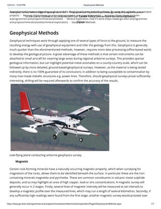
Low-flying plane conducting airborne geophysics survey.
Certain rock-forming minerals have a naturally occurring magnetic property, which when surveying for
magnetism of the rocks, allows them to be identified beneath the surface. In particular these are the iron-
containing minerals magnetite and pyrrhotite. These are common constituents in volcanic metal sulphide
deposits, and so may highlight an area of high copper, lead or zinc concentrations. A magnetic survey will
generally occur in 2 stages. Firstly, several lines of magnetic intensity will be measured at set intervals to
develop a magnetic profile over the measured lines, which may run a length of several kilometres. Secondly, if
any sufficiently high readings were found from the first stage, another magnetic survey would proceed over
Magnetic
Important information regarding cookies and the Geological Survey Ireland website. By using this website, you consent
to the use of cookies in accordance with our Cookie Policy (/en-ie/more-on-us/compliance).
Close
2. 12/31/21, 12:04 PM Geophysical Methods
https://www.gsi.ie/en-ie/programmes-and-projects/minerals/activities/mineral-exploration/Pages/Geophysical-Methods.aspx 2/7
the areas of interest, but this time over a grid pattern as opposed to lines. This latter stage allows a more
detailed understanding of the magnetic intensity of the area, and from this work a map can be produced
showing the magnetic intensity of the underlying rocks.
Magnetic surveys are conducted using equipment called a magnetometer, which can be operated manually as
a handheld version for geologists in the field, or attached to planes for larger regional surveys. The instrument
works in the form of a proton-rich fluid surrounded by an electric coil. A current is applied through the coil to
polarise the fluid. When the current is switched off, the protons realign along the Earth's magnetic field at that
position. Magnetic surveys have several important uses outside of mineral exploration including archaeology
and locating steel and iron man-made structures beneath the surface, including looking for underground
mineshafts from historic mines. This method allows deep penetration and is unaffected by high electrical
ground conductivities, making them useful at sites with saline groundwater, clay or high levels of
contamination where other geophysical methods struggle.
EM surveys differ from magnetic surveys in that as opposed to relying on the signature of naturally high
intensity magnetic minerals, it induces an electromagnetic current into the ground and measures the resulting
field. Because it is not limited to the presence of magnetite and pyrrhotite, it is useful for exploring for a wide
range of metallic minerals, including important metals such as cobalt which is used in batteries for renewable
energy sources. .
The EM system consists of a transmitter and receiver coil which is suspended above the ground. A primary
electromagnetic field is output by the transmission coil which induces a secondary field in the ground – the
magnitude of which is measured by the receiving coil which also measures the ratio between the primary and
secondary fields. The magnitude of the secondary field is proportional to the conductivity of the material and
can be used to detect signs of changes in rock type, potential mineralisation, groundwater, ground
contamination and buried metal man-made objects. Similar to magnetic surveys, EM is conducted on a grid of
sampling points at set intervals.
Electrical resistivity, also known as resistivity, is a bulk electric property of all material that shows how strongly
it opposes the flow of electric current. A low resistivity indicates a material that readily allows the flow of
electric current – i.e. it is conductive. All materials have a certain resistivity and fall within a broad range. The SI
unit for resistivity is the ohmmeter (Ωm). Resistivity surveys can allow for imaging the subsurface of the Earth
on both land and in water, with scans in either 2D sections or 3D volumes of rock. It is used by applying a
small and highly controlled electric current across an array of electrodes, and so resistivity surveys are often
coupled with induced polarisation surveys as the latter also make use of such electrodes.
Because of the conductive properties of various metal-bearing minerals, resistivity can be used in mineral
exploration for metallic ore bodies. However resistivity is an important method for many other studies
including geotechnical and groundwater exploration. For example, geologists can use resistivity imaging to
create a time-lapse of biological or hydrological events over time, to capture % change of dynamic conditions
e.g. examining how water discharges underground, or see how dangerous chemical spillages are moving
underground.
Electromagnetic (EM)
Electrical Resistivity
Important information regarding cookies and the Geological Survey Ireland website. By using this website, you consent
to the use of cookies in accordance with our Cookie Policy (/en-ie/more-on-us/compliance).
Close
3. 12/31/21, 12:04 PM Geophysical Methods
https://www.gsi.ie/en-ie/programmes-and-projects/minerals/activities/mineral-exploration/Pages/Geophysical-Methods.aspx 3/7
Important information regarding cookies and the Geological Survey Ireland website. By using this website, you consent
to the use of cookies in accordance with our Cookie Policy (/en-ie/more-on-us/compliance).
Close
4. 12/31/21, 12:04 PM Geophysical Methods
https://www.gsi.ie/en-ie/programmes-and-projects/minerals/activities/mineral-exploration/Pages/Geophysical-Methods.aspx 4/7
Geologist conducting a resistivity-IP survey.
IP is the Earth's capacity to hold an electric charge over time. It is measured through inducing a current into
the ground, then switching it off and measuring how the voltage decays over time, usually a matter of
seconds, eventually disappearing. Where resistivity answers "What is the resistance to the flow of electric
current?" IP answers "How long do the rocks hold an electric charge?" IP often uses the same cable setup and
same instrument as resistivity surveys, but instead turns off the current and measures the time component. It
uses electrodes.
This method is important because it tests for the capacity of rocks to hold charge and hence properties in the
subsurface that can be used to locate clay and other chargeable minerals. Usually these surveys are very
informative for determining rocks because you end up with both an IP and resistivity map at the same time,
allowing both measurement types to be interpreted. It is therefore important for mineral exploration, as
sulphide minerals – including those hosting gold, silver and copper, generate a very large IP signature. This is
especially useful when the metal-bearing minerals are more loosely distributed within the rock – as opposed
to forming a concentrated ore body. IP also is a useful tool in environmental work e.g. mapping a zone of
contamination to help clean-up.
Seismic surveys are an extremely useful geophysical method for studying the ground conditions to a
significant depth and over a large area. Seismic is utilised in many applications for subsurface investigations,
mineral exploration being one of them. The method operates by emitting a percussive force to the ground,
producing seismic waves which travel through the subsurface, reflecting back or refracting each time a
structure of geological boundary is encountered. Thus from this, the depth and shape of underground
structures can be interpreted from seismic profiles. The initial force can be generated by means of explosives,
or in environmentally sensitive areas (i.e. anywhere on land) dropping a significant weight onto the ground
surface using a hammer-plate or buffalo gun. Refracted waves are detected by an array of geophones which
are spaced at regular intervals. The geophones record the time taken by direct waves, reflected waves and
refracted waves and outputs this data to a seismograph for processing so it can be interpreted for
underground structures. Analysing the time that the soundwaves take to return provides valuable information
about rock types and possible fluids in the rocks, and is similar to the use of ultrasound in medicine.
Induced Polarisation (IP)
Seismic
Important information regarding cookies and the Geological Survey Ireland website. By using this website, you consent
to the use of cookies in accordance with our Cookie Policy (/en-ie/more-on-us/compliance).
Close
5. 12/31/21, 12:04 PM Geophysical Methods
https://www.gsi.ie/en-ie/programmes-and-projects/minerals/activities/mineral-exploration/Pages/Geophysical-Methods.aspx 5/7
Diagram illustrating the principles of seismic exploration.
Onshore seismic surveys have been used in sensitive urban locations without damaging buildings or the
environment, e.g. its use in central Paris. More than four decades of offshore seismics and numerous research
projects have shown the majority of evidence pointing towards such surveys having negligible effects on
marine environments. A case study example of this is the rise of whale populations in Australia on both coasts,
where both are near their biological maximum (10% per year), despite a significantly greater amount of
offshore seismics on the West coast than the East.
Radiometric surveys (also known as Gamma ray spectrometry) are an airborne method which measures the
amounts of natural radiation produced at the Earth's surface. Radioactive uranium, thorium and potassium
minerals occur naturally in rocks, producing relatively high amounts of radiation which can be measured in
contrast to the surrounding rocks. Due to gamma radiation only being able to penetrate several centimetres
of earth/ground, the radioactive materials must be present in outcrops to be detected. However, through
atmosphere, these rays can penetrate up to a couple of hundred metres, and so low-flying aircraft are useful
in this method for covering large regional areas. Because the energy of gamma radiation received is distinctive
of the specific element, it can be used to map uranium-thorium-potassium concentrations over wide areas.
This in turn is used to infer rock types such as granite and zones within rocks that may have been altered by
Radiometric
Important information regarding cookies and the Geological Survey Ireland website. By using this website, you consent
to the use of cookies in accordance with our Cookie Policy (/en-ie/more-on-us/compliance).
Close
6. 12/31/21, 12:04 PM Geophysical Methods
https://www.gsi.ie/en-ie/programmes-and-projects/minerals/activities/mineral-exploration/Pages/Geophysical-Methods.aspx 6/7
metal-rich fluids passing through. It is extremely important to note that these surveys measure levels of
naturally occurring radiation in the rocks, and the instruments themselves do not emit any radiation, making
them harmless to both people and livestock.
Programmes & Projects
Geoenergy (/en-ie/programmes-and-projects/geoenergy/Pages/default.aspx)
Geohazards (/en-ie/programmes-and-projects/geohazards/Pages/default.aspx)
Geoheritage (/en-ie/programmes-and-projects/geoheritage/Pages/default.aspx)
Geological Mapping (/en-ie/programmes-and-projects/geological-mapping/Pages/default.aspx)
Geoscience Ireland (/en-ie/programmes-and-projects/geoscience-ireland/Pages/default.aspx)
Groundwater and Geothermal (/en-ie/programmes-and-projects/groundwater-and-geothermal-
unit/Pages/default.aspx)
Information (/en-ie/programmes-and-projects/information/Pages/default.aspx)
Marine and Coastal (/en-ie/programmes-and-projects/marine-and-coastal-unit/Pages/default.aspx)
Minerals (/en-ie/programmes-and-projects/minerals/Pages/default.aspx)
Projects (/en-ie/programmes-and-projects/minerals/projects/Pages/default.aspx)
Activities (/en-ie/programmes-and-projects/minerals/activities/Pages/default.aspx)
Mineral Exploration (/en-ie/programmes-and-projects/minerals/activities/mineral-exploration/Pages/default.aspx)
Geological Mapping (/en-ie/programmes-and-projects/minerals/activities/mineral-exploration/Pages/Geological-
Mapping.aspx)
Soil Sampling (/en-ie/programmes-and-projects/minerals/activities/mineral-exploration/Pages/Soil-Sampling.aspx)
Stream Sediments (/en-ie/programmes-and-projects/minerals/activities/mineral-exploration/Pages/Stream-
Sediments.aspx)
Drilling (/en-ie/programmes-and-projects/minerals/activities/mineral-exploration/Pages/Drilling.aspx)
Geophysical Methods (/en-ie/programmes-and-projects/minerals/activities/mineral-
exploration/Pages/Geophysical-Methods.aspx)
Mineral Exploration in Ireland FAQs (/en-ie/programmes-and-projects/minerals/activities/mineral-
exploration/Pages/FAQs.aspx)
Representation (/en-ie/programmes-and-projects/minerals/activities/Pages/Representation.aspx)
Data & Maps (/en-ie/programmes-and-projects/minerals/Pages/Data-and-Maps.aspx)
Research (/en-ie/programmes-and-projects/minerals/research/Pages/default.aspx)
Related News (/en-ie/programmes-and-projects/minerals/Pages/related-news.aspx)
Related Publications (/en-ie/programmes-and-projects/minerals/Pages/related-publications.aspx)
Contact Us (/en-ie/more-on-us/contact-us/Pages/default.aspx?anchor=Minerals#Minerals)
Planning (/en-ie/programmes-and-projects/planning/Pages/default.aspx)
Tellus (/en-ie/programmes-and-projects/tellus/Pages/default.aspx)
Urban Geology (/en-ie/programmes-and-projects/urban-geology/Pages/default.aspx)
How and Where We Work (/en-ie/programmes-and-projects/how-and-where-we-
work/Pages/default.aspx)
Important information regarding cookies and the Geological Survey Ireland website. By using this website, you consent
to the use of cookies in accordance with our Cookie Policy (/en-ie/more-on-us/compliance).
Close