NostalgicOutdoors™- Buffalo National River- Middle district-hiking-trails
1. Each year, hundreds of hikers walk the
scenic and rugged trails of Buffalo National
River. Most make it back unassisted – a
few, however, require a stretcher for the
return trip. Use caution and common sense
to stay with the majority. Consider the
following when planning your trip:
Let someone else know of your trip•
plans – where you are going and when
you will return.
Cliffs, unfenced overlooks, and uneven•
terrain exist throughout the park. Watch
for loose gravel, and keep an eye on
children.
Take extra water – one gallon per per-•
son per day is recommended. Water
from streams is unsafe unless treated.
Ticks can carry diseases that are pre-•
ventable. Check yourself after hiking.
Poisonous snakes and spiders are com-•
mon but rarely a problem.
Proper gear can save a life, maybe your•
own. Take a map, first-aid kit, matches,
compass, flashlight, and extra food.
Topographical maps, available at park•
contact stations and retail stores, are
recommended for extended day hikes.
Old roads that cross hiking trails can be
confusing.
For Your Protection
Hiking Trails
Middle District
buffalo national river
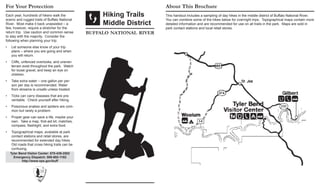
About This Brochure
This handout includes a sampling of day hikes in the middle district of Buffalo National River.
You can combine some of the hikes below for overnight trips. Topographical maps contain more
detailed information and are recommended for use on all trails in the park. Maps are sold in
park contact stations and local retail stores.
Tyler Bend Visitor Center: 870-439-2502
Emergency Dispatch: 888-692-1162
http://www.nps.gov/buff
2. The Buffalo River Trail parallels the national
river, following bluff lines, meandering up
side canyons, and dropping into hollows.
Views of the river accent the way. Other
hikes lead to scenic vistas and historic sites.
Trail difficulty varies, ranging from wheel-
chair accessible terrain to steep climbs over
rocky slopes. Please assist us in protecting
the park by adhering to the following:
Hiking Trails are posted with white•
markers - horse/hiking trails with yellow
markers. Hikers may travel on horse/
hiker trails, but horses are not allowed
on hiking trails.
Pets are not allowed on trails.•
Mountain biking is prohibited on all hik-•
ing and horseback trails.
All-terrain vehicles are prohibited in the•
park.
Stay on the trail – shortcuts create ero-•
sion.
If you must travel cross-country, avoid•
stepping on lichens and fragile plants.
Leave no permanent mark of your travel.
Trash begets trash – please pack out•
your own and as much as you can carry
of others.
Leave things as you find them. Law pro-•
tects all plants, animals, rocks, historic
features, and archeological sites.
Area Trailhead Distance
Hiking
Time
Features
Woolum
1. Woolum to Hwy. 65BRT
Woolum
15.0 mi
24.1 km (o)
9-10 hours
Strenuous, scenic overlooks, links with Ozark Highlands
Trail for longer hiking opportunities, river ford
Tyler Bend
2. River View Visitor Center
1.4 mi
2.3 km (o)
1 hour Moderate; spectacular views, historic site
3. Collier Homestead/River
View**
Collier Homestead
Trail
0.6 mi
1.0 km (o)
1/2-1 hour Easy; historic site, spectacular views
4. Spring Hollow Amphitheater
0.9 mi
1.4 km (o)
1 hour
Moderate; streambed, nice display of spring flowers,
forested
5. Buck Ridge/Rock Wall Amphitheater
2.6 mi
4.2 km (rt)
1-2 hours
Moderate; historic features, nice display of spring flowers,
forested
6. Tyler Bend to Gilbert Visitor Center
5.5 mi
8.8 km (o)
4-5 hours
Moderate; varied terrain, old homesite, scenic overlook,
can get overgrown in summer
Gilbert
7. Gilbert Railroad Trail Gilbert
3.4 mi
5.5 km (rt)
2-3 hours Easy; old railroad pilings, can get overgrown in summer
*(rt) = round trip (o) = one way BRT = Buffalo River Trail **Wheelchair Accessible
Trail Regulations Trail Descriptions