SlideShare ist ein Scribd-Unternehmen logo
1 von 40
PLANNING OF IRRIGATION SYSTEM
TYPES OF CANALS
WATER ALLOWANCE
COMMAND STATEMENT
ENGINEERING CHAK BANDI
CAPACITY STATEMENT
WARABANDI
BASIC REVENUE TERMS
MUHAMMAD FAHIM ASLAM
TYPES OF CANALS
 Depending on Soil Type
o Alluvial Canals (LCC, LBDC Systems)
o Non-Alluvial Canals (GTC, Greater Thal Canal)
 Depending upon Lining
o Lined Canals
o Unlined Canals
 Depending upon Period of flow
o Perennial Canals
o Non-Perennial Canals
JUSTIFICATION CHECKS FOR LINING OF CANAL
 Consideration must be given to seepage rates with
and without lining
 Amount of water saved
 Operation and maintenance costs
 Drainage costs
 Canal size
 Right-of-way
 Allowable velocities
 Structure costs and
 The various types of lining
TYPES OF CANALS
 Classification of canals based on their alignment
o Contour canal (Feeds on one side)
o Watershed canal(Feeds on both sides, aligned on natural
watershed line)
o Side slope canal (Right angles to contour, irrigates both sides,
avoiding the construction of cross-drainage structures)
TYPES OF CANALS
 Classification based on Off taking Point
o Main canal
o Branch canal
o Major Distributary canal
o Minor canal
 Classification based on Source of Water
o Permanent Canals
o Non permanent Canals
TYPES OF CANALS
 Classification based on Financial Output
o Productive Canals (for the revenue generation)
o Protective Canals (for relief works in the area of famine)
 Inundation Canals (supplies from river when stage
is high)
 Classification based on Function of Canal
o Irrigation Canals
o Feeder Canals (For feeding two or more canals,
Rajasthan Feeder Canal, Pat Feeder Canal)
o Power Channel Canals (Ghazi Barotha Canal) 1450MW
LINK CANALS (FROM ONE RIVER TO ANOTHER)
i) Chashma Jhelum Link (C-J Link)
ii) Taunsa Panjnad Link (T-P Link)
iii) Rasul Qadirabad Link (R-Q Link)
iv) Qadirabad Balloki Lin (Q-B Link)
v) Balloki Sulemanki Link II (B-S Link II)
vi) Trimmu Sidhnai Link (T-S Link)
vii) Sidhnai – Milsi – Bahawal Link (S-M-B Link)
TYPES OF CANALS
NAVIGATIONAL/TRANSPORTATION CANALS (E.G,
PANAMA CANAL AND SUEZ CANAL)
• Weirs and Dams to raise river water levels to usable depths;
• Locks to allow ships and barges to ascend/descend.
THE FLIGHT OF 16 CONSECUTIVE LOCKS AT CAEN HILL ON THE KENNET AND
AVON CANAL, WILTSHIRE, ENGLAND
REFERENCES
 Irrigation and Water Power Engineering by dr. B.C
Punmia and Dr. Pande B.B Lal , Page no. 572-576
 Irrigation Engineering and Hydraulic Structures by
Santosh Kumar Garg, Page no.67-73
WATER ALLOWANCE
It is the discharge in cusec required to irrigate 1000
Acres of an area and is expressed in cusec/1000
acres (or in cumec/100 ha)
Factors Affecting Water Allowance
 Climate including rainfall and evaporation
 Soil
 General type of crop
 Nature of crops
 Efficiency of cultivation system
 Delta(∆) :Depth of water required by the crop
 Methods of water application
WATER ALLOWANCE
 Duty of Crop (D): (Number of hectares of land irrigated
by 1m3/sec of water)
The duty of water, or the quantity of water required per acre,’ to
be used for preliminary studies of a canal system, may best
be estimated from records of the use of water under similar
conditions on similar areas and crops.
 Crop Period: Time from sowing to harvesting
 Base Period(B): Time from 1st watering of crop to its
last watering
 Relation b/w Duty and Delta:
∆ = 8.64B/D (meters)
 Intensity of crop
CROP WATER REQUIREMENT
The depth of water needed to meet the water loss through
evapotranspiration (ETcrop) of a disease-free crop,
growing in large fields under nonrestricting soil
conditions including soil water and fertility and achieving
full production potential under the given growing
environment
CALCULATION
1. Evapotranspiration (ETo)
ETo is expressed in mm per day
4 methods to measure Eto
 Blaney-Criddle
 Radiation
 Penman and
 Pan Evaporation method
CROP WATER REQUIREMENT
IRRIGATION EFFICIENCY (E)
To account for losses of water incurred during conveyance and
application to the field, an efficiency factor should be included
when calculating the project irrigation requirements. Project
efficiency is normally subdivided into following stages, each of
which is affected by a different set of conditions:
1. Conveyance efficiency (Ec):
Ratio between water received at inlet to a block of fields and that
released at the project headworks.
2. Field canal efficiency (Eb):
Ratio between water received at the field inlet and that received
at the inlet of the block of fields.
3. Field application efficiency (Ea):
Ratio between water directly available to the crop and that
received at the field inlet.
4. Project efficiency (Ep):
Ratio between water made directly available to the crop and that
released at headworks, or Ep =Ea.Eb.Ec.
REFERENCES
 Irrigation and Water Power Engineering by dr. B.C
Punmia and Dr. Pande B.B Lal , Page no. 572-576
 Irrigation Engineering and Hydraulic Structures by
Santosh Kumar Garg, Page no.67-73
 Manual of Irrigation Practice , Chapter 8,Page no.3-
9
 Canals and Related structures, USBR Manual
 FAO Irrigation and Drainage Paper 24, Crop Water
Requirements, Page 77-79
COMMAND STATEMENT
 Prepared to get the feeding levels of chaks of
channels
 Critical levels are found
 Distance from outlet head to critical level is
measured
 L.Slope of water course (Min 0.2’ to 0.25’ per
thousand)is considered and loss of head related to
is calculated
 Minimum Working head is kept at head
 Field command value is opted
 Water levels are commuted for both critical levels
 Water level required at head is obtained
ENGINEERING CHAKBANDI
 Chak: Area irrigated by outlet
 Factors affecting size of chak
o Discharge
o Natural Slope
o Political boundaries of villages
 Drawn with the help of Contour maps
 Local ridges and depressions must be marked
 Settlements and Un commanded area must be marked
 GCA is calculated
 CCA is calculated
 Separate chak for Un commanded area must be formed
 Crossing of Natural and man made barriers (hills, sand dunes,
roads, railways etc) must be avoided
 Revenue Chak Bandi is planned afterwards
CAPACITY STATEMENT
It is experienced that after construction of the canal, the
various unanticipated water demands arises due to various
reasons which affects the carrying capacity of canal assumed
at the time of design of canal.
1. The drinking and industrial water requirement demands
2. The letting out of water in rivers, nala during scarcity period
3. The demands for lift irrigation schemes on uncommand side
of the Canals
4. The increased water demand due to the rich cropping
pattern (Water intensive) adopted by farmers
5. The demand for letting the water in storage tanks in
command area and recharging of the command area during
monsoon period.
CAPACITY STATEMENT
 It should be sufficient to deliver the irrigation water
to planned command area and designed cropping
pattern of project in expected rotation period
WARABANDI
• Warabandi is a rotational method for equitable distribution of
the available water in an irrigation system by turns fixed
according to predetermined schedule specifying the day, time
and duration of supply to each irrigator in proportion to size of
his land holding in the outlet command.(Singh 1981, Malhotra
1982)
• Prepared by the Irrigation department
OBJECTIVES OF WARABANDI
As an integrated water management system, warabandi is
expected to achieve two main objectives,
 High efficiency
 Equity in water use
WARABANDI
 KACHA WARABANDI
The warabandi which has been decided by the farmers
solely on their mutual agreement, without
formal involvement of any government agency is known
as kachcha ( ordinary or unregulated) warabandi.
 PUCCA WARABANDI
The warabandi decided after field investigation and public
inquiry by the irrigation department when disputes
occurred and issued in officially recognized warabandi
schedules, is called pucca warabandi.
TYPES OF WARABANDI
BASIC REVENUE TERMS
PATWARI
 Subordinate to SDO
 Incharge of Halqa(Group of villages)
 Prepares Initial Record on which Canal water
revenue is assessed and collected
 Prepares Record of Measurement(Kasra
Gardawari)
 Reports Zilladar for Canal water theft
 Prepares Village note book(small scale sketches of
water courses, chaks)
BASIC REVENUE TERMS
GIRDAWAR/QANOONGO
Supervisor of Patwaris
GIRDAWARI
Harvest inspection
LAMBARDAR
Village head
HALQA
It consists of definite group of villages, 3000 to 5000 acers in Patwar Circle
CROPS YEAR
Booking and Assessment of two major crops
KHASRAH
Field measurement book
KHASRAH JINSWAR
Crop estimation registers
SHUDKAR
Recording of area under irrigation by the Patwari before cultivation and final
measurement of crops
Lal KITAB
Note Book in which Patwari prepares small scale sketches of water courses chaks of
his halqa
BASIC REVENUE TERMS
JAMABANDI
Register of holdings of owners and tenants showing land held by
each person, land revenue and cesses
KARAM
Unit of length (5 pace/kadam)(5’6”)
KHADIR
Low laying land near river
BURJI
Survey Pillar (1 RD)
BARANI
Dependent on rainfall
LATHAA GIRDAWARI
A cloth copy of Patwari map or
A map of village/mouza showing khasra numbers and
size
BASIC REVENUE TERMS
Masavee
A map of village on hard paper, placed under the
supervisison of Girdawar/ Mapping sheet
Lathaa
Masavee
BASIC REVENUE TERMS
Sihadda
Masonary pillar erected where boundaries of three
villages meet
Abiyana
A tax money given to lambardar by the farmers for the
irrigation supplies
Khata
Holding of a tenant
Munshee
Assistant of patwari/ girdawar
Kachahri
District court house
Khewat
A list of owners holding
BASIC REVENUE TERMS
Banjar Kham
Land, which has remained unsown for 4 to 11 successive
harvests.
Farad
A copy of land record.
Ghair Mumkin
Is uncultivated land such as bed of a nullah, road graveyard etc.
Malia
Land revenue
Shajra Nasab
The genealogical tree of the landowners in a village, prepared
at the time of settlement. Updated in Charsala after every four
years, it is a mandatory part of the Record-of-Rights.
Tatima Shajra
A revised map of any field in consequences of partition, transfer,
inheritance etc.
BASIC STRUCTURE OF LAND ADMINISTRATION
Country
Province
Division
District
Tehsil/Taluka
Qanoongo Halqa (QH)
Patwar Circle (PC)
Mauza/Village
TYPES OF LAND
 State Owned Land
Land owned by Govt. (Sarkaari zameen). Fed. Or Prov.
It means that its ownership or legal entitlement vests in the government.
State land may be classified as follows:
a) State land assigned to individuals for various uses including cultivation,
storage etc. on a temporary basis. This type of land can normally be
resumed by the state;
b) State land granted to individuals under various schemes like cattle
breeding, horse studs etc. In this category, the ownership belongs to
the state and it is possessed by the citizens on a temporary basis
against a nominal annual rent to be paid by user to the state;
c) Governments used to grant lands to the influential citizens as Jaagir
(gift, largesse;
d) State Land is cultivated directly under the State.
e) State lands that are under some government scheme or are under
afforestation;
f) State lands that are barren and are not under cultivation or cannot be
made cultivatable due to its inhospitable terrain or unsuitable soil.
TYPES OF LAND
 Privately Owned Land
a) Farmland usually falls under private ownership.
b) Farmland may be self-cultivated (khud kaasht) or
cultivated through tenants who pay agreed rent to the
owner either in cash or in kind;
c) Some owners of land get the land cultivated through
servants or seasonal labour. It remains in the category
of self-cultivated;
d) Private owners have full rights to sell, gift, exchange or
dispose of their private land in any manner they wish
subject to some legal limitations.
e) The private owned land is subject to automatic
inheritance under the Muslim personal law and the
property rights devolve after the death of a legal owner
on his/her legal heirs
TYPES OF LAND
 Shamilat or Shamilat Deh
a) Village common land.
b) Shamilat land is a grant given by the State, out of State land, to the
owners of the village to be used for their common purposes and is
usually granted at the time of settlement; common places include
grazing grounds, firewood collection, graveyards, community
buildings, mosques, schools, dispensaries, play grounds, village
ponds, village roads, passages for the movement of cattle etc;
c) All persons recorded as owners of land in a village are also joint
owners of Shamilat of the village, their shares being proportionate to
the size of their holding vis-à-vis total farm land in the village;
d) When they sell their land, the share of shaamlaat also goes to the
new buyer accordingly.
TYPES OF PROERTIES
 'Immoveable property' includes land, buildings, benefits to
arise out of land and things attached to the earth, or
permanently fastened to anything attached to the earth,
hereditary allowances, rights to ways, lights, ferries and
fisheries. But does not include: i. Standing timber, growing
crops or grass; ii. Fruit upon and juice in trees whether in
existence or to grow in future; and iii. Machinery embedded in
or attached to the earth, when dealt with apart from the land.
 Moveable property
Property of every description except immoveable property
LAND ACQUISITION BY STATE
The Constitution of Pakistan, 1973 recognizes the fundamental right to
acquire, hold and dispose off private property in any part of Pakistan
Article 23 and 24 deal with it
The state can compulsorily acquire or take into possession the private
property under article 24 in the following cases:
i. For preventing danger to life, property or public health;
ii. If any property which has been acquired by, or comes into the
possession of, any person by any unfair means, or in any manner,
contrary to law;
iii. Enemy property or evacuee property under any law;
iv. For providing education and medical aid to all or any specified
class of citizens;
v. For providing housing and public facilities and services such as
roads, water supply, sewerage, gas and electric power
vi. vi. For providing maintenance to those who, on account of
unemployment, sickness, infirmity or old age, are unable to
maintain themselves.
LAND ACQUISITION BY STATE
 The lands can be acquired under the following two laws:
i. Land Acquisition Act, 1894; and
ii. Capital Development Authority Ordinance, 1960. b) First and
foremost and most commonly invoked law is the 1894 Act that
permits acquisition for public purpose, (for railways, schools,
hospitals etc.).
Land acquisition Act, 1894 designates the Revenue Authorities
under respective Boards of Revenue to process the
acquisitions. The acquisition may be voluntary or compulsory.
Capital Regulation of 1959 was related to lands demarcated for
establishment of Islamabad as the permanent Capital. Later,
the Regulation was incorporated in the Capital Development
Authority Ordinance, 1960.
LAND ACQUISITION BY STATE
 The process of land acquisition is initiated with a decision by a
Federal, Provincial or Local Government Department or a
public company (called acquiring agency) to execute a 'public
purpose' project and such acquiring agency first secures the
funds for the land acquisition.
 The acquiring agency conveys the desire for acquisition to
the local District Collector/Deputy Commissioner and deposits
the estimated compensation in government treasury in the
non-lapsable account of the Collector.
 The Collector computes this estimated compensation and in
his/her final order, it can be changed. When the Collector
decides that the land is needed for any public purpose or for a
Company, a notification to that effect is published in the official
Gazette, and the Collector gives a public notice of the
notification.
 After this notification, it is lawful for any authorized officer:
i. To enter upon and survey and take levels of the land;
ii. To dig or bore into the subsoil;
iii. To do all other acts necessary to ascertain whether the land
is adapted for such purpose;
LAND ACQUISITION BY STATE
iv. To set out the boundaries of the land proposed to be taken and the
intended line of the work (if any) proposed to be made thereon; A
Guide on Land and Property Rights in Pakistan 56 14.3 Purpose of
the Land Acquisition
The Collector then undertakes detailed demarcation of the land
proposed for acquisition to ensure amongst others that no parcel is
already under any public use, a graveyard, an educational facility or
a watercourse or already notified for some other departmental
requirement
The Collector shall then give public notice that the Government intends
to take possession of the particular land, and that claims to
compensation for and the objections about the measurement of the
land may be made to him/her.
In case immediate possession is deemed necessary by the acquiring
department and the Collector, an additional Gazette notification by
the Divisional Commissioner is required that obligates15% extra
payments to the owner.
LAND ACQUISITION BY STATE
The Collector enquires into the objections (if any) which any person
interested may have made about the measurements and the value of
the land and then he/she makes an award of:
(i) the actual area of the land;
(ii) (ii) the compensation which in his/her opinion should be allowed for
the land; and
(iii) the apportionment of the compensation among all the relevant
persons. This is called 'Award' and it is final and conclusive.

Weitere ähnliche Inhalte

Was ist angesagt?

LINING OF CHANNELS
LINING OF CHANNELSLINING OF CHANNELS
LINING OF CHANNELS
ANURAG YADAV
 

Was ist angesagt? (20)

Design of Lined Canal and Canal Lining
Design of Lined Canal and Canal LiningDesign of Lined Canal and Canal Lining
Design of Lined Canal and Canal Lining
 
Duty delta etc
Duty delta etcDuty delta etc
Duty delta etc
 
design of weirs
design of weirsdesign of weirs
design of weirs
 
Stream flow measurement
Stream flow  measurementStream flow  measurement
Stream flow measurement
 
Regulating structure for canal flow
Regulating structure for canal flowRegulating structure for canal flow
Regulating structure for canal flow
 
Duty, Delta and Base Period and their relationship
Duty, Delta and Base Period and their relationshipDuty, Delta and Base Period and their relationship
Duty, Delta and Base Period and their relationship
 
Well
WellWell
Well
 
Groundwater improvement techniques
Groundwater improvement techniques Groundwater improvement techniques
Groundwater improvement techniques
 
water distribution system & warabandi by Denish Jangid unit 2 Water Resources...
water distribution system & warabandi by Denish Jangid unit 2 Water Resources...water distribution system & warabandi by Denish Jangid unit 2 Water Resources...
water distribution system & warabandi by Denish Jangid unit 2 Water Resources...
 
Kennedy's and laccy's theory
Kennedy's and laccy's theoryKennedy's and laccy's theory
Kennedy's and laccy's theory
 
Cross drainage work
Cross drainage work Cross drainage work
Cross drainage work
 
Irrigation
Irrigation Irrigation
Irrigation
 
Canal Regulation & Cross Drainage Works
Canal Regulation & Cross Drainage WorksCanal Regulation & Cross Drainage Works
Canal Regulation & Cross Drainage Works
 
Stream flow measurement
Stream flow measurementStream flow measurement
Stream flow measurement
 
Unit 1 Crop Water Requirement
Unit 1 Crop Water RequirementUnit 1 Crop Water Requirement
Unit 1 Crop Water Requirement
 
LINING OF CHANNELS
LINING OF CHANNELSLINING OF CHANNELS
LINING OF CHANNELS
 
Spillways
SpillwaysSpillways
Spillways
 
Canal outlets and modules
Canal outlets and modulesCanal outlets and modules
Canal outlets and modules
 
Design of hydraulic structures ce 413
Design of hydraulic structures ce 413Design of hydraulic structures ce 413
Design of hydraulic structures ce 413
 
Reservoir Planning
Reservoir PlanningReservoir Planning
Reservoir Planning
 

Ähnlich wie Planning of irrigation system

Ähnlich wie Planning of irrigation system (20)

Water resources in Bangalore_Ramasesha_2013
Water resources in Bangalore_Ramasesha_2013Water resources in Bangalore_Ramasesha_2013
Water resources in Bangalore_Ramasesha_2013
 
DSD-SEA 2018 RIBASIM Applied For Subak Irrigation Schemes In Yeh Ho River Bas...
DSD-SEA 2018 RIBASIM Applied For Subak Irrigation Schemes In Yeh Ho River Bas...DSD-SEA 2018 RIBASIM Applied For Subak Irrigation Schemes In Yeh Ho River Bas...
DSD-SEA 2018 RIBASIM Applied For Subak Irrigation Schemes In Yeh Ho River Bas...
 
H0372040043
H0372040043H0372040043
H0372040043
 
Site Selection for Rain Water Harvesting Structures
Site Selection for Rain Water Harvesting StructuresSite Selection for Rain Water Harvesting Structures
Site Selection for Rain Water Harvesting Structures
 
Introduction of Irrigation & it's Methods with Crop classification
Introduction of Irrigation & it's Methods with Crop classificationIntroduction of Irrigation & it's Methods with Crop classification
Introduction of Irrigation & it's Methods with Crop classification
 
Tubewell guideline(1)
Tubewell  guideline(1)Tubewell  guideline(1)
Tubewell guideline(1)
 
IRJET- Groundwater Replenishment in Ambernath Region
IRJET- Groundwater Replenishment in Ambernath RegionIRJET- Groundwater Replenishment in Ambernath Region
IRJET- Groundwater Replenishment in Ambernath Region
 
Water harvesting structures
Water harvesting structures Water harvesting structures
Water harvesting structures
 
systems of irrigations
systems of irrigationssystems of irrigations
systems of irrigations
 
Introduction to Irrigation System of Pakistan
Introduction to Irrigation System of PakistanIntroduction to Irrigation System of Pakistan
Introduction to Irrigation System of Pakistan
 
Modeling the water food-energy nexus in the arab world: River basin simulatio...
Modeling the water food-energy nexus in the arab world: River basin simulatio...Modeling the water food-energy nexus in the arab world: River basin simulatio...
Modeling the water food-energy nexus in the arab world: River basin simulatio...
 
Wsse
WsseWsse
Wsse
 
4.pdf
4.pdf4.pdf
4.pdf
 
presentation of industrial training irrigation (2).pptx
presentation of industrial training irrigation (2).pptxpresentation of industrial training irrigation (2).pptx
presentation of industrial training irrigation (2).pptx
 
Case Studies of Water Supply Infrastructures
Case Studies of Water Supply InfrastructuresCase Studies of Water Supply Infrastructures
Case Studies of Water Supply Infrastructures
 
Shah,cr, watershed management presentation,mu,17 june 2017
Shah,cr, watershed management presentation,mu,17 june 2017Shah,cr, watershed management presentation,mu,17 june 2017
Shah,cr, watershed management presentation,mu,17 june 2017
 
Irrigation engineering m1
Irrigation engineering m1Irrigation engineering m1
Irrigation engineering m1
 
Engineer hamza Rainwater harvesting
Engineer hamza Rainwater harvestingEngineer hamza Rainwater harvesting
Engineer hamza Rainwater harvesting
 
Jaipur_water supply service.pdf
Jaipur_water supply service.pdfJaipur_water supply service.pdf
Jaipur_water supply service.pdf
 
Irrigation introduction
Irrigation introduction Irrigation introduction
Irrigation introduction
 

Kürzlich hochgeladen

Call Girls in South Ex (delhi) call me [🔝9953056974🔝] escort service 24X7
Call Girls in South Ex (delhi) call me [🔝9953056974🔝] escort service 24X7Call Girls in South Ex (delhi) call me [🔝9953056974🔝] escort service 24X7
Call Girls in South Ex (delhi) call me [🔝9953056974🔝] escort service 24X7
9953056974 Low Rate Call Girls In Saket, Delhi NCR
 
XXXXXXXXXXXXXXXXXXXXXXXXXXXXXXXXXXXXXXXXXXXXXXXXXXXX
XXXXXXXXXXXXXXXXXXXXXXXXXXXXXXXXXXXXXXXXXXXXXXXXXXXXXXXXXXXXXXXXXXXXXXXXXXXXXXXXXXXXXXXXXXXXXXXXXXXXXXXX
XXXXXXXXXXXXXXXXXXXXXXXXXXXXXXXXXXXXXXXXXXXXXXXXXXXX
ssuser89054b
 
+97470301568>> buy weed in qatar,buy thc oil qatar,buy weed and vape oil in d...
+97470301568>> buy weed in qatar,buy thc oil qatar,buy weed and vape oil in d...+97470301568>> buy weed in qatar,buy thc oil qatar,buy weed and vape oil in d...
+97470301568>> buy weed in qatar,buy thc oil qatar,buy weed and vape oil in d...
Health
 
Cara Menggugurkan Sperma Yang Masuk Rahim Biyar Tidak Hamil
Cara Menggugurkan Sperma Yang Masuk Rahim Biyar Tidak HamilCara Menggugurkan Sperma Yang Masuk Rahim Biyar Tidak Hamil
Cara Menggugurkan Sperma Yang Masuk Rahim Biyar Tidak Hamil
Cara Menggugurkan Kandungan 087776558899
 
DeepFakes presentation : brief idea of DeepFakes
DeepFakes presentation : brief idea of DeepFakesDeepFakes presentation : brief idea of DeepFakes
DeepFakes presentation : brief idea of DeepFakes
MayuraD1
 
Standard vs Custom Battery Packs - Decoding the Power Play
Standard vs Custom Battery Packs - Decoding the Power PlayStandard vs Custom Battery Packs - Decoding the Power Play
Standard vs Custom Battery Packs - Decoding the Power Play
Epec Engineered Technologies
 

Kürzlich hochgeladen (20)

Online food ordering system project report.pdf
Online food ordering system project report.pdfOnline food ordering system project report.pdf
Online food ordering system project report.pdf
 
Air Compressor reciprocating single stage
Air Compressor reciprocating single stageAir Compressor reciprocating single stage
Air Compressor reciprocating single stage
 
Unleashing the Power of the SORA AI lastest leap
Unleashing the Power of the SORA AI lastest leapUnleashing the Power of the SORA AI lastest leap
Unleashing the Power of the SORA AI lastest leap
 
Introduction to Serverless with AWS Lambda
Introduction to Serverless with AWS LambdaIntroduction to Serverless with AWS Lambda
Introduction to Serverless with AWS Lambda
 
Bhubaneswar🌹Call Girls Bhubaneswar ❤Komal 9777949614 💟 Full Trusted CALL GIRL...
Bhubaneswar🌹Call Girls Bhubaneswar ❤Komal 9777949614 💟 Full Trusted CALL GIRL...Bhubaneswar🌹Call Girls Bhubaneswar ❤Komal 9777949614 💟 Full Trusted CALL GIRL...
Bhubaneswar🌹Call Girls Bhubaneswar ❤Komal 9777949614 💟 Full Trusted CALL GIRL...
 
Navigating Complexity: The Role of Trusted Partners and VIAS3D in Dassault Sy...
Navigating Complexity: The Role of Trusted Partners and VIAS3D in Dassault Sy...Navigating Complexity: The Role of Trusted Partners and VIAS3D in Dassault Sy...
Navigating Complexity: The Role of Trusted Partners and VIAS3D in Dassault Sy...
 
Work-Permit-Receiver-in-Saudi-Aramco.pptx
Work-Permit-Receiver-in-Saudi-Aramco.pptxWork-Permit-Receiver-in-Saudi-Aramco.pptx
Work-Permit-Receiver-in-Saudi-Aramco.pptx
 
Design For Accessibility: Getting it right from the start
Design For Accessibility: Getting it right from the startDesign For Accessibility: Getting it right from the start
Design For Accessibility: Getting it right from the start
 
Call Girls in South Ex (delhi) call me [🔝9953056974🔝] escort service 24X7
Call Girls in South Ex (delhi) call me [🔝9953056974🔝] escort service 24X7Call Girls in South Ex (delhi) call me [🔝9953056974🔝] escort service 24X7
Call Girls in South Ex (delhi) call me [🔝9953056974🔝] escort service 24X7
 
Computer Networks Basics of Network Devices
Computer Networks  Basics of Network DevicesComputer Networks  Basics of Network Devices
Computer Networks Basics of Network Devices
 
XXXXXXXXXXXXXXXXXXXXXXXXXXXXXXXXXXXXXXXXXXXXXXXXXXXX
XXXXXXXXXXXXXXXXXXXXXXXXXXXXXXXXXXXXXXXXXXXXXXXXXXXXXXXXXXXXXXXXXXXXXXXXXXXXXXXXXXXXXXXXXXXXXXXXXXXXXXXX
XXXXXXXXXXXXXXXXXXXXXXXXXXXXXXXXXXXXXXXXXXXXXXXXXXXX
 
+97470301568>> buy weed in qatar,buy thc oil qatar,buy weed and vape oil in d...
+97470301568>> buy weed in qatar,buy thc oil qatar,buy weed and vape oil in d...+97470301568>> buy weed in qatar,buy thc oil qatar,buy weed and vape oil in d...
+97470301568>> buy weed in qatar,buy thc oil qatar,buy weed and vape oil in d...
 
Cara Menggugurkan Sperma Yang Masuk Rahim Biyar Tidak Hamil
Cara Menggugurkan Sperma Yang Masuk Rahim Biyar Tidak HamilCara Menggugurkan Sperma Yang Masuk Rahim Biyar Tidak Hamil
Cara Menggugurkan Sperma Yang Masuk Rahim Biyar Tidak Hamil
 
DeepFakes presentation : brief idea of DeepFakes
DeepFakes presentation : brief idea of DeepFakesDeepFakes presentation : brief idea of DeepFakes
DeepFakes presentation : brief idea of DeepFakes
 
Learn the concepts of Thermodynamics on Magic Marks
Learn the concepts of Thermodynamics on Magic MarksLearn the concepts of Thermodynamics on Magic Marks
Learn the concepts of Thermodynamics on Magic Marks
 
Hostel management system project report..pdf
Hostel management system project report..pdfHostel management system project report..pdf
Hostel management system project report..pdf
 
S1S2 B.Arch MGU - HOA1&2 Module 3 -Temple Architecture of Kerala.pptx
S1S2 B.Arch MGU - HOA1&2 Module 3 -Temple Architecture of Kerala.pptxS1S2 B.Arch MGU - HOA1&2 Module 3 -Temple Architecture of Kerala.pptx
S1S2 B.Arch MGU - HOA1&2 Module 3 -Temple Architecture of Kerala.pptx
 
Standard vs Custom Battery Packs - Decoding the Power Play
Standard vs Custom Battery Packs - Decoding the Power PlayStandard vs Custom Battery Packs - Decoding the Power Play
Standard vs Custom Battery Packs - Decoding the Power Play
 
Minimum and Maximum Modes of microprocessor 8086
Minimum and Maximum Modes of microprocessor 8086Minimum and Maximum Modes of microprocessor 8086
Minimum and Maximum Modes of microprocessor 8086
 
Rums floating Omkareshwar FSPV IM_16112021.pdf
Rums floating Omkareshwar FSPV IM_16112021.pdfRums floating Omkareshwar FSPV IM_16112021.pdf
Rums floating Omkareshwar FSPV IM_16112021.pdf
 

Planning of irrigation system

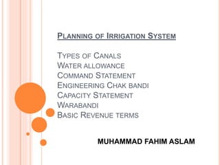
  • 1. PLANNING OF IRRIGATION SYSTEM TYPES OF CANALS WATER ALLOWANCE COMMAND STATEMENT ENGINEERING CHAK BANDI CAPACITY STATEMENT WARABANDI BASIC REVENUE TERMS MUHAMMAD FAHIM ASLAM
  • 2. TYPES OF CANALS  Depending on Soil Type o Alluvial Canals (LCC, LBDC Systems) o Non-Alluvial Canals (GTC, Greater Thal Canal)  Depending upon Lining o Lined Canals o Unlined Canals  Depending upon Period of flow o Perennial Canals o Non-Perennial Canals
  • 3. JUSTIFICATION CHECKS FOR LINING OF CANAL  Consideration must be given to seepage rates with and without lining  Amount of water saved  Operation and maintenance costs  Drainage costs  Canal size  Right-of-way  Allowable velocities  Structure costs and  The various types of lining
  • 4. TYPES OF CANALS  Classification of canals based on their alignment o Contour canal (Feeds on one side) o Watershed canal(Feeds on both sides, aligned on natural watershed line) o Side slope canal (Right angles to contour, irrigates both sides, avoiding the construction of cross-drainage structures)
  • 5. TYPES OF CANALS  Classification based on Off taking Point o Main canal o Branch canal o Major Distributary canal o Minor canal  Classification based on Source of Water o Permanent Canals o Non permanent Canals
  • 6. TYPES OF CANALS  Classification based on Financial Output o Productive Canals (for the revenue generation) o Protective Canals (for relief works in the area of famine)  Inundation Canals (supplies from river when stage is high)  Classification based on Function of Canal o Irrigation Canals o Feeder Canals (For feeding two or more canals, Rajasthan Feeder Canal, Pat Feeder Canal) o Power Channel Canals (Ghazi Barotha Canal) 1450MW
  • 7. LINK CANALS (FROM ONE RIVER TO ANOTHER) i) Chashma Jhelum Link (C-J Link) ii) Taunsa Panjnad Link (T-P Link) iii) Rasul Qadirabad Link (R-Q Link) iv) Qadirabad Balloki Lin (Q-B Link) v) Balloki Sulemanki Link II (B-S Link II) vi) Trimmu Sidhnai Link (T-S Link) vii) Sidhnai – Milsi – Bahawal Link (S-M-B Link) TYPES OF CANALS
  • 8. NAVIGATIONAL/TRANSPORTATION CANALS (E.G, PANAMA CANAL AND SUEZ CANAL) • Weirs and Dams to raise river water levels to usable depths; • Locks to allow ships and barges to ascend/descend.
  • 9. THE FLIGHT OF 16 CONSECUTIVE LOCKS AT CAEN HILL ON THE KENNET AND AVON CANAL, WILTSHIRE, ENGLAND
  • 10. REFERENCES  Irrigation and Water Power Engineering by dr. B.C Punmia and Dr. Pande B.B Lal , Page no. 572-576  Irrigation Engineering and Hydraulic Structures by Santosh Kumar Garg, Page no.67-73
  • 11. WATER ALLOWANCE It is the discharge in cusec required to irrigate 1000 Acres of an area and is expressed in cusec/1000 acres (or in cumec/100 ha) Factors Affecting Water Allowance  Climate including rainfall and evaporation  Soil  General type of crop  Nature of crops  Efficiency of cultivation system  Delta(∆) :Depth of water required by the crop  Methods of water application
  • 12. WATER ALLOWANCE  Duty of Crop (D): (Number of hectares of land irrigated by 1m3/sec of water) The duty of water, or the quantity of water required per acre,’ to be used for preliminary studies of a canal system, may best be estimated from records of the use of water under similar conditions on similar areas and crops.  Crop Period: Time from sowing to harvesting  Base Period(B): Time from 1st watering of crop to its last watering  Relation b/w Duty and Delta: ∆ = 8.64B/D (meters)  Intensity of crop
  • 13. CROP WATER REQUIREMENT The depth of water needed to meet the water loss through evapotranspiration (ETcrop) of a disease-free crop, growing in large fields under nonrestricting soil conditions including soil water and fertility and achieving full production potential under the given growing environment CALCULATION 1. Evapotranspiration (ETo) ETo is expressed in mm per day 4 methods to measure Eto  Blaney-Criddle  Radiation  Penman and  Pan Evaporation method
  • 15. IRRIGATION EFFICIENCY (E) To account for losses of water incurred during conveyance and application to the field, an efficiency factor should be included when calculating the project irrigation requirements. Project efficiency is normally subdivided into following stages, each of which is affected by a different set of conditions: 1. Conveyance efficiency (Ec): Ratio between water received at inlet to a block of fields and that released at the project headworks. 2. Field canal efficiency (Eb): Ratio between water received at the field inlet and that received at the inlet of the block of fields. 3. Field application efficiency (Ea): Ratio between water directly available to the crop and that received at the field inlet. 4. Project efficiency (Ep): Ratio between water made directly available to the crop and that released at headworks, or Ep =Ea.Eb.Ec.
  • 16.
  • 17. REFERENCES  Irrigation and Water Power Engineering by dr. B.C Punmia and Dr. Pande B.B Lal , Page no. 572-576  Irrigation Engineering and Hydraulic Structures by Santosh Kumar Garg, Page no.67-73  Manual of Irrigation Practice , Chapter 8,Page no.3- 9  Canals and Related structures, USBR Manual  FAO Irrigation and Drainage Paper 24, Crop Water Requirements, Page 77-79
  • 18. COMMAND STATEMENT  Prepared to get the feeding levels of chaks of channels  Critical levels are found  Distance from outlet head to critical level is measured  L.Slope of water course (Min 0.2’ to 0.25’ per thousand)is considered and loss of head related to is calculated  Minimum Working head is kept at head  Field command value is opted  Water levels are commuted for both critical levels  Water level required at head is obtained
  • 19. ENGINEERING CHAKBANDI  Chak: Area irrigated by outlet  Factors affecting size of chak o Discharge o Natural Slope o Political boundaries of villages  Drawn with the help of Contour maps  Local ridges and depressions must be marked  Settlements and Un commanded area must be marked  GCA is calculated  CCA is calculated  Separate chak for Un commanded area must be formed  Crossing of Natural and man made barriers (hills, sand dunes, roads, railways etc) must be avoided  Revenue Chak Bandi is planned afterwards
  • 20.
  • 21. CAPACITY STATEMENT It is experienced that after construction of the canal, the various unanticipated water demands arises due to various reasons which affects the carrying capacity of canal assumed at the time of design of canal. 1. The drinking and industrial water requirement demands 2. The letting out of water in rivers, nala during scarcity period 3. The demands for lift irrigation schemes on uncommand side of the Canals 4. The increased water demand due to the rich cropping pattern (Water intensive) adopted by farmers 5. The demand for letting the water in storage tanks in command area and recharging of the command area during monsoon period.
  • 22. CAPACITY STATEMENT  It should be sufficient to deliver the irrigation water to planned command area and designed cropping pattern of project in expected rotation period
  • 23. WARABANDI • Warabandi is a rotational method for equitable distribution of the available water in an irrigation system by turns fixed according to predetermined schedule specifying the day, time and duration of supply to each irrigator in proportion to size of his land holding in the outlet command.(Singh 1981, Malhotra 1982) • Prepared by the Irrigation department OBJECTIVES OF WARABANDI As an integrated water management system, warabandi is expected to achieve two main objectives,  High efficiency  Equity in water use
  • 24. WARABANDI  KACHA WARABANDI The warabandi which has been decided by the farmers solely on their mutual agreement, without formal involvement of any government agency is known as kachcha ( ordinary or unregulated) warabandi.  PUCCA WARABANDI The warabandi decided after field investigation and public inquiry by the irrigation department when disputes occurred and issued in officially recognized warabandi schedules, is called pucca warabandi. TYPES OF WARABANDI
  • 25. BASIC REVENUE TERMS PATWARI  Subordinate to SDO  Incharge of Halqa(Group of villages)  Prepares Initial Record on which Canal water revenue is assessed and collected  Prepares Record of Measurement(Kasra Gardawari)  Reports Zilladar for Canal water theft  Prepares Village note book(small scale sketches of water courses, chaks)
  • 26. BASIC REVENUE TERMS GIRDAWAR/QANOONGO Supervisor of Patwaris GIRDAWARI Harvest inspection LAMBARDAR Village head HALQA It consists of definite group of villages, 3000 to 5000 acers in Patwar Circle CROPS YEAR Booking and Assessment of two major crops KHASRAH Field measurement book KHASRAH JINSWAR Crop estimation registers SHUDKAR Recording of area under irrigation by the Patwari before cultivation and final measurement of crops Lal KITAB Note Book in which Patwari prepares small scale sketches of water courses chaks of his halqa
  • 27. BASIC REVENUE TERMS JAMABANDI Register of holdings of owners and tenants showing land held by each person, land revenue and cesses KARAM Unit of length (5 pace/kadam)(5’6”) KHADIR Low laying land near river BURJI Survey Pillar (1 RD) BARANI Dependent on rainfall LATHAA GIRDAWARI A cloth copy of Patwari map or A map of village/mouza showing khasra numbers and size
  • 28. BASIC REVENUE TERMS Masavee A map of village on hard paper, placed under the supervisison of Girdawar/ Mapping sheet Lathaa Masavee
  • 29. BASIC REVENUE TERMS Sihadda Masonary pillar erected where boundaries of three villages meet Abiyana A tax money given to lambardar by the farmers for the irrigation supplies Khata Holding of a tenant Munshee Assistant of patwari/ girdawar Kachahri District court house Khewat A list of owners holding
  • 30. BASIC REVENUE TERMS Banjar Kham Land, which has remained unsown for 4 to 11 successive harvests. Farad A copy of land record. Ghair Mumkin Is uncultivated land such as bed of a nullah, road graveyard etc. Malia Land revenue Shajra Nasab The genealogical tree of the landowners in a village, prepared at the time of settlement. Updated in Charsala after every four years, it is a mandatory part of the Record-of-Rights. Tatima Shajra A revised map of any field in consequences of partition, transfer, inheritance etc.
  • 31. BASIC STRUCTURE OF LAND ADMINISTRATION Country Province Division District Tehsil/Taluka Qanoongo Halqa (QH) Patwar Circle (PC) Mauza/Village
  • 32. TYPES OF LAND  State Owned Land Land owned by Govt. (Sarkaari zameen). Fed. Or Prov. It means that its ownership or legal entitlement vests in the government. State land may be classified as follows: a) State land assigned to individuals for various uses including cultivation, storage etc. on a temporary basis. This type of land can normally be resumed by the state; b) State land granted to individuals under various schemes like cattle breeding, horse studs etc. In this category, the ownership belongs to the state and it is possessed by the citizens on a temporary basis against a nominal annual rent to be paid by user to the state; c) Governments used to grant lands to the influential citizens as Jaagir (gift, largesse; d) State Land is cultivated directly under the State. e) State lands that are under some government scheme or are under afforestation; f) State lands that are barren and are not under cultivation or cannot be made cultivatable due to its inhospitable terrain or unsuitable soil.
  • 33. TYPES OF LAND  Privately Owned Land a) Farmland usually falls under private ownership. b) Farmland may be self-cultivated (khud kaasht) or cultivated through tenants who pay agreed rent to the owner either in cash or in kind; c) Some owners of land get the land cultivated through servants or seasonal labour. It remains in the category of self-cultivated; d) Private owners have full rights to sell, gift, exchange or dispose of their private land in any manner they wish subject to some legal limitations. e) The private owned land is subject to automatic inheritance under the Muslim personal law and the property rights devolve after the death of a legal owner on his/her legal heirs
  • 34. TYPES OF LAND  Shamilat or Shamilat Deh a) Village common land. b) Shamilat land is a grant given by the State, out of State land, to the owners of the village to be used for their common purposes and is usually granted at the time of settlement; common places include grazing grounds, firewood collection, graveyards, community buildings, mosques, schools, dispensaries, play grounds, village ponds, village roads, passages for the movement of cattle etc; c) All persons recorded as owners of land in a village are also joint owners of Shamilat of the village, their shares being proportionate to the size of their holding vis-à-vis total farm land in the village; d) When they sell their land, the share of shaamlaat also goes to the new buyer accordingly.
  • 35. TYPES OF PROERTIES  'Immoveable property' includes land, buildings, benefits to arise out of land and things attached to the earth, or permanently fastened to anything attached to the earth, hereditary allowances, rights to ways, lights, ferries and fisheries. But does not include: i. Standing timber, growing crops or grass; ii. Fruit upon and juice in trees whether in existence or to grow in future; and iii. Machinery embedded in or attached to the earth, when dealt with apart from the land.  Moveable property Property of every description except immoveable property
  • 36. LAND ACQUISITION BY STATE The Constitution of Pakistan, 1973 recognizes the fundamental right to acquire, hold and dispose off private property in any part of Pakistan Article 23 and 24 deal with it The state can compulsorily acquire or take into possession the private property under article 24 in the following cases: i. For preventing danger to life, property or public health; ii. If any property which has been acquired by, or comes into the possession of, any person by any unfair means, or in any manner, contrary to law; iii. Enemy property or evacuee property under any law; iv. For providing education and medical aid to all or any specified class of citizens; v. For providing housing and public facilities and services such as roads, water supply, sewerage, gas and electric power vi. vi. For providing maintenance to those who, on account of unemployment, sickness, infirmity or old age, are unable to maintain themselves.
  • 37. LAND ACQUISITION BY STATE  The lands can be acquired under the following two laws: i. Land Acquisition Act, 1894; and ii. Capital Development Authority Ordinance, 1960. b) First and foremost and most commonly invoked law is the 1894 Act that permits acquisition for public purpose, (for railways, schools, hospitals etc.). Land acquisition Act, 1894 designates the Revenue Authorities under respective Boards of Revenue to process the acquisitions. The acquisition may be voluntary or compulsory. Capital Regulation of 1959 was related to lands demarcated for establishment of Islamabad as the permanent Capital. Later, the Regulation was incorporated in the Capital Development Authority Ordinance, 1960.
  • 38. LAND ACQUISITION BY STATE  The process of land acquisition is initiated with a decision by a Federal, Provincial or Local Government Department or a public company (called acquiring agency) to execute a 'public purpose' project and such acquiring agency first secures the funds for the land acquisition.  The acquiring agency conveys the desire for acquisition to the local District Collector/Deputy Commissioner and deposits the estimated compensation in government treasury in the non-lapsable account of the Collector.  The Collector computes this estimated compensation and in his/her final order, it can be changed. When the Collector decides that the land is needed for any public purpose or for a Company, a notification to that effect is published in the official Gazette, and the Collector gives a public notice of the notification.  After this notification, it is lawful for any authorized officer: i. To enter upon and survey and take levels of the land; ii. To dig or bore into the subsoil; iii. To do all other acts necessary to ascertain whether the land is adapted for such purpose;
  • 39. LAND ACQUISITION BY STATE iv. To set out the boundaries of the land proposed to be taken and the intended line of the work (if any) proposed to be made thereon; A Guide on Land and Property Rights in Pakistan 56 14.3 Purpose of the Land Acquisition The Collector then undertakes detailed demarcation of the land proposed for acquisition to ensure amongst others that no parcel is already under any public use, a graveyard, an educational facility or a watercourse or already notified for some other departmental requirement The Collector shall then give public notice that the Government intends to take possession of the particular land, and that claims to compensation for and the objections about the measurement of the land may be made to him/her. In case immediate possession is deemed necessary by the acquiring department and the Collector, an additional Gazette notification by the Divisional Commissioner is required that obligates15% extra payments to the owner.
  • 40. LAND ACQUISITION BY STATE The Collector enquires into the objections (if any) which any person interested may have made about the measurements and the value of the land and then he/she makes an award of: (i) the actual area of the land; (ii) (ii) the compensation which in his/her opinion should be allowed for the land; and (iii) the apportionment of the compensation among all the relevant persons. This is called 'Award' and it is final and conclusive.