
Empfohlen
Weitere ähnliche Inhalte
Was ist angesagt?
Was ist angesagt? (20)
Ähnlich wie Towards water sensitive HSTU
Ähnlich wie Towards water sensitive HSTU (20)
Kürzlich hochgeladen
Kürzlich hochgeladen (20)
Towards water sensitive HSTU
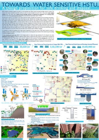
- 1. •Water Supply •Sanitation •Waste water Management •Storm Water Drainage •Reduces demand for external fresh water by reuse of grey water , black water, storm water Filtered water Aggregates Sand filter Unfiltered rain water Floating particles INTAKEWELL HIGHEST GROUND LOWEST GROUND PROPOSED BUILDING EXISTING CAMPUS TERRAIN EXISTING CAMPUS PREVIOUS WATER FLOW OF HSTU TOWARDS WATER SENSITIVE HSTU,A Design proposition for safe drinking and disposal……. CONSUMPTION OF WATER IN HSTU Agricultural ExtensionTraining Institute (AETI) (1976-1987) Hajee Mohammad DaneshAgricultural College(1988-1998) Trainee 150 person Instructor 5-10 person Office staff 5-10 person HajeeMohammadDaneshScienceandTechnologyUniversity(1999-present) students 200 person teachers 50 person Office staff 30-40 person students 11,0000 teachers 315 persons Office staff 250 persons30,600 Ltr 3,50,190 Ltr 10,80,900 Ltr PRESENT LAND SITUATION WITH RESPECTTO PREVIOUS Heavey rainfalls(1.5- 2days) Logging height nearly reach around 10- 12 inch 10-12 hours continuous rain and it became unable to stay here Heavey rainfalls(1.5-2days) Logging height nearly reach around 10-12 inch 10-12 hours continuous rain and it became unable to walk Unworthy for walking even in light shower Unworthy for walking even in light shower 10-12 hours continuous rain and became unable to walk Logging for light rain Logging for medium rain(10-12 hour min) Logging for heavy rainfall(1.5-2 days) Unworthy for walking even in light shower TUBEWELLWITH SOAK WELL CONTAMINATED ZONE ZONE 30 -50ft horizontally ( According to BNBC this zone is risky ) Above 60 ft ) WATER SENSITIVE URBAN DESIGN (WSUD) APPROACH PRE-TREATMENT NATURALTREATMENT NECESSERY INFRASTRUCTURE •BAR SCREEN •SANDTRAP •WASTE STABILIZATION POND •WETLAND •PATHWAY •DRAIN •WATER RECHARGE PIT LEGEND SAND TRAP GRIT CHAMBER SEDIMENTATION TANK COVER BAR SCREENS SAND TRAP REF: Trash rake project, Northern california WASTE STABILIZATION PONDS SECTION 3D SPATIAL VISUALIZATION OF STABILIZATION POND BANGABANDHU HALLZIA HALL PROPOSED HALL 3D SPATIALVISUALIZATION OF WET LAND INTAKEWELL RECHARGEWELL ACADEMIC BUILDING-1 RECHARGE PIT 3D SPATIAL VISUALIZATION •To remove the suspended solids •To avoided the pump cloaking •To increase the Bacteria attachment in the FBBR SAND TRAP SECTION •Removal of sand, gravel and other substances.To reduce the flow rate in the tank HSTU campus is located at basher hat, which is a non-municipal area. Where central municipal drainage network is absent. The campus area is also concealed by boundary wall so no water can pass through this area. For this in rainy season water logging problem occur. The waste water dispose area & drainage network is unplanned & inadequate. Some drinking water sources are also being contaminated by soak pit.This are the essential issues about water in HSTU. The land area is same as it was before on the other hand the number of people has increased. For this increasing consumption , waste water is also increased almost three times. But the water disposal area, drainage system remains almost same. The percentage of rain fall here is around 1728mm yearly. 20.21% hard surface of hstu, reduce it’s natural draInage . so mainly in the rainy reason water logging problem is common scenario. There are two main water disposal area. So what happens here storm water easily mixed with the grey water and also for improper management of soak pit and septic tank black water easily mixed with grey water. Again these grey water discharged to the environment without treated, it easily contaminates with the ground water and make it risky for drinking. So to understand the problem it is essential to communicate with the people who lived here before and also with the present users for some mental mapping. To learn about the risk zone and contaminate tubewell zone, its important to survey the whole area and collect some necessary data for different mapping. It is essential to reduce the pollutant from waste water & separation of rain water from it. Rain water should be reused or sending it directly to the aquifer to recharge it. To reduce the loss of existing plants and animals of this wetland and surroundings it should be designed properly. So bar screening and sand trap added in the drainage system to reduce the large pollutants. For the disposal area waste stabilization pond, wetland provided for sediment. Aquatic plants to absorb the heavy metals for maintaining the ecosystem & to recharge ground water. These water can be used for irrigation & other purposes. Providing recharge pit to send the rain water directly to the aquifer & it also reduce water logging. Increasing the distance between soak pit and drinking water sources to ensure better health. Pathway for little water logged area, landscaping for better visualization of wet land area . CENTRAL SUPPLY CENTRAL SUPPLY + INDIVIDUALMOTOR INDIVIDUAL MOTOR TUBE-WELL PUMP HOUSE “ A L L W AT E R I S A N O P P O RT U N I T Y N OT A T H R E AT ” EXISTING WATER DISTRIBUUION MAP •Wastewater-fed earthen basins growing with algae + fish •Due to difficulties in algal harvesting :use fish to consume •Algae : O2 for fish and bacteria •Bacteria :CO2 for algal photosynthesis + degrade organic MAPING OF PROPOSED ELEMENTS STORMWATER LOGGING MAP W E T L A N D S E C T I O N • A wetland is an area that is saturated with water or covered by water for at least one season of the year • They provide a safe, lush habitat for many species of animals, so they have high biodiversity. • They provide a safe, lush habitat for many species of animals, so they have high biodiversity. 3D SPATIALVISUALIZATION RECHARGE PIT RECHARGE PIT SECTION 3D SPATIALVISUALIZATION OF PATHWAYS