
Empfohlen
Weitere ähnliche Inhalte
Was ist angesagt?
Was ist angesagt? (20)
Ähnlich wie Landscape Record - Urban Renewal and Regeneration
Ähnlich wie Landscape Record - Urban Renewal and Regeneration (20)
Kürzlich hochgeladen
Kürzlich hochgeladen (20)
Landscape Record - Urban Renewal and Regeneration
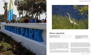
- 1. 1. A monument sign, located at the northwest corner of the park, uses details found in the historic building architecture nearby and is positioned as a vertical barrier between the street and a large plaza space. 2. A Great egret (Ardea alba) finds protection and food along the banks of lake. 1 Landscape Architects: AECOM Location: St Petersburg, Florida Mirror Lake Park On May 23, 2014, the City of St. Petersburg Florida celebrated the re- opening of one of their downtown signature parks. The day was warm and full of sun, a calm breeze was making its way across Mirror Lake as the City Mayor and other elected officials began to tell stories of their own experiences with the park. As the dedication ceremony was coming to an end, it was clear that this park meant something different to each person that experienced it. This area was dedicated as a park over 100 years ago and continues to evolve into a place that relates to the social, economic and ecological forces of today. This park, like many parks located within urban areas, has the potential to serve as the community gathering space, a place for recreation, relaxation and a place that tells a story of the area. Urban parks also have the power to position the adjacent areas for positive economic growth. This park is uniquely positioned to have a positive impact on the local community while providing ecological benefits for the local wildlife. Many bird species reside here throughout the year and provide a wild setting to this urban area. Visitors of the park are often seen taking pictures and getting close to birds and water fowl. Turtles and various species of fish can also be found here. The downtown parks and waterfront parks were being established as the city began to grow. As the City of St Petersburg was developing into a viable town in the late 1800’s, the City’s drinking water was sourced from Reservoir Lake, now known as Mirror Lake. Mirror Lake was the city’s first municipal water supply until 1908. In 1898 the lake was guarded after attempted poisoning by the Spanish (it supplied water to the port of Tampa 2 INSIGHTS 86 87 URBAN RENEWAL AND REGENERATION Landscape Record Vol. 3/2016.06Landscape Record Vol. 3/2016.06
- 2. 3 1 2 1 2 3 4 5 6 7 8 9 11 9 1 14 15 12 11 13 10 PLAN 1. New park sign 2. Relocation of aboveground utilities 3. Downtown views 4. Decking over existing storm pipe 5. Existing tree 6. Proposed tree 7. 6’ wide walk 8. Native aquatic plants 9.10’ wide walk / shared path 10. Historic building views 11. Screen cars from views across the lake 12. Generator & fuel tank 13. Limb up tree for views to lake 14. Plaza / paddle boat launch area 15. Low ground cover The park master plan identifies areas around the lake for community gathering, great views to downtown and opportunities to get close to the water's edge. 1. Many large trees have been preserved around the lake. These trees frame views from a nearby bench looking across the lake to the historic buildings. 2. The contiguous multi-use trail around the lake allows residents and visitors to utilize this park for exercise. 3. The Mirror Lake Lyceum, a Mediterranean revival style building was originally constructed in 1926. Project Name: Mirror Lake Park Completion Date: 2014 Client: Steve Ochsner, City of St Petersburg, Florida Size: 5.6ha Photography: Michael Brown – AECOM troops and ships). It became a city park in 1912 and has been the geographical center for many of the public and recreational facilities in downtown. St Petersburg has a vision to be a place of opportunity where the sun shines on all who come to live, work and play in the community. The city has long been a place of a lifestyle for the retirees and tourists and still retains much of the resort- town flavor its founders loved. Much of the year is showered with sunshine and is a haven for outdoor water-oriented activities and an easy-going lifestyle. INSIGHTS 88 89 URBAN RENEWAL AND REGENERATION Landscape Record Vol. 3/2016.06Landscape Record Vol. 3/2016.06
- 3. 1 2 3 Mirror Lake Downtown waterfront parks Tampa Bay A diagram illustrating the park's close proximity to Central Avenue, the city's main retail street. Many historic buildings are also near the park. A figure-ground diagram shows the connections from Mirror Lake to downtown and the city's waterfront parks. The City of St. Petersburg, Florida selected AECOM to develop Design and Construction Documents for a pedestrian sidewalk/trail around Mirror Lake. Prior to the development of the Construction Documents, AECOM conducted a public workshop to gather public input for both the Mirror Lake Park improvements and the areas adjacent to Mirror Lake. This workshop facilitated the preparation of the conceptual master plan for the Mirror Lake area. These park improvements will make a lasting positive impression on this community. Prior to the redesign of the park, this area felt unsafe for local residents and visitors. A narrow sidewalk surrounded only a portion of the lake and did not make a full loop. The absence of a contiguous path around the lake created problems for people using this area for exercise as they would need to turn around at some point and not have access to the east side of the lake. Park furniture and signage was outdated and not being used by the general public. The overgrowth of trees and shrubs made visual and physical access to the water difficult and lighting was not sufficient and left people feeling unsafe to be out at night. The historic buildings that surround the lake create an identity that is special to this area of the city. This special identity was often lost by the park’s tired character. The adjacent community spaces and recreational facilities did not have a park space to spill into during special events. Weddings would often be seen taking place at the Lyceum Building but the wedding party did not have a place in the park for pre-functions and gathering. The Shuffleboard Club’s Friday night events would also be confined to their property’s boundaries and not have the ability to use the park for special functions. The brick street and granite curbs surrounding the park gave cues to the history of the area. 1. A secondary sidewalk brings park visitors closer to the water's edge. Birds and aquatic wildlife can be seen from these locations. 2. The wide sidewalk splits into two narrower walks and allows park users to choose a different experience around the lake while preserving a large live oak tree. 3. Small sign markers are located around the lake at key pedestrian crossings to help identify the park. INSIGHTS 90 91 URBAN RENEWAL AND REGENERATION Landscape Record Vol. 3/2016.06Landscape Record Vol. 3/2016.06
- 4. 3 41 2 An aerial oblique diagram illustrates the strong connection to downtown and the waterfront park system from Mirror Lake. 1. The park's main path is designed to accommodate many different users. This multi-use path creates a destination for the whole community to enjoy. 2. Individuals with unique abilities can be seen using the path around the lake. Encouraging the whole community to use this park is important to the city's mission to be a livable city for all residents and visitors. 3. Native grasses and trees are used to provide a buffer between the path and the lake while creating habitat for local wildlife. 4. Park users enjoy the outdoors while walking around the lake. Today, the park feels open, safe and welcoming to visitors and community residents. The most valuable addition to the park is the 10’ wide contiguous path that encircles the lake, welcoming park users to navigate around the entire lake. The city had made an agreement with a landowner on the east side of the lake to allow for a path to be constructed on their property that would continue the loop around the lake. This agreement was instrumental in the development of the park master plan and ultimately satisfied many of the community’s goals and desires of the future of their park. The views have been opened up by thinning or removing vegetation. Native trees, shrubs, grasses and aquatic plants have been planted throughout the park to provide shelter for migratory birds and decrease the amount of irrigation and fertilizers needed for plant survival. Lawn areas have been established as open green space for passive recreation and park visitors can enjoy city views from all sides of the lake, making this a dynamic area to walk around while taking in the views. At night, the park is illuminated with new lighting that provides the community with a safe environment in downtown to use. New park furniture and signage has been incorporated to provide a fresh new look to the park while respecting the historic nature of the surrounding area. A large plaza has been built at the northwest corner of the park overlooking the lake. This plaza is across the street from the Lyceum Building and has been used for weddings, community events and social gatherings. The plaza is paved with three different shades of clay brick, a low seat wall, monument signage and lighting. A smaller plaza has been built near the Shuffleboard Club at the northeast corner of the park and provides a gateway from downtown with its brick paving, seat wall and vertical monument park signage. The brick paving pattern for these plaza areas was developed by borrowing cues from nearby architectural details. Pedestrian crossings were also added to ensure safe crossings to the park INSIGHTS 92 93 URBAN RENEWAL AND REGENERATION Landscape Record Vol. 3/2016.06Landscape Record Vol. 3/2016.06
- 5. 5 3 4 1 2 1. A park user enjoys the outdoors while walking around the lake during lunch time 2. A park user enjoys the views to downtown while passing through a grove of trees. 3. A monument sign located at a small plaza space marks the northeast entrance to the park. 4. A Great egret (Ardea alba) walks near the lake edge. 5. A large plaza is used for community gatherings and outdoor functions from the Lyceum Building. The paving design draws from the architectural details of the nearby historic buildings. from adjacent buildings and streets. The brick streets and granite curbs have been preserved and serve as a reminder of the history of this area. This park also has physical connections to a successful retail street, Central Avenue. People using the park have only a couple blocks to walk to be in the middle of a bustling retail destination. The connections to downtown and the downtown waterfront parks are also important as the city continues to develop and grow. THE HISTORY OF NEARBY PUBLIC FACILITIES St. Petersburg Shuffleboard Club One of the most popular public recreational facilities near Mirror Lake was the St. Petersburg Shuffleboard Club. The clubhouse was built in 1927 with additions continuing until 1947. It was the first organized club to exist in the United States and is a valuable reminder of St. Petersburg’s popularity as a winter vacation destination. St. Petersburg High School at Mirror Lake The ca. 1919 Mission Revival structure exhibits subtle stylistic elements serving as the precursor to the Mediterranean Revival style. For 46 years it served as a public school and from 1967 to 1985 it served as the Mirror Lake Adult Education Center. It was designed by William Ittner, a nationally known architect who also designed the Tomlinson Center and St. Petersburg Central High School. St. Petersburg Carnegie Library The 1915 Carnegie Library is the City’s first permanent public library and was funded by a grant from Andrew Carnegie’s foundation, which had major impacts on the development of culture throughout America. The Henry Whitfield-designed Library is also significant for its Beaux Arts architecture, a rare style in St. Petersburg. Municipal Utilities Building (City Hall) The 1939 City Hall is one of the few buildings in the City constructed under Roosevelt’s Public Works Administration. The building retains its architectural integrity on both the interior and exterior. City Hall is the work of nationally known architect A. Lowther Forrest, prominent local contractor R.E. Clarson and City Engineer Paul Jorgensen. Snell Arcade The 1928 Snell Arcade was designed by Richard Kiehnel for Perry Snell, St. Petersburg’s preeminent developer during its early years. The arcade is an excellent example of Mediterranean Revival architecture, a style for which Kiehnel is attributed with bringing to Florida in his design of El Jardin in Miami in the 1910s. He also designed the Rolyat Hotel in Gulfport, which now serves as the campus for Stetson Law School. Coliseum Mediterranean Revival style structure is a prominent dance hall and entertainment facility from 1924. The building was designed by T.H. Eslick and developed by C.F. Cullen and has attracted big name entertainers throughout its history. INSIGHTS 94 95 URBAN RENEWAL AND REGENERATION Landscape Record Vol. 3/2016.06Landscape Record Vol. 3/2016.06
- 6. This image, taken in 1907, shows the Rail Pier being used for fishing and as a large boat dock facility. 1926 Municipal Pier and Yacht Basin was a popular destination for the community. 1936 aerial image shows downtown and the waterfront land being converted into public park space. A group of local citizens walk together during a “walking audit” of Lassing Park. A citizen provides the design team with her hopes and dreams of the future of the downtown waterfront during the public kickoff event. Local youth are given the opportunity to describe what activities they would like in their waterfront parks. Historic Context The Downtown Waterfront has long served as the city’s greatest physical asset. First settled in 1888 by Peter A. Demens at the terminus end of his Orange Belt Railway, the Downtown Waterfront quickly developed with industrial land uses including an electric-generating plant, fish processing plant, lumberyard and numerous warehouses. By 1900, these industrial activities so disfigured the Downtown Waterfront that a conflict with the growing tourist trade ignited civic interest in a publicly owned Downtown Waterfront. In 1902, debate over the future of the Downtown Waterfront began when the Board of Trade, a predecessor to the Chamber of Commerce, approved a resolution calling for a public waterfront park between2nd and 5th Ave. N. The resolution was backed by William Straub, editor for the St. Petersburg Times, who made creation of the waterfront park system a key goal of his own ambition and professional publication. In 1905, J. M. Lewis presented a plan to convert nearly the entire Downtown Waterfront into a park. Lewis’ plan became a major issue in the 1906 city elections, and the public waterfront supporters eventually won a majority of the seats on the City Council. The new City Council quickly passed a resolution to acquire the waterfront and by the end of 1909 the city held title to most of the waterfront. As best as can be historically documented from reliable sources, most of the water lots were filled sometime between 1915 and 1919. The Florida Legislature passed Specials Acts in 1917 and 1918 granting title to the city for those submerged lands from Coffee Pot Bayou to approximately Lassing Park adjacent to the city-owned upland. The entire present day Downtown Waterfront was created by fill. Between the years of 1918 and 1923, the city acquired several remaining pieces of land and commenced significant improvements to establish scenic water vistas and public recreation opportunities. The value of the Downtown Waterfront was subsequently memorialized by a special provision in the City Charter requiring voter approval before any designated park property can be sold, donated, or leased for a term exceeding those lease terms specifically authorized for the waterfront or park properties. To protect, enhance and promote St. Petersburg’s Downtown Waterfront as one of the premiere waterfront destinations and attractions in the world, voters approved a City Charter Amendment in November 2011 mandating the creation of a Downtown Waterfront Master Plan. The Plan is intended to provide the first integrated vision for the city’s entire Downtown Waterfront and its many uses by establishing a master plan and policy framework of guiding principles for future decision making. The guiding principles are represented in the Master Plan as the Five Dimensions Transforming St Petersburg’s Downtown Waterfront By Michael J. Brown of the Waterfront, the Comprehensive Waterfront Needs, and the six District Concept Plans. AECOM Selection as Citizen-based Design Experts AECOM was selected to develop a citizen-based Downtown Waterfront Master Plan for the City of St Petersburg FL. The existing waterfront is underutilized and serves only a few different users. The city’s growth downtown has diversified the area and the waterfront is set up to be the premier space to respond to this diversification. This growth is creating pressure for the waterfront to be a facility for all citizens of the community. The Downtown Waterfront Master Plan is a comprehensive and inclusive planning project that leveraged the community’s love for their waterfront as a place for all citizens to enjoy. The plan was developed through extensive public outreach and community involvement. Community themes were developed by the project team and confirmed by the public, to provide the framework for the Master Plan. As such the master plan is guided by the following overarching community themes, the five dimensions of the waterfront: • Stewardship of the Waterfront Environment • Enhancing the Experience of the Water • An Active Waterfront Parks System • Economically Vibrant Downtown Places • A Connected, Accessible Downtown + Waterfront The Master Plan is structured to address the community’s short-term baseline needs, locations for targeted enhancements and identify areas for long-term transformative change. This framework is applied to the varying place types along the beautiful seven miles of waterfront. Public Input Gathering input from the public and various stakeholder groups was conducted with a variety of methods including a kickoff event, four walking audits, five community meetings, four community outreach meetings, an interactive youth workshop, over 20 stakeholder meetings, a survey, and various forms of online outreach. The Public Kickoff Event marked the beginning of the outreach process for the Downtown Waterfront Master Plan. The general public was invited to attend the event to become informed about the planning process and to provide feedback to guide the plan. Deputy Mayor Dr. Kanika Tomalin addressed the crowd of approximately 300 to kick-start the discussions about creating a vision for the waterfront. Brochures and other takeaways were provided so participants could take home information about the Downtown Waterfront Master Plan to share with family and friends. Throughout the night, event attendees discussed their hopes and concerns for the Downtown Waterfront. During the public input process, all citizens were invited to walk different areas of the downtown waterfront as an on-site, interactive technique for identifying concerns of public and private space related to access, connectivity, safety, use and economic opportunities. DESIGN EXCHANGE 114 115 URBAN RENEWAL AND REGENERATION Landscape Record Vol. 3/2016.06Landscape Record Vol. 3/2016.06
- 7. Walking audits are a useful tool for public input when developing a plan because they involve the public and work as a sort of hands-on demonstration of the strengths and weaknesses of an area on-the-ground for the project team. Walking audit participants walked a predetermined route as a group, stopping occasionally to evaluate characteristics people wanted to discuss along the way. Participants completed a survey while they walked to record their observations in a structured manner. A Youth Workshop was held at a local Recreation Center to allow the youth of the community to voice their opinions of what their dream waterfront would look like and the different activities they would like to see. The AECOM team briefly described the Downtown Waterfront Master Plan and highlighted the importance of their input to the planning process. The group was asked a series of questions about the future of the Downtown Waterfront. The participants discussed their thoughts about the waterfront including what they would like to change and things they like to do there. After the discussion, the groups participated in the park design activity and presented their table’s ideas to the project team. Pictures of typical activities and amenities commonly featured on great waterfronts were given to the participants along with an aerial view of Spa Beach Park. The participants were asked to cut out the pictures of things they wanted to see in that park and “design” the park by gluing the pictures to the aerial photo. Some participants chose to supplement the pictures with drawings in marker. Collage maps prepared by the participants are shown to the right. The participants presented their finished ideas to the larger group. In an effort to reach the widest possible audience for this outreach effort, the project team developed a website that contains background information, related plans and reports, maps, schedule and other up-to-date project-related information. Additionally, the city’s Facebook and Twitter feeds were used for announcements and brief highlights of activities in real time for the project. The centerpiece of the project’s digital communication efforts is StPeteInnovision.com. This website acts like a “Digital Town Hall” where community members can sign up, discuss specific topics and questions, upload pictures, and provide their own ideas as well as comment and discuss the ideas submitted. If a user sees an idea or comment they agree with, they are invited to award a point to that post. Rewards are offered for various levels of participation. As the planning process continues, this forum will continue to allow the public to provide feedback as the project evolves. An Interest and Opinion Survey was conducted on the St. Petersburg Downtown Waterfront in the Fall of 2014 to help establish priorities for the waterfront. The survey was designed to obtain statistically valid results from households throughout the City of St. Petersburg. The survey was administered by mail, web and phone by ETC/Leisure Vision, a leading community-based market research firm. A five-page survey was mailed to a random sample of 2,500 households throughout the City of St. Petersburg. Approximately three days after the surveys were mailed each household that received a survey also received an automated voice message encouraging them to complete the survey. In addition, about two weeks after the surveys were mailed the survey team place in large gatherings, in small groups, in walks through neighborhoods, and online through the St. Pete InnoVision website and other social media outlets. The conversations often included observations, general concerns, values, and specific ideas for change. The suggestions and ideas generated from these meetings can be classified into the Five Dimensions of the waterfront: 1. Stewardship of the Waterfront Environment 2. Enhancing the Experience of the Water 3. An Active Waterfront Parks System 4. Economically Vibrant Downtown Places 5. A Connected, Accessible Downtown and Waterfront began contacting households by phone. Those who had indicated they had not returned the survey were given the option of completing it by phone. The goal was to obtain a total of at least 500 completed surveys. The survey team met that goal with a total of 694 surveys completed. A total of 492 surveys were completed from residents located on the waterfront and 202 surveys were completed from residents located outside of the waterfront. The results of the random sample of 694 households have a 95% level of confidence with a precision rate of at least +/-3.7%. The Waterfront Planning Begins During the several months public input process, the project team listened to hundreds of residents, business owners, community leaders, and many others interested in the future of St. Petersburg’s Downtown Waterfront. These conversations took Each of these topics has specific issues associated with it that will drive the planning process. To better understand the component issues, they can be divided into three levels of enhancement, described below. Transformative Change - Transformative Changes are long-term, large- scale changes to the waterfront that have greater importance to the city and region. These changes may include improvements like increasing the size or quality of natural habitat, creating additional breakwaters to improve the functionality of the marinas, increasing multi-modal access to the waterfront and developing additional regional attractions on underutilized land. Targeted Enhancements - Targeted Enhancements are changes that can be implemented in a phased approach with additional funding partners to provide additional opportunities for activities at the waterfront. These changes may include improvements like increasing water circulation through the marina basins, providing more transient boat docks, building additional restrooms, concessions and water activities, and accommodating water transportation options. Baseline Needs - Baseline Needs are changes that can be implemented in the short-term at a relatively low cost. These changes may include implementing low-impact development guidelines to protect water quality, provide better facilities for human-powered watercraft storage and access, provide additional shade with Florida-friendly tree species, provide seating, trashcans, wayfinding and other amenities to make a better waterfront park experience and improving the quality and quantity of biking infrastructure. A Resilient Waterfront As a vision plan and framework for future growth, the Downtown Waterfront Master Plan focuses on enhancing the vibrancy of the core area within an A scientifically valid public survey provides the design team with important planning information. The North Shore Park and Beach areas have been identified as a place for targeted enhancements. A sketch of the Pier looking back to downtown. A living breakwater, shown in the foreground, helps mitigate storm surge while creating wildlife habitat. A sketch of the Pier looking back to downtown. A living breakwater, shown in the foreground, helps mitigate storm surge while creating wildlife habitat. DESIGN EXCHANGE 116 117 URBAN RENEWAL AND REGENERATION Landscape Record Vol. 3/2016.06Landscape Record Vol. 3/2016.06
- 8. urban context to further improve function and aesthetics while promoting economic vitality through private investment. The success of the plan is through thoughtful implementation from engaged stakeholders and leadership, and with continued input from the community, focused on integrating the natural, built and social environments within each improvement project. This integration provides the platform to leverage natural systems enhancing the waterfront user experience while offering protection against natural hazards resulting from a changing environment. This whole system integrated planning approach is critical to increasing the resiliency of the St. Petersburg’s downtown waterfront and allowing the vision to be realized. Utilizing a flexible, adaptable and well-informed set of guiding principles comprised of relevant and implementable mitigation strategies provides the City with the confidence necessary to grow in the face of future uncertainty. The Downtown Waterfront Master Plan offers an opportunity to move the City towards resiliency and to protect natural and man-made assets through integration of adaptive planning strategies and to begin cultivating a paradigm shift related to living with the natural environment. The plan also provides a platform to elevate the resiliency discussion and inform the community of its importance for the future of the City. The Downtown Waterfront project area is approximately seven miles in length and is comprised of many different parcels, ownership, uses and community values. The master plan has identified a series of special distinct areas along the length of the Downtown Waterfront. These areas have been identified as Character Districts. This plan provides recommendations that fit within the context of each distinct district. Respecting these different areas will result in a more diverse, interesting and sustainable Downtown Waterfront. Park Improvements One of the consistent values identified in the community meetings was the ability to spend the day in the park. St. Petersburg should provide improvements and enhancements to the park to create a more comfortable place for recreation. A park visitor should have varying levels of activities to choose from and feel safe and comfortable during daytime and evening hours. Shade, seating, lighting, and drinking fountains should be included in baseline treatments to meet the needs of the community. An activity node has been identified at the existing restroom facility and should include small concessions for food sales and rentals of small craft and sporting equipment. Picnic shelters should also be located at appropriate activity nodes to provide visitors with a shaded environment to enjoy. hotel. The Al Lang Stadium block, from 2nd Ave. S to 4th Ave. SE, should also be redeveloped with sports-associated program, and ancillary retail and commercial uses. This concept has many site design issues that will require creative solutions to realize the goal of a vibrant, walkable mixed- use area. Any revenue created by this type of development can be put back into improvements of other public spaces along the waterfront identified in this Master Plan. Advancing this concept from idea to reality may be subject to certain deed restrictions and may require referendum approval; as such, a proactive community engagement process must be undertaken to ensure transparency. Improving Pedestrian and Bicycle Connectivity To connect Lassing Park to the Bayboro & Salt Creek District, a multi- purpose trail should be constructed along the waterfront from the northern border of Lassing Park along the shore between the Army Reserve station and the Coast Guard station to the Bayboro & Salt Creek District. This will require negotiation with the defense agencies which operate facilities here and may involve land swaps or special design considerations for security purposes. Regardless of the specific structure of the agreements which allow for the creation of the trail, such a connection would allow continuous waterfront access to Lassing Park from the north. Stormwater Enhancements Careful consideration should be made while evaluating stormwater outfalls and park space. A small percentage of underutilized green spaces should be dedicated to environmental enhancements within the parks. Locating stormwater basins adjacent to the source will reduce pipe length and costs and also reduce the footprint of the basin. A treatment train approach of smaller basins should be considered to not disturb large areas of park land. Reconfiguring the Sports, Culture and Entertainment Zone Redevelopment opportunities should be pursued adjacent to the Mahaffey Theater and Dali Museum. The existing surface parking lots should be re- examined as opportunities for redevelopment potential. The area located west of the Dali and south of the existing parking garage should be reserved for Dali expansion of roughly 65,000sf of space. The existing parking garage could accommodate parking for the Mahaffey, the expanded Dali, other cultural and civic uses and ancillary retail. Areas north of the parking garage and south of 4th Ave. SE could be redeveloped with uses that complement the Mahaffey and Dali, such as additional cultural and civic uses and ancillary retail at the street level. Civic uses do not include a conference center or A sketch plan identifies new buildings, shown in red, as redevelopment opportunities. An activity node has been identified near the Bay at the North Shore Park and Beach area. Park areas converted into shallow planted basins to collect and treat stormwater before entering the Bay. A pedestrian bridge provides an important linkage from downtown to the working waterfront area of the city. Urban runoff flows directly into the Bay. Service streets have been transformed into public plazas and shared space around the various sports, culture and entertainment venues. Certain streets have been identified as important linkages to downtown. Linkages are converted into complete streets that encourage multi-modal transportation uses. DESIGN EXCHANGE 118 119 URBAN RENEWAL AND REGENERATION Landscape Record Vol. 3/2016.06Landscape Record Vol. 3/2016.06
- 9. Michael J. Brown, PLA Landscape Architect Michael J. Brown is a landscape architect with AECOM. He has experience with various types of landscape architecture projects including park design, streetscapes, civic building landscapes, healthcare facilities, campus environments, urban design, mixed- use and urban infill development. Michael’s design and construction experience is featured in various locations in Central Florida and Seattle, WA. Many of these projects are examples of Michael’s interest and ability to design outdoor spaces that are both socially and environmentally sensitive. Mr. Brown has special interest in sustainable infrastructure and often finds way to incorporate green design into projects in a cost- effective manner. Connections between Lassing Park and downtown are restricted geographically by Salt Creek and Bayboro Harbor. To improve connectivity for the non-motorist, a shared-use trail should be constructed along 3rd St. S to improve the north-south connections to the Lassing Park area. This will provide a safer and more comfortable journey and encourage the use of non- motorized transportation within the Downtown Waterfront. Expand Pedestrian/Public Edges Similar to the Pier Approach, this area of the city also has a car-dominated edge. Shifting cars away from the edge and giving this space to pedestrians will create a more friendly and inviting environment. This plan does not state that all parking should be removed but rather shifted away from the edge. The USFSP Peninsula has other areas to park cars and these areas need to be considered as part of this plan to make a more walkable, livable and hospitable environment for people. In Summary The St. Petersburg Downtown Waterfront Master Planning process was focused on facilitating a community conversation about the future of St. Petersburg’s world-class waterfront. This plan was created with the input of thousands of interested citizens, and is dedicated to bring their shared vision to life. The products of this plan will lead to a future with greater opportunity for people of all walks of life to enjoy their waterfront and for the waterfront to contribute to the vitality of their community. The Baseline Needs, Targeted Enhancements, and Transformational Change provide an approach to prioritize public projects. As the plan is implemented, new challenges may arise whose potential solutions can be examined through the approach described by this plan. The plan calls for changes to the public, institutional, and private land along the waterfront. Property ownership involves many players to bring together some of the concepts in this plan. As individual properties are redeveloped or public facilities are updated, the opportunity to address baseline needs should be explored. This could be as simple as restriping bike lanes when an underground utility is opened for maintenance or it could be a long-term strategy to systematically address a need identified in this plan across the waterfront. The challenges at the waterfront are significant, but there are many areas where people, institutions and the city have already come together to create great places at the Downtown Waterfront. Past successes indicate the importance of the public, private and institutional sectors working together towards a common vision. This planning process has created a framework that will allow the city to take a facilitating role to implement the shared vision for the waterfront. Private developers should be sensitive to the role they play in creating a successful waterfront because they realize that development compatible with this plan will bring greater economic success to themselves and the city as a whole. To achieve the vision outlined within this document, city, institutional, and private sector leaders need to support this framework plan to achieve success. St. Petersburg is fortunate to have such a magnificent natural resource with its shoreline along Tampa Bay. And the success of the city has undoubtedly been influenced by the wise decisions made in the past by the city’s founders. Today, the legacy of insightful leadership from the public and private sectors continue to nurture the Downtown Waterfront into the future. It will be a public resource that serves the people of the City of St. Petersburg and visitors from around the world for generations to come. An existing waterfront edge dedicated to the automobile. The Pier District is transformed into a pedestrian oriented festival space along the water’s edge and extending out to the Pier. The city’s working waterfront is transformed into a destination district that showcases the city’s maritime history. Clear connection to downtown makes this an attractive area for development. All images courtesy of AECOM The Pier District is transformed into a pedestrian oriented festival space along the water's edge and extending out to the Pier. DESIGN EXCHANGE 120 121 URBAN RENEWAL AND REGENERATION Landscape Record Vol. 3/2016.06Landscape Record Vol. 3/2016.06