Math in the News: 10/3/11
•Als PPT, PDF herunterladen•
1 gefällt mir•456 views

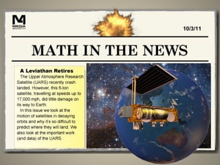
The Upper Atmosphere Research Satellite (UARS) was launched in 1991 to study the ozone layer. It collected data that showed levels of ozone-depleting chemicals had stabilized by 2005, when UARS was decommissioned after exceeding its planned 3-year mission lifetime. As a satellite's orbit decays due to drag from solar wind and atmosphere, it is difficult to predict exactly where it will re-enter and debris will land, within a margin of about 4,280 miles, due to uncertainties from atmospheric effects.

Empfohlen
Weitere ähnliche Inhalte
Was ist angesagt?
Was ist angesagt? (20)
Ähnlich wie Math in the News: 10/3/11
Ähnlich wie Math in the News: 10/3/11 (20)
Mehr von Media4math
Mehr von Media4math (20)
Kürzlich hochgeladen
Kürzlich hochgeladen (20)
Math in the News: 10/3/11
- 1. 10/3/11
- 2. The UARS Satellite • The Upper Atmosphere Research Satellite (UARS) was launched in 1991. Its mission was to study what at the time was termed the “ozone hole” in the upper atmosphere.
- 3. The UARS Satellite • To learn more about the UARS Satellite, go to the NASA archive and search for UARS. Go to http://www.nasa.gov/multimedia/vid Search for: UARS.
- 4. The UARS Satellite • As a result of the data obtained from the UARS, global levels of CFCs have reached a plateau since the satellite’s launch. Launch of UARS
- 5. The UARS Satellite • The UARS was decommissioned in 2005. Since it was originally scheduled for a three-year mission, it outlived its mission by over a decade. • When decommissioned a satellite is allowed to continue its orbit, but with no further intervention.
- 6. The UARS Satellite • We think of space travel as movement through a vacuum. If this were really the case, then given enough energy, a satellite would continue orbiting the Earth indefinitely.
- 7. The UARS Satellite • But a satellite, like any other spacecraft, is subject to solar wind, which is made up of subatomic particles and photons. Like the wind that can slow down an airplane, solar wind acts as a drag on the motion of a satellite, slowing it down.
- 8. The UARS Satellite • As the satellite slows down, its orbit around the Earth shrinks. The is an example of a decaying orbit.
- 9. The UARS Satellite • If solar wind was a drag on the satellite, even more dramatic changes occur when the satellite enters the Earth’s atmosphere. Here, a much more dense collection of gases and other particles not only slow down the satellite but eventually cause it to break apart.
- 10. The UARS Satellite • This is where it becomes difficult to predict where the satellite will ultimately land. There are two main reasons for this. Let’s look at the first.
- 11. The UARS Satellite • There are a number of detectors around the Earth. As the satellite passes each detector, its expected path past the next detector is determined. When the satellite is not detected, that means it descended somewhere between the two detectors. So, there is a margin of error introduced.
- 12. The UARS Satellite • The second reason that it becomes difficult to predict the satellite’s descent is the Earth’s atmosphere, which changes the path of the satellite. Imagine throwing a paper airplane past a fan. You cannot accurately predict where the airplane will land because of the deflection from the fan.
- 13. The UARS Satellite • As a result, there is a degree of uncertainty about where exactly a satellite’s begins its descent. Let’s estimate that this uncertainty is 15 minutes in duration. Let’s also assume that the satellite is traveling at a speed of 17,000 mph.
- 14. The UARS Satellite • Now let’s assume that the satellite is at an altitude of 100 miles when it begins its descent. We can use this freefall function to determine the range of where the the satellite debris will land. (All distance units shown are in feet.)
- 15. The UARS Satellite • Solve this quadratic equation for t to find out the time the satellite will be in the air before it comes to a crashing halt.
- 16. The UARS Satellite • Use this value for t to find the horizontal displacement of the satellite. One it enters the atmosphere its speed is no longer 17,000 mph. Assume a horizontal speed of 600 mph.
- 17. The UARS Satellite • So the total range of where the satellite can land has increased to 4,280 miles.