SlideShare ist ein Scribd-Unternehmen logo
1 von 1
We thank the Office of Research and Sponsored Programs for supporting this research, and Learning & Technology Services for printing this poster.
INTEGRATION OF ATMOSPHERIC SENSORS
INTO UNMANNED AERIAL VEHICLE
PLATFORMS
Matthew Kennedy1, Patricia Cleary2, Peter Bui1, Joe Hupy3
1. Department of Computer Science, UW-Eau Claire 2. Department of Chemistry, UW-Eau Claire 3. Department of Geography and Anthropology, UW-Eau Claire
Applications of Unmanned Aerial Vehicles (UAVs) are being
investigated at University of Wisconsin-Eau Claire as part of a
Geospatial Education Initiative. The development of a UAV
capable of monitoring atmospheric properties (temperature,
humidity and wind) and composition (ozone) is underway. The
integration of temperature, humidity, and ozone sensors onto a
fixed wing UAV poses several problems with respect to electrical
power, weight, data acquisition and data storage. One strategy
requires the implementation of a central micro-controller for
onboard data acquisition and storage. The goal for full integration
of sensor control and data acquisition is for real-time data output
through the on-board auto-pilot feature so that the UAV flight
can be adjusted for observed atmospheric conditions. The
development of the auto-pilot/telemetry feature will also be
discussed.
Image 1 - RV Jet on trial flight with Personal Ozone Monitor in payload. Result : Crash
ABSTRACT
USING ADDITIONAL EQUIPMENT TO SEND SENSOR DATA
One of the end goals is to receive our external sensor data in real-time. This
is possible, as the autopilot already uses several external sensors to
determine its position, speed, etc. In the software exists an exploit that
should allow us to send sensor data in real-time by simply changing a few
select lines in the source code. We will utilize a structure already put in place
that would normally relay sonar data. Since we are not using sonar for this
project, it lends itself perfectly to this application.
INTEGRATION SOLUTIONS
• HMP-60 for temperature/humidity
• 5-hole probe for wind velocity
• Ozone sensor
In addition to the authors of this poster were co-collaborators working
on all other aspects of this project. Max Lee, Physics, made all telemetry
systems and oversaw the building of multiple UAVs. Joe Oster,
Chemistry, takes the data retrieved from the sensor packages and uses
that data to answer questions related to atmospheric environments
that he is studying.
PROJECT OBJECTIVES
Image 2 - RV Jet with radio transmitter and ground station
ENGINEERING CHALLENGES
USING EXISTING EQUIPMENT TO SEND SENSOR DATA
The first approach used to analyze data was to use an Arduino micro-
controller to gather sensor data and store it onto an SD card. This is a very
effective method for logging data, but for real-time analysis it is weak. In
addition a method utilizing GSM communication was hypothesized for near
real-time data transmission.
ACKNOWLEDGMENTS
INTEGRATE SENSORS INTO UAS
GATHER DATA IN A DYNAMIC ENVIRONMENT
Traditionally, atmospheric data has been gathered in a static
environment such as a weather station . Integrating similar
sensors into a UAV will allow a much more dynamic view of
atmospheric activity.
GATHER DATA IN A REAL TIME
Post-processed data can be useful for testing certain hypothesis,
but to allow for on-the-fly flight path changes, real-time data must
be transmitted. This will allow for instant recognition of
anomalous zones.
Gathering data is easy. Engineering a system to communicate that data
in an efficient way, especially in real-time, is not. A lack of similar
projects to reference also made things more complicated. When trying
to integrate into a finely tuned system like a UAV, you must be careful
not to have any kind of interference, especially with parts directly
responsible for flight and navigation.
FUTURE CHALLENGES
• Configured hardware to read sensor data
• Wrote software to send serial data to logger
• Fit hardware into already full payload.
• Increased precision by adding external ADC.
• Rewrite module to show data in Mission Planner
• Integrating ozone sensor more fully
• Write software to easily combine multiple data logs.
• Write additional module to show real-time data for multiple
sensors.
PROJECT MILESTONES
CURRENT HURDLES
• Compiler issues - Since source code needs to be changed,
firmware must be compiled and flashed to the autopilot
• Large learning curve to software already written.
• Extremely interdisciplinary experiment, which requires a
specially-designed, novel solution, so there is no “manual”

Weitere ähnliche Inhalte

Was ist angesagt?

Air quality challenges and business opportunities in China: Fusion of environ...
Air quality challenges and business opportunities in China: Fusion of environ...Air quality challenges and business opportunities in China: Fusion of environ...
Air quality challenges and business opportunities in China: Fusion of environ...CLIC Innovation Ltd
 
Hong Liu CanWEA presentation
Hong Liu CanWEA presentationHong Liu CanWEA presentation
Hong Liu CanWEA presentationmtingle
 
INTRODUCING NREL’S BEST PRACTICES HANDBOOK FOR COLLECTION AND USE OF SOLAR RE...
INTRODUCING NREL’S BEST PRACTICES HANDBOOK FOR COLLECTION AND USE OF SOLAR RE...INTRODUCING NREL’S BEST PRACTICES HANDBOOK FOR COLLECTION AND USE OF SOLAR RE...
INTRODUCING NREL’S BEST PRACTICES HANDBOOK FOR COLLECTION AND USE OF SOLAR RE...Roberto Valer
 
Simplify your data collection workflow - Em60G Webinar
Simplify your data collection workflow - Em60G WebinarSimplify your data collection workflow - Em60G Webinar
Simplify your data collection workflow - Em60G WebinarMETER Group, Inc. USA
 
SFScon17 - Markus Neteler: "Leveraging the Copernicus Sentinel satellite data...
SFScon17 - Markus Neteler: "Leveraging the Copernicus Sentinel satellite data...SFScon17 - Markus Neteler: "Leveraging the Copernicus Sentinel satellite data...
SFScon17 - Markus Neteler: "Leveraging the Copernicus Sentinel satellite data...South Tyrol Free Software Conference
 
Forecasting commercial services from IrSOLaV - Luis Martin (IRSOLAV)
Forecasting commercial services from IrSOLaV - Luis Martin (IRSOLAV)Forecasting commercial services from IrSOLaV - Luis Martin (IRSOLAV)
Forecasting commercial services from IrSOLaV - Luis Martin (IRSOLAV)IrSOLaV Pomares
 
Classroom occupancy project
Classroom occupancy projectClassroom occupancy project
Classroom occupancy projectMengdi Yue
 
Two-year assessment of Nowcasting performance in the CASA system
Two-year assessment of Nowcasting performance in the CASA systemTwo-year assessment of Nowcasting performance in the CASA system
Two-year assessment of Nowcasting performance in the CASA systemgrssieee
 
Environment Information System
Environment Information SystemEnvironment Information System
Environment Information Systemwebhostingguy
 
The Seismic Hazard Modeller’s Toolkit: An Open-Source Library for the Const...
The Seismic Hazard Modeller’s Toolkit:  An Open-Source Library for the Const...The Seismic Hazard Modeller’s Toolkit:  An Open-Source Library for the Const...
The Seismic Hazard Modeller’s Toolkit: An Open-Source Library for the Const...Global Earthquake Model Foundation
 
ESCAPE Kick-off meeting - FAIR, Facility for Antiproton and Ion Research (Feb...
ESCAPE Kick-off meeting - FAIR, Facility for Antiproton and Ion Research (Feb...ESCAPE Kick-off meeting - FAIR, Facility for Antiproton and Ion Research (Feb...
ESCAPE Kick-off meeting - FAIR, Facility for Antiproton and Ion Research (Feb...ESCAPE EU
 

Was ist angesagt? (20)

My_final_pres
My_final_presMy_final_pres
My_final_pres
 
Air quality challenges and business opportunities in China: Fusion of environ...
Air quality challenges and business opportunities in China: Fusion of environ...Air quality challenges and business opportunities in China: Fusion of environ...
Air quality challenges and business opportunities in China: Fusion of environ...
 
Short-term solar forecasting based on sky images
Short-term solar forecasting based on sky imagesShort-term solar forecasting based on sky images
Short-term solar forecasting based on sky images
 
Hong Liu CanWEA presentation
Hong Liu CanWEA presentationHong Liu CanWEA presentation
Hong Liu CanWEA presentation
 
INTRODUCING NREL’S BEST PRACTICES HANDBOOK FOR COLLECTION AND USE OF SOLAR RE...
INTRODUCING NREL’S BEST PRACTICES HANDBOOK FOR COLLECTION AND USE OF SOLAR RE...INTRODUCING NREL’S BEST PRACTICES HANDBOOK FOR COLLECTION AND USE OF SOLAR RE...
INTRODUCING NREL’S BEST PRACTICES HANDBOOK FOR COLLECTION AND USE OF SOLAR RE...
 
24 mavromatakis vignola_spectral_corrections_for_pv_performance_modelling
24 mavromatakis vignola_spectral_corrections_for_pv_performance_modelling24 mavromatakis vignola_spectral_corrections_for_pv_performance_modelling
24 mavromatakis vignola_spectral_corrections_for_pv_performance_modelling
 
25 ben duck_improved_prediction_of_site_spectral_impact
25 ben duck_improved_prediction_of_site_spectral_impact25 ben duck_improved_prediction_of_site_spectral_impact
25 ben duck_improved_prediction_of_site_spectral_impact
 
The UAE solar Atlas
The UAE solar AtlasThe UAE solar Atlas
The UAE solar Atlas
 
Simplify your data collection workflow - Em60G Webinar
Simplify your data collection workflow - Em60G WebinarSimplify your data collection workflow - Em60G Webinar
Simplify your data collection workflow - Em60G Webinar
 
SFScon17 - Markus Neteler: "Leveraging the Copernicus Sentinel satellite data...
SFScon17 - Markus Neteler: "Leveraging the Copernicus Sentinel satellite data...SFScon17 - Markus Neteler: "Leveraging the Copernicus Sentinel satellite data...
SFScon17 - Markus Neteler: "Leveraging the Copernicus Sentinel satellite data...
 
05 2017 05-04-clear sky models g-kimball
05 2017 05-04-clear sky models g-kimball05 2017 05-04-clear sky models g-kimball
05 2017 05-04-clear sky models g-kimball
 
02 sandia pv modeling conference 9 may2017
02 sandia pv modeling conference 9 may201702 sandia pv modeling conference 9 may2017
02 sandia pv modeling conference 9 may2017
 
Forecasting commercial services from IrSOLaV - Luis Martin (IRSOLAV)
Forecasting commercial services from IrSOLaV - Luis Martin (IRSOLAV)Forecasting commercial services from IrSOLaV - Luis Martin (IRSOLAV)
Forecasting commercial services from IrSOLaV - Luis Martin (IRSOLAV)
 
ZEPHIR @PassiEXPO 2013
ZEPHIR @PassiEXPO 2013ZEPHIR @PassiEXPO 2013
ZEPHIR @PassiEXPO 2013
 
Classroom occupancy project
Classroom occupancy projectClassroom occupancy project
Classroom occupancy project
 
Two-year assessment of Nowcasting performance in the CASA system
Two-year assessment of Nowcasting performance in the CASA systemTwo-year assessment of Nowcasting performance in the CASA system
Two-year assessment of Nowcasting performance in the CASA system
 
Environment Information System
Environment Information SystemEnvironment Information System
Environment Information System
 
12 karel debrabandere_evaluation_of_satellite_irradiation_data__at_200_sites
12 karel debrabandere_evaluation_of_satellite_irradiation_data__at_200_sites12 karel debrabandere_evaluation_of_satellite_irradiation_data__at_200_sites
12 karel debrabandere_evaluation_of_satellite_irradiation_data__at_200_sites
 
The Seismic Hazard Modeller’s Toolkit: An Open-Source Library for the Const...
The Seismic Hazard Modeller’s Toolkit:  An Open-Source Library for the Const...The Seismic Hazard Modeller’s Toolkit:  An Open-Source Library for the Const...
The Seismic Hazard Modeller’s Toolkit: An Open-Source Library for the Const...
 
ESCAPE Kick-off meeting - FAIR, Facility for Antiproton and Ion Research (Feb...
ESCAPE Kick-off meeting - FAIR, Facility for Antiproton and Ion Research (Feb...ESCAPE Kick-off meeting - FAIR, Facility for Antiproton and Ion Research (Feb...
ESCAPE Kick-off meeting - FAIR, Facility for Antiproton and Ion Research (Feb...
 

Andere mochten auch

ภาพกิจกรรมเทอม1 57-ok
ภาพกิจกรรมเทอม1 57-okภาพกิจกรรมเทอม1 57-ok
ภาพกิจกรรมเทอม1 57-okKhemjira_P
 
License agreement ver1.3
License agreement ver1.3License agreement ver1.3
License agreement ver1.3misuta25
 
ESTADÍSTICAS DE LIGA PERUANA DE VOLEIBOL FEMENINO
ESTADÍSTICAS DE LIGA PERUANA DE VOLEIBOL FEMENINOESTADÍSTICAS DE LIGA PERUANA DE VOLEIBOL FEMENINO
ESTADÍSTICAS DE LIGA PERUANA DE VOLEIBOL FEMENINOJudith Chuquipul
 
Pertemuan 10 (elektronika dasar)
Pertemuan 10 (elektronika dasar)Pertemuan 10 (elektronika dasar)
Pertemuan 10 (elektronika dasar)Poenya Boedie
 
Mg2 pitb ku1163 bumi alam-semesta
Mg2 pitb ku1163 bumi alam-semestaMg2 pitb ku1163 bumi alam-semesta
Mg2 pitb ku1163 bumi alam-semestaAdi Setiadi
 
Presentacion trilogia de valores
Presentacion trilogia de valoresPresentacion trilogia de valores
Presentacion trilogia de valoresSebastian Miño
 
Clasificación primera etapa_juventud_2015
Clasificación primera etapa_juventud_2015Clasificación primera etapa_juventud_2015
Clasificación primera etapa_juventud_2015LasBielas
 
บทที่ 3 วิธีจัดซื้อจัดจ้าง
บทที่ 3 วิธีจัดซื้อจัดจ้างบทที่ 3 วิธีจัดซื้อจัดจ้าง
บทที่ 3 วิธีจัดซื้อจัดจ้างTeetut Tresirichod
 
Importance of digital marketing
Importance of digital marketingImportance of digital marketing
Importance of digital marketingloki03
 

Andere mochten auch (13)

Entrega 1
Entrega 1Entrega 1
Entrega 1
 
ภาพกิจกรรมเทอม1 57-ok
ภาพกิจกรรมเทอม1 57-okภาพกิจกรรมเทอม1 57-ok
ภาพกิจกรรมเทอม1 57-ok
 
License agreement ver1.3
License agreement ver1.3License agreement ver1.3
License agreement ver1.3
 
ESTADÍSTICAS DE LIGA PERUANA DE VOLEIBOL FEMENINO
ESTADÍSTICAS DE LIGA PERUANA DE VOLEIBOL FEMENINOESTADÍSTICAS DE LIGA PERUANA DE VOLEIBOL FEMENINO
ESTADÍSTICAS DE LIGA PERUANA DE VOLEIBOL FEMENINO
 
Nuestra presentación
Nuestra presentaciónNuestra presentación
Nuestra presentación
 
Pertemuan 10 (elektronika dasar)
Pertemuan 10 (elektronika dasar)Pertemuan 10 (elektronika dasar)
Pertemuan 10 (elektronika dasar)
 
Selected Scores
Selected ScoresSelected Scores
Selected Scores
 
BRUJA MALA
BRUJA MALABRUJA MALA
BRUJA MALA
 
Mg2 pitb ku1163 bumi alam-semesta
Mg2 pitb ku1163 bumi alam-semestaMg2 pitb ku1163 bumi alam-semesta
Mg2 pitb ku1163 bumi alam-semesta
 
Presentacion trilogia de valores
Presentacion trilogia de valoresPresentacion trilogia de valores
Presentacion trilogia de valores
 
Clasificación primera etapa_juventud_2015
Clasificación primera etapa_juventud_2015Clasificación primera etapa_juventud_2015
Clasificación primera etapa_juventud_2015
 
บทที่ 3 วิธีจัดซื้อจัดจ้าง
บทที่ 3 วิธีจัดซื้อจัดจ้างบทที่ 3 วิธีจัดซื้อจัดจ้าง
บทที่ 3 วิธีจัดซื้อจัดจ้าง
 
Importance of digital marketing
Importance of digital marketingImportance of digital marketing
Importance of digital marketing
 

Ähnlich wie finalDraftPoster

4 realtime wether station for monitoring and control of agricultre
4 realtime wether station for monitoring and control of agricultre4 realtime wether station for monitoring and control of agricultre
4 realtime wether station for monitoring and control of agricultreBhushan Deore
 
Aerospace defensetechs
Aerospace  defensetechsAerospace  defensetechs
Aerospace defensetechsalancabe
 
An optical satellite tracking system for undergraduate research bruski, jon...
An optical satellite tracking system for undergraduate research   bruski, jon...An optical satellite tracking system for undergraduate research   bruski, jon...
An optical satellite tracking system for undergraduate research bruski, jon...Srinivas Naidu
 
Airborne Data Processing And Analysis Software Package
Airborne Data Processing And Analysis Software PackageAirborne Data Processing And Analysis Software Package
Airborne Data Processing And Analysis Software PackageJanelle Martinez
 
Real-time monitoring system for weather and air pollutant measurement with HT...
Real-time monitoring system for weather and air pollutant measurement with HT...Real-time monitoring system for weather and air pollutant measurement with HT...
Real-time monitoring system for weather and air pollutant measurement with HT...journalBEEI
 
Interoperable data management OBSEA
Interoperable data management OBSEAInteroperable data management OBSEA
Interoperable data management OBSEAÆdel Aerospace GmbH
 
Design and Development of a Weather Drone Using IoT
Design and Development of a Weather Drone Using IoTDesign and Development of a Weather Drone Using IoT
Design and Development of a Weather Drone Using IoTIRJET Journal
 
DesignOfAnExtensibleTelemetry&CommandArcitectureForSmallSatellites
DesignOfAnExtensibleTelemetry&CommandArcitectureForSmallSatellitesDesignOfAnExtensibleTelemetry&CommandArcitectureForSmallSatellites
DesignOfAnExtensibleTelemetry&CommandArcitectureForSmallSatellitesBrenden Hogan
 
Realtime wether station for monitoring and control of agricultre
Realtime wether station for monitoring and control of agricultreRealtime wether station for monitoring and control of agricultre
Realtime wether station for monitoring and control of agricultreBhushan Deore
 
Weather_monitoring_and_forecasting_system_using_Iot.pdf
Weather_monitoring_and_forecasting_system_using_Iot.pdfWeather_monitoring_and_forecasting_system_using_Iot.pdf
Weather_monitoring_and_forecasting_system_using_Iot.pdfUMANGPANCHAL34
 
An Autonomic Approach to Real-Time Predictive Analytics using Open Data and ...
An Autonomic Approach to Real-Time Predictive Analytics using Open Data and ...An Autonomic Approach to Real-Time Predictive Analytics using Open Data and ...
An Autonomic Approach to Real-Time Predictive Analytics using Open Data and ...Wassim Derguech
 
IRJET- Improving Network Life Time using High Populated Harmony Search Al...
IRJET-  	  Improving Network Life Time using High Populated Harmony Search Al...IRJET-  	  Improving Network Life Time using High Populated Harmony Search Al...
IRJET- Improving Network Life Time using High Populated Harmony Search Al...IRJET Journal
 
10 06-03 uva boone-technical report
10 06-03 uva boone-technical report10 06-03 uva boone-technical report
10 06-03 uva boone-technical reportSean Casey, USRA
 
Sensor Network to monitor Atmosphere for Green House and Agriculture Sciences
Sensor Network to monitor Atmosphere for Green House and Agriculture SciencesSensor Network to monitor Atmosphere for Green House and Agriculture Sciences
Sensor Network to monitor Atmosphere for Green House and Agriculture SciencesKarthik Sharma
 
IRJET-E-Waste Management using Robotics
IRJET-E-Waste Management using RoboticsIRJET-E-Waste Management using Robotics
IRJET-E-Waste Management using RoboticsIRJET Journal
 
DEVELOPING A REAL TIME DATA ACQUISITION , FLY-BY-WIRE COMMUNICATION SYSTEM FO...
DEVELOPING A REAL TIME DATA ACQUISITION , FLY-BY-WIRE COMMUNICATION SYSTEM FO...DEVELOPING A REAL TIME DATA ACQUISITION , FLY-BY-WIRE COMMUNICATION SYSTEM FO...
DEVELOPING A REAL TIME DATA ACQUISITION , FLY-BY-WIRE COMMUNICATION SYSTEM FO...IRJET Journal
 

Ähnlich wie finalDraftPoster (20)

4 realtime wether station for monitoring and control of agricultre
4 realtime wether station for monitoring and control of agricultre4 realtime wether station for monitoring and control of agricultre
4 realtime wether station for monitoring and control of agricultre
 
Aerospace defensetechs
Aerospace  defensetechsAerospace  defensetechs
Aerospace defensetechs
 
An optical satellite tracking system for undergraduate research bruski, jon...
An optical satellite tracking system for undergraduate research   bruski, jon...An optical satellite tracking system for undergraduate research   bruski, jon...
An optical satellite tracking system for undergraduate research bruski, jon...
 
Airborne Data Processing And Analysis Software Package
Airborne Data Processing And Analysis Software PackageAirborne Data Processing And Analysis Software Package
Airborne Data Processing And Analysis Software Package
 
Real-time monitoring system for weather and air pollutant measurement with HT...
Real-time monitoring system for weather and air pollutant measurement with HT...Real-time monitoring system for weather and air pollutant measurement with HT...
Real-time monitoring system for weather and air pollutant measurement with HT...
 
1569909951 (2)
1569909951 (2)1569909951 (2)
1569909951 (2)
 
Gallant_M_GSFC_2016
Gallant_M_GSFC_2016Gallant_M_GSFC_2016
Gallant_M_GSFC_2016
 
NASA_Poster
NASA_PosterNASA_Poster
NASA_Poster
 
Interoperable data management OBSEA
Interoperable data management OBSEAInteroperable data management OBSEA
Interoperable data management OBSEA
 
Design and Development of a Weather Drone Using IoT
Design and Development of a Weather Drone Using IoTDesign and Development of a Weather Drone Using IoT
Design and Development of a Weather Drone Using IoT
 
DesignOfAnExtensibleTelemetry&CommandArcitectureForSmallSatellites
DesignOfAnExtensibleTelemetry&CommandArcitectureForSmallSatellitesDesignOfAnExtensibleTelemetry&CommandArcitectureForSmallSatellites
DesignOfAnExtensibleTelemetry&CommandArcitectureForSmallSatellites
 
Realtime wether station for monitoring and control of agricultre
Realtime wether station for monitoring and control of agricultreRealtime wether station for monitoring and control of agricultre
Realtime wether station for monitoring and control of agricultre
 
Weather_monitoring_and_forecasting_system_using_Iot.pdf
Weather_monitoring_and_forecasting_system_using_Iot.pdfWeather_monitoring_and_forecasting_system_using_Iot.pdf
Weather_monitoring_and_forecasting_system_using_Iot.pdf
 
An Autonomic Approach to Real-Time Predictive Analytics using Open Data and ...
An Autonomic Approach to Real-Time Predictive Analytics using Open Data and ...An Autonomic Approach to Real-Time Predictive Analytics using Open Data and ...
An Autonomic Approach to Real-Time Predictive Analytics using Open Data and ...
 
IRJET- Improving Network Life Time using High Populated Harmony Search Al...
IRJET-  	  Improving Network Life Time using High Populated Harmony Search Al...IRJET-  	  Improving Network Life Time using High Populated Harmony Search Al...
IRJET- Improving Network Life Time using High Populated Harmony Search Al...
 
10 06-03 uva boone-technical report
10 06-03 uva boone-technical report10 06-03 uva boone-technical report
10 06-03 uva boone-technical report
 
Sensor Network to monitor Atmosphere for Green House and Agriculture Sciences
Sensor Network to monitor Atmosphere for Green House and Agriculture SciencesSensor Network to monitor Atmosphere for Green House and Agriculture Sciences
Sensor Network to monitor Atmosphere for Green House and Agriculture Sciences
 
IRJET-E-Waste Management using Robotics
IRJET-E-Waste Management using RoboticsIRJET-E-Waste Management using Robotics
IRJET-E-Waste Management using Robotics
 
DEVELOPING A REAL TIME DATA ACQUISITION , FLY-BY-WIRE COMMUNICATION SYSTEM FO...
DEVELOPING A REAL TIME DATA ACQUISITION , FLY-BY-WIRE COMMUNICATION SYSTEM FO...DEVELOPING A REAL TIME DATA ACQUISITION , FLY-BY-WIRE COMMUNICATION SYSTEM FO...
DEVELOPING A REAL TIME DATA ACQUISITION , FLY-BY-WIRE COMMUNICATION SYSTEM FO...
 
FinalReport
FinalReportFinalReport
FinalReport
 

finalDraftPoster

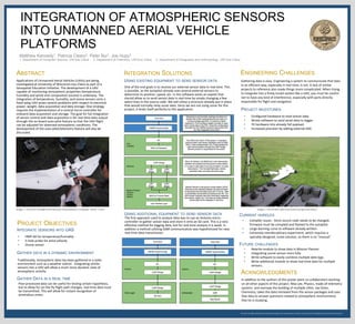
  • 1. We thank the Office of Research and Sponsored Programs for supporting this research, and Learning & Technology Services for printing this poster. INTEGRATION OF ATMOSPHERIC SENSORS INTO UNMANNED AERIAL VEHICLE PLATFORMS Matthew Kennedy1, Patricia Cleary2, Peter Bui1, Joe Hupy3 1. Department of Computer Science, UW-Eau Claire 2. Department of Chemistry, UW-Eau Claire 3. Department of Geography and Anthropology, UW-Eau Claire Applications of Unmanned Aerial Vehicles (UAVs) are being investigated at University of Wisconsin-Eau Claire as part of a Geospatial Education Initiative. The development of a UAV capable of monitoring atmospheric properties (temperature, humidity and wind) and composition (ozone) is underway. The integration of temperature, humidity, and ozone sensors onto a fixed wing UAV poses several problems with respect to electrical power, weight, data acquisition and data storage. One strategy requires the implementation of a central micro-controller for onboard data acquisition and storage. The goal for full integration of sensor control and data acquisition is for real-time data output through the on-board auto-pilot feature so that the UAV flight can be adjusted for observed atmospheric conditions. The development of the auto-pilot/telemetry feature will also be discussed. Image 1 - RV Jet on trial flight with Personal Ozone Monitor in payload. Result : Crash ABSTRACT USING ADDITIONAL EQUIPMENT TO SEND SENSOR DATA One of the end goals is to receive our external sensor data in real-time. This is possible, as the autopilot already uses several external sensors to determine its position, speed, etc. In the software exists an exploit that should allow us to send sensor data in real-time by simply changing a few select lines in the source code. We will utilize a structure already put in place that would normally relay sonar data. Since we are not using sonar for this project, it lends itself perfectly to this application. INTEGRATION SOLUTIONS • HMP-60 for temperature/humidity • 5-hole probe for wind velocity • Ozone sensor In addition to the authors of this poster were co-collaborators working on all other aspects of this project. Max Lee, Physics, made all telemetry systems and oversaw the building of multiple UAVs. Joe Oster, Chemistry, takes the data retrieved from the sensor packages and uses that data to answer questions related to atmospheric environments that he is studying. PROJECT OBJECTIVES Image 2 - RV Jet with radio transmitter and ground station ENGINEERING CHALLENGES USING EXISTING EQUIPMENT TO SEND SENSOR DATA The first approach used to analyze data was to use an Arduino micro- controller to gather sensor data and store it onto an SD card. This is a very effective method for logging data, but for real-time analysis it is weak. In addition a method utilizing GSM communication was hypothesized for near real-time data transmission. ACKNOWLEDGMENTS INTEGRATE SENSORS INTO UAS GATHER DATA IN A DYNAMIC ENVIRONMENT Traditionally, atmospheric data has been gathered in a static environment such as a weather station . Integrating similar sensors into a UAV will allow a much more dynamic view of atmospheric activity. GATHER DATA IN A REAL TIME Post-processed data can be useful for testing certain hypothesis, but to allow for on-the-fly flight path changes, real-time data must be transmitted. This will allow for instant recognition of anomalous zones. Gathering data is easy. Engineering a system to communicate that data in an efficient way, especially in real-time, is not. A lack of similar projects to reference also made things more complicated. When trying to integrate into a finely tuned system like a UAV, you must be careful not to have any kind of interference, especially with parts directly responsible for flight and navigation. FUTURE CHALLENGES • Configured hardware to read sensor data • Wrote software to send serial data to logger • Fit hardware into already full payload. • Increased precision by adding external ADC. • Rewrite module to show data in Mission Planner • Integrating ozone sensor more fully • Write software to easily combine multiple data logs. • Write additional module to show real-time data for multiple sensors. PROJECT MILESTONES CURRENT HURDLES • Compiler issues - Since source code needs to be changed, firmware must be compiled and flashed to the autopilot • Large learning curve to software already written. • Extremely interdisciplinary experiment, which requires a specially-designed, novel solution, so there is no “manual”