Landforms along rivers
•Als PPTX, PDF herunterladen•
3 gefällt mir•3,238 views

Landforms along rivers presentation - 6th grade science. River cutters unit

Empfohlen
Weitere ähnliche Inhalte
Was ist angesagt?
Was ist angesagt? (20)
Ähnlich wie Landforms along rivers
Ähnlich wie Landforms along rivers (20)
Mehr von Mariana Serrato
Mehr von Mariana Serrato (18)
Kürzlich hochgeladen
Kürzlich hochgeladen (20)
Landforms along rivers
- 2. Weathering and erosion • Weathering is the weakening, breaking up, rotting and disintegration of rocks. • Weathering is followed by erosion, which is a process of scraping, scratching and grinding of surface level rock. • All landforms are affected by the cycle of erosion.
- 3. Natural agents of weathering and erosion Water • Running water is a common cause of weathering. • As water flows past rock, it wears away tiny particles off the rock’s surface. • A stream that is moving quickly will cut deep into a rock. • Rain falling from the sky will cause weathering. • As water flows downhill, it weathers all of the surface it comes into contact with.
- 4. Natural agents of weathering and erosion Ice Water creeps into tiny cracks and dents in rock. If it freezes, the water will expand and take up more space as it changes into ice. When the water expands, it will cause cracks in the rocks. If the water thaws and freezes again, it will make even more cracks. Cracks in rocks will break rock down into smaller pieces over time.
- 5. Natural agents of weathering and erosion Wind • Wind carries small particles of sand and soil. As these particles blow over rocky surfaces, they scrape them. Abrasion is the grinding away of rock by other rock and sand particles. Wind causes abrasion. • Water also causes abrasion when it carries sand and rocks that scrape against other rock.
- 6. Natural agents of weathering and erosion Gravity • Gravity is the force that pulls things toward Earth. Water flows downhill because that is always the direction that gravity pulls it. Together with gravity, water, wind and ice have worked to form all the landforms you can see around you.
- 7. Degradation and deposition • The result of weathering, erosion and transportation is known as degradation. • Deposition means filling up of depressions on the Earth’s surface. • Each agent of erosion has it’s own degradational and depositional role in changing the landscape slowly, but surely.
- 8. Landforms caused by rivers – Headwaters • It starts with a drip. Probably from melting snow high in the mountains during the warming of spring. The drips collect together until they form a small puddle. This puddle begins to run down the slope of a mountain in a very small trickle. This is the start of a river. • Although very small, this is where it all begins. This is called the headwaters or the source. It doesn’t start in one specific place, but in many locations generally around the highest part of a mountain.
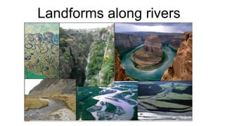
- 9. Landforms caused by rivers - Valleys • A V-shaped valley, sometimes called a river valley, is a narrow valley with steeply sloped sides that appear similar to the letter "V" from a cross-section. They are formed by strong streams, which over time have cut down into the rock through a process called downcutting. These valleys form in mountainous and/or highland areas with streams in their "youthful" stage. At this stage, streams flow rapidly down steep slopes.
- 10. Landforms caused by rivers - Canyons • As a river travels and carries away rocks and soil, it can create a deep groove in the earth’s surface. All along the sides of the river, the groove can get deeper and deeper. In time, this can create a canyon. Depending upon the type of rock along the sides of the river, a canyon can have sharp cliff-like sides. Some canyons are very famous, such as the Grand Canyon or the Snake River Canyon.
- 11. Landforms caused by rivers - Rapids • River rapids are formed when flowing water comes across soft and hard rocks of differing heights. The water has to alter its flow to bend round the rocks, and when it does, it joins with the water flowing through the rocks. The extra pressure of the water joining together is what causes the rapids.
- 12. Landforms caused by rivers - Waterfalls • Water falls over hard rock. When it reaches the soft rock, the water starts to wear away the soft rock. Over hundreds or even thousands of years, the soft rock is slowly eaten away or eroded and the river begins to cut down further into the soft rock. This makes a cliff over which the water can topple. Over time, the cliff becomes steeper as more soft rock is eroded, and deeper as bigger boulders come over the waterfall, and the ground gets beaten with more and more rocks until it creates a plunge pool.
- 13. Landforms caused by rivers - Gorges
- 14. Landforms caused by rivers - Meanders • A meander is a bend in the river. Meanders are caused by the erosion of river banks. The sediment or earth on the outside of the bend of moving water, and is then deposited on the inside, which builds the meander.
- 15. Landforms caused by rivers – Oxbow lake
- 16. Landforms caused by rivers – Floodplains • The amount of water being transported in a particular stream at any given time varies with weather conditions. Sometimes, more water pours into a stream than the banks of the stream channel can hold, causing a flood along the river banks. The board, flat area that extends out from a stream's bank and is covered by excess water during times of flooding is know as the stream's floodplain.
- 17. Landforms caused by rivers – Levees A natural levee is formed by a deposit of sand or mud built up along, and sloping away from, either side of the flood plain of a river or stream. This in done by the action of the water itself. The process occurs slowly over a number of years.
- 18. Landforms caused by rivers – river mouth • A river mouth or stream mouth is a part of a river where it flows into the sea, river, lake, reservoir or ocean. At the mouth of a river a delta is formed resulting from sediment deposition.
- 19. Landforms caused by rivers – river mouth • A river delta is a landform that is formed at the mouth of a river, where the river flows into an ocean, sea, estuary, lake, or reservoir. Deltas are formed from the deposition of the sediment carried by the river as the flow leaves the mouth of the river. Over long periods of time, this deposition builds the characteristic geographic pattern of a river delta.