USGS Assessment for Size of Marcellus Shale
•
1 gefällt mir•452 views

Published in August 2011, the USGS report titled, "Assessment of Undiscovered Oil and Gas Resources of the Devonian Marcellus Shale of the Appalachian Basin Province, 2011" which looks at how much recoverable natural gas is available in the Marcellus Shale. The USGS estimates the Marcellus to be the largest shale field (by reserves) in the United States.
![Together, these components confirm the Marcellus Shale as The Marcellus Shale is divided into three AUs within
a continuous petroleum accumulation. Using this geologic the formation’s extent in the Appalachian Basin—the
framework, the USGS defined one TPS and three assessment Western Margin Marcellus AU, which encompasses the
units (AUs) within this TPS and quantitatively estimated the western extent of the formation and west of the Appalachian
undiscovered oil and gas resources within the three AUs (table Structural Front (ASF); the Interior Marcellus AU, which is
1). For the purposes of this assessment, the Marcellus Shale is the central extent of the trend and west of the ASF; and the
considered to be that Middle Devonian interval that consists Foldbelt Marcellus AU,which is east of the ASF. The total
primarily of shale and lesser amounts of bentonite, limestone, area of these three AUs extends from southern New York
and siltstone occurring between the underlying Middle to northeastern Tennessee and from central Ohio to western
Devonian Onondaga Limestone (or its stratigraphic equivalents, Virginia and Maryland.
the Needmore Shale and Huntersville Chert) and the overlying The Western Margin Marcellus AU includes the formation
Middle Devonian Mahantango Formation (or its stratigraphic where it is less than 50 feet (ft) thick, ranges in depth from
equivalents, the upper Millboro Shale and middle Hamilton less than 2,000 ft to more than 9,000 ft, and contains strata
Group). that range in current levels of thermal maturity from pre-peak
oil to past-peak gas. The Interior Marcellus AU contains the
Resource Summary Marcellus Shale that is 50 feet thick or more, ranges in depth
from less than 2,000 ft to more than 11,000 ft, and contains
The USGS assessed the technically recoverable, strata that range in current levels of thermal maturity from
undiscovered continuous (unconventional) gas within the peak oil to past-peak gas. The Foldbelt Marcellus AU contains
Marcellus Shale and estimated a mean of 84,198 billion cubic the Marcellus Shale within the Appalachian fold and thrust
feet of gas and a mean of 3,379 million barrels of total natural belt, ranges in thickness from a few feet to more than 350 ft
gas liquids. The entire undiscovered gas and natural gas liquids thick, ranges in depth from outcrop to more than 11,000 ft, and
resource is in a continuous accumulation and is contained contains strata that range in current levels of thermal maturity
within a single TPS, the Devonian Shale-Middle and Upper from peak gas to past-peak gas.
Paleozoic TPS (table 1). Ninety-six percent of the estimated
resource resides within the Interior Marcellus AU.
Table 1. Appalachian Basin Province assessment results.
[Results shown are fully risked estimates. For gas accumulations, all liquids are included as natural gas liquids (NGL). F95 represents a 95 percent chance of at least the
amount tabulated; other fractiles are defined similarly. Fractiles are additive under the assumption of perfect positive correlation. AU, assessment unit, BCFG, billion
cubic feet of gas. MMBNGL, million barrels of natural gas liquids; TPS, total petroleum system]
Total undiscovered resources
Total Petroleum System (TPS) Field
AU probability Gas (BCFG) NGL (MMBNGL)
and Assessment Units (AU) type
F95 F50 F5 Mean F95 F50 F5 Mean
Devonian Shale-Middle and Upper Paleozoic TPS
Foldbelt Marcellus AU Gas 1.0 345 698 1,410 765 0 0 0 0
Interior Marcellus AU Gas 1.0 41,607 76,078 139,106 81,374 1,497 2,982 5,938 3,255
Western Margin Marcellus AU Gas 1.0 1,002 1,907 3,629 2,059 57 113 224 124
Total undiscovered resources 42,954 78,683 144,145 84,198 1,554 3,095 6,162 3,379
Marcellus Shale Assessment Team For Further Information
James L. Coleman (task leader, jlcoleman@usgs.gov), Supporting geologic reports on the Marcellus Shale
Robert C. Milici, Troy A. Cook, Ronald R. Charpentier, Mark resource assessment are in preparation. More information about
Kirschbaum, Timothy R. Klett, Richard M. Pollastro, and the Marcellus Shale and other oil and gas assessments, the
Christopher J. Schenk assessment methodology, and the TPS and assessment units
can be found at the USGS Energy Resources Program Web site
(http://energy.usgs.gov/).](data:image/gif;base64,R0lGODlhAQABAIAAAAAAAP///yH5BAEAAAAALAAAAAABAAEAAAIBRAA7)
Empfohlen
Empfohlen
Weitere ähnliche Inhalte
Mehr von Marcellus Drilling News
Mehr von Marcellus Drilling News (20)
Kürzlich hochgeladen
Kürzlich hochgeladen (20)
USGS Assessment for Size of Marcellus Shale
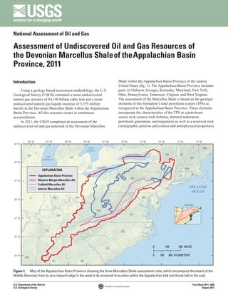
- 1. National Assessment of Oil and Gas Assessment of Undiscovered Oil and Gas Resources of the Devonian Marcellus Shale of the Appalachian Basin Province, 2011 Introduction Shale within the Appalachian Basin Province of the eastern United States (fig. 1). The Appalachian Basin Province includes Using a geology-based assessment methodology, the U.S. parts of Alabama, Georgia, Kentucky, Maryland, New York, Geological Survey (USGS) estimated a mean undiscovered Ohio, Pennsylvania, Tennessee, Virginia, and West Virginia. natural gas resource of 84,198 billion cubic feet and a mean The assessment of the Marcellus Shale is based on the geologic undiscovered natural gas liquids resource of 3,379 million elements of this formation’s total petroleum system (TPS) as barrels in the Devonian Marcellus Shale within the Appalachian recognized in the Appalachian Basin Province. These elements Basin Province. All this resource occurs in continuous incorporate the characteristics of the TPS as a petroleum accumulations. source rock (source rock richness, thermal maturation, In 2011, the USGS completed an assessment of the petroleum generation, and migration) as well as a reservoir rock undiscovered oil and gas potential of the Devonian Marcellus (stratigraphic position and content and petrophysical properties). 89° W 87° W 85° W 83° W 81° W 79° W 77° W 75° W 73° W 71° W 45° N LAKE ME HURON WI LAKE ONTARIO NY VT LAKE MI NH MICHIGAN 43° N LAKE ERIE EXPLANATION MA Appalachian Basin Province CT RI PA 41° N Western Margin Marcellus AU Foldbelt Marcellus AU Interior Marcellus AU NJ ATLANTIC OCEAN IL IN OH MD 39° N DE Area map WV KY VA 37° N TN NC 35° N SC 0 100 200 MILES 33° N 0 100 200 KILOMETERS MS AL GA Figure 1. Map of the Appalachian Basin Province showing the three Marcellus Shale assessment units, which encompass the extent of the Middle Devonian from its zero isopach edge in the west to its erosional truncation within the Appalachian fold and thrust belt in the east. U.S. Department of the Interior Fact Sheet 2011–3092 Printed on recycled paper U.S. Geological Survey August 2011
- 2. Together, these components confirm the Marcellus Shale as The Marcellus Shale is divided into three AUs within a continuous petroleum accumulation. Using this geologic the formation’s extent in the Appalachian Basin—the framework, the USGS defined one TPS and three assessment Western Margin Marcellus AU, which encompasses the units (AUs) within this TPS and quantitatively estimated the western extent of the formation and west of the Appalachian undiscovered oil and gas resources within the three AUs (table Structural Front (ASF); the Interior Marcellus AU, which is 1). For the purposes of this assessment, the Marcellus Shale is the central extent of the trend and west of the ASF; and the considered to be that Middle Devonian interval that consists Foldbelt Marcellus AU,which is east of the ASF. The total primarily of shale and lesser amounts of bentonite, limestone, area of these three AUs extends from southern New York and siltstone occurring between the underlying Middle to northeastern Tennessee and from central Ohio to western Devonian Onondaga Limestone (or its stratigraphic equivalents, Virginia and Maryland. the Needmore Shale and Huntersville Chert) and the overlying The Western Margin Marcellus AU includes the formation Middle Devonian Mahantango Formation (or its stratigraphic where it is less than 50 feet (ft) thick, ranges in depth from equivalents, the upper Millboro Shale and middle Hamilton less than 2,000 ft to more than 9,000 ft, and contains strata Group). that range in current levels of thermal maturity from pre-peak oil to past-peak gas. The Interior Marcellus AU contains the Resource Summary Marcellus Shale that is 50 feet thick or more, ranges in depth from less than 2,000 ft to more than 11,000 ft, and contains The USGS assessed the technically recoverable, strata that range in current levels of thermal maturity from undiscovered continuous (unconventional) gas within the peak oil to past-peak gas. The Foldbelt Marcellus AU contains Marcellus Shale and estimated a mean of 84,198 billion cubic the Marcellus Shale within the Appalachian fold and thrust feet of gas and a mean of 3,379 million barrels of total natural belt, ranges in thickness from a few feet to more than 350 ft gas liquids. The entire undiscovered gas and natural gas liquids thick, ranges in depth from outcrop to more than 11,000 ft, and resource is in a continuous accumulation and is contained contains strata that range in current levels of thermal maturity within a single TPS, the Devonian Shale-Middle and Upper from peak gas to past-peak gas. Paleozoic TPS (table 1). Ninety-six percent of the estimated resource resides within the Interior Marcellus AU. Table 1. Appalachian Basin Province assessment results. [Results shown are fully risked estimates. For gas accumulations, all liquids are included as natural gas liquids (NGL). F95 represents a 95 percent chance of at least the amount tabulated; other fractiles are defined similarly. Fractiles are additive under the assumption of perfect positive correlation. AU, assessment unit, BCFG, billion cubic feet of gas. MMBNGL, million barrels of natural gas liquids; TPS, total petroleum system] Total undiscovered resources Total Petroleum System (TPS) Field AU probability Gas (BCFG) NGL (MMBNGL) and Assessment Units (AU) type F95 F50 F5 Mean F95 F50 F5 Mean Devonian Shale-Middle and Upper Paleozoic TPS Foldbelt Marcellus AU Gas 1.0 345 698 1,410 765 0 0 0 0 Interior Marcellus AU Gas 1.0 41,607 76,078 139,106 81,374 1,497 2,982 5,938 3,255 Western Margin Marcellus AU Gas 1.0 1,002 1,907 3,629 2,059 57 113 224 124 Total undiscovered resources 42,954 78,683 144,145 84,198 1,554 3,095 6,162 3,379 Marcellus Shale Assessment Team For Further Information James L. Coleman (task leader, jlcoleman@usgs.gov), Supporting geologic reports on the Marcellus Shale Robert C. Milici, Troy A. Cook, Ronald R. Charpentier, Mark resource assessment are in preparation. More information about Kirschbaum, Timothy R. Klett, Richard M. Pollastro, and the Marcellus Shale and other oil and gas assessments, the Christopher J. Schenk assessment methodology, and the TPS and assessment units can be found at the USGS Energy Resources Program Web site (http://energy.usgs.gov/).