
Empfohlen
Weitere ähnliche Inhalte
Was ist angesagt?
Was ist angesagt? (20)
Ähnlich wie Machu Picchu
Ähnlich wie Machu Picchu (20)
Kürzlich hochgeladen
Kürzlich hochgeladen (20)
Machu Picchu
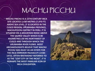
- 1. MACHU PICCHU MACHU PIKCHU IS A 15TH-CENTURY INCA SITE LOCATED 2,430 METRES (7,970 FT) ABOVE SEA LEVEL. IT IS LOCATED IN THE CUSCO REGION, URUBAMBA PROVINCE, MACHUPICCHU DISTRICT IN PERU. IT IS SITUATED ON A MOUNTAIN RIDGE ABOVE THE SACRED VALLEY WHICH IS 80 KILOMETRES (50 MI) NORTHWEST OF CUSCO AND THROUGH WHICH THE URUBAMBA RIVER FLOWS. MOST ARCHAEOLOGISTS BELIEVE THAT MACHU PICCHU WAS BUILT AS AN ESTATE FOR THE INCA EMPEROR PACHACUTI (1438– 1472). OFTEN MISTAKENLY REFERRED TO AS THE "LOST CITY OF THE INCAS", IT IS PERHAPS THE MOST FAMILIAR ICON OF INCA CIVILIZATION.
- 2. CLIMATE It's tropical, warm and sunny days and cool nights. It's very rainy between December and March, but it's still wonderful. Bring a rain-jacket or umbrella, and you will be fine.
- 3. LANDSCAPES Machu Picchu is 1,000 meters (3,300 ft.) lower than Cusco city, that's why the environment here is different. The cloud-forest that covers the steep mountains around the citadel is habitat of an interesting wildlife that includes the Andean bear and the cock-of the rock bird. The ruins and the surroundings are part of a national park to protect the archaeological remains and the environment.
- 4. GEOGRAPHY Machu Picchu lies in the southern hemisphere, 13.164 degrees south of the equator.It is 80 kilometres (50 miles) northwest of Cusco, on the crest of the mountain Machu Picchu, located about 2,430 metres (7,970 feet) above mean sea level, over 1,000 metres (3,300 ft) lower than Cusco, which has an elevation of 3,600 metres (11,800 ft). As such, it had a milder climate than the Inca capital. It is one of the most important archaeological sites in South America, one of the most visited tourist attractions in all of Latin America and the most visited tourist attraction in Peru.
- 5. CONSTRUCTION The central buildings of Machu Picchu use the classical Inca architectural style of polished dry-stone walls of regular shape. The Incas were masters of this technique, called ashlar, in which blocks of stone are cut to fit together tightly without mortar. Many junctions in the central city are so perfect that it is said not even a blade of grass fits between the stones.
- 6. THREATS The 'Santa Teresa II' hydropower project proposes diverting 105 cubic metres (3,700 cubic feet) of water from the Vilcanota river through a 14 km (9 mi) tunnel that will run underneath organic coffee and fruit plantations.This process will drain the plantations above the tunnel and disrupt the warm water flows to the famous thermal baths in Cocalmayo as the tunnel runs through the two folds that feeds the waters to the thermal baths.