SlideShare ist ein Scribd-Unternehmen logo
1 von 1
Downloaden Sie, um offline zu lesen
Integrating Data from NASA Missions into NOAA's
Pacific Region Integrated Climatology Information Products (PRICIP)
PROJECT GOALS
- Integrate weather data acquired by NASA missions into
tropical storm event geovisualizations
(i.e. animations that correlate to a ground reference)
- Animate annual tropical storm tracks for
1992, 2002, 2004, 2005
- Animate anomalous high water events near Hawaii
- Develop an easy-to-use interface to accommodate multiple
data layers for each storm event
AREA OF INTEREST
All storm events animated for the PRICIP Project occurred
within the Pacific Ocean basin, at times incorporating
localized views for the Cook and Hawaiian Islands.
SIGNIFICANCE
Contribute geovisualizations to NOAA’s ongoing PRICIP
project, an interactive decision support tool intended to
reduce coastal vulnerability.
VALUE & BENEFITS
• Illustrate ability of NASA mission data products to highlight
severe oceanic storm variables
• Supply geovisualizations for NOAA’s PRICIP Web Portal
• Provide easily downloaded data for future research
• Improve the decision support tools used by decision makers
PRODUCTS
Interactive Geovisualizations &
Animated Annual Storm Tracks...
METHODOLOGY
GEOVISUALIZATION
PRODUCTS
• Sea Surface Wind Direction
• Sea Surface Wind Speed
• Precipitation Accumulation
• Sea Surface Temperature
• Mean Sea Level Anomaly
• Composite: Wind Speed &
Precipitation Accumulation
• Animated Annual Storm
Tracks
NASA MISSION
SELECTION
QuikSCAT (SeaWinds)
TRMM (TMI)
Jason-1 & TOPEX/POSEIDON
Aqua (AMSR-E)
STORM EVENTS
• Super Typhoon
Pongsona
• Cyclone Heta
• Typhoon Chata’an
• Hurricane Iniki
• “Cook Islands Five”
• High Water Events
STORM
VARIABLES
• Strong Winds
• Heavy Rains
• High Seas
• Sea Temperatures
DATA DELIVERABLES
Downloadable Data GIS
Ready
SATELLITE
DATA
GIS
Processing
FINAL GIS
IMAGE
FINAL GIS
DATA
PARTNER
Science Adviser: John Marra, PhD, - NOAA IDEA Center DEVELOP PRICIP team at NASA JPL
Lisa Benham - San Jose State University
W. Kyle Chester - University of Minnesota, Twin Cities
Art Eisberg - University of California, Santa Barbara
Krista Lee - University of California, Santa Barbara
Supriya Iyer - Leland High School, San Jose
Team:
Cindy Schmidt - San Jose State University
J.W. Skiles, PhD - NASA Ames Research Center
Mentors:

Weitere ähnliche Inhalte

Was ist angesagt?

The Pan-Arctic Impacts of Thinning Sea Ice
The Pan-Arctic Impacts of Thinning Sea IceThe Pan-Arctic Impacts of Thinning Sea Ice
The Pan-Arctic Impacts of Thinning Sea IceZachary Labe
 
Using data visualization for effective science (communication)
Using data visualization for effective science (communication)Using data visualization for effective science (communication)
Using data visualization for effective science (communication)Zachary Labe
 
Dissertation Defense: Zachary Labe
Dissertation Defense: Zachary LabeDissertation Defense: Zachary Labe
Dissertation Defense: Zachary LabeZachary Labe
 
Building a Sustainable Infrastructure at NASA
Building a Sustainable Infrastructure at NASABuilding a Sustainable Infrastructure at NASA
Building a Sustainable Infrastructure at NASAJenna Riemenschneider
 
Making Effective Figures
Making Effective FiguresMaking Effective Figures
Making Effective FiguresZachary Labe
 
Record Setting: The Origins of Extreme Hail on 19 March 2018 during VORTEX-SE
Record Setting: The Origins of Extreme Hail on 19 March 2018 during VORTEX-SERecord Setting: The Origins of Extreme Hail on 19 March 2018 during VORTEX-SE
Record Setting: The Origins of Extreme Hail on 19 March 2018 during VORTEX-SEDeanMeyer14
 
Integrating Climate Data Into Forecasting Hydrologic Inflow - Laura Blaylock ...
Integrating Climate Data Into Forecasting Hydrologic Inflow - Laura Blaylock ...Integrating Climate Data Into Forecasting Hydrologic Inflow - Laura Blaylock ...
Integrating Climate Data Into Forecasting Hydrologic Inflow - Laura Blaylock ...TWCA
 
3.3 Climate data and projections
3.3 Climate data and projections3.3 Climate data and projections
3.3 Climate data and projectionsNAP Events
 
Refining projections of the 'warm Arctic, cold Siberia' pattern in climate mo...
Refining projections of the 'warm Arctic, cold Siberia' pattern in climate mo...Refining projections of the 'warm Arctic, cold Siberia' pattern in climate mo...
Refining projections of the 'warm Arctic, cold Siberia' pattern in climate mo...Zachary Labe
 
2018 Machine Learning and Physical Sciences Symposium
2018 Machine Learning and Physical Sciences Symposium 2018 Machine Learning and Physical Sciences Symposium
2018 Machine Learning and Physical Sciences Symposium Zachary Labe
 
Vertical GPS Response to Snow and Ice Mass Changes
Vertical GPS Response to Snow and Ice Mass ChangesVertical GPS Response to Snow and Ice Mass Changes
Vertical GPS Response to Snow and Ice Mass ChangesSERC at Carleton College
 
C3.01: The Global Ocean Forecasting Initiative GODAE OceanView - Andreas Schi...
C3.01: The Global Ocean Forecasting Initiative GODAE OceanView - Andreas Schi...C3.01: The Global Ocean Forecasting Initiative GODAE OceanView - Andreas Schi...
C3.01: The Global Ocean Forecasting Initiative GODAE OceanView - Andreas Schi...Blue Planet Symposium
 
Stephan harrison
Stephan harrisonStephan harrison
Stephan harrisonClimDev15
 
Trends and regional variability of observed Arctic sea-ice thickness
Trends and regional variability of observed Arctic sea-ice thicknessTrends and regional variability of observed Arctic sea-ice thickness
Trends and regional variability of observed Arctic sea-ice thicknessZachary Labe
 
Modeling the Climate System: Is model-based science like model-based engineer...
Modeling the Climate System: Is model-based science like model-based engineer...Modeling the Climate System: Is model-based science like model-based engineer...
Modeling the Climate System: Is model-based science like model-based engineer...Steve Easterbrook
 
Lesson 7 Basis for projection of climate change
Lesson 7   Basis for projection of climate changeLesson 7   Basis for projection of climate change
Lesson 7 Basis for projection of climate changeDr. P.B.Dharmasena
 

Was ist angesagt? (20)

The Pan-Arctic Impacts of Thinning Sea Ice
The Pan-Arctic Impacts of Thinning Sea IceThe Pan-Arctic Impacts of Thinning Sea Ice
The Pan-Arctic Impacts of Thinning Sea Ice
 
Using data visualization for effective science (communication)
Using data visualization for effective science (communication)Using data visualization for effective science (communication)
Using data visualization for effective science (communication)
 
Dissertation Defense: Zachary Labe
Dissertation Defense: Zachary LabeDissertation Defense: Zachary Labe
Dissertation Defense: Zachary Labe
 
Building a Sustainable Infrastructure at NASA
Building a Sustainable Infrastructure at NASABuilding a Sustainable Infrastructure at NASA
Building a Sustainable Infrastructure at NASA
 
Making Effective Figures
Making Effective FiguresMaking Effective Figures
Making Effective Figures
 
Record Setting: The Origins of Extreme Hail on 19 March 2018 during VORTEX-SE
Record Setting: The Origins of Extreme Hail on 19 March 2018 during VORTEX-SERecord Setting: The Origins of Extreme Hail on 19 March 2018 during VORTEX-SE
Record Setting: The Origins of Extreme Hail on 19 March 2018 during VORTEX-SE
 
Integrating Climate Data Into Forecasting Hydrologic Inflow - Laura Blaylock ...
Integrating Climate Data Into Forecasting Hydrologic Inflow - Laura Blaylock ...Integrating Climate Data Into Forecasting Hydrologic Inflow - Laura Blaylock ...
Integrating Climate Data Into Forecasting Hydrologic Inflow - Laura Blaylock ...
 
3.3 Climate data and projections
3.3 Climate data and projections3.3 Climate data and projections
3.3 Climate data and projections
 
C1 Freysteinn Sigmundsson
C1 Freysteinn SigmundssonC1 Freysteinn Sigmundsson
C1 Freysteinn Sigmundsson
 
Refining projections of the 'warm Arctic, cold Siberia' pattern in climate mo...
Refining projections of the 'warm Arctic, cold Siberia' pattern in climate mo...Refining projections of the 'warm Arctic, cold Siberia' pattern in climate mo...
Refining projections of the 'warm Arctic, cold Siberia' pattern in climate mo...
 
Godo sec season
Godo sec seasonGodo sec season
Godo sec season
 
2018 Machine Learning and Physical Sciences Symposium
2018 Machine Learning and Physical Sciences Symposium 2018 Machine Learning and Physical Sciences Symposium
2018 Machine Learning and Physical Sciences Symposium
 
Vertical GPS Response to Snow and Ice Mass Changes
Vertical GPS Response to Snow and Ice Mass ChangesVertical GPS Response to Snow and Ice Mass Changes
Vertical GPS Response to Snow and Ice Mass Changes
 
C3.01: The Global Ocean Forecasting Initiative GODAE OceanView - Andreas Schi...
C3.01: The Global Ocean Forecasting Initiative GODAE OceanView - Andreas Schi...C3.01: The Global Ocean Forecasting Initiative GODAE OceanView - Andreas Schi...
C3.01: The Global Ocean Forecasting Initiative GODAE OceanView - Andreas Schi...
 
Stephan harrison
Stephan harrisonStephan harrison
Stephan harrison
 
Trends and regional variability of observed Arctic sea-ice thickness
Trends and regional variability of observed Arctic sea-ice thicknessTrends and regional variability of observed Arctic sea-ice thickness
Trends and regional variability of observed Arctic sea-ice thickness
 
Unit 4: figures
Unit 4: figuresUnit 4: figures
Unit 4: figures
 
GIS as a Land Planning Resource
GIS as a Land Planning ResourceGIS as a Land Planning Resource
GIS as a Land Planning Resource
 
Modeling the Climate System: Is model-based science like model-based engineer...
Modeling the Climate System: Is model-based science like model-based engineer...Modeling the Climate System: Is model-based science like model-based engineer...
Modeling the Climate System: Is model-based science like model-based engineer...
 
Lesson 7 Basis for projection of climate change
Lesson 7   Basis for projection of climate changeLesson 7   Basis for projection of climate change
Lesson 7 Basis for projection of climate change
 

Ähnlich wie PRICIP_poster_2008_Dec

Research + Private Sector Partnerships - Climate information for social and e...
Research + Private Sector Partnerships - Climate information for social and e...Research + Private Sector Partnerships - Climate information for social and e...
Research + Private Sector Partnerships - Climate information for social and e...UCAR - Atmospheric & Earth System Science
 
Ocean Globe, Ocean Geospatial Appliance
Ocean Globe, Ocean Geospatial ApplianceOcean Globe, Ocean Geospatial Appliance
Ocean Globe, Ocean Geospatial ApplianceHigh Tech Maui
 
Sea level rise and storm surge tools and datasets supporting Municipal Resili...
Sea level rise and storm surge tools and datasets supporting Municipal Resili...Sea level rise and storm surge tools and datasets supporting Municipal Resili...
Sea level rise and storm surge tools and datasets supporting Municipal Resili...GrowSmart Maine
 
Adopt a drifter presentation
Adopt a drifter presentationAdopt a drifter presentation
Adopt a drifter presentationNataliya_Byzova
 
Hurricane harvey copy
Hurricane harvey   copyHurricane harvey   copy
Hurricane harvey copyAndrew Zolnai
 
Summer seminar hurricanes - 27. july 2012
Summer seminar   hurricanes - 27. july 2012Summer seminar   hurricanes - 27. july 2012
Summer seminar hurricanes - 27. july 2012EUintheUS
 
TU2.L10 - THE AQUARIUS/SAC-D MISSION OVERVIEW
TU2.L10 - THE AQUARIUS/SAC-D MISSION OVERVIEWTU2.L10 - THE AQUARIUS/SAC-D MISSION OVERVIEW
TU2.L10 - THE AQUARIUS/SAC-D MISSION OVERVIEWgrssieee
 
Noaa climate service_shea
Noaa climate service_sheaNoaa climate service_shea
Noaa climate service_sheaRebreid
 
Esip noaa climate_shea
Esip noaa climate_sheaEsip noaa climate_shea
Esip noaa climate_sheaRebreid
 
ForeC-Nepal Online Early Warning Systems
ForeC-Nepal Online Early Warning SystemsForeC-Nepal Online Early Warning Systems
ForeC-Nepal Online Early Warning SystemsBrian Eyler
 
Summer seminar on "Hurricanes and Coastal Hazards"
Summer seminar on "Hurricanes and Coastal Hazards"Summer seminar on "Hurricanes and Coastal Hazards"
Summer seminar on "Hurricanes and Coastal Hazards"EUintheUS
 
Summer seminar on "Hurricanes and Coastal Hazards: - 27. july 2012
Summer seminar on "Hurricanes and Coastal Hazards: - 27. july 2012Summer seminar on "Hurricanes and Coastal Hazards: - 27. july 2012
Summer seminar on "Hurricanes and Coastal Hazards: - 27. july 2012EUintheUS
 
Mike Simon Cuevas Resume
Mike Simon Cuevas ResumeMike Simon Cuevas Resume
Mike Simon Cuevas Resumezumas191
 
Webinar presentation ocean modelling and early-warning system for the gulf ...
Webinar presentation   ocean modelling and early-warning system for the gulf ...Webinar presentation   ocean modelling and early-warning system for the gulf ...
Webinar presentation ocean modelling and early-warning system for the gulf ...Deltares
 
DSD-INT 2018 An Engineering Approach to construction of a Storm Surge Model f...
DSD-INT 2018 An Engineering Approach to construction of a Storm Surge Model f...DSD-INT 2018 An Engineering Approach to construction of a Storm Surge Model f...
DSD-INT 2018 An Engineering Approach to construction of a Storm Surge Model f...Deltares
 
AGU2012_SSC_LA_Eco_Poster_RRR-BB (Develop)
AGU2012_SSC_LA_Eco_Poster_RRR-BB (Develop)AGU2012_SSC_LA_Eco_Poster_RRR-BB (Develop)
AGU2012_SSC_LA_Eco_Poster_RRR-BB (Develop)Blaise Pezold
 
The NASA Western Water Applications Office - Indrani C. Graczyk
The NASA Western Water Applications Office - Indrani C. GraczykThe NASA Western Water Applications Office - Indrani C. Graczyk
The NASA Western Water Applications Office - Indrani C. GraczykTWCA
 
An Introduction to the Environment Agency extreme offshore wave, water level ...
An Introduction to the Environment Agency extreme offshore wave, water level ...An Introduction to the Environment Agency extreme offshore wave, water level ...
An Introduction to the Environment Agency extreme offshore wave, water level ...Stephen Flood
 

Ähnlich wie PRICIP_poster_2008_Dec (20)

Hawaii Pacific GIS Conference 2012: Plenary Session Keynote - Positioning the...
Hawaii Pacific GIS Conference 2012: Plenary Session Keynote - Positioning the...Hawaii Pacific GIS Conference 2012: Plenary Session Keynote - Positioning the...
Hawaii Pacific GIS Conference 2012: Plenary Session Keynote - Positioning the...
 
NOAA Data Products
NOAA Data ProductsNOAA Data Products
NOAA Data Products
 
Research + Private Sector Partnerships - Climate information for social and e...
Research + Private Sector Partnerships - Climate information for social and e...Research + Private Sector Partnerships - Climate information for social and e...
Research + Private Sector Partnerships - Climate information for social and e...
 
Ocean Globe, Ocean Geospatial Appliance
Ocean Globe, Ocean Geospatial ApplianceOcean Globe, Ocean Geospatial Appliance
Ocean Globe, Ocean Geospatial Appliance
 
Sea level rise and storm surge tools and datasets supporting Municipal Resili...
Sea level rise and storm surge tools and datasets supporting Municipal Resili...Sea level rise and storm surge tools and datasets supporting Municipal Resili...
Sea level rise and storm surge tools and datasets supporting Municipal Resili...
 
Adopt a drifter presentation
Adopt a drifter presentationAdopt a drifter presentation
Adopt a drifter presentation
 
Hurricane harvey copy
Hurricane harvey   copyHurricane harvey   copy
Hurricane harvey copy
 
Summer seminar hurricanes - 27. july 2012
Summer seminar   hurricanes - 27. july 2012Summer seminar   hurricanes - 27. july 2012
Summer seminar hurricanes - 27. july 2012
 
TU2.L10 - THE AQUARIUS/SAC-D MISSION OVERVIEW
TU2.L10 - THE AQUARIUS/SAC-D MISSION OVERVIEWTU2.L10 - THE AQUARIUS/SAC-D MISSION OVERVIEW
TU2.L10 - THE AQUARIUS/SAC-D MISSION OVERVIEW
 
Noaa climate service_shea
Noaa climate service_sheaNoaa climate service_shea
Noaa climate service_shea
 
Esip noaa climate_shea
Esip noaa climate_sheaEsip noaa climate_shea
Esip noaa climate_shea
 
ForeC-Nepal Online Early Warning Systems
ForeC-Nepal Online Early Warning SystemsForeC-Nepal Online Early Warning Systems
ForeC-Nepal Online Early Warning Systems
 
Summer seminar on "Hurricanes and Coastal Hazards"
Summer seminar on "Hurricanes and Coastal Hazards"Summer seminar on "Hurricanes and Coastal Hazards"
Summer seminar on "Hurricanes and Coastal Hazards"
 
Summer seminar on "Hurricanes and Coastal Hazards: - 27. july 2012
Summer seminar on "Hurricanes and Coastal Hazards: - 27. july 2012Summer seminar on "Hurricanes and Coastal Hazards: - 27. july 2012
Summer seminar on "Hurricanes and Coastal Hazards: - 27. july 2012
 
Mike Simon Cuevas Resume
Mike Simon Cuevas ResumeMike Simon Cuevas Resume
Mike Simon Cuevas Resume
 
Webinar presentation ocean modelling and early-warning system for the gulf ...
Webinar presentation   ocean modelling and early-warning system for the gulf ...Webinar presentation   ocean modelling and early-warning system for the gulf ...
Webinar presentation ocean modelling and early-warning system for the gulf ...
 
DSD-INT 2018 An Engineering Approach to construction of a Storm Surge Model f...
DSD-INT 2018 An Engineering Approach to construction of a Storm Surge Model f...DSD-INT 2018 An Engineering Approach to construction of a Storm Surge Model f...
DSD-INT 2018 An Engineering Approach to construction of a Storm Surge Model f...
 
AGU2012_SSC_LA_Eco_Poster_RRR-BB (Develop)
AGU2012_SSC_LA_Eco_Poster_RRR-BB (Develop)AGU2012_SSC_LA_Eco_Poster_RRR-BB (Develop)
AGU2012_SSC_LA_Eco_Poster_RRR-BB (Develop)
 
The NASA Western Water Applications Office - Indrani C. Graczyk
The NASA Western Water Applications Office - Indrani C. GraczykThe NASA Western Water Applications Office - Indrani C. Graczyk
The NASA Western Water Applications Office - Indrani C. Graczyk
 
An Introduction to the Environment Agency extreme offshore wave, water level ...
An Introduction to the Environment Agency extreme offshore wave, water level ...An Introduction to the Environment Agency extreme offshore wave, water level ...
An Introduction to the Environment Agency extreme offshore wave, water level ...
 

PRICIP_poster_2008_Dec

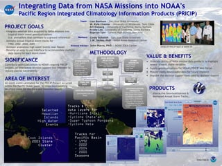
  • 1. Integrating Data from NASA Missions into NOAA's Pacific Region Integrated Climatology Information Products (PRICIP) PROJECT GOALS - Integrate weather data acquired by NASA missions into tropical storm event geovisualizations (i.e. animations that correlate to a ground reference) - Animate annual tropical storm tracks for 1992, 2002, 2004, 2005 - Animate anomalous high water events near Hawaii - Develop an easy-to-use interface to accommodate multiple data layers for each storm event AREA OF INTEREST All storm events animated for the PRICIP Project occurred within the Pacific Ocean basin, at times incorporating localized views for the Cook and Hawaiian Islands. SIGNIFICANCE Contribute geovisualizations to NOAA’s ongoing PRICIP project, an interactive decision support tool intended to reduce coastal vulnerability. VALUE & BENEFITS • Illustrate ability of NASA mission data products to highlight severe oceanic storm variables • Supply geovisualizations for NOAA’s PRICIP Web Portal • Provide easily downloaded data for future research • Improve the decision support tools used by decision makers PRODUCTS Interactive Geovisualizations & Animated Annual Storm Tracks... METHODOLOGY GEOVISUALIZATION PRODUCTS • Sea Surface Wind Direction • Sea Surface Wind Speed • Precipitation Accumulation • Sea Surface Temperature • Mean Sea Level Anomaly • Composite: Wind Speed & Precipitation Accumulation • Animated Annual Storm Tracks NASA MISSION SELECTION QuikSCAT (SeaWinds) TRMM (TMI) Jason-1 & TOPEX/POSEIDON Aqua (AMSR-E) STORM EVENTS • Super Typhoon Pongsona • Cyclone Heta • Typhoon Chata’an • Hurricane Iniki • “Cook Islands Five” • High Water Events STORM VARIABLES • Strong Winds • Heavy Rains • High Seas • Sea Temperatures DATA DELIVERABLES Downloadable Data GIS Ready SATELLITE DATA GIS Processing FINAL GIS IMAGE FINAL GIS DATA PARTNER Science Adviser: John Marra, PhD, - NOAA IDEA Center DEVELOP PRICIP team at NASA JPL Lisa Benham - San Jose State University W. Kyle Chester - University of Minnesota, Twin Cities Art Eisberg - University of California, Santa Barbara Krista Lee - University of California, Santa Barbara Supriya Iyer - Leland High School, San Jose Team: Cindy Schmidt - San Jose State University J.W. Skiles, PhD - NASA Ames Research Center Mentors: