
Empfohlen
Weitere ähnliche Inhalte
Was ist angesagt?
Was ist angesagt? (20)
Ähnlich wie Review 7 weathering__erosion__deposition_sc
Ähnlich wie Review 7 weathering__erosion__deposition_sc (20)
Mehr von Lexume1
Mehr von Lexume1 (20)
Kürzlich hochgeladen
Kürzlich hochgeladen (20)
Review 7 weathering__erosion__deposition_sc
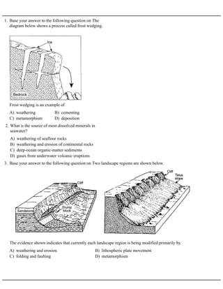
- 1. 1. Base your answer to the following question on The diagram below shows a process called frost wedging. A) weathering B) cementing C) metamorphism D) deposition Frost wedging is an example of A) weathering of seafloor rocks B) weathering and erosion of continental rocks C) deep-ocean organic-matter sediments D) gases from underwater volcanic eruptions 2. What is the source of most dissolved minerals in seawater? 3. Base your answer to the following question on Two landscape regions are shown below. A) weathering and erosion B) lithospheric plate movement C) folding and faulting D) metamorphism The evidence shown indicates that currently each landscape region is being modified primarily by
- 2. 4. Base your answer to the following question on The diagram below shows the stump of a tree whose root grew into a small crack in bedrock and split the rock apart. A) chemical weathering B) deposition C) erosion D) physical weathering The action of the root splitting the bedrock is an example of A) moist and warm B) moist and cold C) dry and cold D) dry and warm 5. Chemical weathering occurs most rapidly in climates which are A) the cracking of rock caused by the freezing and thawing of water B) the transportation of sediment in a stream C) the reaction of limestone with acid rainwater D) the formation of a sandbar along the side of a stream 6. Which is the best example of physical weathering? A) hydrosphere and lithosphere B) mesosphere and thermosphere C) hydrosphere and atmosphere D) lithosphere and atmosphere 7. Chemical weathering will occur most rapidly when rocks are exposed to the A) cold and humid B) cold and arid C) hot and humid D) hot and arid 8. Chemical weathering of rocks occurs most rapidly in a climate that is A) a warm, dry climate B) a cold, dry climate C) a warm, moist climate D) a cold, moist climate 9. Chemical weathering would be most effective in 10. Base your answer to the following question on the diagram below, which shows a surface and cross-sectional view of a portion of the Earth 15 kilometers from a mountain range. A) metamorphism B) cementation of sediments C) biological activity D) melting of rock material The processes that change the boulder and cobbles into soil are weathering and A) cool and dry B) cool and wet C) warm and dry D) warm and wet 11. Landscapes will undergo the most chemical weathering if the climate is A) less B) greater C) the same 12. A large rock is broken into several smaller pieces. Compared to the rate of weathering of the large rock, the rate of weathering of the smaller pieces is
- 3. 13. Base your answer to the following question on The two photographs below show dates on tombstones found in a cemetery in St. Remy, New York. The tombstones were 5 meters apart and both faced north. Tombstone A had dates cut into the rock in 1922. Tombstone B had dates cut into the rock in 1892. A) Tombstone A is composed of minerals less resistant to weathering than tombstone B. B) Tombstone A has undergone a longer period of weathering than tombstone B. C) Tombstone A experienced cooler temperatures than tombstone B. D) Tombstone A was exposed to less acid rain than tombstone B. Which statement best explains why the dates are more difficult to read on tombstone A than on tombstone B? 14. Base your answer to the following question on The diagram below shows an outcrop of different layers of sandstone in a region receiving heavy rainfall. A) A B) B C) C D) D Which sandstone layer appears to be the least resistant to weathering? 15. Base your answer to the following question on the Earth Science Reference Tables and the diagram below. The diagram represents two branches of a valley glacier. Points A, B, G, and H are located on the surface of the glacier. Point X is located at the interface between the ice and the bedrock. The arrows indicate the general direction of ice movement. A) biologic activity B) frost action C) acid reactions D) chemical reactions Which type of weathering most likely is dominant in the area represented by the diagram? 16. Base your answer to the following question on the Earth Science Reference Tables and the diagram below. The diagram represents a geologic cross section of a portion of the Earth's crust. The rock layers have not been overturned. A) sandstone B) shale C) conglomerate D) limestone Which type of rock appears to be most resistant to weathering? A) nitrogen B) hydrogen C) water D) argon 17. Which substance has the greatest effect on the rate of weathering of rock?
- 4. A) cold and dry B) warm and dry C) cold and moist D) warm and moist 18. In which type of climate does the greatest amount of chemical weathering of rock occur? A) B) C) D) 19. Which graph best represents the chemical weathering rate of a limestone boulder as the boulder is broken into pebble-sized particles? 20. Base your answer to the following question on the Earth Science Reference Tables, the geologic cross section of bedrock shown below, and your knowledge of Earth science. The cross section shows bedrock exposed along part of the Genesee River in New York State. The rock has not been overturned. A) shales B) gypsum C) dolostones D) salt Which rock layers in this formation appear to be the most resistant to weathering?
- 5. 21. Base your answer to the following question on The diagram below represents a sedimentary rock outcrop. A) 1 B) 2 C) 3 D) 4 Which rock layer is the most resistant to weathering?
- 6. 22. Base your answer to the following question on the map and cross sections below. The map shows measured changes in the position of Niagara Falls since 1678. The cross sections show the two parts of Niagara Falls: Horseshoe Falls and American Falls. Letters A through D represent the same rock layers at both locations. A) A B) B C) C D) D Which rock layer shows the most resistance to weathering and erosion at Horseshoe Falls?
- 7. 23. Base your answer to the following question on The cross section below shows sedimentary bedrock layers A, B, C, and D exposed at Earth’s surface. A) A B) B C) C D) D Which layer appears to be the least resistant to weathering? 24. Base your answer to the following question on The generalized cross section below shows the sedimentary rock layers at Niagara Falls in western New York State. A) Lockport dolostone B) Rochester shale C) Grimsby sandstone D) Queenston shale Which rock layer appears to be most resistant to weathering and erosion?
- 8. 25. Base your answer to the following question on The block diagram below shows a cross section of a landscape. Letters A, B, C, D, and E represent different rock layers. A) A and B B) B and D C) C, D, and E D) A, C, and E Which rock layers appear to be most resistant to weathering? A) Rocks A and C are made of larger particles than rock B. B) The particles in rocks A and C are more firmly cemented than those in rock B. C) The minerals in rocks A and C erode faster than those in rock B. D) Rocks A and C have not been exposed to weathering as long as rock B. 26. What is the best explanation for the shape of the cliff in the diagram? A) I and II B) II and III C) I and III D) II and IV 27. In the cross section of the hill shown below, which rock units are probably most resistant to weathering?
- 9. 28. Base your answer to the following question on the cross section below, which shows the bedrock of a portion of the Helderberg Escarpment, located in Thacher State Park near Albany, New York. The rock formations are identified by name. A) Esopus and Oriskany B) Onondaga and Coeymans C) Schoharie, and Marcellus and Hamilton D) New Scotland, and Schenectady and Indian Ladder beds Which formations appear to be the most resistant to weathering?
- 10. 29. The diagram below represents a cross section of a series of tilted sedimentary rock layers that have recently been uplifted from sea level. The entire flat surface is exposed to weathering and erosion by the same climate. The graph shows the relative rate of rock weathering in this particular climate. A) B) C) D) Which cross-sectional diagram best represents the probable landscape development after a period of 50,000 years? 30. The diagram below represents a cross section of a portion of the Earth's crust. A) erosion of the surface of rock layer A B) folding of rock layer B C) deposition of rock layer C D) faulting along line XY Which geologic event is the most recent? A) erosion of continental rocks B) submarine landslides from the mid-ocean ridges C) icebergs that have broken off of continental glaciers D) submarine volcanic eruptions 31. The major source of sediments found on the deep ocean bottom is 32. The diagram below represents a landscape area. A) wind erosion B) wave erosion C) stream erosion D) glacial erosion The labeled surface features of this landscape area resulted mainly from 33. The diagram below shows a hand-sized rock sample with parallel sets of grooves. This rock sample was found in a gravel bank in central Vermont. A) stream erosion B) wind erosion C) a landslide D) glacial erosion The grooves were most likely caused by
- 11. 34. The diagrams below show the stages, A through D, in the formation of an oxbow lake over a period of time. [The arrows indicate the direction of streamflow.] A) erosion, resulting in a sudden increase in the stream's gradient B) deposition, resulting in a sudden increase in the stream's gradient C) erosion along the outside banks of the curve in a meandering stream D) deposition along the outside banks of the curve in a meandering stream Oxbow lakes are generally formed by
- 12. 35. The photograph below shows an eroded plateau found in the southwestern United States. A) crustal uplift and stream erosion B) crustal uplift and glacial erosion C) crustal folding and stream erosion D) crustal folding and glacial erosion The landscape was developed by the processes of 36. The diagram below shows a portion of a stream. A) erosion due to a decrease in stream velocity B) erosion due to an increase in stream velocity C) deposition due to a decrease in stream velocity D) deposition due to an increase in stream velocity The sand bars formed as a direct result of 37. The picture below shows a geological feature in the Kalahari Desert of southwestern Africa. A) wind erosion B) volcanic eruption C) earthquake vibrations D) plate tectonics Which process most likely produced the present appearance of this feature?
- 13. 38. Base your answer to the following question on The cross section below shows a soil profile. A) erosion by glaciers B) erosion by running water C) capillarity and human activity D) weathering and biological activity This soil was formed primarily by A) human beings B) running water C) wind D) glaciers 39. The chief agent of erosion on Earth is 40. The map below shows a stream flowing into a lake. Locations A, B, and C are at the water's edge, and location D is on the lake bottom. A) Erosion is dominant at A and C; deposition is dominant at B and D. B) Erosion is dominant at B and C; deposition is dominant at A and D. C) Erosion is dominant at A and D; deposition is dominant at B and C. D) Erosion is dominant at B and D; deposition is dominant at A and C. Which statement best describes erosion and deposition in this stream area 41. Base your answer to the following question on the diagram below, which represents the landscape features associated with a meandering stream. Points W, X, Y, and Z are locations along the stream bank. A) W B) X C) Y D) Z At which location is erosion greatest?
- 14. 42. Base your answer to the following question on the diagram below, which represents the landscape features associated with a meandering river. Letters W, X, Y, and Z represent locations on the floodplain. A) W B) X C) Y D) Z At which location is erosion greatest? 43. The map below shows the area surrounding a meandering stream. A) A B) B C) C D) D At which point is erosion greatest? 44. The map below shows the top view of a meandering stream as it enters a lake. A) Erosion is dominant at A and D, and deposition is dominant at B and C. B) Erosion is dominant at B and C, and deposition is dominant at A and D. C) Erosion is dominant at A and C, and deposition is dominant at B and D. D) Erosion is dominant at B and D, and deposition is dominant at A and C. At which points along the stream are erosion and deposition dominant?
- 15. 45. Base your answer to the following question on The photograph below shows an arch of rock located in the western United States. A) The bedrock in the arch was more resistant to weathering and erosion than the surrounding bedrock that was removed. B) An earthquake forced bedrock upward into the shape of an arch. C) Sand and gravel were deposited and compacted in the shape of an arch. D) An underground glacier tunneled through the bedrock. How did the arch most likely form? 46. The diagram below represents a geologic cross section of a portion of the Earth's surface. The letters identify different layers of sedimentary rock. A) A B) B C) C D) D Which rock layer is probably the most resistant to erosion? A) It flows slowly, producing a V-shaped valley. B) It flows slowly, producing a U-shaped valley. C) It flows rapidly, producing a V-shaped valley. D) It flows rapidly, producing a U-shaped valley. 47. Which statement best describes a stream with a steep gradient? 48. Base your answer to the following question on the diagram which represents a profile of a mountain glacier in the northern United States. A) U-shaped valley with polished bedrock B) V-shaped valley with jagged bedrock C) flat plain with bedrock that has been metamorphosed D) deep ocean trench with bedrock that has been melted and cooled If the climate warms, causing the glacier to melt away, the region that the glacier formerly occupied will be a 49. The diagram below shows a glacial landscape. A) U-shaped valleys B) many stream valleys C) sorted sediment on the valley floor D) the landslide near the valley Which evidence suggests that ice created this landscape?
- 16. 50. Base your answer to the following question on the photograph below, which shows a mountainous region cut by a large valley in its center. What characteristic of this large valley supports the inference that glacial ice formed the valley? A) mass movement B) wave action C) running water D) glacial ice 51. U-shaped valleys and parallel grooves in bedrock are characteristics of erosion by A) glaciers B) wind C) wave action D) running water 52. A landscape region that has broad, U-shaped valleys with polished and grooved bedrock was most likely formed by A) running water B) ocean currents C) wind D) glacial ice 53. Which agent of erosion formed the long U-shaped valleys now occupied by the Finger Lakes in central New York State? A) a glacier B) a stream C) waves D) wind 54. The occurrence of parallel scratches on bedrock in a U-shaped valley indicates that the area has most likely been eroded by 55. The cross section below shows a V-shaped valley and the bedrock beneath the valley. A) surface winds B) running water C) glacial ice D) ocean waves Which agent of erosion is responsible for cutting most V-shaped valleys into bedrock?
- 17. 56. Base your answer to the following question on the cross section below, which represents part of the Atlantic Ocean seafloor. An earthquake occurred on November 18, 1929, triggering an underwater sediment flow. The location of the epicenter is labeled. Letters A through D indicate locations on the seafloor. Time, in hours, at each lettered location represents the arrival of the sediment flow after the earthquake. Calculate the gradient of the ocean floor between locations A and D and label your answer with the correct units. Gradient = __________________ A) decreases B) increases C) remains the same 57. As the gradient of a stream increases, the stream's ability to carry sediment
- 18. 58. Base your answer to the following question on the Earth Science Reference Tables and the diagrams below. Diagram I represents a stream's profile before an earthquake. Diagram II represents the same stream's profile after an earthquake elevated a portion of the land and produced a waterfall. A) less B) greater C) the same Compared to the stream's average gradient before the earthquake, the stream's average gradient after the earthquake is
- 19. 59. Base your answer to the following question on the topographic map below. Points X and Y are locations on Squab Hollow Creek. Determine the gradient of Squab Hollow Creek between point X and point Y by following the directions below. a Write the equation used to determine the gradient. b Substitute values into the equation. c Solve the equation and label the answer with the correct units. A) decreases B) increases C) remains the same 60. If the gradient of a stream increases at a certain location, the probability that sediment will be deposited at that location
- 20. 61. Base your answer to the following question on the contour map below. Points A, B, Y, and Z are reference points on the map. Note that portions of the map are incomplete. A) 26 m/km B) 70 m/km C) 130 m/km D) 350 m/km The gradient of Blue Stream between point A and point B is approximately
- 21. 62. Base your answer to the following question on the topographic map shown below. Points A, B, C, and D are reference points on the map. Elevations are measured in meters. Calculate the gradient of Long Creek between points C and D and label the answer with the correct units. Base your answers to questions 63 and 64 on the profile shown below, which shows the pattern of horizontal sorting produced at a particular time when a sediment-laden stream enters the ocean. A) a decrease in the stream's gradient B) a decrease in the amount of sediment in the stream C) an increase in the stream's discharge D) an increase in the density of the sediment 63. Which change in the stream would cause pebbles to be deposited farther offshore? A) decreases in width B) decreases in kinetic energy C) increases in potential energy D) increases in velocity 64. Deposition of these sediments occurs when a stream enters the ocean because the stream current A) glaciers B) streams C) winds D) ocean waves 65. Which erosional agent typically deposits hills of unsorted sediments? A) wind B) glacial ice C) running water D) ocean waves 66. A deposit of rock particles that are scratched and unsorted has most likely been transported and deposited by A) wind B) glaciers C) ocean waves D) running water 67. How would unsorted piles of angular sediments most likely be transported and deposited?