1. 2002 TAC Sustainable Transportation Award
Nomination: Dismantling the F.G. Gardiner Expressway East
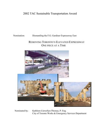
REMOVING TORONTO’S ELEVATED EXPRESSWAY
ONE PIECE AT A TIME
Nominated by: Kathleen Llewellyn-Thomas, P. Eng.
City of Toronto Works & Emergency Services Department
2. - 2 -
REMOVING TORONTO’S ELEVATED EXPRESSWAY ONE PIECE AT A TIME
Dismantling the F.G. Gardiner Expressway East
Fact Sheet
Owner: City of Toronto
Works & Emergency Services Department
Barry Gutteridge, Commissioner
Engineering Consultants: URS Cole Sherman
Morrison Hershfield
Shaheen &Peaker
Lura Consultants
Urban Design Consultants: DuToit Allsopp Hillier
Artist: John MacKinnon
Contractor: Grascan Construction Ltd./ Torbridge
Construction Ltd.
(main contract)
Project Cost: $41,301,000
Planning: 1996 to 2000
Construction: April 2000 to December 2002
(plantings to be completed April 2003)
3. - 3 -
REMOVING TORONTO’S ELEVATED EXPRESSWAY ONE PIECE AT A TIME
Dismantling the F.G. Gardiner Expressway East
Introduction
Dismantling the easterly portion of Toronto’s elevated F.G. Gardiner Expressway has
opened the lands adjacent to it for redevelopment, encouraged cycling and walking in a
highway corridor previously dominated by vehicular traffic, and created an urban place for
a residential community living in the shadow of the elevated expressway for close to 40
years. In every sense the Gardiner Expressway East Dismantling has demonstrated the
principles of sustainable urban transportation – encouraging varied modes of transportation
and supporting urban intensification to maximize use of existing infrastructure while
minimizing taxpayer’s costs. The project replaced 1.4 km of the 6 lane elevated
expressway with a 4 lane arterial road paralleled by a pedestrian /cycle path and landscaped
boulevard. The project featured public art elements and an environmental cleanup of
contaminated soils. The following sections detail the history of the project and its
construction. The remaining sections detail the ways in which this project exemplifies the
New Vision for Sustainable Urban Transportation.
Project Background
The F.G. Gardiner Expressway is an elevated highway built along the waterfront of the
City of Toronto. Built almost 40 years ago it was one component of an expressway grid
planned to service the growing metropolis. The Gardiner Expressway was planned to
extend from the Humber River in the west to the Scarborough Expressway and East Metro
Freeway 20 km. to the east. In the late 1960’s and early 1970’s however, planning
philosophy was changed by citizen activism and the ambitious expressway plan for
Toronto was abandoned in the face of public opposition.
The elevated portion of the F.G. Gardiner Expressway which began at Dufferin Street had
been terminated at Leslie Street with a pair of ramps providing the transition from the six
lane elevated expressway to a four lane arterial road.
In the early 1990’s the most easterly 1.4 km of the elevated expressway leading to the
ramps at Leslie Street was identified as requiring significant rehabilitation. In view of the
relatively low traffic demand and the high cost of the repairs, the City conducted planning
studies including a life cycle cost analysis and environmental assessment. The City
concluded, on the basis of long-term savings, redevelopment opportunities and urban
design considerations, that the best solution was to dismantle the elevated expressway from
the Don River to Leslie Street. The photograph below shows the location and scope of the
dismantling.
4. - 4 -
F.G. Gardiner Expressway East Dismantling
Looking West from Leslie Street
Project Features
The Gardiner Expressway between Leslie Street and the Don River has been replaced with
a four lane arterial road with a centre median. At the very easterly end, close to the Don
River and at the new terminus of the elevated expressway, the highway ramps down to
Lake Shore Boulevard. Pavement markings, signage and rumble strips warn eastbound
motorists that there is a change in roadway environment coming up and that they should
slow down. 400 metres from the ramp terminus is the signalized intersection at Carlaw
Avenue which completes the transition from expressway to city street. The drawing below
shows the overall plan for the project.
Urban Design Plan
Dismantle
1380 metres
Elevated
Expressway
Leslie Street
5. - 5 -
On the north side of Lake Shore Boulevard a minimum 5 metre wide pedestrian/bicycle
path has been built in the space freed up by the expressway demolition. The path completes
the pedestrian/ bicycle system by linking cycling paths in Toronto’s “Beach” community
with the commuter and recreational bicycle facilities in the Don Valley park system and the
Martin Goodman bicycle path along the City’s waterfront. The pictures below illustrate the
improvements. The “after” pictures are computer renderings because the construction
finished in December 2002, and plantings have not been completed.
Before & After at Carlaw Avenue
Looking West towards Downtown
Before Dismantling After Dismantling
The Gardiner Expressway East Dismantling project also included the construction of a
pedestrian/cycling bridge over the Don River, filling in a key missing link in the network
and providing safe and comfortable conditions for pedestrians and cyclists in this busy
transportation corridor.
Pedestrian/Cycle Bridge over Don River
6. - 6 -
Because of the opportunity for city building afforded by the dismantling, the design team
included professionals in the field of urban design as well as a professional artist
experienced in creating public art. The input of these professionals has resulted in a
landscape plan which beautifies the corridor, adds to the urban forest and which requires
minimum maintenance. The public art component is discussed in more detail later in this
submission, but the result of the artist’s input has been to commemorate the historical at the
same time as celebrating the new urban place created by the dismantling of the expressway.
Before & After at Booth Street
Looking West towards Downtown (note CN Tower in both pictures)
Before Dismantling After Dismantling
The final major feature of this project which is important to note is that the entire planning,
design and construction effort was done in consultation with the community through a
Design and Construction Liaison Group. Like all major urban transportation projects, the
Gardiner East Dismantling had considerable interest from the public; some in favour,and
some against the project. The design and construction team of city staff, consultants and
contractors met regularly with the stakeholders addressing their concerns, incorporating
their ideas and listening to their complaints. While not all participants could be 100%
satisfied with the outcome of each discussion, they were satisfied with being heard and as a
result there were very few complaints or issues raised with the three affected local
Councillors.
Contribution to Sustainable Transportation
The City of Toronto Official Plan (OP) calls for the addition of 375,000 residents and
350,000 new jobs over the next 25- 30 years. The principle behind the OP is to contain
urban sprawl around Toronto by infilling existing built areas with new development and
revitalizing under-utilized or abandoned industrial/commercial lands and brownfields sites.
This form of growth can be supported primarily by existing infrastructure or by upgrades to
7. - 7 -
existing services and infrastructure. The plan is to improve the live-work-shop proximity
relationship and reduce automobile dependence in the City. The plan emphasises the need
to redevelop along specific existing “Avenues” which will be upgraded to be compatible
with mainstreet urban design; they will be pedestrian-friendly, provide a high level of
transit service and encourage street level activity at all times of the day and evening.
The Dismantling of the F.G. Gardiner Expressway East is a large scale example of creating
urban streets where highways previously existed. In dismantling the elevated structure and
replacing it with a four lane road, pedestrian/cycling path and landscape, the City of
Toronto has created opportunities for developments to turn around and face the street.
Lands adjacent to the road have been given “address” and visibility so it will now be
possible to build developments to face the street, providing the “eyes on the street” needed
for lively, secure and comfortable pedestrian and cycling activity. The location of the
newly created Lake Shore Boulevard adjacent to Toronto’s under-utilized Portlands, makes
it a catalyst for the redevelopment of the city’s waterfront in the new urbanist vision
articulated in the Toronto OP.
Innovation in Design
One of innovations the City of Toronto employed in the Gardiner Dismantling was the
inclusion of an urban design specialist and an artist at the outset of the project. These two
professionals worked closely with the design team and incorporated the many features of
this transportation project which transformed it into an urban renewal project. The public
art includes relief work on the concrete retaining walls of the transition ramp, a mosaic in
the sidewalk at Leslie and Lake Shore and, most surprisingly to the public, the retention of
some of the old concrete columns.
The engineering design and construction of the Gardiner Dismantling was an enormous
challenge which pushed the contractor, consulting engineers and city staff to be as creative
as possible. Although the urban design and city building benefits of the project were widely
recognized, the dismantling project was extremely controversial. The local Councillors and
public were concerned about traffic congestion, local railway traffic, vibration and dust, the
effect on cyclists in the corridor, the effect of construction on local industry, and the
disturbance of property in the Expressway corridor known to have significant soil
contamination. As a result of these issues, the project was constrained by the following
commitments:
1. Keep traffic access to the remaining elevated expressway in the west open at all
times.
2. Minimize traffic disruption and the duration of construction.
3. Minimize noise effects on adjacent film studios.
4. Accommodate cyclists through the construction site
5. Manage contaminated soil in consultation with the community
6. Manage all design and construction issues in consultation with a Community
Advisory Committee.
8. - 8 -
The design team and contractor were able to stage construction and employ dismantling
techniques that shortened the dismantling time from 48 months to 24 months. This was
accomplished through the use of hoe rams and by dropping the steel girders onto the
ground below the expressway instead of lifting the girders down and then removing the
concrete columns. By breaking off the south edge of the expressway and building the
transition ramp one half at a time the team was able to keep access to and from the
remaining elevated expressway open at all times. The team developed an on-site protocol
where the film studios would phone the site supervisor to halt construction for minutes or
hours during the shooting of particular film sequences in the two adjacent film studios.
Noise and dust were monitored throughout the construction and kept within acceptable
standards.
Cyclists were accommodated by either rerouting them to a parallel route or by creating a
temporary space for them through the site. All the plans for rerouting the cyclists were
developed in consultation with the Design and Construction Liaison Group who
participated in every phase of the design and construction.
The City of Toronto responded to the discovery of contaminated soil in the right of way by
conducting a Site Specific Risk Assessment which recommended a soil cap consisting of
geotextile, excavation of hot spots and a soil and sod cap. The issue of the soil
contamination was extremely controversial as the public liaison group wanted the City to
remove the soil completely for a cost of $25Million. The soil cap is a sustainable and
affordable alternative for dealing with contaminated rights-of-way.
Cost Effectiveness
The $41,000,000 dismantling begins saving the City of Toronto money in the first 10 years
after completion. Before proceeding with the project, the city conducted a life cycle cost
analysis to determine the costs of dismantling the expressway compared to rehabilitating it.
The 50 year life cycle cash flows were adjusted to provide a net present value (NPV) and
showed that the City would save $14 Million over the life of the structure. However, the
cash flows, when plotted against time, show that while the dismantling is capital intensive
in the first 4 years, it breaks even at the year 8 mark and begins saving the City money in
ten years.
Applicability across Canada
While not every urban centre in Canada has a $41Million expressway to dismantle, many
of the philosophical approaches which informed this work can be applied to transportation
projects across the country.
Every transportation project provides the opportunity to leave the city a better place for
having been built. The Gardiner Dismantling project not only saved the City money in life-
cycle costs, but also replaced an automobile dominated corridor with a multi-modal urban
street. The city-building approach to the project’s design led to the incorporation of public
9. - 9 -
art and urban design principles, which, when combined with tree planting, have improved
the possibility of redevelopment on the adjacent lands. By including the public in the
planning, design and construction of the project, the City engaged the public in an
important discourse about transportation policy and issues. And finally, the City used the
discovery of contaminated soil in the right-of-way as an opportunity to improve the
environment for the adjacent neighbourhood.
Each of these approaches – look at long term costs, look for multi-modal opportunities, use
urban design principles, plant trees, engage the public and clean up as you go - can be
applied to all kinds of projects from the smallest intersection improvement to the largest
roadway upgrade, regardless of their scale or cost. It is the application of these principles
that will make the New Vision for Sustainable Urban Transportation a reality across the
country.